Please register to participate in our discussions with 2 million other members - it's free and quick! Some forums can only be seen by registered members. After you create your account, you'll be able to customize options and access all our 15,000 new posts/day with fewer ads.
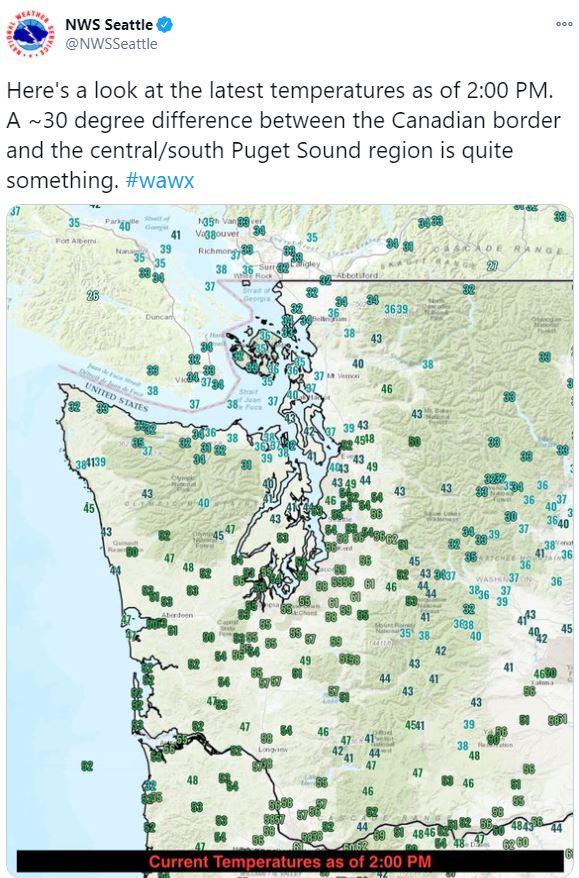
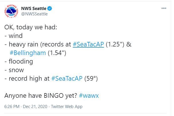
Pretty wild weather day up here in the Pacific Northwest on the Winter Solstice! It's 33 degrees and dumping snow here. Meanwhile in Seattle, just 80 miles to the south, it's 50 degrees with heavy rain and a flood advisory. It might snow there later too!
Here's an interesting factoid via Twitter: ""Sea-Tac was 23 F warmer than Bellingham at 1 PM. In case you're wondering if that is a record, I pulled hourly obs back to 2010 and there are only TWO instances of >23 F difference between the two sites: 3/19-20, 2019. Peaked at 28 F difference on 3/19/19: KSEA: 61 F, KBLI: 33 F"
Last edited by Satellite_Anthem; 12-21-2020 at 05:06 PM..
This is for Christmas Eve night 1am... Santa is going to be wet but some areas that have this crazy front pass through will see the changeover to snow. We'll see if the Big Cities see any change to snow. Would be Christmas morning.
To be officially a White Christmas for the Climo Sites they need snow on ground Christmas Day 7am since that's when they do the measurements.
So You got Warm, Strong South Winds, Rain and even Thunderstorms on one side, and Cold, North Winds, Snow on the other side.
Love/Hate these Sharp Fronts.
I think Euro is winning...AGAIN! GFS looks to be slower with the front. How does that Euro model do it??
If you click on "previous Run" on Tropical TidBits you'll see the differences for that same time frame. Notice how much further East the front was with previous runs. GFS had all that money put in to upgrade it and still cannot compete with the Euro. incredible.
Very much so! Usually a temperature gradient like this is during an Arctic front or overrunning event. This is just from a strong low bringing in cold marine air and heavy precipitation dragging that cold air down to the surface.
Just measured about two inches on cars, an inch on the road, and three inches on the grass.
Today was one of my favorite weather days ever up here. It just usually isn't this dynamic in this region. Plus wet snow looks prettier than dry snow. Even the brief power outage we had was fun.
Temps keep dropping for Christmas. Now a low Christmas morning of 23, high of just 34 (gotta imagine that could change and the high will struggle to reach freezing), low of 21 the next morning. We haven't had a December morning below 20 in 10 years. It's def not common outside of January. It can happen in Dec and Feb (or even Nov) but it's pretty rare. In fact, last winter and the winter of 12-13 didn't even drop below 20.
Please register to post and access all features of our very popular forum. It is free and quick. Over $68,000 in prizes has already been given out to active posters on our forum. Additional giveaways are planned.
Detailed information about all U.S. cities, counties, and zip codes on our site: City-data.com.

 Please register to participate in our discussions with 2 million other members - it's free and quick! Some forums can only be seen by registered members. After you create your account, you'll be able to customize options and access all our 15,000 new posts/day with fewer ads.


")


