Please register to participate in our discussions with 2 million other members - it's free and quick! Some forums can only be seen by registered members. After you create your account, you'll be able to customize options and access all our 15,000 new posts/day with fewer ads.
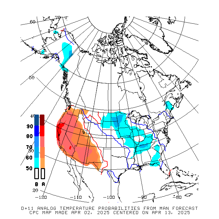
That above was from yesterday morning. Check out the latest GFS. It shifts the trough over Alaska which = ridge in west instead and trough in East. I actually believe this setup more. Here's the temp anomaly from it for June 27-29
Here's why I believe it... NAO...negative... Blocking over Greenland keeps better chance for trough in East IF the trough over Alaska happens.. Everything is tied together it's always so hard to show a couple things
does this mean clouds and rain for us? Or just cool weather?
I find clouds and rain are so much harder to pick out. I think because they are 2 things that change much quicker and depend on shorter circumstances. Temps are easier in many ways. But I have to assume that with a cool flow aloft and sun angle and warmer season that some clouds would be around too with that setup. Unless a surface High comes in. Then you're talking clear and seasonable/cool.
Wildlife experts have warned that many migratory bird chicks may perish due to the extremely cold nights recently. The parents have to spend most of the day sheltering the chicks and can't go searching for food.
Yes, yes, some of you may say "well, your so far north", but this cold weather is very extraordinary and nothing we've seen in 50 years. In many inland parts of Finland the lows have been around 25% of the normal, which would mean 3-4C (37-40F) lows in Chicago for example.
this June is definitely warmer than June 2009, it's already warmer than the entire average of June 2009 (for here, other locations are probably similar)>
As of yesterday, ORD has an average max of 79.2F and a Mean of 69.1F. MDW's average max is 80.7F with a Mean of 71.5F. So basically where we should be for the entire month but only 18 days into it....
Let's not right off a warm end to June just yet. This was produced yesterday....
Current Radar, Temps & Satellite. Front is sagging south. First batch of rain got me, now it's south of here getting NYC. Dewpoints north of me I see are in 50s. I can feel the air changing.
Richmond VA with their 4th day in a row of 90s. 8 for the month. Average is 9.
In 2010 they had 19 days in the 90s in June alone!
Love this tropical day. 88 feels like 93. Heard some thunder but we probably won't get a direct hit. Looking to the southwest is just a massive white wall of cumulonimbus.
Please register to post and access all features of our very popular forum. It is free and quick. Over $68,000 in prizes has already been given out to active posters on our forum. Additional giveaways are planned.
Detailed information about all U.S. cities, counties, and zip codes on our site: City-data.com.

 Please register to participate in our discussions with 2 million other members - it's free and quick! Some forums can only be seen by registered members. After you create your account, you'll be able to customize options and access all our 15,000 new posts/day with fewer ads.