Please register to participate in our discussions with 2 million other members - it's free and quick! Some forums can only be seen by registered members. After you create your account, you'll be able to customize options and access all our 15,000 new posts/day with fewer ads.
Snow pack is holding steady here around 8 inches. Today was the 11th straight day with snow on the ground. I expect that streak to go at least another week or even two. We also have a nice month-long streak going without reaching 10C anywhere in the metro area, almost six weeks in fact for KNYC. All in all, it's not as disgustingly warm of a winter as I expected it to be, despite La Nina and the SE ridge and all of the other garbage in place.
Texas is in the middle of the country which allows the cold to dig down easier.
I used to think this too. But, the reality is, what happens in Texas (and can often extent into the Northern Gulf states) is, essentially, one gigantic cold-air damming (CAD) event.
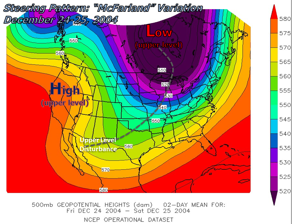
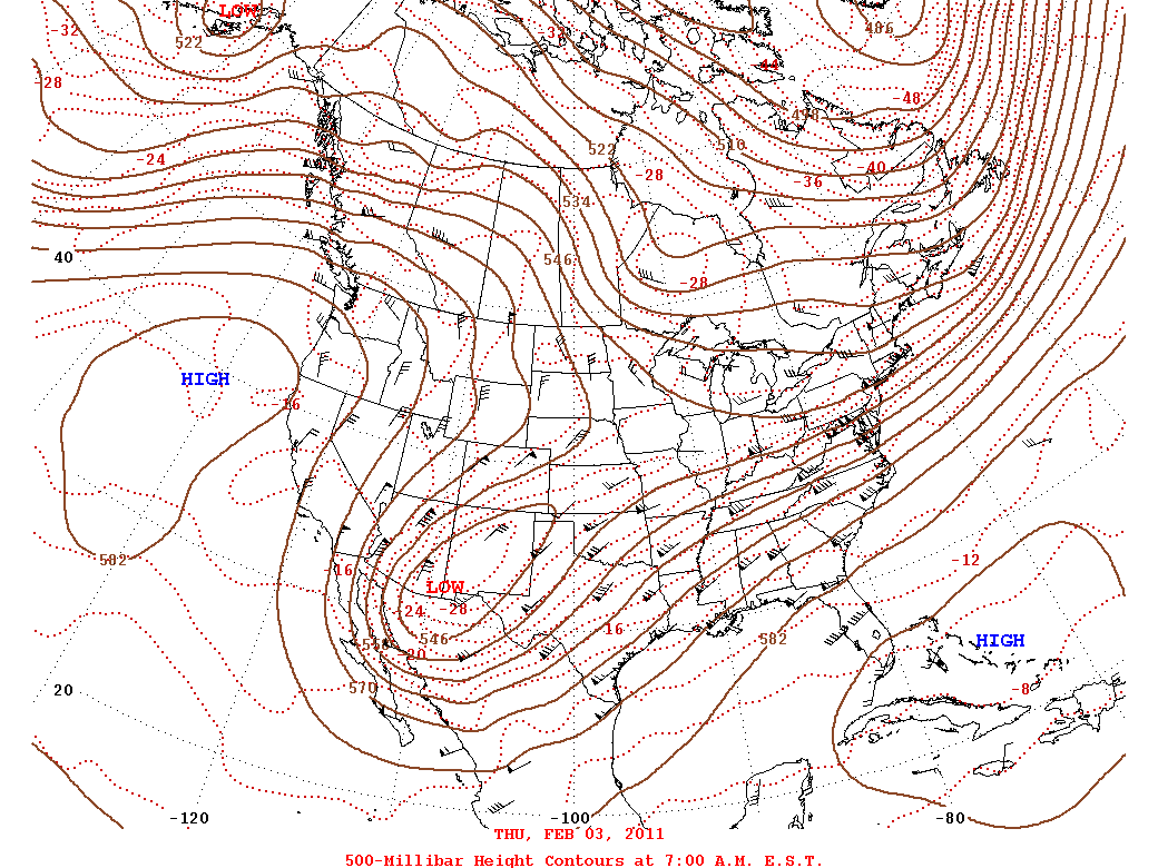
I've looked a lot into upper-air patterns, and one thing that stands out is the HIGH frequency of upper level trough formations and/or occurrences over the SW US/Northern Mexico region. It doesn't matter whether its a shortwave or a bowling ball longwave/cut-off low, there's almost always some type of disturbance finding its way into that region - and often with that same positive tilt as well.
These formations are responsible for the winter precipitation events that interrupt what would otherwise be perfectly dry, warm winter weather in Texas. The reason is, when they set up shop in the SW US, that puts Texas under a SW flow aloft emanating from the trough base - and you know that the right side of the trough base is divergent aloft, meaning that there are numerous disturbances (and resulting precipitation) that can ride the state all winter long. This ALONE isn't bad at all - just leads to alternating sunny winter, with some brief rain interruptions, in the vein typical of med/humid subtropical climates during winter.
The problems begin with that gets COMBINED with pure flat land up to the Arctic, along with a huge mountain range directly west to funnel the outbreaks south. A low pressure in the Northern US can advect down a cold front, dammed by the Rockies, funneling down into Texas. But, because the upper-level flow is unchanged, the front ends up shallow, and undercuts, creating a wide range of miserable conditions - overcast, cold rain, as well as wintry precip like what's on the table. Then, when the upper level trough moves in, that creates a surface low that moves away, and pulls colder air further into Texas. The worst part is, these surface lows form often in the warm waters of the Gulf, creating what is, essentially, the Texas version of a Nor'Easter - that means you deal with cold RIGHT AFTER sustained wintry precip.
I've got some examples below that depict upper-air patterns over Texas during these events, which show exactly what I mean. Two of the graphics below show the snow event in Southern Texas from early December of 2017, and one graphic shows the ice storm that struck Texas in Feb of 2011. Notice the positive tilt, the orientation from NE to SW. It even has a name, the "McFarland Signature."
I think the SE Ridge is stronger than the models are taking into account. That was a miss by ~10F in the forecast. Every day has been warmer than predicted.
Lake house just barely hit 71. And briefly. But it actually hit 71 in December and 73 in January.
Ours have been off by a few degrees. Yesterday ended up 2 or 3 degrees warmer than Monday's forecast. Today was supposed to be 63 and we beat that by 5 degrees. Tomorrow is supposed to be 63 but with rain so we'll see.
Snow pack is holding steady here around 8 inches. Today was the 11th straight day with snow on the ground. I expect that streak to go at least another week or even two. We also have a nice month-long streak going without reaching 10C anywhere in the metro area, almost six weeks in fact for KNYC. All in all, it's not as disgustingly warm of a winter as I expected it to be, despite La Nina and the SE ridge and all of the other garbage in place.
Well, bring out the snow potential for the Ohio Valley. The model output couldn't possibly be much higher.
See attached:
Over two feet of snow potential on the 18Z run for Louisville and Cincinnati. The odd thing is that the 12Z run had only somewhat less...
You sure that's not supposed to be ice? We're having an ice storm right now that is due to continue for another 24 hours or so before departing for Virginia. Cincinnati and northern Kentucky had a major snowfall just last night - the rest of Kentucky gets ice instead.
For now: THREE significant snow storms will visit us next week.
Harbin is getting to 2C today. What a warm-up for that ice box.
Please register to post and access all features of our very popular forum. It is free and quick. Over $68,000 in prizes has already been given out to active posters on our forum. Additional giveaways are planned.
Detailed information about all U.S. cities, counties, and zip codes on our site: City-data.com.

 Please register to participate in our discussions with 2 million other members - it's free and quick! Some forums can only be seen by registered members. After you create your account, you'll be able to customize options and access all our 15,000 new posts/day with fewer ads.