Please register to participate in our discussions with 2 million other members - it's free and quick! Some forums can only be seen by registered members. After you create your account, you'll be able to customize options and access all our 15,000 new posts/day with fewer ads.
It's hard to believe there's mild weather so close by since this February has been so cold. Other cold winters much of the country (midwest and southeast) were cold, too. I wonder if there could be a very drastic shift in average temperatures around the end of the month. I'd rather have a chilly February and a warm March than the reverse. I hated last March.
Your climate is very diff than mine here. No snow cover and the current temp is 50F on a cloudy day.
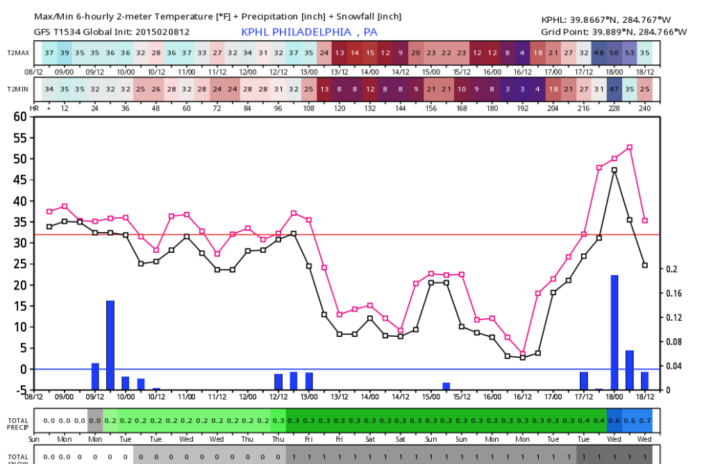
And shows you how wrong models can be even right on the same day. GFS operational had a high today for Philly of 39F. It is 50F now. The Euro operational has a high today of 49F for us, so much better forecast.
I'm finding the UK model is more accurate than the GFS, and even better than the Euro.
Mostly Cloudy
50°F
10°C
Humidity 39%
Wind Speed NE 5 mph
Barometer 29.82 in (1009.8 mb)
Dewpoint 26°F (-3°C)
Visibility 10.00 mi
Wind Chill 48°F (9°C)
Last Update on 8 Feb 1:54 pm EST
Current conditions at
Philadelphia, Philadelphia International Airport (KPHL)
Lat: 39.87°N Lon: 75.23°W Elev: 7ft.
Meanwhile Boston at
Light Snow Fog/Mist
21°F
-6°C
Humidity 85%
Wind Speed N 16 G 22 mph
Barometer 30.01 in (1016.0 mb)
Dewpoint 17°F (-8°C)
Visibility 1.50 mi
Wind Chill 7°F (-14°C)
Last Update on 8 Feb 1:54 pm EST
Current conditions at
Boston, Logan International Airport (KBOS)
Lat: 42.36°N Lon: 71.01°W Elev: 20ft.
And further south even better. 70F in Norfolk, VA.
Partly Cloudy
70°F
21°C
Humidity 23%
Wind Speed SW 17 G 23 mph
Barometer 29.85 in (1010.8 mb)
Dewpoint 30°F (-1°C)
Visibility 10.00 mi
Last Update on 8 Feb 1:59 pm EST
Current conditions at
Norfolk, Naval Air Station (KNGU)
Lat: 36.93°N Lon: 76.3°W Elev: 13ft.
And shows you how wrong models can be even right on the same day. GFS operational had a high today for Philly of 39F. It is 50F now. The Euro operational has a high today of 49F for us, so much better forecast.
Not sure which GFS you saw but... Yup...Here's what euro had for Philly from the 00z run yesterday. These aren't the max but had Philly near 50 today. But GFS wasn't off..
GFS max temps today from yesterday afternoons run. Just 24hrs out. Granted this is only 1 run and I didn't check the others but it wasn't bad at all especially for where the snowpack is.
This is why we cannot live and die by each update and we need a blend of all models
Last edited by Cambium; 02-08-2015 at 12:51 PM..
Reason: Fixed image
Today's stormy weather on the Estonian northern coast, at Tallinn. http://tv.delfi.ee/eesti/tormine-ilm-pirital?id=70743597
Media and newspapers here talked a lot about incoming storm although here where I live was just a windy weather but by far not any storm.
Meanwhile feels like 20s in NYC with wind and clouds
but can you see the bottom edge of the infamous front we been talking about for a week?? Had that been pushing south more we would be in the 10"+ snow zone.
Added the snowpack image to get an interesting sense of things.
Is the Front having a hard time move south because of lack of snowpack??
Not sure which GFS you saw but... Yup...Here's what euro had for Philly from the 00z run yesterday. These aren't the max but had Philly near 50 today. But GFS wasn't off..
GFS max temps today from yesterday afternoons run. Just 24hrs out. Granted this is only 1 run and I didn't check the others but it wasn't bad at all especially for where the snowpack is.
This is why we cannot live and die by each update and we need a blend of all models
This was their 12z run from today: direct your attention to the 39F at 09/00 (which is high temp for Feb 8th as the model is Zulu time). The airport hit at least 51F, and places along the NJ shore and in southern NJ even higher. I see a 61F at Millville.
This was their 12z run from today: direct your attention to the 39F at 09/00 (which is high temp for Feb 8th as the model is Zulu time). The airport hit at least 51F, and places along the NJ shore and in southern NJ even higher. I see a 61F at Millville.
interesting..I see.
So 00z was off by a few degrees. Strange this mornings 12z was off by a lot. Maybe bad ingestions? (like indigestion? lol) No idea.. Maybe it thought would be more cloudy instead??
For within 24hrs always best to use the short term models like RGEM, HRRR, HiRes NAM, HRW, ect ect, not the GFS or even Euro. Good to look at precip but not temps in such short range.
NATIONAL WEATHER SERVICE MOUNT HOLLY NJ
1121 AM EST SUN FEB 8 2015
IT STILL APPEARS THAT THERE WILL BE A MARKED DIFFERENCE IN TEMPERATURES
BETWEEN FAR NORTHERN NEW JERSEY AND SOUTHERN DELAWARE THIS
AFTERNOON BECAUSE OF THE FRONTAL BOUNDARY. WE ARE ANTICIPATING
HIGH TEMPERATURES MAINLY IN THE 30S TO THE NORTH OF INTERSTATE 78,
AND IN THE 40S FROM INTERSTATE 78 SOUTHWARD TO ABOUT PHILADELPHIA
AND THE CENTRAL PART OF THE NEW JERSEY COAST. IT WILL BE RATHER
MILD TODAY IN NORTHEASTERN MARYLAND, DELAWARE AND SOUTHERN NEW
JERSEY WITH TEMPERATURES EXPECTED TO RISE INTO THE 50S. WE MAY SEE
A FEW 60 DEGREE READINGS IN SOUTHERN DELAWARE.
Then an hour later... they raised their own max forecasts for today but they note the front was "faster" to be moving south. (I would of thought slower). So maybe the GFS thought the front was a bit too fast!
Quote:
NATIONAL WEATHER SERVICE MOUNT HOLLY NJ
1237 PM EST SUN FEB 8 2015
A DIFFUSE FRONTAL BOUNDARY HAS DROPPED ACROSS MUCH OF NJ AND ERN
PA TODAY. IT APPEARS TO HAVE MOVED A BIT FASTER THAN EARLIER EXPECTED. IT SHOULD CONTINUE TO MOVE SOUTHWARD THIS AFTERNOON
ACROSS THE DELMARVA.
CLOUDS WILL THICKEN ACROSS THE AREA THIS AFTERNOON. WITH MOSTLY
MID LEVEL CLOUDS OVER MOST AREAS. LOWER CLOUDS BANKED UP ACROSS SE
NY AND NE NJ WILL BEGIN TO MOVE ACROSS THE NRN AREAS LATE. PUSHED
BACK THE THE INCREASE IN SKY COVER A BIT WITH THE 12:30 PM UPDATE.
THERE IS A MARKED DIFFERENCE IN TEMPERATURES BETWEEN FAR NORTHERN
NEW JERSEY AND SOUTHERN DELAWARE THIS AFTERNOON BECAUSE OF THE
FRONTAL BOUNDARY. WE ARE ANTICIPATING HIGH TEMPERATURES MAINLY IN
THE 30S TO THE NORTH OF INTERSTATE 78, AND IN THE 40S FROM
INTERSTATE 78 SOUTHWARD TO ABOUT PHILADELPHIA AND THE CENTRAL PART
OF THE NEW JERSEY COAST. IT WILL BE RATHER MILD TODAY IN
NORTHEASTERN MARYLAND, DELAWARE AND SOUTHERN NEW JERSEY WITH
TEMPERATURES EXPECTED TO RISE INTO THE 50S, PUSHING 60. WE MAY SEE
A FEW 60 DEGREE READINGS IN SOUTHERN DELAWARE AS WELL. TEMPERATURES WERE RAISED ACROSS THE SOUTHEAST PART OF THE REGION WITH THE 12:30 PM UPDATE.
INCREDIBLE gradient in the NWS Baltimore/Washington CWA today. High of 41F at Hagerstown MD (cloud cover+cold wedge and even snow cover nearby) to 72F at Fredericksburg VA. D.C. (National Airport) tied its daily record high of 68F from 1900 today. The most dramatic gradient within one county, barring cooling at river/Bay-side stations, that I could find was 60F at Dulles cooling to 50F at Leesburg to the NW. Would have made for a good road trip in the metro area, but unfortunately I'm stuck in school in Pittsburgh, where the snow pack is almost completely gone = =
Quote:
ASUS61 KLWX 090015
RTPLWX
MAX/MIN TEMPERATURE AND PRECIPITATION TABLE FOR THE MID-ATLANTIC
NATIONAL WEATHER SERVICE BALTIMORE MD/WASHINGTON DC
715 PM EST SUN FEB 8 2015
Values represent highs and lows since 1 AM LST (06 UTC),
and precipitation over the last 24 hours (since 7 PM
LST yesterday).
.BR LWX 0208 ES DH19/TAIRZS/TAIRZI/PPDRZZ
:
: Max Min
:ID Location Temp Temp Pcpn
:
: First-order and climate sites
BWI : Balt-Wash Marshall : 55 / 30 / 0.00
CHO : Charlottesville AP : 71 / 35 / 0.00
DCA : Reagan National AP : 68 / 35 / 0.00
DMH : Baltimore Inner Hrb.: 49 / 35 / 0.00 HGR : Hagerstown Rgnl AP : 41 / 30 / 0.00
IAD : Dulles Intl Airport : 60 / 27 / 0.00
MRB : Eastern WV Rgnl AP : 46 / 29 / 0.00
:
: Climate and COOP network automated sites
CHAV2: Monticello CRN : 67 / 40 / 0.00
RSTM2: Reisterstown COOP : 49 / 32 /
:
: AWOS and military sites precip data may be incomplete or unavailable)
2W6 : St. Marys Co Rgnl AP: 68 / 41 /
8W2 : New Market Airport : 68 / 29 / 0.00
ADW : Andrews AFB : 67 / 30 / 0.00
CBE : Cumberland Rgnl AP : 63 / 30 /
CGS : College Park Airport: 63 / 30 / CJR : Culpeper Regional AP: 72 / 27 /
DAA : Davison Army Airfld : 69 / 28 / 0.00
DMW : Carroll Co. Rgnl AP : 48 / 32 / EZF : Fredericksburg AP : 72 / 43 / 0.00
FDK : Frederick Airport : 46 / 28 /
FME : Tipton AP/Ft. Meade : 59 / 30 /
FRR : Front Royal Airport : 57 / 28 / 0.00
GAI : Gaithersburg Airport: 55 / 30 / 0.00
GVE : Gordonsville Airport: 70 / 28 / 0.00
HEF : Manassas Regional AP: 68 / 25 /
HWY : Warrenton-Fauquier : 71 / 24 / 0.00
JYO : Leesburg Exec AP : 50 / 30 / LUA : Luray Caverns AP : 72 / 34 /
NAK : Annapolis Naval Acad: 56 / 31 / 0.00
NHK : Patuxent River NAS : 62 / 37 / 0.00
NUI : Webster Naval AP : 65 / 34 / 0.00
NYG : Quantico Marine Base: 68 / 29 / 0.00
OKV : Winchester Rgnl AP : 59 / 32 /
OMH : Orange Co. Airport : 70 / 32 /
RMN : Stafford Rgnl AP : 69 / 29 / 0.00
SHD : Shenandoah Rgnl AP : 70 / 32 / 0.00
W13 : Waynesboro Airport : 68 / 40 / 0.00
W99 : Grant County AP : 68 / 29 / 0.00
.END
From NWS Sterling VA: Persistent north-ward track of storms this winter can be blamed on ridging in SE US.
Please register to post and access all features of our very popular forum. It is free and quick. Over $68,000 in prizes has already been given out to active posters on our forum. Additional giveaways are planned.
Detailed information about all U.S. cities, counties, and zip codes on our site: City-data.com.

 Please register to participate in our discussions with 2 million other members - it's free and quick! Some forums can only be seen by registered members. After you create your account, you'll be able to customize options and access all our 15,000 new posts/day with fewer ads.


 precip data may be incomplete or unavailable)
