Please register to participate in our discussions with 2 million other members - it's free and quick! Some forums can only be seen by registered members. After you create your account, you'll be able to customize options and access all our 15,000 new posts/day with fewer ads.
The clouds looked really thick maybe 5-10 miles when I was driving around 3 pm. There was a bit of sunlight filtering through, interesting sky. So maybe that was it?
I wish I was in New York City. Would be neat to experience the city all quiet. And nothing to shovel.
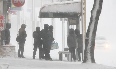
Seoul had the strongest cold wave in 15 years, today's lowest temperature recorded -18.0°C(-0.4°F) this morning.
I know it's pretty impressive for the latitude though why is it seems like always impossible to break more below -18°C point.
Quote:
According to the nation's weather agency, the low in Seoul was minus 18 degrees Celsius, Daegu at minus 13 and Busan at minus 10.2.
Seoul's bone-chilling temperature was the lowest in 15 years and with the wind chill, it felt more like minus 23.6 degrees at noon.
Seoul had the strongest cold wave in 15 years, today's lowest temperature recorded -18.0°C(-0.4°F) this morning.
I know it's pretty impressive for the latitude though why is it seems like always impossible to break more below -18°C point.
That kind of brutal air comes from the NW in Siberia.
Indeed, if you check the weather for the previous day in Harbin, it's a whopping -20/-35C. Moreover, 8 of the last 10 days there have dropped below -30C
Well after this storm it seems we are out of "winter" for the next 2-3 weeks. Tomorrow the average high will have risen up to 52. many of the green trees we got from December are probably gone because of this ice. saw some oaks up in Raleigh with leaves all over them on Tuesday, wonder how they look after the ice storm. lowest temp so far at RDU has been 18, January has been below average but still overall its been a good winter. Spring looks to arrive a bit early this year considering the first half of Feb. is expected to be warm. personally I am just glad we didn't have any serious arctic outbreaks. but when we look at second half of February that's when the effects of the SSW come into play hopefully the PV stays on the other side of the globe and spring stays, not like last year where spring started then second half of Feb. came everything was killed.
Nope, the -PDO will return and La Nina will return with vengeance.
Hope that is correct. La Nina brings interesting weather here.
Quote:
This summer may prove warmer and drier than average according to a study of Midwest weather trends in La Nina summers by Florida State University. Shawn Smith, at the school's Center for Ocean-Atmospheric Prediction Studies (COAPS), says that conclusion is based on June through August temperature/precipitation trends in La Nina summers from 1947-1986. La Nina's most pronounced effects on summer weather may occur in the first part of the season, he adds. The hot, dry summer here in 1988 and the deadly heat wave of July, 1995, both occurred in La Nina periods, but it's not yet possible to accurately predict the occurrence of such extreme effects.
An in-house review of Chicago La Nina summers in 1938, 1950, 1956, 1974, 1988 and 1995, indicates 5 of 6 seasons were warmer than average while 4 of the 6 summers were dry (3 of them 30 to 40 percent off average precipitation levels).
I don't think we will be in a La Nina until the second half of the summer of 2016, or maybe the autumn.
Please register to post and access all features of our very popular forum. It is free and quick. Over $68,000 in prizes has already been given out to active posters on our forum. Additional giveaways are planned.
Detailed information about all U.S. cities, counties, and zip codes on our site: City-data.com.

 Please register to participate in our discussions with 2 million other members - it's free and quick! Some forums can only be seen by registered members. After you create your account, you'll be able to customize options and access all our 15,000 new posts/day with fewer ads.