Please register to participate in our discussions with 2 million other members - it's free and quick! Some forums can only be seen by registered members. After you create your account, you'll be able to customize options and access all our 15,000 new posts/day with fewer ads.
7 day temp change is nothing. Check in a month or two whether the blob is still there which it is.
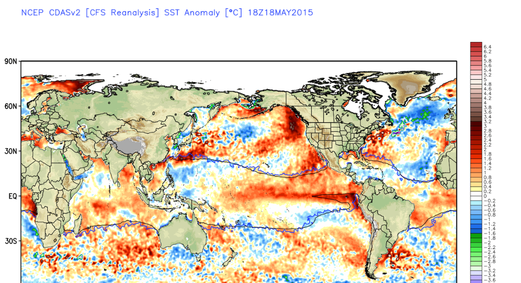
Tell me this has cooled off. Certainly looks warmer than ever to me. And George, you might want to wish for it to stay and get stronger since it was the reason you got the winter you wanted.
I just read this article about what possibly caused the hottest summers of the Dust Bowl
Quote:
Research by Dr Markus Donat from the ARC Centre of Excellence for Climate System Science and colleagues has revealed that unusually warm sea surface temperatures occurring at exactly the same time in two very specific locations were likely responsible for creating the record breaking heat.
“In the Pacific, there were anomalously warm ocean temperatures along the coastline of the Gulf of Alaska stretching down as far as Los Angeles,” said Dr Donat.
“On the other side of the country in the Atlantic Ocean, in a relatively small area off the coast of Maine and Nova Scotia, the ocean surface was also unusually warm. Together they reduced spring rainfall and created perfect conditions for scorching hot temperatures to develop in the heart of the US.”
You do realize that an El Niño would weaken that blob right? Think about it. Why is it currently weakening precisely when Cali is seeing an increase in precip? The reason why that warm blob has been around is because fewer storms have churned up the waters in the North Pacific during a warm PDO with near neutral ENSO conditions. El Niño would theoretically bring more storms into Cali this autumn and winter and thus destroying the blob
Only an eastern based El Nino, the traditional type does what you describe. This one will be central based like the weakling one last year.
Current SST set up in the North Pacific and off the coast of Maine looks similar to that of 1934 and 1936 but it's cooler north of Nova Scotia
wow that's scary! glad the rainfall they are getting now is contrary to those 2 years. for those deniers who believe the pacific water will never cool look at that blue water right off the coast of California. in fact the water is cooler than its been the past few months.
Latest from Jamstec summer 2015.... Not liking this. Looks as if Wisconsin will be above average but Illinois below? Maybe suggesting more rain than normal here?
Guess I could of posted this post here since Summer is starting next week. Good timing with the Calendar and temps. We already had a taste of Summer at the start of May but since then has been Spring Like.
A Temp Prediction:
I'm going for it and calling for extended heat waves in Mid Atlantic Ohio Valley and multiple heat waves in the Northeast. Real feel of triple digit readings in the East. A different feel from last year. This year seems like the SE Ridge has been working out and the heat is easier to spike up.
Soggy summer? Muggy? Lots of mosquitoes? JAMSTEC says yes
Please register to post and access all features of our very popular forum. It is free and quick. Over $68,000 in prizes has already been given out to active posters on our forum. Additional giveaways are planned.
Detailed information about all U.S. cities, counties, and zip codes on our site: City-data.com.

 Please register to participate in our discussions with 2 million other members - it's free and quick! Some forums can only be seen by registered members. After you create your account, you'll be able to customize options and access all our 15,000 new posts/day with fewer ads.