Please register to participate in our discussions with 2 million other members - it's free and quick! Some forums can only be seen by registered members. After you create your account, you'll be able to customize options and access all our 15,000 new posts/day with fewer ads.
I love CAD situations, always interesting to see how it ends up
STRONG 1043 MB HIGH CURRENTLY CENTERED OVER SOUTHERN ONTARIO WILL
HEAD EAST TODAY...SETTING UP A DAMMING SITUATION OVER INLAND
AREAS. AT THE SAME TIME WEAK LOW PRESSURE OVER THE CAROLINA
COAST WILL HEAD NORTH TONIGHT.
ENOUGH COLD AIR WILL BE PROVIDED BY
THE HIGH TO OUR NORTH THAT PRECIPITATION MAY START AS A MIX OF
RAIN AND SNOW ALONG THE COAST AND INTO NYC...BUT SHOULD CHANGE TO
ALL RAIN BY LATE THIS AFTERNOON. THERE MAY BE SOME ICE PELLETS
THAT MIX IN FROM TIME TO TIME.
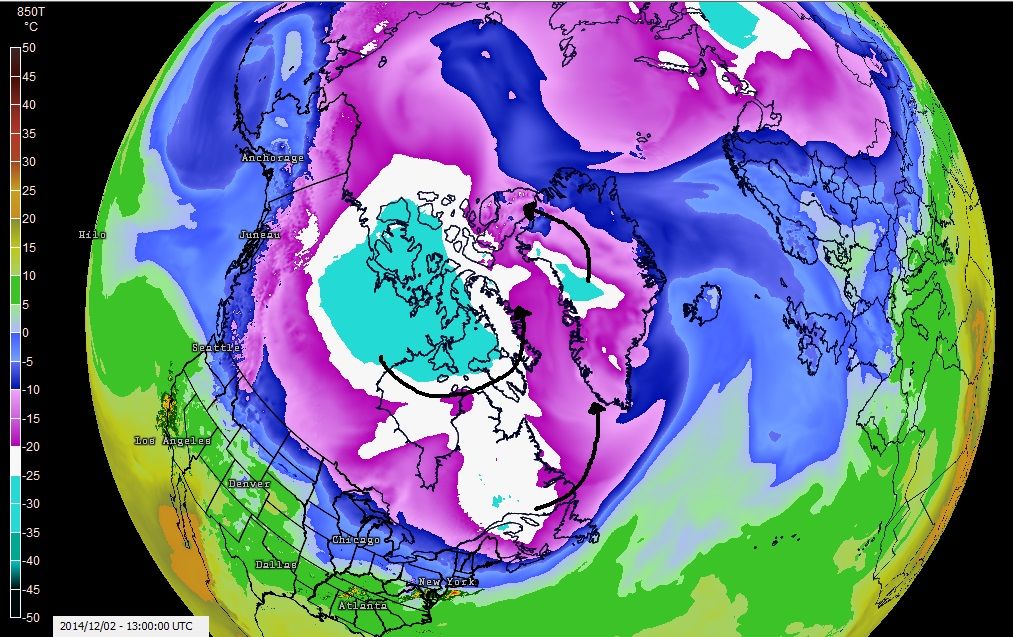
Current 850mb level temps. We all know how the weather moves and curls around but I drew arrows to get a better visual.
First of all... Looks like there is a southeast flow north of Greenland separating the cold air on either side of the Arctic. Interesting cut off!
Second... The -10C line dipped to latitude 47N in Europe. Look for snow and cold in those areas.
Third... If large Lakes or Rivers haven't frozen up in northern Canada they are now. Large area of -20°C or colder that didn't just appear today. It's been there for a while. If the Great Lakes are freezing up with -10C air at this level, no question its looking like the arctic under the whites and blues there. Current temps there are -20 to -30 below zero F°.
Forth... The coldest pool of air (blues) does not drop south more. It basically just spins and curls in that area. The -20C air rotates and sometimes extends out BUT all this air is bottled up in Canada for the next 10 days at least.
U.S WILL NOT have any of this. You can even see how "flat" it is across the U.S with the Pacific flow coming in place.
After mid December is our chance again and I would even go past that with the way the long range GFS is looking past 5 runs!
Last point... if this extreme cold pool of air stays over Canada and builds more naturally, all hell could break loose in January for the U.S if the Vortex drops south more. If that cold pool of air starts shifting to the other side of the Arctic, Game Over. Wont be a cold winter for lower 48. (IMO)
850mb temps & radar. That freezing line aloft will push north throughout the day, that means the 4000 foot layer will be above freezing... watch your surface temps for ice threat! If you are 32 or below at surface and it looks like rain falling, its freezing rain.
I'm predicting a textbook type winter here in the UK, bit of mild weather and a bit of cold though from forecasts I'm predicting more ''cold'' leaning lets hope.. *Fingers crossed*
Quote:
Next week a deep area of low pressure tracking eastwards to the north of the UK is expected to lead to an unsettled picture, especially in the north. As this pulls away colder air could bring an increasing risk of sleet or snow showers to northern regions.
More chilly weather next week, not expecting any ''real'' cold but lets hope temperatures stay in single figures (the 40s)
If that cold pool of air starts shifting to the other side of the Arctic, Game Over. Wont be a cold winter for lower 48. (IMO)
What.... you didn't expect that from me? LOL!!
Here... more support...
While anything past 10 days can easily flip, the last 5 runs of the GFS says forget the cold after this week until the 3rd wk of December.
Not talking about 1 day, talking about a pattern, the flow, consistently cold. Forget it. Depression has begun. I will read the bolded each time though.
This data is for Danbury, CT but you can get a sense of the pattern by looking at the 850mb temps and Freezing height level. DOES not look like a cold pattern after this week!
Current 850mb level temps. We all know how the weather moves and curls around but I drew arrows to get a better visual.
First of all... Looks like there is a southeast flow north of Greenland separating the cold air on either side of the Arctic. Interesting cut off!
Second... The -10C line dipped to latitude 47N in Europe. Look for snow and cold in those areas.
Third... If large Lakes or Rivers haven't frozen up in northern Canada they are now. Large area of -20°C or colder that didn't just appear today. It's been there for a while. If the Great Lakes are freezing up with -10C air at this level, no question its looking like the arctic under the whites and blues there. Current temps there are -20 to -30 below zero F°.
Forth... The coldest pool of air (blues) does not drop south more. It basically just spins and curls in that area. The -20C air rotates and sometimes extends out BUT all this air is bottled up in Canada for the next 10 days at least.
U.S WILL NOT have any of this. You can even see how "flat" it is across the U.S with the Pacific flow coming in place.
After mid December is our chance again and I would even go past that with the way the long range GFS is looking past 5 runs!
Last point... if this extreme cold pool of air stays over Canada and builds more naturally, all hell could break loose in January for the U.S if the Vortex drops south more. If that cold pool of air starts shifting to the other side of the Arctic, Game Over. Wont be a cold winter for lower 48. (IMO)
Timing, Timing, Timing.
I'm not an extreme cold weather fan, but I have to say these up and down temps drive me nuts. Yesterday morning I left for work it was in the low 60'sF. I wore a light coat. When I left work last night I was really cold with the rain and 40'F temps. I'd rather have sunny and cold to tell you the truth with no wind. A 30-35F sunny winter day here without wind is actually refreshing and quite tolerable.
I've yet to read a blog from any meteo that thinks this winter will be mild. All the signals point to colder than average. I think your scenario for January is on target. The cold air will be stored up and be very cold by then, and it will be unleashed on the eastern US (almost never goes west). The only thing we don't know yet is which area it will hit the most. AccuW long range into mid January shows Philly below average just about every day the first half of the month.
Last point... if this extreme cold pool of air stays over Canada and builds more naturally, all hell could break loose in January for the U.S if the Vortex drops south more. If that cold pool of air starts shifting to the other side of the Arctic, Game Over. Wont be a cold winter for lower 48. (IMO)
Timing, Timing, Timing.
IMO, I think you're right on this except I think the cold pool will stay north. The way the pattern has evolved thus far I think we will continue to maintain this warmer pattern for a while. While I am hoping this isn't the case, I'd bet on it.
I think for the SW Missouri area we will see an "average" winter. With that being said, it might end up being more icy than snowy; which is terrible. I love cold and winter snow, absolutely dislike ice. There is concern that Wednesday Night/Thursday there could be freezing drizzle.
Looks like winter precipitation will start around 6 or 7? Start as snow then turn to freezing rain. Would like to be off the road before it starts, especially the freezing rain.
Please register to post and access all features of our very popular forum. It is free and quick. Over $68,000 in prizes has already been given out to active posters on our forum. Additional giveaways are planned.
Detailed information about all U.S. cities, counties, and zip codes on our site: City-data.com.

 Please register to participate in our discussions with 2 million other members - it's free and quick! Some forums can only be seen by registered members. After you create your account, you'll be able to customize options and access all our 15,000 new posts/day with fewer ads.