Please register to participate in our discussions with 2 million other members - it's free and quick! Some forums can only be seen by registered members. After you create your account, you'll be able to customize options and access all our 15,000 new posts/day with fewer ads.
If you have been following Andrew, he has been saying this for weeks on end. Nothing new to see here.
From Andrew's blog:
Something I've discussed on here more than a few times is the concept of the Lezak Recurring Cycle, or LRC. The LRC was developed by meteorologist Gary Lezak, and discusses the idea that weather patterns which develop in October leave a 'footprint' of sorts that is repeated in a regular interval, between 40-60 days through the winter and following spring. In other words, the weather patterns that develop in October repeat themselves for the better chunk of the next year. Since mid-September, we've seen predominantly below-normal temperatures for large swaths of the Central and East US.
George, seriously, do you honestly believe the bolded statement by Andrew?
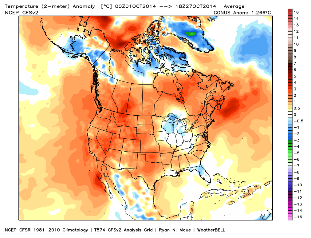
Look at the graphics below, and tell me if you think he is being honest here. If anything temps have gotten warmer since mid September not colder. I know we have.
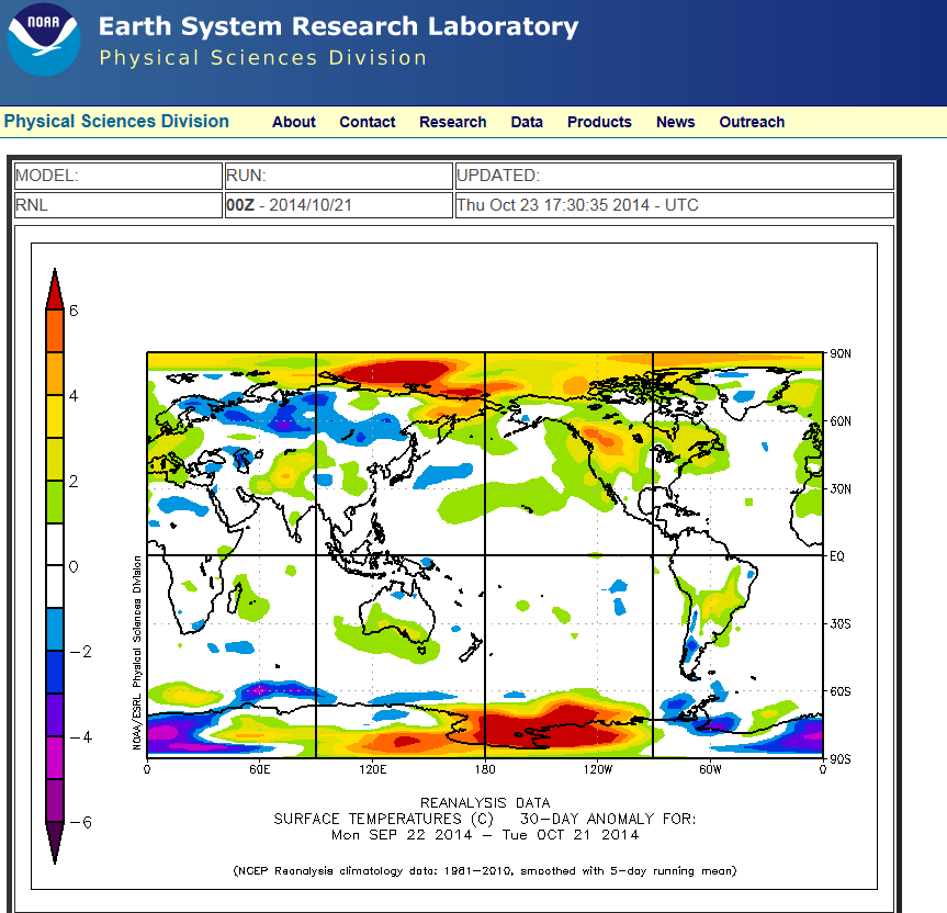
And here is the anomaly for the last 30 days, which includes from September 22nd. Andrew is a cold fanatic. He makes no bones about it. I even checked his forecasts from 2011, and he couldn't even then bring himself to admit that a very warm winter was coming. I need to find a truly unbiased weather blogger, cause if you ask me, every single winter weather blogger in the US is a hard core cold weather fan.
I will predict a normal winter for the Chicago winter with periods of cold\snow\and warmer\colder wheather than average with periods of above average precipitation ( It will be cold and we will get 30-40 inches of snow)
If you have been following Andrew, he has been saying this for weeks on end. Nothing new to see here.
From Andrew's blog:
Something I've discussed on here more than a few times is the concept of the Lezak Recurring Cycle, or LRC. The LRC was developed by meteorologist Gary Lezak, and discusses the idea that weather patterns which develop in October leave a 'footprint' of sorts that is repeated in a regular interval, between 40-60 days through the winter and following spring. In other words, the weather patterns that develop in October repeat themselves for the better chunk of the next year. Since mid-September, we've seen predominantly below-normal temperatures for large swaths of the Central and East US.
George, seriously, do you honestly believe the bolded statement by Andrew?
Well "large swaths" of the Central and East US have not been below average since mid September. I don't understand how anyone can make that assertion. We here HAVE been below average, but not large swaths of the region.
We have been below average since the end of August
Still, he presents some enlightening information, analogs, and graphs.
In the end, Joe Bastardi (always a cold lover), is my go to guy for seasonal forecast because he has a good track record.
Hey, I think it's gonna be a bit colder and a bit snowier in Chicagoland!
WHO CARES, LAST YEAR WAS very rough on all the cold and snow haters!!! if its set for a real nasty winter again there betterbe a sh#$ load of the white stuff falling or I will be so p#$sed off!
Why won’t Winter 2014/15 be as mild and stormy like winter 2013/14? Well let’s first look at why the 2013/14 winter turned out so persistently wet and windy. There have been strong suggestions that persistent Indonesian rainfall had a huge impact on the Pacific jet stream, causing the jet to buckle and allowing a dominant high-pressure system to reside just off the Northwest coast of America and Canada. This in turn started to drag very cold air from the Arctic, filtering down the eastern side of the USA and plunging these areas into a very cold and bitter winter. Due to the eastern USA being unusually bitter, the cold temperatures caused a huge temperature contrast between the warm flow of the Atlantic Ocean (via the Gulf Stream) and the cold air mass filtering out of the USA. This contrast was partly responsible, along with an unusually strong QBO (Quasi-biennial oscillation) for a strengthening of the jet stream, which in turn strengthened the low pressures systems that affected the United Kingdom. The QBO also produced a very strong polar vortex, which despite many attacks, stood firm and continued to push very cold air into the Eastern United States. Now this winter the QBO will be in a different phase to start with, which supports an overall less potent stratospheric vortex. Another factor will be the Indian Dipole, albeit indirectly. The Indian dipole is an irregular oscillation of sea surface temperatures in which the western Indian Ocean becomes alternately warmer and then colder than the eastern part of the ocean. During a positive phase of the Indian Dipole, conditions around Indonesia are significantly drier than normal. During this winter the Dipole will continue in a positive phase, so there will be no repeat of the Indonesian rains that cause such a dramatic and lengthy shift in the pacific jet. So we leave you with that for now, we hope you enjoyed all the information supplied and don’t forget we will be producing further updates when necessary. - See more at: UK Winter 2014/15 Weather Forecast - UK Weather Forecast
latest cfs is going for a very warm winter for most parts of northern europe.
How frustrating
Please register to post and access all features of our very popular forum. It is free and quick. Over $68,000 in prizes has already been given out to active posters on our forum. Additional giveaways are planned.
Detailed information about all U.S. cities, counties, and zip codes on our site: City-data.com.

 Please register to participate in our discussions with 2 million other members - it's free and quick! Some forums can only be seen by registered members. After you create your account, you'll be able to customize options and access all our 15,000 new posts/day with fewer ads.