Welcome to City-Data.com Forum!
U.S. CitiesCity-Data Forum Index
Go Back   City-Data Forum > General Forums > Weather
 [Register]
Please register to participate in our discussions with 2 million other members - it's free and quick! Some forums can only be seen by registered members. After you create your account, you'll be able to customize options and access all our 15,000 new posts/day with fewer ads.
View detailed profile (Advanced) or search
site with Google Custom Search

Search Forums  (Advanced)
 
Old 04-29-2014, 06:07 AM
 
29,590 posts, read 19,793,403 times
Reputation: 4573

Advertisements


What a lovely week. Other than today (high of 20C), temps below average and gloomy. Not a particularly nice way to start the month of May


But believe it or not April will end up just about average in Chicago. Maybe a touch above in maximum temps and a touch below in the Mean.
Reply With Quote Quick reply to this message

 
Old 04-29-2014, 06:39 AM
 
Location: Near the Coast SWCT
83,711 posts, read 76,196,004 times
Reputation: 16725
We could be 15-20 degrees warmer on Thursday compared to tomorrow's max.

Mid 70s up to Hudson Valley Thursday.

Reply With Quote Quick reply to this message
 
Old 04-29-2014, 06:51 AM
 
29,590 posts, read 19,793,403 times
Reputation: 4573
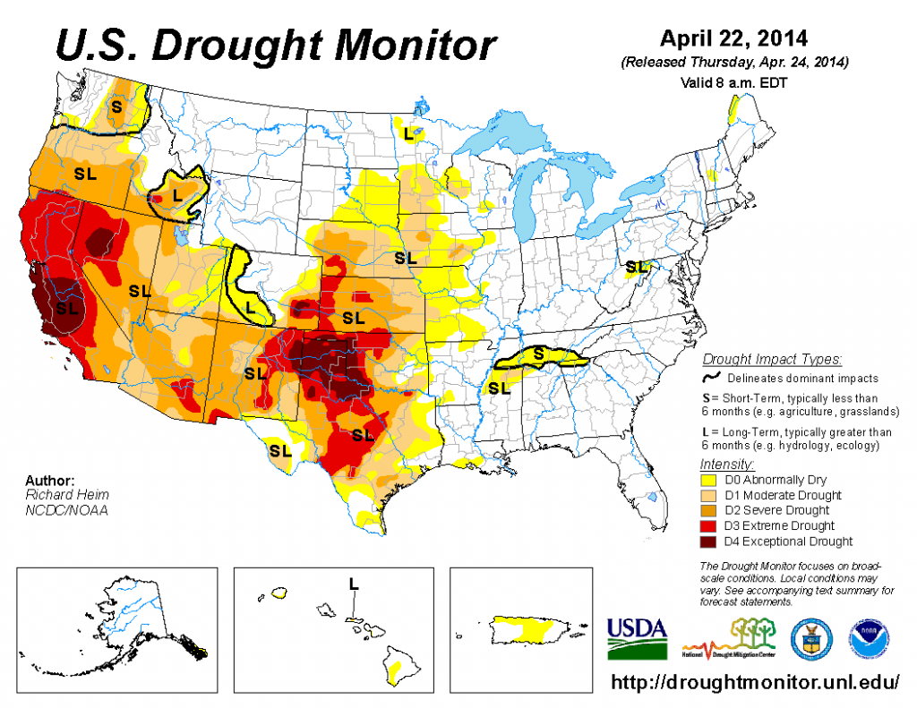
Just saw the drought monitor. I wonder if there will be changes to this map after this week's storm event?


On the other hand, it seems as if most of the substantial rains fell outside the impacted areas (I think). If that's the case, I can see how Cliff Harris maybe right as a drought ridden Central Plains will help induce a ridge over the Central US this summer. But anything can happen and I believe the CPC is calling for an easing of drought conditions for the Central US by the summer. Let see if they are right.
Reply With Quote Quick reply to this message
 
Old 04-29-2014, 07:01 AM
nei nei won $500 in our forum's Most Engaging Poster Contest - Thirteenth Edition (Jan-Feb 2015). 

Over $104,000 in prizes has already been given out to active posters on our forum and additional contests are planned
 
Location: Western Massachusetts
45,983 posts, read 53,803,449 times
Reputation: 15184
I'd guess the induced ridge wouldn't be strong enough to impact New England?
Reply With Quote Quick reply to this message
 
Old 04-29-2014, 07:07 AM
 
Location: Lexington, KY
12,278 posts, read 9,509,620 times
Reputation: 2763
Yay 2 inches of cold rain so far
Reply With Quote Quick reply to this message
 
Old 04-29-2014, 08:31 AM
 
Location: Near the Coast SWCT
83,711 posts, read 76,196,004 times
Reputation: 16725
Some snowfall reports from South Dakota. About 4:1 Ratios in spots! (heavy wet snow!)

Looks like some areas got 6-12" in South and North Dakota.

http://www.srh.noaa.gov/ridge2/snow/index.php?site=pub

NWS Bismarck, ND Home Page

NWS Rapid City, SD


South Dakota

twitter.com/shawncable/status/461133706594250752


"Moderate snow continues in along the ND/SD border. DOT cam near Herreid, SD on US-83"
twitter.com/AaronWhiteWDAY/status/461138961662869504

Reply With Quote Quick reply to this message
 
Old 04-29-2014, 08:37 AM
 
Location: Near the Coast SWCT
83,711 posts, read 76,196,004 times
Reputation: 16725
Current Map.. Looks like Nebraska in the snow action too. Little Dust storms happening in Texas and Colorado

30s in Kansas this morning

Reply With Quote Quick reply to this message
 
Old 04-29-2014, 10:15 AM
 
Location: Near the Coast SWCT
83,711 posts, read 76,196,004 times
Reputation: 16725
This great Satellite image strengthens my point a bit further. How a Tornado of the past all it did was just scrape the landscape of Earth, but now unfortunately with population and more structures going up in any area, we see worse results and human impact.

They've always happened, they were always strong, we're just more in the way now and thankfully with technology we can see them better and warn people better. My point is similar with tsunamis. In the past all they did was bring water onto land and change the landscape. But when population decides to live on the coast we hear and see the damage/impacts more from it..

From Tom Nizol.

"Here is a before and after image from the NASA MODIS polar orbiter satellite showing what appears to be the scar from the tornado that ripped through Vilonia Arkansas Sunday. Vilonia is near the point of the arrow on the right. This is a 250m resolution image"

Reply With Quote Quick reply to this message
 
Old 04-29-2014, 10:24 AM
 
Location: Lexington, KY
12,278 posts, read 9,509,620 times
Reputation: 2763
Perfect day! Mid 70s with sun currently, 66% humidity.
Reply With Quote Quick reply to this message
 
Old 04-29-2014, 10:58 AM
 
Location: Near the Coast SWCT
83,711 posts, read 76,196,004 times
Reputation: 16725
Quote:
Originally Posted by G8RCAT View Post
Perfect day! Mid 70s with sun currently, 66% humidity.
We're both getting what we like today. 47℉/8C here midday. Feels like 43F/6C with the wind. Overcast. Normal max is low 60s. Feels like winter. Folks and myself got the fireplaces/wood stoves on.

Storms firing up on south side of warm front in Gulf. Its the start of the Tornadoes later.
Reply With Quote Quick reply to this message
Please register to post and access all features of our very popular forum. It is free and quick. Over $68,000 in prizes has already been given out to active posters on our forum. Additional giveaways are planned.

Detailed information about all U.S. cities, counties, and zip codes on our site: City-data.com.


Reply
Please update this thread with any new information or opinions. This open thread is still read by thousands of people, so we encourage all additional points of view.

Quick Reply
Message:


Over $104,000 in prizes was already given out to active posters on our forum and additional giveaways are planned!

Go Back   City-Data Forum > General Forums > Weather

All times are GMT -6.

© 2005-2024, Advameg, Inc. · Please obey Forum Rules · Terms of Use and Privacy Policy · Bug Bounty

City-Data.com - Contact Us - Archive 1, 2, 3, 4, 5, 6, 7, 8, 9, 10, 11, 12, 13, 14, 15, 16, 17, 18, 19, 20, 21, 22, 23, 24, 25, 26, 27, 28, 29, 30, 31, 32, 33, 34, 35, 36, 37 - Top