Please register to participate in our discussions with 2 million other members - it's free and quick! Some forums can only be seen by registered members. After you create your account, you'll be able to customize options and access all our 15,000 new posts/day with fewer ads.
This is one long winter for sure. It hasn't stopped snowing since last evening when I saw it begin again around 5pm. Haven't seen many plows go by today. I think they gave up until this blows over since they aren't getting ahead at all. One good thing is the temp has risen to 0.5 F. I'll take that half a degree.
Does Antrim county or Otsego county average more snowfall annually or are they both about the same?
I looked at the northern Michigan NWS and it stated that Gaylord has received over 125 inches of snowfall so far this season and that is where the office is.
Temperatures on target to set record – Wind Chill Warning continues
Quote:
Temperatures are falling rapidly this evening under clear skies and a fresh snow cover. Readings at 9PM CST had reached double-digits below zero at a few locations – the lowest being a -10 degrees at DeKalb – followed closely by -9 at Rockford, Rochelle, and Waukegan. At the official O’Hare observation site the reading was a -6, just 7 degrees shy of the record -13 degree low for January 28th set back in 1977. Minimum temperatures are normally reached in the pre-dawn hours, so it’s likely we will establish a new record low – perhaps by several degrees.
Temperatures are still expected to bottom out at close to 10 below in the city (it’s already a -4 at the Northerly Island lakefront location), and closer to -20 degrees or even lower in locations along and beyond the Fox River Valley.
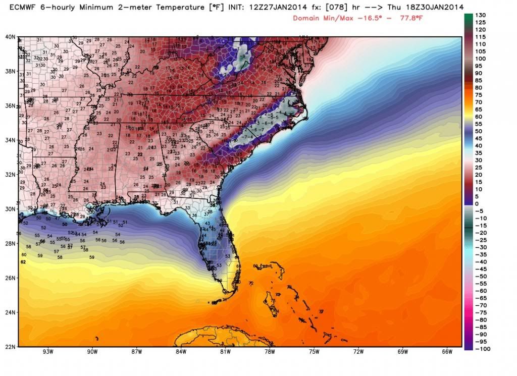
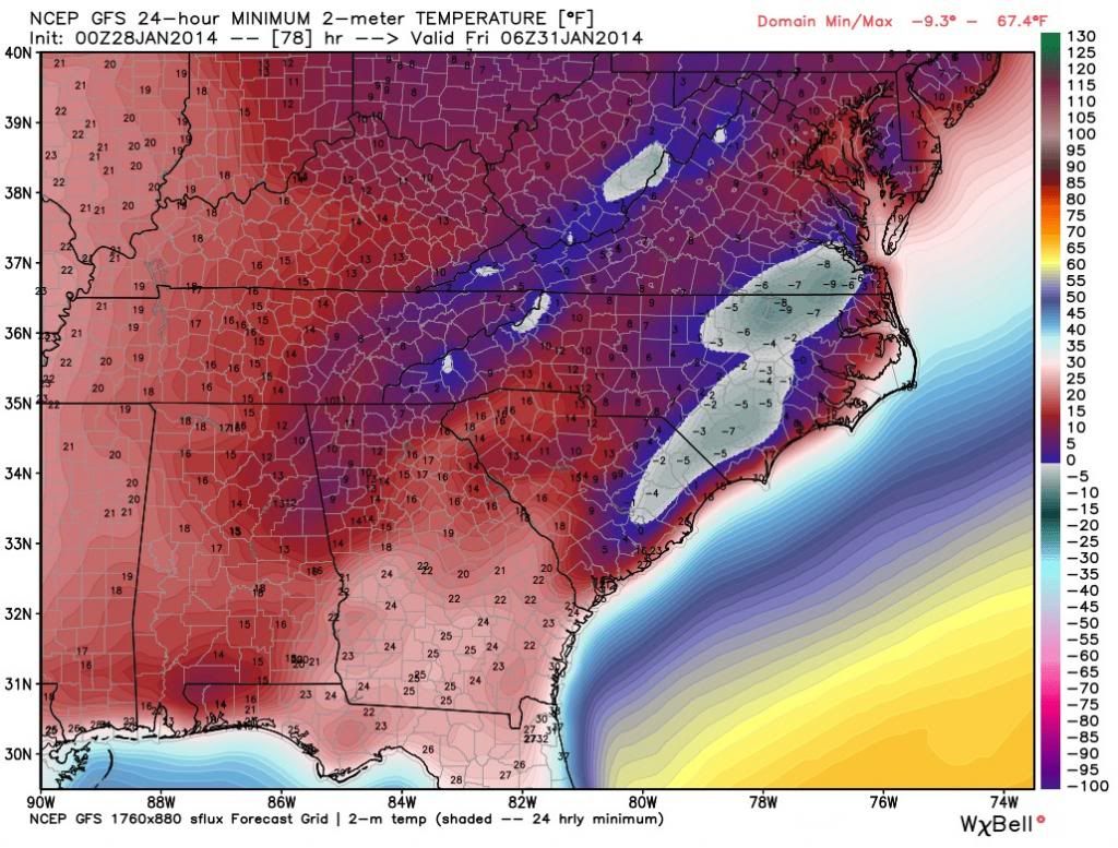
So what are the odd these model output temps are actually reached. It would smash a lot of records that is for sure. Philly with a model low temp of 7F, and Fayetteville NC with a low of -7F.
Ok.. lets do this again. Feels like once a month I've been looking at some stuff and trying to grasp the long range. Lets see if I can go 3 for 3.
That's not what I'm thinking right now... Ridge should stay out west and that will carve a trough in center and eastern part of the U.S and the sub jet will come back to life . So I think Jan 20 to end of February becomes active again with the Jan26-Feb15 period the peak).
Not bad, but not over either. Thanks to the GFS for helping me out a little bit past 10 days. Clipper after Clipper, Shortwave after shortwave we been having past 7 days.
I plan on doing a new thought within a week regarding past mid February into March. For now any warmup that was being shown has been gone. So we stay status quo for over a week still. Another arctic blast or 2 in February.
I have to remind myself that averages start to go up now so 20s in January would equate to 30s in March.
And Look whats showing up again right on cue. Get ready for more active weather next 2 weeks with snow/ice/rain East of the Mississippi..
-3F at 6:30 AM here. Steady 10 mph winds, nothing like the gusts yesterday that blew the snow into mini snowspouts, it looked like tiny snow tornadoes all over.
The extreme drought resulting in fires in Central Norway: Busfires not just smallish. In Flatanger, some 200 km northwest of Trondheim, about 100 buildings have burned down, as a peninsula is engulfed in the fire. The fire is spreading in the undergrowth, which is extremely dry. - 139 bygninger i fare for å brenne ned -adressa.no
Please register to post and access all features of our very popular forum. It is free and quick. Over $68,000 in prizes has already been given out to active posters on our forum. Additional giveaways are planned.
Detailed information about all U.S. cities, counties, and zip codes on our site: City-data.com.

 Please register to participate in our discussions with 2 million other members - it's free and quick! Some forums can only be seen by registered members. After you create your account, you'll be able to customize options and access all our 15,000 new posts/day with fewer ads.