Please register to participate in our discussions with 2 million other members - it's free and quick! Some forums can only be seen by registered members. After you create your account, you'll be able to customize options and access all our 15,000 new posts/day with fewer ads.
There is a saying "if there's ice in November that will bear a duck, there'll be nothing thereafter but sludge and muck" which is supposed to mean what you're saying about early snowfall indicating a mild/short winter.
I looked at the NWS OKX site, which has Central Park snowfall data (NYC Central Park Monthly Snowfall) and the years that had sticking snowfall in Oct. (1876, 1925 and 1952) show some interesting stuff. 1876 ended up "above normal" (40"), 1925 "about normal" (32") and 1952 "below normal" (15"). So on that can't tell....
I also looked at 1962 (T at CPK but measurable at LaGuardia and Kennedy), "below normal" (16"), 1979 (almost everywhere but NYC itself got sticking snow), very "below normal" (12"), and 1987 (sticking snow in most of Fairfield and the upper 2/3 of Westchester), again "below normal" (19").
So maybe there is something to the saying...... Just to add one more, 1989 (the Thanksgiving snowstorm) was a "below normal" year too (13")
Dr. Mel …the long time Connecticut meteorologist on Channel 8 used to look for colder than normal Octobers and Novembers has a trend for the 3 months of winter. He used to say (though I don’t know how much science was behind it) that colder than normal Oct and/or November more than 75% of the time followed all the coldest winters – but many warm winters also had colder than normal Oct/Nov as well.
This October was well above normal at most NWS stations in the Tri-State area, so perhaps the dusting of snow some areas this weekend really doesn’t mean much in what Dec/Jan/Feb will bring. This week looks sunny with temps in the 55 to near 60 F range and nights in the 30's and 40's (close to climo). So, I guess we'll find out soon.
So Mr. Climate..and I mean this in a complimentary way as you do seem to have a good grip on local climatology up there...why did it snow all the way to the coast with such warm water temps?? I thought according to you this was almost impossible.
If anyone wants details of why it happened this should explain it all. From the same guy who said "No snow under 500 feet"... Dont underestimate the air temp just a couple thousand feet above us.. there's not enough room for it all to melt sometimes and then the rate of intensity helps accumulate.
Just in case you cant read it all I'll take a bit from it.
"Basically, the rising motion of air in the atmosphere is what caused the rapid cooling of temperatures from 44 degrees to 33 degrees in a matter of a few hours" warmer air at this level is forced to rise up and over the colder air in place."
"from the surface to the mid levels, This is where the unique nature of this storm really is revealed. In this unique case, the rising motion of the air from the surface to 850 MB(5000') was extremely strong. That rising motion of the air developed due to the much warmer air at the surface able to rise up into the much colder environment at the mid levels from 925 MB(2000') to 700 MB(8000').
This nature of the atmosphere lead an intense mid level lapse rate, which helped to rapidly cool the atmosphere at the surface in a short period of time by six to ten degrees Fahrenheit. How do we know that the instability in the atmosphere existed? Because of the thunder-snow that was reported in New York City at around 3 PM that afternoon. Elevated thunderstorms in these types of storms do not develop unless a strong mid level instability factor is present."
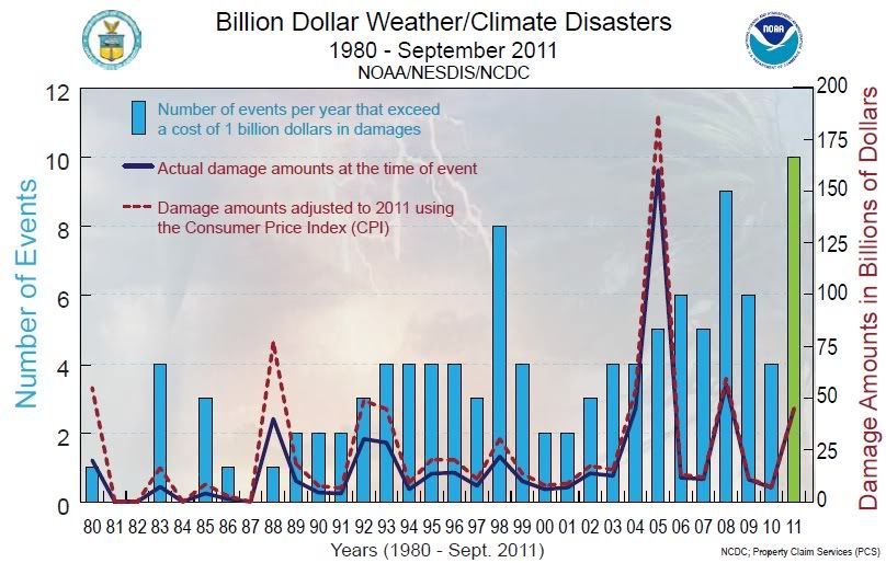
Billion Dollar Disasters on the rise. This Graph shows 10 events this year alone and the October 29th snowstorm would make it 11th if there's a billion dollars worth of damage. This is for the U.S only.
Economic damage costs to date in the US exceed $45 Billion.
Hurricane Irene, August 20-29, 2011
Upper Midwest Flooding, Summer, 2011
Mississippi River flooding, Spring-Summer, 2011
Southern Plains/Southwest Drought, Heatwave, & Wildfires, Spring-Summer, 2011
Midwest/Southeast Tornadoes, May 22-27, 2011
Southeast/Ohio Valley/Midwest Tornadoes, April 25-30, 2011
Midwest/Southeast Tornadoes, April 14-16, 2011
Southeast/Midwest Tornadoes, April 8-11, 2011
Midwest/Southeast Tornadoes, April 4-5, 2011
Groundhog Day Blizzard, Jan 29-Feb 3, 2011
So Mr. Climate..and I mean this in a complimentary way as you do seem to have a good grip on local climatology up there...why did it snow all the way to the coast with such warm water temps?? I thought according to you this was almost impossible.
The link that Cam provided explains the “meteorology” behind this unique event pretty well I think. I don’t think that I ever said snow was “impossible” down on the coastal plain when SST were high – only the probability of such events is very, very low. You read several of the links above – they all reiterated how rare accumulating snow is along the coastal plain of the Tri-State area before early December.
My issue is (and always will be)...that weather today is so marketed, so full of hype, spin, bias forecasting...etc, that the true nature of the local climate (any local climate) is often lost. Worse - the long term odds of sensible weather events is totally misrepresented. Just use winter in the metro East Coast for example: each winter from early November to early April - weather forecasters and media outlets on the East Coast try to spin up every storm, every low pressure area, into a 20 inch snowstorm for the big cities. Yet the long term data sees to show something different; every single NWS station on the Atlantic coastal plain from New London, Connecticut to Virginia Beach, VA averages only 10 to 25 inches of snow annually. If 20 inche snowstorms were that common on the coastal plain of the Tri-State/metro East Coast, the long term data would look much different. Compare this with the 60 to 90 inches that stations in the Great Lakes (Cleveland, Duluth, Buffalo...etc)....the 70 to 110 inches stations in New England get (Concord, Portland, Burlington...etc)...and the 100 to 300 inches many stations in the Western states get...and it makes little sense. Look at the hype of getting a snowstorm (defined as 6 inches or greater) in the coastal plain of the East Coast both in early and late season. Do you have any idea the long terms odds of a snowstorm in NYC, Bridgeport, Trenton, Wilmington, De, Washington Dc...etc in November, April, or even late March and early December are?
You mark my words...most of the Tri-State/Mid Atlantic will likely not see a significant snowfall until late December (just like last year)...yet for the next two months every single low pressure area will be spun for its maximum market value, using this early dusting of snow as the gear for hype.
It’s enough to make an old climatologist cry (lol).
Well I think you are right about the overblowing of every potential storm. Its been bad anyway in the media, it will get worse. I wouldn't call this a dusting of snow though. This was a bonafide storm that affected many people. It may have been unique and as you say very rare but what was ironic was it deserved its billing.
Well I think you are right about the overblowing of every potential storm. Its been bad anyway in the media, it will get worse. I wouldn't call this a dusting of snow though. This was a bonafide storm that affected many people. It may have been unique and as you say very rare but what was ironic was it deserved its billing.
Agree with this statement. Personally I was woefully unprepared for this storm...mentally and materially...because I was pooh-poohing the possibility of snow accumulating while the ground was so warm. And yet...this storm was under-hyped compared to some of the ones in the past year (Dec 27th storm, Irene come to mind).
Having been hard hit by this one, will definitely pay more heed, and spring for a generator going forward.
Yea Wavehunter wants to get his "dusting of snow " dig in. He just cant help himself. .But thats an insult to every person who's power is out because of the massive snow ..totally insensitive. Honestly when I get up there I am not buying a generator..these storms are fluky in nature. I lived there my whole life and power never went out.
Nothing to report thankfully...all looks normal in the near future. rain showers, 50s, maybe a 60s, lows in 40s... Next rainstorm would be around November 9th but right now nothing big. There's actually a coastal storm going OTS on Tuesday... PHEW!! Lets hope the snow melts so we can enjoy Autumn.
Quiet and normal for another week which is perfect for the disaster recovery process.
Should warm up nicely to near 60 but lows still dropping to 30s/40s.
Something still showing up on the 9th (Rain to snow(interior))
But starting mid month things get very active again and NAO is going negative so that means coastal storms are possible.
Yea Wavehunter wants to get his "dusting of snow " dig in. He just cant help himself. .But thats an insult to every person who's power is out because of the massive snow ..totally insensitive. Honestly when I get up there I am not buying a generator..these storms are fluky in nature. I lived there my whole life and power never went out.
…and see, that’s exactly what I’m talking about ‘massive snow” really?
NWS Central Park received 2.9 inches…NWS JFK received 1.5 inches….NWS Bridgeport received 3.9 inches…NL/Groton 0.3 inches…NWS Islip 0.3 inches…NWS Windsor Locks, CT got a trace (T)….and I got 0.5 inches that was 100% melted by noon. Yea, it was “massive alright”. As of today - there was not a single trace of snow left in 99% of CT/NYC/NJ. Here is the traffic cams…see if you can find a shot with snow on the ground (lol):
Calling that massive is the real insult to the people who live in the snowbelts up in the Great Lakes, Mt West, Northern New England, CA…etc, and get 100 to 300 inches of snow EVERY winter. They must be having a good chuckle at our “massive storm” the gods of media and marketing concocted.
Hype on....
Please register to post and access all features of our very popular forum. It is free and quick. Over $68,000 in prizes has already been given out to active posters on our forum. Additional giveaways are planned.
Detailed information about all U.S. cities, counties, and zip codes on our site: City-data.com.

 Please register to participate in our discussions with 2 million other members - it's free and quick! Some forums can only be seen by registered members. After you create your account, you'll be able to customize options and access all our 15,000 new posts/day with fewer ads.

 Just to add one more, 1989 (the Thanksgiving snowstorm) was a "below normal" year too (13")