Spring 2018 Thread - Northern Hemisphere (warm, rainfall, days, storms)
Please register to participate in our discussions with 2 million other members - it's free and quick! Some forums can only be seen by registered members. After you create your account, you'll be able to customize options and access all our 15,000 new posts/day with fewer ads.
Saguenay is the hottest place in Canada right now at 32°C and 6:30 pm, can't happen often. Normally it's either Ontario or western Canada. NYC reached 20°C with a dewpoint of 19°C (66°F, a few degrees less on Long Island), Quebec City 32°C with a dewpoint of 14°C, both at 5 pm
the strange pattern giving heat up north and cool here. 500 hPa, no low visible over the Northeast but Quebec has a warm airmass. from tropicaltidbits.com
850 hPa show a cool spot, but clouds are making the difference bigger at the surface
definitely not a cut-off low. High pressure is stalling a front over us. Ridge isn't obvious from the surface map
and the clouds from NOAA Goes
I think Alberto dragged a front over and it stalled. Next week it will be from the low.
Been misting and raining here for 4 hrs now. Up to 0.10" today. Over 3" for the month.
Wet roads. Wet shoes. Used wipers every other day on average.
Including today...at Bridgeport..
April 1-May 31
27 days with measurable rain.
Most since 2005.
Only 6 yrs had more. (1950, 2004, 2000, 2005, 1966, 1956)
So basically we havent had this many rainy days for April & May in over 10 yrs. I knew it felt odd.
I was happy with my local weather for Apr and May. Had 4" in Apr and almost 8" in May. now we are gonna see how dry June is gonna be. Last few Junes and Julys have been very dry for me.
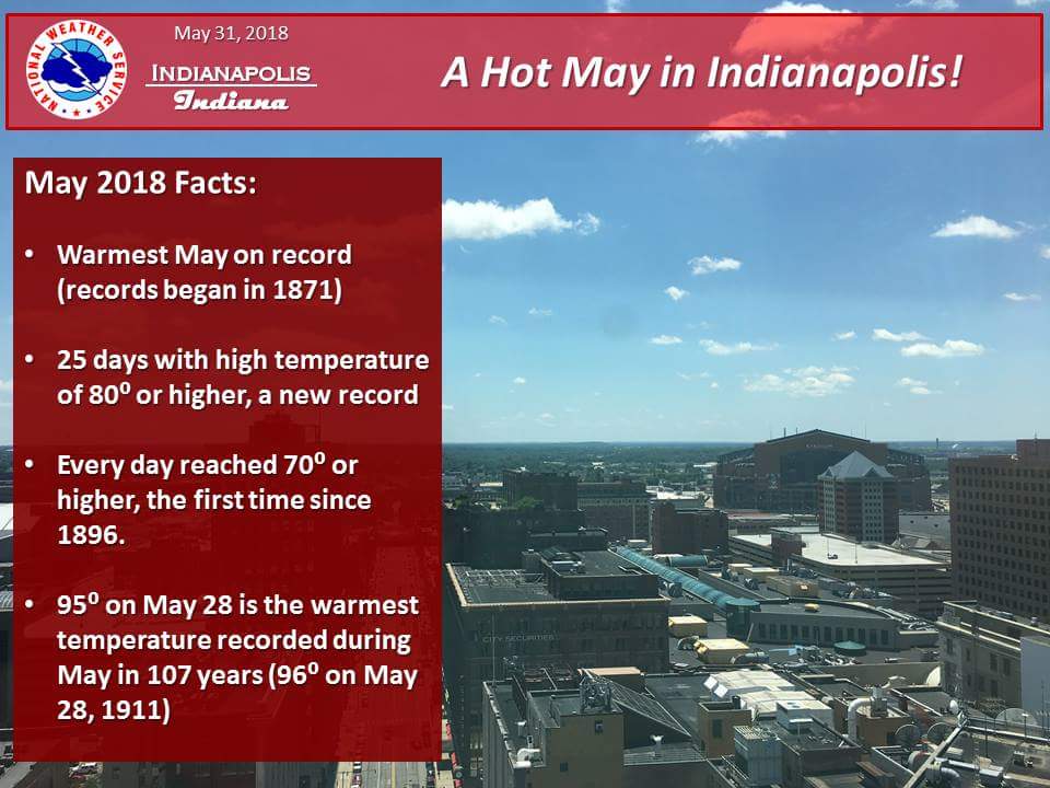
Warmest May on modern record in Indianapolis, it looks virtually certain that not only is it going to be the warmest on record, but that the old record warm May in 1896 will be shattered by around 1.5 F, I am predicting a monthly mean temperature of around 72.5 F for the month of May in Indianapolis, which if this comes to fruition, would be closer to the average monthly temperature for the month of June (72.0 F), so this year we essentially skipped May and went straight into summer.
Max temps for the Last day of Spring. See you all in the Summer Thread.
Update for my backyard and area....
May 12: Overcast morning and all day. Evening Rain. 0 Hours of sun
May 13: Overcast morning and all day. Mist & Drizzle. 0 Hours of sun
May 14: Overcast morning then sun 3-7pm. 4 Hours of sun
May 15: Overcast morning then in/out sun 12-4pm. 2 Hours of sun
May 16: Overcast morning and cloudy all day. Rain 11am & all day. 0 Hours of sun
May 17: Overcast morning and cloudy all day. Morning rain. 0 Hours of sun
May 18: Overcast morning, cloudy all day except for pokes of sun. 1 Hours of sun
May 19: Overcast morning and cloudy all day. Rain & Mist all day. 0 Hours of sun
May 20: Overcast morning then in/out sun 11-3pm. Pop up shower in afternoon. 2 Hours of sun
May 21: Sunny Morning and all day. 12 Hours of sun
May 22: Overcast morning and all day. Rain & Mist 1pm through evening. 0 Hours of sun
May 23: Overcast morning then sun 12-7pm. 7 Hours of sun.
May 24: Sunny morning and all day. 13 hours of sun.
May 25: Sunny morning and all day. 13 hours of sun.
May 26: Sunny morning then cloudy after 12pm. 5 hours of sun.
May 27: Overcast morning and all day. Morning rain, mist rest of day. 0 Hours of sun
May 28: Overcast morning and cloudy all day. 0 Hours of sun
May 29: Overcast morning then Sun and Haze after 10am. 8 Hours of sun
May 30: Overcast/Foggy Morning then sun after 11am. 7 Hours of Sun.
May 31: Overcast morning and all day then mist and rain after 1pm. 0 Hours of Sun.
June 1: Overcast/Foggy morning. Drizzle in morning.
Only 74 hours (3 days) of sun in last 492 hours (20.5 days)!
Please register to post and access all features of our very popular forum. It is free and quick. Over $68,000 in prizes has already been given out to active posters on our forum. Additional giveaways are planned.
Detailed information about all U.S. cities, counties, and zip codes on our site: City-data.com.

 Please register to participate in our discussions with 2 million other members - it's free and quick! Some forums can only be seen by registered members. After you create your account, you'll be able to customize options and access all our 15,000 new posts/day with fewer ads.


 Lots of unpredictable weather, wide temperature variances and snow.
 .
.