Spring 2018 Thread - Northern Hemisphere (hot, records, Chicago, days)
Please register to participate in our discussions with 2 million other members - it's free and quick! Some forums can only be seen by registered members. After you create your account, you'll be able to customize options and access all our 15,000 new posts/day with fewer ads.
Quick update: 3rd morning in a row with clouds again. Crazy how these fronts are stalling. Was hoping we didn't get another crappy May again.
You can definitely see the struggle in the garden.
May 12: Overcast morning and all day. 0 Hours of sun
May 13: Overcast morning and all day. 0 Hours of sun
May 14: Overcast morning. 4 Hours of sun
May 15: Overcast morning. 2 Hours of sun
May 16: Overcast morning and all day. 0 Hours of sun
May 17: Overcast morning and all day. 0 Hours of sun
May 18: Overcast morning. 1 Hours of sun
May 19: Overcast morning. 0 Hours of sun
May 20: Overcast morning. 2 Hours of sun
May 21: Sunny Morning and all day. 12 Hours of sun
May 22: Overcast morning. 0 Hours of sun
May 23: Overcast morning then sun. 7 Hours of sun.
May 24: Sunny morning and all day. 13 hours of sun.
May 25: Sunny morning and all day. 13 hours of sun.
May 26: Sunny morning then cloudy. 5 hours of sun.
May 27: Overcast morning. 0 Hours of sun
May 28: Overcast morning. 0 Hours of sun
May 29: Overcast morning.
59 hours of sun(4.5 days) in last 432 hours (18 days)
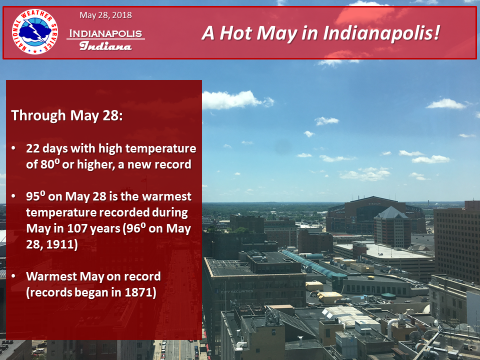
Bring on Alberto! My word we need the rainfall here. The heaviest is staying west of Indy but we should still get a good soaking tonight and tomorrow. We haven't had a drop of rain since May 19. And just 1.11 inches of rain since May 1st, in a month that averages over 5 inches. The grass is already browning up about a month after it got warm enough to for it to finally make a return to green from winter. Plus, Alberto will bring a break to this heat and the record warm May so far!
Bring on Alberto! My word we need the rainfall here. The heaviest is staying west of Indy but we should still get a good soaking tonight and tomorrow. We haven't had a drop of rain since May 19. And just 1.11 inches of rain since May 1st, in a month that averages over 5 inches. The grass is already browning up about a month after it got warm enough to for it to finally make a return to green from winter. Plus, Alberto will bring a break to this heat and the record warm May so far!
So interesting whats happening and the differences... There lack of rain and lots of sun(I think)
Here so many rainy days and lack of clouds
Check out all the fronts happening this week and then what happens end of the weekend into next week...again?
Quote:
Area Forecast Discussion
National Weather Service New York NY
707 AM EDT Tue May 29 2018
.SYNOPSIS...
A backdoor frontal passage this evening will allow high
pressure to build in on Wednesday. A warm front approaches from
the south late Wednesday night, passing north of the region
late Thursday into Friday. A cold front then passes through the
region Friday night. The cold front becomes stationary south of the area Saturday and remains into the beginning of next week.
Forecast on track with just a few minor adjustments to reflect
latest observations. Otherwise, a cold front over Quebec will
reach the cwa this afternoon. It will be shallow, and slowed by opposing sea breeze flow across the area. As a result, the front is not expected to be completely thru the cwa until the eve. This will allow for a better chc for isold shwrs and tstms
to develop. Shear is weak, so multicellular mode is expected
should anything get triggered. The best chc is across CT into
the Lower Hudson Valley and NJ for initiation, with too much cin
at the coasts attm. Storm motion is progged to be sly or swly
blw 10 kt, so shwrs and tstms could drift into the more stable
environs before completely weakening. For now, the fcst has been
kept dry across LI with the Sound expected to allow for
significant weakening. If CAPE verifies higher than the model
progs today, slgt chcs will need to be expanded to the island.
The NBM was used for temps, with coastal influences well
represented by the data. Any pcpn dissipates this even with a
loss of daytime heating and the passage of the front. Some
patchy fog was included with lgt onshore flow developing. In
addition to any fog development, there does seem to be a good
signal for marine stratus to roll in. Cloud cover was weighted
towards the NAM llvl rh fields. The NBM was used for lows.
.SHORT TERM /WEDNESDAY/...
Dry wx with hipres building in. The big question is how cloudy it is. Marine stratus is expected in the mrng, so the fcst burns this off slowly thru about 16z. If the stratus doesn`t develop, it should still be fairly cloudy with bkn-ovc cirrus. The
significant high cloudiness is expected thru the remainder of
the day as subtropical moisture pours into the region. Cloud
cover has been ramped up in the fcst as a result. The NBM was
used for temps.
So we got stalled fronts, marine layer, and subtropical moisture all causing clouds.
Quick update: 3rd morning in a row with clouds again. Crazy how these fronts are stalling. Was hoping we didn't get another crappy May again.
You can definitely see the struggle in the garden.
May 12: Overcast morning and all day. 0 Hours of sun
May 13: Overcast morning and all day. 0 Hours of sun
May 14: Overcast morning. 4 Hours of sun
May 15: Overcast morning. 2 Hours of sun
May 16: Overcast morning and all day. 0 Hours of sun
May 17: Overcast morning and all day. 0 Hours of sun
May 18: Overcast morning. 1 Hours of sun
May 19: Overcast morning. 0 Hours of sun
May 20: Overcast morning. 2 Hours of sun
May 21: Sunny Morning and all day. 12 Hours of sun
May 22: Overcast morning. 0 Hours of sun
May 23: Overcast morning then sun. 7 Hours of sun.
May 24: Sunny morning and all day. 13 hours of sun.
May 25: Sunny morning and all day. 13 hours of sun.
May 26: Sunny morning then cloudy. 5 hours of sun.
May 27: Overcast morning. 0 Hours of sun
May 28: Overcast morning. 0 Hours of sun
May 29: Overcast morning.
59 hours of sun(4.5 days) in last 432 hours (18 days)
I'm so jealous of the Chicago weather. We had a great Saturday, but an absolutely dreadful Sunday/Monday. Today is nice in NYC (so will tomorrow be), but the forecast calls for rain and below normal temps for a week out. We really haven't had a stretch of nice weather.
Another 0% sunshine day for my area. No real rain but inland as we are back to a reverse west windflow. I expect big time drying out soon and could go weeks without any real rain.
Please register to post and access all features of our very popular forum. It is free and quick. Over $68,000 in prizes has already been given out to active posters on our forum. Additional giveaways are planned.
Detailed information about all U.S. cities, counties, and zip codes on our site: City-data.com.

 Please register to participate in our discussions with 2 million other members - it's free and quick! Some forums can only be seen by registered members. After you create your account, you'll be able to customize options and access all our 15,000 new posts/day with fewer ads.


")


