Spring 2016 thread (Northern Hemisphere) (warm, sprinkle, days, degree)
Please register to participate in our discussions with 2 million other members - it's free and quick! Some forums can only be seen by registered members. After you create your account, you'll be able to customize options and access all our 15,000 new posts/day with fewer ads.
Fat lady hasn't sung yet. Well, for New England at least, not me. Don't think I'll see flakes. Close.
8 days into the future and in April which is harder and riskier to call snow.
Quote:
Originally Posted by Cambium
You have a few more chances to hit freezing coming up plus the S word again in the Northeast somewhere. Lets figure the mountains have the better chance at the snow for now.
Quote:
Originally Posted by Cambium
Speaking of snow... Maybe some flakes for me coming? Euro is onto it.
Quote:
Originally Posted by Cambium
from what I been seeing and even going forward.. the Polar Jet Stream doesn't want to give up and there's been some pretty cold air around north of the border.
NWS Gray Maine... Fire to Snow.
EXPECT TEMPERATURES TO WET BULB IN THE DRY AIRMASS AND IN A
CRUEL TURN OF EVENTS ALLOW RAIN TO TURN TO SNOW OVER SOUTHERN AND
CENTRAL NH AS WELL AS PORTIONS OF WESTERN MAINE. SEVERAL MODELS
POINT TO A 2-4" SNOWFALL...WHICH IS NOTABLE ON THE HEELS OF A RED
FLAG DAY. THERE WILL BE A FLUFF FACTOR AND HAVE KEPT AN AVERAGE
OF 3" IN THE GRIDS. OVERNIGHT LOWS WILL RANGE FROM THE 20S
NORTH...WHERE THERE WILL BE LESS CLOUD COVER AND NO
PRECIPITATION... TO THE MID 30S SOUTH UNDER CLOUD COVER.
What tight gradient? I'll take my 59° and be happy with it I guess.
Please register to post and access all features of our very popular forum. It is free and quick. Over $68,000 in prizes has already been given out to active posters on our forum. Additional giveaways are planned.
Detailed information about all U.S. cities, counties, and zip codes on our site: City-data.com.

 Please register to participate in our discussions with 2 million other members - it's free and quick! Some forums can only be seen by registered members. After you create your account, you'll be able to customize options and access all our 15,000 new posts/day with fewer ads.


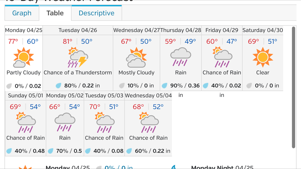


 I'll take my 59° and be happy with it I guess.


