Arctic U.S East In January 2012? (precipitation, storms, season, dewpoint)
Please register to participate in our discussions with 2 million other members - it's free and quick! Some forums can only be seen by registered members. After you create your account, you'll be able to customize options and access all our 15,000 new posts/day with fewer ads.
The weather has been pretty mild up in the Canadian Arctic so far. Because of this, I don't expect there to be a major cold wave entering the lower-48 any time soon. The weather forecast for Yellowknife is showing warmer than normal temps.Yellowknife's forecast seems very toasty compared to Fairbanks in the upcoming weeks. If you are interested in predicting cold waves, just follow the weather forecast for Yellowknife or some cities in the Canadian Arctic.
- I'm not sure if this is the way it works, but my prediction is that the current cold air mass in Interior Alaska will get pushed over to Canada sometimes in the upcoming weeks, and subsequently down to the lower-48. Whenever Fairbanks gets below-average temps, Yellowknife and the lower-48 states are always warmer than the average. Soon enough, the cold air from AK moves to the Canadian side and brings colder than average temps to the lower-48 states.
To get very cold arctic air in the Canadian Arctic you need to have cross-polar flow, or a transfer of cold air from Siberian Russia over the other side of the pole into Canada and Alaska. This is usually caused by a block in the eastern Pacific or ridge which allows the airmass transfer to take place. So far this winter that has not happened at all due to the fact that we have a split flow pattern and persistent lows in the Gulf of Alaska that have kept any true cold air well off to the far north and Alaska. Typically with a positive NAO and AO pattern the arctic regions tend to be colder than average, but I don't think that has been the case either as it seems like every region has recorded temperatures well above average for the past few months.
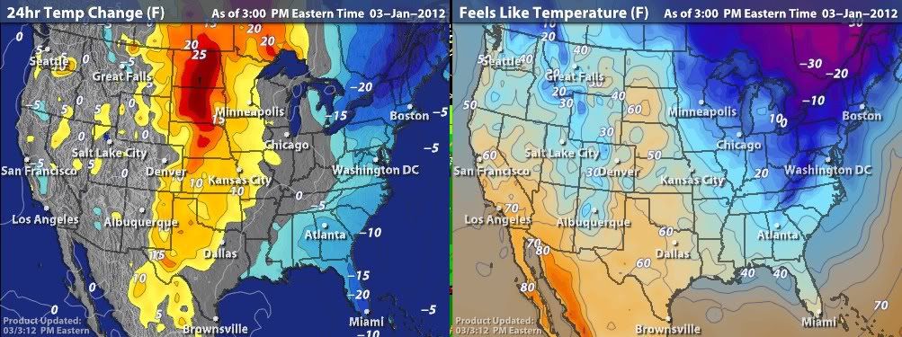
Looks like a major freeze is in store for Florida tonight. Hard Freeze warnings in Tampa, Sarasota, Orlando, Titusville, and points north. Freeze warnings all the way to the southern tip of Florida, excluding the Keys and the Miami area. The NWS in Tampa is expecting a low of 25 there tonight!! Temps into the 30s will be seen in the suburbs of western Miami metro.
Some chilly 2pm temps:
Orlando: 45 F
Daytona Beach: 45 F
Okeechobee: 50 F
Melbourne: 49 F
Vero Beach: 50F
Tampa: 48 F
Tallahassee: 44 F
Pensacola: 46 F
Jacksonville: 41 F
Miami: 54 F
Ft. Myers: 54 F
Naples: 54 F
Key West: 61 F
Ian
Last week they were only predicting a low of 55F in Miami. That was way off.
Currently, it is about 70F in Brownsville. I'd say it is looking more tropical than Miami in this current cold wave.
29*F in Bokeelia, Florida?! That's supposed to be the warmest place on the Gulf side of Florida! Looks like the very southern part of Pinellas peninsula (coastal St. Petersburg) and Naples will have the warmest lows on the Gulf side, predicted lows in the mid 30s*F.
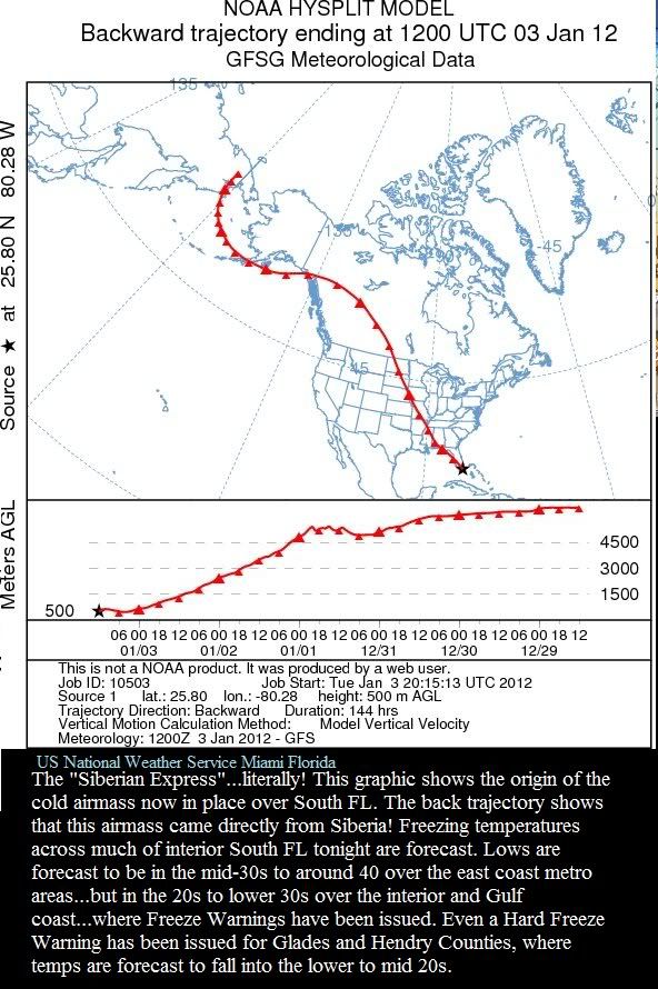
Predicted low of 25F into south-central Florida. Seems even in an otherwise mild winter, the cold can still hit so far south. Very continental coming straight from the Arctic. Accu-Weather forecasted lows for Florida:
Caribou, ME: 5 F
Saranac Lake, NY: -3 F
Boston, MA: 23 F
Albany, NY: 15 F
NYC: 24 F
Philadelphia, PA: 26 F
Washington, DC: 28 F
Virginia Beach: 32 F
Myrtle Beach, SC: 37 F
Atlanta, GA: 34 F
Tallahassee, FL: 45 F
Tampa, FL: 46 F
Orlando, FL: 46 F
Ft. Myers, FL: 53 F
Miami, FL: 52 F
Key West, FL: 57 F
A few highlights:
-Tomorrow's high in Caribou is only forecasted to reach 9 F.
-Saranac Lake, NY's forecasted low for tonight is -13 F.
-Boston, NYC, and Philadelphia may not get out of the 20s. Washington DC's forecasted high is 35 F.
-A low of 48 F is being forecasted tonight for Key West, FL. Miami will be around 40 F, West Palm Beach 35 F. A freeze is expected throughout much of Florida. Homestead, FL is forecasted to drop down to 33 F.
Today's high was 25°F, yesterday's was 47°F, a 22°F drop.
It's 19°F now, not that rare for winter, but has only happened a few times so far this winter. 3°F tonight.
Please register to post and access all features of our very popular forum. It is free and quick. Over $68,000 in prizes has already been given out to active posters on our forum. Additional giveaways are planned.
Detailed information about all U.S. cities, counties, and zip codes on our site: City-data.com.

 Please register to participate in our discussions with 2 million other members - it's free and quick! Some forums can only be seen by registered members. After you create your account, you'll be able to customize options and access all our 15,000 new posts/day with fewer ads.