Please register to participate in our discussions with 2 million other members - it's free and quick! Some forums can only be seen by registered members. After you create your account, you'll be able to customize options and access all our 15,000 new posts/day with fewer ads.
I live approximately 50 miles west of NYC and the average January low is 16 F (1981-2010). Last winter it dropped down to -11 F and it dropped down to -15 F a couple years. Most years drop below zero at least a couple times. Last year's average January low was 12 F.
With regard to skiing, I've skiied in Colorado. Though the air was quite dry for this recent blast, the air out west is generally drier. I found 20 F more comfortable in Colorado than I would in New Jersey. Here it's often breezy and damper while calm conditions often prevail out west. I'm not sure if they make snow out west, but here they do and it can be frigid skiing in 10 F conditions with man-made snow blowing everywhere.
"Florida will have another freeze next week again with Arctic air"
"There is a flip coming mid month that will be talked about for years"
"Models past Day 5 will all look different but will have the general idea trough is coming"
^
We will see. I do think the GFS is really struggling with the pattern flip in the medium and longer range. If you look at the 0Z and 6Z GFS models today they really try to mute the arctic air coming down into the US. A caveat would be that the southern tier continues to warm very quickly so that might be trying to shift the jet stream further north than its typical position.
After these couple days of 10-15 degrees above normal for some, it will dropback to near normal. They all are talking about this cold invasion after mid month.
The Euro models doesnt show it to be severe. But the Ensembles do.
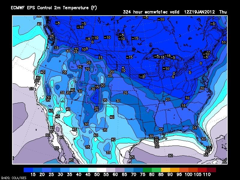
Here's the coldest frame I can find, the rest werent as cold. I think its going to be the deepness of it again, rather than the NorthEast/New England or Upper MidWest making headlines.
This is morning of January 19th. Surface temps without wind chills.
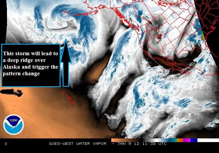
Well... Only 9 days into January... Record high temps after the second arctic blast came through. Now.... Here she is...the pattern changer.
11 more weeks of winter so plenty of time to go. Ridgeing should form over Alaska therefore sending polar vortex south finally. Trough "should" setup in the East and much of U.S for that matter.
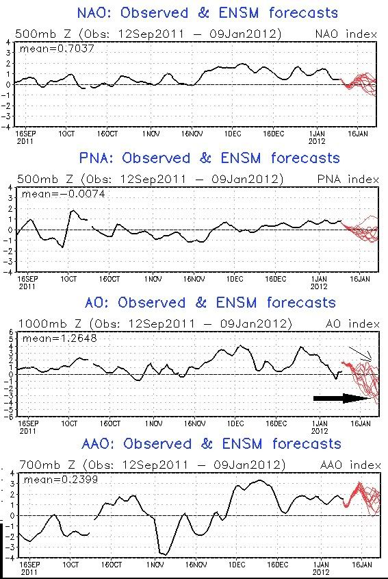
These are some of the teleconnections. All very important especially the NAO and AO.
Take a look at the AO.
Its not just going to neutral or negative...Its going to deeply negative.
In short what this means is winds will lessen (storms move slower across country) and Polar Vortex drops (cold air filters down and stays)
These indices change every few weeks but we have not seen a sustained negative AO like this since last year. The red lines are model prjections...Yes there are a couple that dont take it down that low but a majority do.
"Florida will have another freeze next week again with Arctic air"
"There is a flip coming mid month that will be talked about for years"
"Models past Day 5 will all look different but will have the general idea trough is coming"
I guess it was hype. LOL So what changed? We're still getting the cold but looks like it wont last like they were saying. ...
I guess it was hype. LOL So what changed? We're still getting the cold but looks like it wont last like they were saying. ...
If you look at yearly averages, they don't seem to vary that much. Do you think we are going to get a cool spring/summer to make up for these mild winter temps? If this keeps up, imagine what summer temps will be like. I just think at some point, below normal temps have to kick in for a few months.
If you look at yearly averages, they don't seem to vary that much. Do you think we are going to get a cool spring/summer to make up for these mild winter temps? If this keeps up, imagine what summer temps will be like. I just think at some point, below normal temps have to kick in for a few months.
Well, you're right about the averages, at some point we have to go back to below normal after all this above normal. I'm thinking that will happen in late winter/Early Spring and then BANG right to summer.
New ENSO data suggests that not only is La Nina starting to weaken but that a more neutral orientation of La Nina is going to influence the Spring pattern, remember there is a lag time period to account for when dealing with ENSO.
What I find even more interesting is the rapid weakening of ENSO to a neutral state by March. I know there is some out there suggesting that an El Nino is on the way. Is it possible? Yes, of course. However at this point all data point to a neutral ENSO rather than an El Nino for the Spring pattern at this point.
So what does this data suggest going forward? Well, a neutral ENSO state for late March and April would suggest a quick and warm start to Spring just in time for the start of the up coming baseball season. The disturbances associated with the Sub Tropical Jet stream will be more energetic, however unlike last year where the abnormally cold stratosphere helped to enhance thunderstorms, the severe weather potential for the northern Mid Atlantic is not looking as robust as the past two years.
By the way, this discussion has NOTHING to do with the current evolving winter pattern. I simply felt it was time in the Long Range Discussion to start to put down some preliminary Spring thoughts.
Please register to post and access all features of our very popular forum. It is free and quick. Over $68,000 in prizes has already been given out to active posters on our forum. Additional giveaways are planned.
Detailed information about all U.S. cities, counties, and zip codes on our site: City-data.com.

 Please register to participate in our discussions with 2 million other members - it's free and quick! Some forums can only be seen by registered members. After you create your account, you'll be able to customize options and access all our 15,000 new posts/day with fewer ads.


 ...
...
