Arctic U.S East In January 2012? (locations, cloud, comparison, degrees)
Please register to participate in our discussions with 2 million other members - it's free and quick! Some forums can only be seen by registered members. After you create your account, you'll be able to customize options and access all our 15,000 new posts/day with fewer ads.
Freeze Watch for Florida Alachua, Baker, Bradford
Citrus, Clay, Columbia
Duval, Gilchrist, Hamilton
Hernando, Levy, Marion
Nassa, Putnam, Sumter
Suwannee, Union
THE NATIONAL WEATHER SERVICE IN TAMPA BAY AREA - RUSKIN FL HAS
ISSUED A FREEZE WATCH...WHICH IS IN EFFECT FROM LATE TONIGHT
THROUGH SATURDAY MORNING.
* TEMPERATURE...BELOW FREEZING FOR 2 TO 4 HOURS LATE TONIGHT. LOWS WILL DROP AS LOW AS THE UPPER 20S ACROSS INTERIOR NORTHERN LEVY COUNTY. ELSEWHERE THE LOWS WILL BE IN THE LOW 30S.
* IMPACTS...TEMPERATURES THIS COLD CAN KILL SENSITIVE VEGETATION
THAT IS NOT PROPERLY PROTECTED.
Snowstorm in Upstate NY and Northern New England. Cold, windy weather elsewhere.
Here's some current temperatures:
Marquette, MI: 16 F
Detroit, MI: 29 F
Buffalo, NY: 22 F
Cleveland, OH: 22 F
NYC: 34 F Boston: 52 F
Louisville, KY: 22 F
Philadelphia, PA: 34 F
Washington, DC: 39 F
Virginia Beach: 41 F
Nashville, TN: 28 F
Atlanta, GA: 33 F
Columbia, SC: 40 F
Myrtle Beach, SC: 45 F
Tallahassee, FL: 45 F
Jacksonville, FL: 48 F
Tampa, FL: 56 F
Orlando, FL: 57 F
Miami, FL: 71 F
Key West, FL: 75 F
New Orleans, LA: 44 F
Houston, TX: 47 F
McAllen, TX: 54 F
Tuesday looks to be the only mild day (46 F). The rest are forecasted to be below average. Hopefully it stays this way!
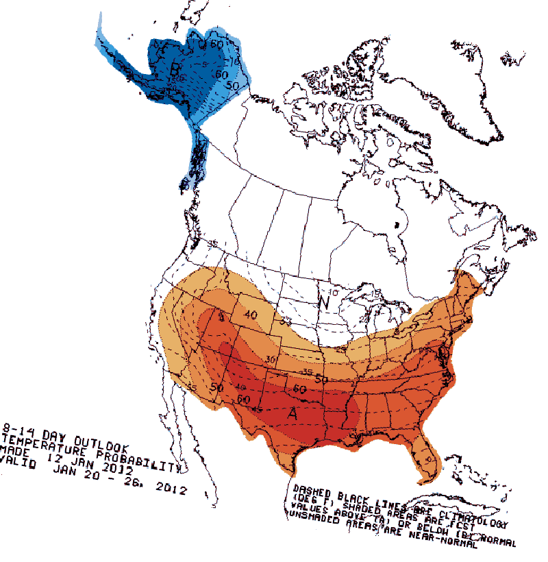
I know cold weather/winter weather fans want it to...but one look at the 8 to 14 day temp outlook and I don't think it will:
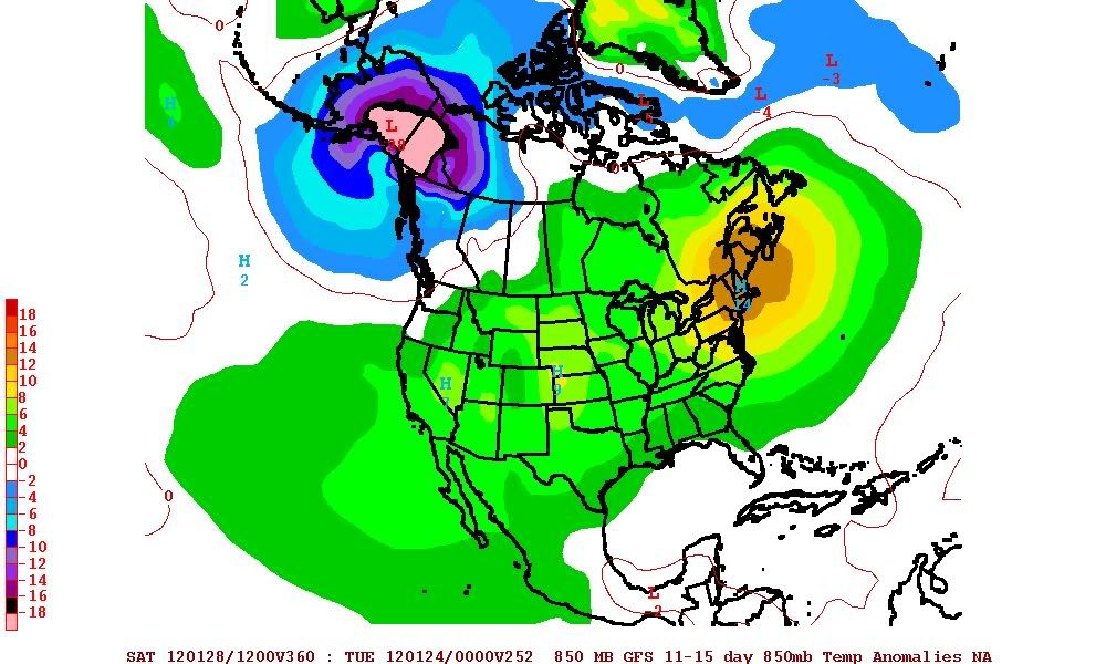
One look at the forecast for temps through the end of the month shows that much of the USA will see above normal temps...with only the Midwest and far West Coast seeing normal temps. The colder than normal temps look to stay in Alaska and the far West Coast of Canada. This is only the "forecast" of course, and things could change, but given the pattern I would think that this cold snap will be history in 48 - 72 hours. In fact, after this cold snap, there looks to be near record warmth for much of the USA around the 24 - 26th of January. Here is the GFS temp anomlies for the 25th - 90% of the USA could ssee warmer than average conditions...only the PNW will see cold weather. Again, this is just a "forecast"...but I would think the weather would have a hard time coming out at the oppsite end of these forecasts. In other words...its a good bet the cold will not hang around long
Yes, I have heard of the possibility of record warmth at the end of the month, but it is still too far out to make a definitive call. I even posted about this month being somewhat similar to January 1950 (reached 68 F here at the end of the month). We'll see what happens.
The pattern actually did change, but it still may not work out in our favor (for winter lovers).
In the meantime, enjoy the winter blast wavehunter.
That would be very interesting. The warmth looks more in the south, though so it might not effect us. For sure, it looks like the cold snap next week is definite while the longer term forecast is more probabilistic.
Cold snap gone in 2-3 days? My forecast shows, except one day, it staying for the whole week, colder than anything so far this winter.
I'll watch the forecast closely to see if the warmth is coming. Wasn't there something about the positive Arctic Ocillation weakening soon?
Good discussion on whats happening. Basically the stratosphere warming isnt favoring the PV to drop this way. So we'll be in this flip flop pattern for at least another 2 weeks.
Cold a few days. Warm 1 or 2 days. Notice the warm days aren't lasting long. The upper levels are definetly changing... So we'll have to see. Dont believe anything past 5 days, especially 2 weeks.
The blast will last till Tuesday but Saturday night, Sunday and Sunday night being the worst of it.
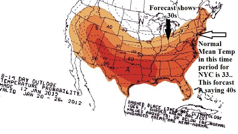
Hopefully this post will help others better understand those CPC maps.
1. Dont ever trust anything more then 7 days out. Things can change 5 days out. Those maps are practically 2 week "predicitions".
2. It's based on a "mean" temperature. Some people see that red and think summer or hot temps... In other words take the average High temps and average low temps and get the middle. So some spots mean temp is in the 20s therefore above would mean low 30s technically. (See first pic)
3. Its based on the entire period so it DOES NOT mean the entire time 8-14 days will be above normal. We can have teens for 5 days and mid 40s for 6 days and it will be considered "above" normal. (See 2nd pic)
I dont know about you but Spring, Summer, and Fall temps aren't in the 30s and 40s. Thats winter to me. Thats directly from CPC. I hope this clears things up for some.
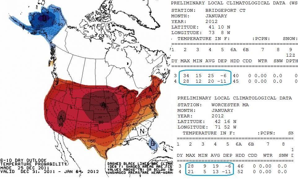
Here's CPC's map from December showing Above normal for Dec.31-Jan4 time period. Do we remember what happened January 3rd and 4th??? Well below. Departures were -6 to -11 below normal!
Well said Cambrium. This has been a pretty unpredictable winter, so who knows what the end of the month will bring. As we get closer, there'll be more certainty. But in the mean time, it looks like it'll remain average to below average for the next few days.
Please register to post and access all features of our very popular forum. It is free and quick. Over $68,000 in prizes has already been given out to active posters on our forum. Additional giveaways are planned.
Detailed information about all U.S. cities, counties, and zip codes on our site: City-data.com.

 Please register to participate in our discussions with 2 million other members - it's free and quick! Some forums can only be seen by registered members. After you create your account, you'll be able to customize options and access all our 15,000 new posts/day with fewer ads.