Arctic U.S East In January 2012? (average, night, storm, cities)
Please register to participate in our discussions with 2 million other members - it's free and quick! Some forums can only be seen by registered members. After you create your account, you'll be able to customize options and access all our 15,000 new posts/day with fewer ads.
That would make you feel better for being in Vancouver Canada.
Sometimes in winter almost every year, Vancouver can be warmer than Dallas, Atlanta, and even Northern Florida.
Also, the all time record lows for Dallas, Atlanta, and parts of Northern Florida such as Tallahassee and Jacksonville are actually lower than Vancouver's all time record low.
Actually Jacksonville's record low is a few degrees higher than Vancouver.
Of course all things considered, I'd much rather have Jacksonville's climate than Vancouver's
It will be interesting to see how far south this current cold snap goes and any other future cold snaps this winter... I find East Coast/Midwest cold snaps fascinating
This one looks cold, but not really severe. The most severe ones will bring below zero Fahrenheit temps to Western MA and upstate NY and single digits to NYC/ Long Island, and this one isn't forecast to do that. I think you need cold outbreaks that severe in the north to get the cold to go really far south.
Perhaps in a more normal winter, where the ground was snow covered and the ground colder, and outbreak like this would have more bite.
Last I checked, Miami is only forecasted to go down to about 55 F at night. Not impressive, even for that area, but still a refreshing change from their usual weather.
12-31-2011, 12:52 AM
Status:
"From 31 to 41 Countries Visited: )"
(set 27 days ago)
4,640 posts, read 13,941,473 times
Reputation: 4052
I found a new populated place that will be even more impressively colder than Montreal and Quebec City.
The Quebec town of Val-d’Or has a forecast high temperature of -11 below zero and a low of -22 below zero/cloudy/and windy with 22mph Northwest winds on January 4th. I assume 22mph sustained winds would give a -25 to -40 wind chill. Val-d’Or is also forecasted to be cloudy every day for the next 10 days in a row and also snow for 9 out of those 10 days to “complement” the extreme cold.
31,000 people live in Val-d’Or. That is a similar population to the amount of people that live in Burlington Vermont. Burlington has a forecast high/low of 13/1 for January 4th.
I agree -Not that severe and if there was snow pack it would feel worse. Maybe if the great lakes area gets a foot+ we'll have something to start with, but its been pretty snowless everywhere still.
COLD ARCTIC AIR MASS BEGINS TO PLUNGE INTO THE AREA LATE SUNDAY NIGHT. TEMPS BELOW NORMAL SUNDAY NIGHT AND MONDAY. THE BRUNT OF THE COLD AIR ARRIVES MONDAY NIGHT WITH A HARD FREEZE POSSIBLE ACROSS THE INLAND AREAS AND A LIGHT FREEZE ALONG THE COAST. WIND CHILLS DIP INTO THE TEENS ACROSS SE GA AND 20 TO 25 ACROSS NE FL. WIND CHILL ADVISORIES APPEAR LIKELY IN NE FL AND ARE POSSIBLE IN SE GA
Let me just give you my take on this pattern, as I find this quite interesting as well:
Back in early November when the cool season started - there were signs that the trough would set up near/or over the West Coast… and the central and eastern USA would have a warm November and December. Of course, most who predicted this were quite right: While November and December were mild in the eastern and central USA, the West Coast and even parts of the desert southwest had a cool month, as many NWS stations in California like Los Angeles had Nov/Dec monthly mean temps 2 to 3 F below normal. Meanwhile NWS stations like Chicago (7 F above normal for December), St. Louis (5.8 F above normal for December), and NYC (5. 4 F above normal for December) had a sunny, dry, and mild first month of meteorological winter.
Then, about two weeks ago (around the 18th or so), the trough seemed to migrate eastward and settle just to the east of the Rockies. While this means there has been some eastward movement of the pattern (and storm track) since the cold season started in November…the whole pattern has really only migrated about 400- 500 miles eastward. Additionally, this has been what’s often called a “fast pattern" – meaning that weather systems and air masses come and go very quickly in the fast upper level flow. So what does this mean to me?
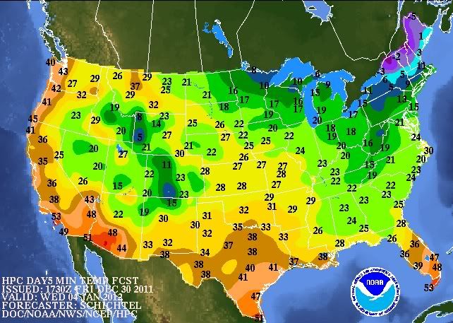
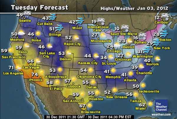
1) While I have no doubt that the coldest air this winter (although I think the models are overdoing it a bit as usual) will hit the central and eastern USA (and even the immediate East Coast to some extent)…it will truly be fleeting in its staying power. The fast flow will allow the cold air to come and go very quickly. Cities like St. Louis, Chicago, Cincinnati, NYC, Boston, Washington, DC…etc will see one or at the most perhaps two days with below normal temps – before a quick rebound to normal (or even slightly above normal temps) return: The heart of the cold front (and coldest temps) will reach the central and eastern USA by Tue, with a northwest flow aloft, then in less than 48 hours, the flow will turn west/southwest again by Thur. Here are the Tue and Thur maps - they show Chicago having highs only in the lower 20's and cities like NYC and Washington at or below freezing on Tue....followed by highs back in the 40's on Thur:
The lack of snow cover mentioned above (NEI) I also think is very important – and I think will play a role in the pattern in January: As most of us know, the coldest air that enters the USA enters the mainland over Montana and North Dakota, then is drawn eastward across the Midwest and East and finally off the upper East Coast. The lack of snow cover in the Midwest means that as these air masses move eastward… they will modify faster than they normally would. So for the further east you are, the less you might feel of these cold air masses (relatively speaking): So for example, I think January mean temps at stations like Des Moines or St. Louis will end closer to normal…while stations in the far east like Washington DC or NYC, will see warmer than normal temps through January.
I know winter fans in the central and eastern USA are hoping for some sustained cold and some snow . However, outside of the Great Lakes and upper New England…I think as long as the trough stays where it is (just to the east of the Rockies), the pattern stays fast, and the NAO stays natural or strongly positive (like it has been in the last few months)…there will be little real change in the central and eastern parts of the mainland (from around 40 latitude southward or so) in terms of seeing below normal temps and snowy pattern. There are some signs that by mid Feb the pattern might change. Keep in mind we can’t expect what happened in the last two winters to happen every winter – they were 50 to 100 year extremes.
Bret explains it well here. He is Canadian, so he knows somthing of cold and snow - lol:.
AccuWeather.com - Brett Anderson | Random Thoughts (http://www.accuweather.com/en/weather-blogs/anderson/random-thoughts/59695 - broken link)
Again, when accuweather fits what YOUR view of the weather is, then it's accurate huh? When accuweather predicts cold conditions, it's "Hype" but when accuweather predicts mild conditions then you use it as a source?
1) While I have no doubt that the coldest air this winter (although I think the models are overdoing it a bit as usual) will hit the central and eastern USA (and even the immediate East Coast to some extent)…it will truly be fleeting in its staying power.
The more I think about it, the more I agree about the hype assessment. It's definitely a cold snap, but at least for the northeast it's not all that extremely cold; not near a typical coldest of the entire winter cold. The cold reaching that far south might be unusual, I'm not that familiar with the US.
Though, the coldest part of the winter is just starting. Usually the most severe cold weather is between mid January to mid February, so it's likely we'll get a bigger arctic blast, even if the winter is a mild one.
Please register to post and access all features of our very popular forum. It is free and quick. Over $68,000 in prizes has already been given out to active posters on our forum. Additional giveaways are planned.
Detailed information about all U.S. cities, counties, and zip codes on our site: City-data.com.

 Please register to participate in our discussions with 2 million other members - it's free and quick! Some forums can only be seen by registered members. After you create your account, you'll be able to customize options and access all our 15,000 new posts/day with fewer ads.


 That is a similar population to the amount of people that live in Burlington Vermont. Burlington has a forecast high/low of 13/1 for January 4th.