Bridge Statistics for Pittsburgh, Pennsylvania (PA)
Condition, Traffic, Stress, Structural Evaluation, Project Costs
- National Bridge Inventory (NBI) Statistics
- 739Number of bridges
- 14,564ft / 4,439mTotal length
- $433,022,000Total costs
- 8,123,148Total average daily traffic
- 545,684Total average daily truck traffic
- National Bridge Inventory (NBI) Registered Bridges for Pittsburgh
- No street view available for this location
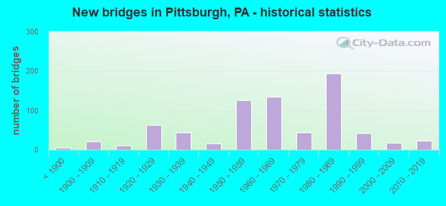
- New bridges - historical statistics
- 5Before 1900
- 211900-1909
- 101910-1919
- 631920-1929
- 431930-1939
- 161940-1949
- 1261950-1959
- 1341960-1969
- 441970-1979
- 1941980-1989
- 421990-1999
- 172000-2009
- 232010-2019
- 12020-2022
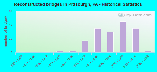
- Reconstructed bridges - Historical Statistics
- 11920-1929
- 01930-1939
- 11940-1949
- 21950-1959
- 21960-1969
- 171970-1979
- 351980-1989
- 301990-1999
- 452000-2009
- 352010-2019
- 22020-2022

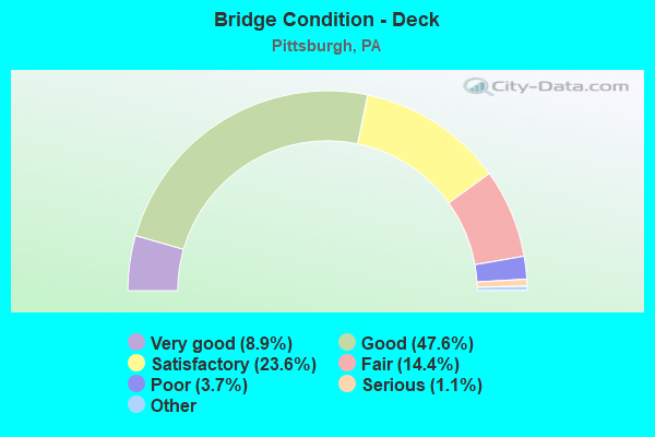
- Bridge Condition - Deck
- 8.9%Very good
- 47.6%Good
- 23.6%Satisfactory
- 14.4%Fair
- 3.7%Poor
- 1.1%Serious
- 0.7%Critical
- 0.4%Imminent failure
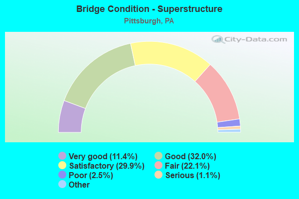
- Bridge Condition - Superstructure
- 11.4%Very good
- 32.0%Good
- 29.9%Satisfactory
- 22.1%Fair
- 2.5%Poor
- 1.1%Serious
- 1.1%Critical
- 0.7%Imminent failure
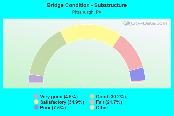
- Bridge Condition - Substructure
- 4.6%Excellent
- 30.2%Very good
- 34.9%Good
- 21.7%Satisfactory
- 7.5%Fair
- 1.1%Poor
- 0.7%Serious
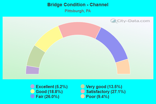
- Bridge Condition - Channel
- 5.2%Excellent
- 13.5%Very good
- 18.8%Good
- 27.1%Satisfactory
- 26.0%Fair
- 9.4%Poor
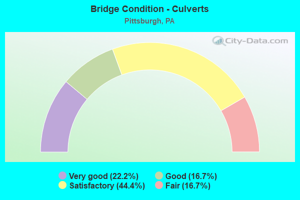
- Bridge Condition - Culverts
- 22.2%Very good
- 16.7%Good
- 44.4%Satisfactory
- 16.7%Fair
Find on map >> Show street view
Structure Number: 4526, Location: Highland Park Bridge (Lat: 40.486239, Lng: -79.913333), Route carried "on" structure: State highway , Year Built: 1940, Year Reconstructed: 1988, Status: Open, Structure Length: 3.54m (11.61ft), Average Daily Traffic: 37,191 (year 2022), Truck Traffic: 7%, Average Future Daily Traffic: 50,540 (year 2032), Design Load: HS 20, Features Intersected: SR 0008, Facility Carried by Structure: HIGHLAND PARK APPR
Minimum Vertical Clearance: 30+ m (98+ ft), Kilometerpoint: 0.000, Lanes on structure: 2, Lanes under structure: 2, Base Highway Network: Yes, Owner: State Highway Agency, Approaching Roadway Width: 13.4m (44.0ft), Skew: 30 degrees, Material/Design: Steel, Design/Construction: Stringer/Multi-beam, Number Of Spans In Main Unit: 3, Length of Maximum Span: 19.5m (64.0ft), Curb or Sidewalk Widths: Left: 0.2m (0.7ft), Right: 0.2m (0.7ft), Curb-To-Curb Width: 11.5m (37.7ft), Out-to-Out Width: 14.3m (46.9ft)
Condition: Deck: Fair, Superstructure: Fair, Substructure: Fair, Operating Rating: 74.4 metric tons, Method Used To Determine Operating Rating: Load Factor (LF), Inventory Rating: 44.5 metric tons, Method Used To Determine Inventory Rating: Load Factor (LF), Structural Evaluation: Somewhat better than minimum adequacy, Deck Geometry: Meets minimum limits, Approach Roadway Alignment: Somewhat better than minimum adequacy, Designated Inspection Frequency: Every 24 months, Critical Feature Inspection Frequency: Every 24 months, Inspection Date: October 2020, Critical Feature Inspection Date: October 2020, Deck Structure Type: Concrete Cast-file-Place, Wearing Surface/Protective System: Wearing Surface: Monolithic Concrete, Deck Protection: Epoxy Coated Reinforcing
Find on map >> Show street view
Structure Number: 45326, Location: Blvd.of Alies to Lib. Br (Lat: 40.429167, Lng: -79.999167), Route carried "on" structure: Spur State highway , Year Built: 1928, Year Reconstructed: 2017, Status: Open, Structure Length: 13.17m (43.21ft), Average Daily Traffic: 2,421 (year 2022), Truck Traffic: 7%, Average Future Daily Traffic: 4,497 (year 2032), Design Load: HS 20, Features Intersected: 1st Ave, 2nd Ave, Local, Facility Carried by Structure: Blvd Al.Ramp
Minimum Vertical Clearance: 30+ m (98+ ft), Kilometerpoint: 0.000, Lanes on structure: 2, Lanes under structure: 6, Base Highway Network: Yes, Owner: State Highway Agency, Approaching Roadway Width: 7.9m (25.9ft), Material/Design: Steel, Design/Construction: Truss - Deck, Number Of Spans In Main Unit: 3, Length of Maximum Span: 73.8m (242.1ft), Curb or Sidewalk Widths: Left: 1.8m (5.9ft), Right: 0.2m (0.7ft), Curb-To-Curb Width: 8.0m (26.2ft), Out-to-Out Width: 8.9m (29.2ft)
Condition: Deck: Good, Superstructure: Fair, Substructure: Good, Operating Rating: 56.2 metric tons, Method Used To Determine Operating Rating: Load Factor (LF), Inventory Rating: 33.6 metric tons, Method Used To Determine Inventory Rating: Load Factor (LF), Structural Evaluation: Somewhat better than minimum adequacy, Deck Geometry: High priority of replacement, Underclear: High priority of corrective action, Approach Roadway Alignment: Meets minimum limits, Designated Inspection Frequency: Every 24 months, Critical Feature Inspection Frequency: Every 24 months, Inspection Date: April 2021, Critical Feature Inspection Date: April 2021, Deck Structure Type: Closed Grating, Wearing Surface/Protective System: Wearing Surface: Latex Concrete
Find on map >> Show street view
Structure Number: 45327, Location: Liberty Br.to Blvd. Alies (Lat: 40.429167, Lng: -79.999167), Route carried "on" structure: Spur State highway , Year Built: 1928, Year Reconstructed: 2017, Status: Open, Structure Length: 13.17m (43.21ft), Average Daily Traffic: 7,060 (year 2021), Truck Traffic: 7%, Average Future Daily Traffic: 3,648 (year 2032), Design Load: HS 20, Features Intersected: 1st Ave, 2nd Ave, Local, Facility Carried by Structure: Liberty Br. ramp
Minimum Vertical Clearance: 30+ m (98+ ft), Kilometerpoint: 0.000, Lanes on structure: 2, Lanes under structure: 10, Base Highway Network: Yes, Owner: State Highway Agency, Approaching Roadway Width: 7.9m (25.9ft), Material/Design: Steel, Design/Construction: Truss - Deck, Number Of Spans In Main Unit: 3, Length of Maximum Span: 73.8m (242.1ft), Curb or Sidewalk Widths: Left: 0.2m (0.7ft), Right: 0.2m (0.7ft), Curb-To-Curb Width: 8.0m (26.2ft), Out-to-Out Width: 8.9m (29.2ft)
Condition: Deck: Good, Superstructure: Fair, Substructure: Good, Operating Rating: 59.0 metric tons, Method Used To Determine Operating Rating: Load Factor (LF), Inventory Rating: 32.7 metric tons, Method Used To Determine Inventory Rating: Load Factor (LF), Structural Evaluation: Somewhat better than minimum adequacy, Deck Geometry: High priority of replacement, Underclear: High priority of corrective action, Approach Roadway Alignment: Equal to present desirable criteria, Designated Inspection Frequency: Every 24 months, Critical Feature Inspection Frequency: Every 24 months, Inspection Date: April 2021, Critical Feature Inspection Date: April 2021, Deck Structure Type: Closed Grating, Wearing Surface/Protective System: Wearing Surface: Latex Concrete
Find on map >> Show street view
Structure Number: 45848, Location: SR 19 OVER S.MAIN ST (Lat: 40.740000, Lng: -80.053889), Route carried "on" structure: US 19, Year Built: 2010, Status: Open, Structure Length: 5.82m (19.09ft), Average Daily Traffic: 29,194 (year 2022), Truck Traffic: 8%, Average Future Daily Traffic: 21,832 (year 2032), Design Load: HS 20, Features Intersected: SR 60 @ SR 19 INTER
Minimum Vertical Clearance: 5.13m (16.83ft), Kilometerpoint: 16.608, Lanes on structure: 2, Lanes under structure: 2, Base Highway Network: Yes, Owner: State Highway Agency, Approaching Roadway Width: 22.6m (74.1ft), Skew: 2 degrees, Material/Design: Steel, Design/Construction: Stringer/Multi-beam, Number Of Spans In Main Unit: 1, Length of Maximum Span: 57.3m (188.0ft), Curb or Sidewalk Widths: Left: 0.3m (1.0ft), Right: 0.3m (1.0ft), Curb-To-Curb Width: 22.6m (74.1ft), Out-to-Out Width: 22.9m (75.1ft)
Condition: Deck: Very good, Superstructure: Very good, Substructure: Very good, Operating Rating: 76.2 metric tons, Method Used To Determine Operating Rating: Load and Resistance Factor (LRFR), Inventory Rating: 59.0 metric tons, Method Used To Determine Inventory Rating: Load and Resistance Factor (LRFR), Structural Evaluation: Equal to present desirable criteria, Deck Geometry: Better than present minimum criteria, Underclear: Meets minimum limits, Approach Roadway Alignment: Equal to present desirable criteria, Designated Inspection Frequency: Every 24 months, Inspection Date: November 2020, Deck Structure Type: Concrete Cast-file-Place, Wearing Surface/Protective System: Wearing Surface: Monolithic Concrete, Deck Protection: Epoxy Coated Reinforcing
Find on map >> Show street view
Structure Number: 45849, Location: WEST END (Lat: 40.442733, Lng: -80.030042), Route carried "on" structure: State highway 51, Year Built: 2010, Status: Open, Structure Length: 5.58m (18.31ft), Average Daily Traffic: 3,519 (year 2022), Truck Traffic: 5%, Average Future Daily Traffic: 8,088 (year 2032), Design Load: HS 20, Features Intersected: SOUTH MAIN STREET
Minimum Vertical Clearance: 30+ m (98+ ft), Kilometerpoint: 32.552, Lanes on structure: 2, Lanes under structure: 2, Base Highway Network: Yes, Owner: State Highway Agency, Approaching Roadway Width: 8.8m (28.9ft), Material/Design: Steel, Design/Construction: Stringer/Multi-beam, Number Of Spans In Main Unit: 1, Length of Maximum Span: 54.9m (180.1ft), Curb or Sidewalk Widths: Left: 0.0m, Right: 0.3m (1.0ft), Curb-To-Curb Width: 8.8m (28.9ft), Out-to-Out Width: 9.8m (32.2ft)
Condition: Deck: Good, Superstructure: Good, Substructure: Good, Operating Rating: 73.5 metric tons, Method Used To Determine Operating Rating: Load and Resistance Factor (LRFR), Inventory Rating: 57.2 metric tons, Method Used To Determine Inventory Rating: Load and Resistance Factor (LRFR), Structural Evaluation: Better than present minimum criteria, Deck Geometry: High priority of corrective action, Underclear: Meets minimum limits, Approach Roadway Alignment: Equal to present desirable criteria, Designated Inspection Frequency: Every 24 months, Inspection Date: December 2019, Deck Structure Type: Concrete Cast-file-Place, Wearing Surface/Protective System: Wearing Surface: Monolithic Concrete, Deck Protection: Epoxy Coated Reinforcing
Find on map >> Show street view
Structure Number: 47751, Location: 301143 OV 10th St. Ext. (Lat: 40.443439, Lng: -80.006253), Route carried "on" structure: Ramp City street , Year Built: 2012, Status: Open, Structure Length: 3.75m (12.30ft), Average Daily Traffic: 6,000 (year 2021), Truck Traffic: 5%, Average Future Daily Traffic: 6,600 (year 2043), Design Load: HL 93, Features Intersected: Tenth St. Bypass, Facility Carried by Structure: Fancourt Street
Minimum Vertical Clearance: 30+ m (98+ ft), Kilometerpoint: 0.000, Lanes on structure: 1, Lanes under structure: 2, Owner: City or Municipal Highway Agency, Approaching Roadway Width: 6.1m (20.0ft), Skew: 7 degrees, Material/Design: Steel, Design/Construction: Stringer/Multi-beam, Number Of Spans In Main Unit: 1, Length of Maximum Span: 23.8m (78.1ft), Curb-To-Curb Width: 11.0m (36.1ft), Out-to-Out Width: 15.2m (49.9ft)
Condition: Deck: Very good, Superstructure: Very good, Substructure: Satisfactory, Operating Rating: 46.3 metric tons, Method Used To Determine Operating Rating: Assigned ratings based on Load and Resistance Factor Design (LRFD) reported by rating factor (RF) using HL93 loadings, Inventory Rating: 35.6 metric tons, Method Used To Determine Inventory Rating: Assigned ratings based on Load and Resistance Factor Design (LRFD) reported by rating factor (RF) using HL93 loadings, Structural Evaluation: Equal to present minimum criteria, Deck Geometry: Superior to present desirable criteria, Approach Roadway Alignment: Equal to present minimum criteria, Designated Inspection Frequency: Every 24 months, Inspection Date: October 2021, Deck Structure Type: Closed Grating, Wearing Surface/Protective System: Wearing Surface: Monolithic Concrete, Deck Protection: Galvanized Reinforcing
Find on map >> Show street view
Structure Number: 48089, Location: 31ST ST/RT 28 RAMP D (Lat: 40.465000, Lng: -79.979444), Route carried "on" structure: Ramp State highway , Year Built: 2013, Status: Open, Structure Length: 10.58m (34.71ft), Average Daily Traffic: 2,778 (year 2022), Truck Traffic: 7%, Average Future Daily Traffic: 3,500 (year 2030), Design Load: HL 93, Features Intersected: ADJ TO NORFOLK SOUTHERN, Facility Carried by Structure: RAMP D
Minimum Vertical Clearance: 30.18m (99.02ft), Kilometerpoint: 0.000, Lanes on structure: 1, Base Highway Network: Yes, Owner: State Highway Agency, Approaching Roadway Width: 5.2m (17.1ft), Material/Design: Prestressed concrete, Design/Construction: Stringer/Multi-beam, Number Of Spans In Main Unit: 4, Length of Maximum Span: 26.5m (86.9ft), Curb or Sidewalk Widths: Left: 0.2m (0.7ft), Right: 0.2m (0.7ft), Curb-To-Curb Width: 4.6m (15.1ft), Out-to-Out Width: 5.6m (18.4ft)
Condition: Deck: Good, Superstructure: Very good, Substructure: Very good, Operating Rating: 71.0 metric tons, Method Used To Determine Operating Rating: Assigned ratings based on Load and Resistance Factor Design (LRFD) reported by rating factor (RF) using HL93 loadings, Inventory Rating: 40.5 metric tons, Method Used To Determine Inventory Rating: Assigned ratings based on Load and Resistance Factor Design (LRFD) reported by rating factor (RF) using HL93 loadings, Structural Evaluation: Equal to present desirable criteria, Deck Geometry: High priority of replacement, Approach Roadway Alignment: Equal to present desirable criteria, Designated Inspection Frequency: Every 48 months, Inspection Date: April 2018, Deck Structure Type: Concrete Cast-file-Place, Wearing Surface/Protective System: Wearing Surface: Monolithic Concrete, Deck Protection: Epoxy Coated Reinforcing
Find on map >> Show street view
Structure Number: 4809, Location: @ INTER W/ 31ST BRIDGE (Lat: 40.464417, Lng: -79.979983), Route carried "on" structure: Ramp State highway , Year Built: 2013, Status: Open, Structure Length: 7.92m (25.98ft), Average Daily Traffic: 2,669 (year 2022), Truck Traffic: 7%, Average Future Daily Traffic: 3,100 (year 2025), Design Load: HL 93, Features Intersected: EMBANKMENT, Facility Carried by Structure: RAMP E
Minimum Vertical Clearance: 30+ m (98+ ft), Kilometerpoint: 0.000, Lanes on structure: 1, Base Highway Network: Yes, Owner: State Highway Agency, Approaching Roadway Width: 5.2m (17.1ft), Material/Design: Prestressed concrete, Design/Construction: Stringer/Multi-beam, Number Of Spans In Main Unit: 3, Length of Maximum Span: 26.5m (86.9ft), Curb or Sidewalk Widths: Left: 0.2m (0.7ft), Right: 0.2m (0.7ft), Curb-To-Curb Width: 4.6m (15.1ft), Out-to-Out Width: 5.6m (18.4ft)
Condition: Deck: Good, Superstructure: Very good, Substructure: Very good, Operating Rating: 71.3 metric tons, Method Used To Determine Operating Rating: Assigned ratings based on Load and Resistance Factor Design (LRFD) reported by rating factor (RF) using HL93 loadings, Inventory Rating: 38.9 metric tons, Method Used To Determine Inventory Rating: Assigned ratings based on Load and Resistance Factor Design (LRFD) reported by rating factor (RF) using HL93 loadings, Structural Evaluation: Equal to present desirable criteria, Deck Geometry: High priority of replacement, Approach Roadway Alignment: Better than present minimum criteria, Designated Inspection Frequency: Every 48 months, Inspection Date: April 2018, Deck Structure Type: Concrete Cast-file-Place, Wearing Surface/Protective System: Wearing Surface: Monolithic Concrete, Deck Protection: Epoxy Coated Reinforcing
Find on map >> Show street view
Structure Number: 48206, Location: 301100 OV RR&PAT BSWY9804 (Lat: 40.459114, Lng: -79.925144), Route carried "on" structure: City street , Year Built: 2013, Status: Open, Structure Length: 3.57m (11.71ft), Average Daily Traffic: 8,242 (year 2012), Truck Traffic: 13%, Average Future Daily Traffic: 11,101 (year 2032), Design Load: HL 93, Features Intersected: ELLSWORTH, E BUSWAY, NSR, Facility Carried by Structure: SOUTH HIGHLAND AVE
Minimum Vertical Clearance: 30+ m (98+ ft), Kilometerpoint: 0.000, Lanes on structure: 2, Lanes under structure: 2, Owner: City or Municipal Highway Agency, Approaching Roadway Width: 11.0m (36.1ft), Skew: 2 degrees, Material/Design: Steel, Design/Construction: Stringer/Multi-beam, Number Of Spans In Main Unit: 2, Length of Maximum Span: 22.6m (74.1ft), Curb or Sidewalk Widths: Left: 3.7m (12.1ft), Right: 3.7m (12.1ft), Curb-To-Curb Width: 11.0m (36.1ft), Out-to-Out Width: 19.0m (62.3ft)
Condition: Deck: Very good, Superstructure: Very good, Substructure: Good, Operating Rating: 52.2 metric tons, Method Used To Determine Operating Rating: Assigned ratings based on Load and Resistance Factor Design (LRFD) reported by rating factor (RF) using HL93 loadings, Inventory Rating: 39.9 metric tons, Method Used To Determine Inventory Rating: Assigned ratings based on Load and Resistance Factor Design (LRFD) reported by rating factor (RF) using HL93 loadings, Structural Evaluation: Better than present minimum criteria, Deck Geometry: Meets minimum limits, Approach Roadway Alignment: Somewhat better than minimum adequacy, Designated Inspection Frequency: Every 24 months, Inspection Date: November 2019, Deck Structure Type: Concrete Cast-file-Place, Wearing Surface/Protective System: Wearing Surface: Monolithic Concrete, Deck Protection: Epoxy Coated Reinforcing
Find on map >> Show street view
Structure Number: 48722, Location: 51/88 INTERCHANGE JUGHAND (Lat: 40.381619, Lng: -79.994844), Route carried "on" structure: Ramp State highway , Year Built: 2014, Status: Open, Structure Length: 1.40m (4.59ft), Average Daily Traffic: 3,845 (year 2022), Truck Traffic: 10%, Average Future Daily Traffic: 400 (year 2032), Design Load: HL 93, Features Intersected: WEYMAN RUN, Facility Carried by Structure: JUGHANDLE
Minimum Vertical Clearance: 30+ m (98+ ft), Kilometerpoint: 0.000, Lanes on structure: 2, Owner: State Highway Agency, Approaching Roadway Width: 7.3m (24.0ft), Skew: 3 degrees, Material/Design: Steel, Design/Construction: Stringer/Multi-beam, Number Of Spans In Main Unit: 1, Length of Maximum Span: 13.1m (43.0ft), Curb or Sidewalk Widths: Left: 1.5m (4.9ft), Right: 0.2m (0.7ft), Curb-To-Curb Width: 7.3m (24.0ft), Out-to-Out Width: 9.9m (32.5ft)
Condition: Deck: Very good, Superstructure: Very good, Substructure: Very good, Channel: Very good, Operating Rating: 64.8 metric tons, Method Used To Determine Operating Rating: Assigned ratings based on Load and Resistance Factor Design (LRFD) reported by rating factor (RF) using HL93 loadings, Inventory Rating: 49.9 metric tons, Method Used To Determine Inventory Rating: Assigned ratings based on Load and Resistance Factor Design (LRFD) reported by rating factor (RF) using HL93 loadings, Structural Evaluation: Equal to present desirable criteria, Deck Geometry: High priority of replacement, Waterway Adequacy: Meets minimum limits, Approach Roadway Alignment: Equal to present desirable criteria, Designated Inspection Frequency: Every 24 months, Inspection Date: December 2019, Deck Structure Type: Concrete Cast-file-Place, Wearing Surface/Protective System: Wearing Surface: Monolithic Concrete, Deck Protection: Epoxy Coated Reinforcing
Find on map >> Show street view
Structure Number: 48912, Location: AT PGH ZOO (Lat: 40.487775, Lng: -79.919536), Route carried "on" structure: State highway 8, Year Built: 2014, Status: Open, Structure Length: 6.68m (21.92ft), Average Daily Traffic: 10,744 (year 2020), Truck Traffic: 7%, Average Future Daily Traffic: 28,894 (year 2032), Design Load: HL 93, Features Intersected: FILL, PED TRAIL, Facility Carried by Structure: BUTLER ST
Minimum Vertical Clearance: 30+ m (98+ ft), Kilometerpoint: 8.814, Lanes on structure: 2, Base Highway Network: Yes, Owner: State Highway Agency, Approaching Roadway Width: 14.6m (47.9ft), Material/Design: Steel, Design/Construction: Stringer/Multi-beam, Number Of Spans In Main Unit: 1, Length of Maximum Span: 65.5m (214.9ft), Curb or Sidewalk Widths: Left: 3.4m (11.2ft), Right: 3.4m (11.2ft), Curb-To-Curb Width: 14.5m (47.6ft), Out-to-Out Width: 23.6m (77.4ft)
Condition: Deck: Very good, Superstructure: Very good, Substructure: Very good, Operating Rating: 50.2 metric tons, Method Used To Determine Operating Rating: Assigned ratings based on Load and Resistance Factor Design (LRFD) reported by rating factor (RF) using HL93 loadings, Inventory Rating: 38.9 metric tons, Method Used To Determine Inventory Rating: Assigned ratings based on Load and Resistance Factor Design (LRFD) reported by rating factor (RF) using HL93 loadings, Structural Evaluation: Equal to present desirable criteria, Deck Geometry: Superior to present desirable criteria, Approach Roadway Alignment: Equal to present desirable criteria, Designated Inspection Frequency: Every 24 months, Inspection Date: October 2019, Deck Structure Type: Concrete Cast-file-Place, Wearing Surface/Protective System: Wearing Surface: Monolithic Concrete, Deck Protection: Epoxy Coated Reinforcing
Find on map >> Show street view
Structure Number: 49134, Location: Duncan Way & Bell Ave (Lat: 40.415283, Lng: -80.077408), Route carried "on" structure: City street , Year Built: 1995, Status: Open, Structure Length: 1.10m (3.61ft), Average Daily Traffic: 200 (year 2015), Truck Traffic: 4%, Average Future Daily Traffic: 400 (year 2035), Design Load: H 20, Features Intersected: Unnamed Tributary, Facility Carried by Structure: Bell Ave
Minimum Vertical Clearance: 30+ m (98+ ft), Kilometerpoint: 0.000, Lanes on structure: 2, Owner: Town or Township Highway Agency, Approaching Roadway Width: 7.3m (24.0ft), Skew: 2 degrees, Material/Design: Steel, Design/Construction: Stringer/Multi-beam, Number Of Spans In Main Unit: 1, Length of Maximum Span: 11.0m (36.1ft), Curb or Sidewalk Widths: Left: 0.0m, Right: 1.5m (4.9ft), Curb-To-Curb Width: 7.3m (24.0ft), Out-to-Out Width: 7.3m (24.0ft)
Condition: Deck: Satisfactory, Superstructure: Good, Substructure: Good, Channel: Satisfactory, Operating Rating: 70.8 metric tons, Method Used To Determine Operating Rating: Load Factor (LF), Inventory Rating: 42.6 metric tons, Method Used To Determine Inventory Rating: Load Factor (LF), Structural Evaluation: Better than present minimum criteria, Deck Geometry: Somewhat better than minimum adequacy, Waterway Adequacy: Better than present minimum criteria, Approach Roadway Alignment: Equal to present desirable criteria, Designated Inspection Frequency: Every 24 months, Inspection Date: May 2021, Deck Structure Type: Concrete Cast-file-Place, Wearing Surface/Protective System: Wearing Surface: Monolithic Concrete
Find on map >> Show street view
Structure Number: 52398, Location: NEAR GLENWOOD INTERCHANGE (Lat: 40.389706, Lng: -79.957053), Route carried "on" structure: State highway , Year Built: 2015, Status: Open, Structure Length: 0.85m (2.79ft), Average Daily Traffic: 5,983 (year 2021), Truck Traffic: 3%, Average Future Daily Traffic: 7,063 (year 2032), Design Load: HL 93, Features Intersected: GLASS RUN, Facility Carried by Structure: GLASS RUN ROAD
Minimum Vertical Clearance: 30.18m (99.02ft), Kilometerpoint: 2.208, Lanes on structure: 2, Owner: State Highway Agency, Approaching Roadway Width: 9.1m (29.9ft), Skew: 6 degrees, Material/Design: Concrete, Design/Construction: Culvert, Number Of Spans In Main Unit: 1, Length of Maximum Span: 8.5m (27.9ft), Curb-To-Curb Width: 9.1m (29.9ft), Out-to-Out Width: 9.1m (29.9ft)
Condition: Channel: Good, Culverts: Very good, Operating Rating: 49.9 metric tons, Method Used To Determine Operating Rating: Assigned ratings based on Load and Resistance Factor Design (LRFD) reported in metric tons, Inventory Rating: 39.0 metric tons, Method Used To Determine Inventory Rating: Assigned ratings based on Load and Resistance Factor Design (LRFD) reported in metric tons, Structural Evaluation: Equal to present desirable criteria, Deck Geometry: High priority of corrective action, Waterway Adequacy: Equal to present minimum criteria, Approach Roadway Alignment: Equal to present desirable criteria, Designated Inspection Frequency: Every 24 months, Inspection Date: June 2020
Find on map >> Show street view
Structure Number: 5244, Location: 250' SOUTHEAST OF SR 0088 (Lat: 40.381408, Lng: -79.995458), Route carried "on" structure: State highway 51, Year Built: 2015, Status: Open, Structure Length: 1.22m (4.00ft), Average Daily Traffic: 11,493 (year 2022), Truck Traffic: 6%, Average Future Daily Traffic: 46,500 (year 2033), Design Load: HL 93, Features Intersected: WEYMAN RUN, Facility Carried by Structure: SAW MILL RUN BLVD
Minimum Vertical Clearance: 30+ m (98+ ft), Kilometerpoint: 25.701, Lanes on structure: 4, Base Highway Network: Yes, Owner: State Highway Agency, Approaching Roadway Width: 13.1m (43.0ft), Skew: 4 degrees, Material/Design: Steel, Design/Construction: Stringer/Multi-beam, Number Of Spans In Main Unit: 1, Length of Maximum Span: 11.3m (37.1ft), Curb or Sidewalk Widths: Left: 1.9m (6.2ft), Right: 0.2m (0.7ft), Curb-To-Curb Width: 13.1m (43.0ft), Out-to-Out Width: 16.2m (53.1ft)
Condition: Deck: Very good, Superstructure: Very good, Substructure: Very good, Channel: Good, Operating Rating: 56.7 metric tons, Method Used To Determine Operating Rating: Assigned ratings based on Load and Resistance Factor Design (LRFD) reported by rating factor (RF) using HL93 loadings, Inventory Rating: 43.4 metric tons, Method Used To Determine Inventory Rating: Assigned ratings based on Load and Resistance Factor Design (LRFD) reported by rating factor (RF) using HL93 loadings, Structural Evaluation: Equal to present desirable criteria, Deck Geometry: High priority of replacement, Waterway Adequacy: Somewhat better than minimum adequacy, Approach Roadway Alignment: Equal to present desirable criteria, Designated Inspection Frequency: Every 24 months, Inspection Date: December 2019, Deck Structure Type: Concrete Cast-file-Place, Wearing Surface/Protective System: Wearing Surface: Monolithic Concrete, Deck Protection: Epoxy Coated Reinforcing
Find on map >> Show street view
Structure Number: 52548, Location: SR 51 and SR 88 Intersect (Lat: 40.382131, Lng: -79.996181), Route carried "on" structure: State highway 88, Year Built: 2015, Status: Open, Structure Length: 0.98m (3.22ft), Average Daily Traffic: 17,445 (year 2020), Truck Traffic: 1%, Average Future Daily Traffic: 19,497 (year 2032), Design Load: HL 93, Features Intersected: Saw Mill Run, Facility Carried by Structure: Library Rd.
Minimum Vertical Clearance: 30+ m (98+ ft), Kilometerpoint: 12.909, Lanes on structure: 6, Base Highway Network: Yes, Owner: State Highway Agency, Approaching Roadway Width: 18.3m (60.0ft), Skew: 9 degrees, Material/Design: Concrete, Design/Construction: Culvert, Number Of Spans In Main Unit: 1, Length of Maximum Span: 9.8m (32.2ft)
Condition: Channel: Very good, Culverts: Very good, Operating Rating: 71.3 metric tons, Method Used To Determine Operating Rating: Assigned ratings based on Load and Resistance Factor Design (LRFD) reported by rating factor (RF) using HL93 loadings, Inventory Rating: 51.8 metric tons, Method Used To Determine Inventory Rating: Assigned ratings based on Load and Resistance Factor Design (LRFD) reported by rating factor (RF) using HL93 loadings, Structural Evaluation: Equal to present desirable criteria, Waterway Adequacy: Equal to present minimum criteria, Approach Roadway Alignment: Equal to present desirable criteria, Designated Inspection Frequency: Every 48 months, Inspection Date: October 2020
Find on map >> Show street view
Structure Number: 5255, Location: SR51 and 88 Intersection (Lat: 40.382169, Lng: -79.996081), Route carried "on" structure: State highway 88, Year Built: 2015, Status: Open, Structure Length: 0.73m (2.40ft), Average Daily Traffic: 17,445 (year 2020), Truck Traffic: 1%, Average Future Daily Traffic: 19,497 (year 2032), Design Load: HL 93, Features Intersected: Weyman Run, Facility Carried by Structure: Library Rd.
Minimum Vertical Clearance: 30+ m (98+ ft), Kilometerpoint: 12.909, Lanes on structure: 6, Base Highway Network: Yes, Owner: State Highway Agency, Approaching Roadway Width: 18.3m (60.0ft), Skew: 9 degrees, Material/Design: Concrete, Design/Construction: Culvert, Number Of Spans In Main Unit: 1, Length of Maximum Span: 7.3m (24.0ft)
Condition: Channel: Very good, Culverts: Very good, Operating Rating: 58.3 metric tons, Method Used To Determine Operating Rating: Assigned ratings based on Load and Resistance Factor Design (LRFD) reported by rating factor (RF) using HL93 loadings, Inventory Rating: 45.4 metric tons, Method Used To Determine Inventory Rating: Assigned ratings based on Load and Resistance Factor Design (LRFD) reported by rating factor (RF) using HL93 loadings, Structural Evaluation: Equal to present desirable criteria, Waterway Adequacy: Equal to present minimum criteria, Approach Roadway Alignment: Equal to present desirable criteria, Designated Inspection Frequency: Every 48 months, Inspection Date: October 2020
Find on map >> Show street view
Structure Number: 52726, Location: 120' south of Provost Rd (Lat: 40.379228, Lng: -79.993603), Route carried "on" structure: State highway 51, Year Built: 2015, Status: Open, Structure Length: 1.28m (4.20ft), Average Daily Traffic: 24,342 (year 2022), Truck Traffic: 5%, Average Future Daily Traffic: 32,329 (year 2032), Design Load: HL 93, Features Intersected: Weyman Run, Facility Carried by Structure: Saw Mill Run Blvd
Minimum Vertical Clearance: 30+ m (98+ ft), Kilometerpoint: 25.701, Lanes on structure: 4, Base Highway Network: Yes, Owner: State Highway Agency, Approaching Roadway Width: 14.3m (46.9ft), Skew: 3 degrees, Material/Design: Steel, Design/Construction: Stringer/Multi-beam, Number Of Spans In Main Unit: 1, Length of Maximum Span: 11.9m (39.0ft), Curb or Sidewalk Widths: Left: 1.7m (5.6ft), Right: 0.2m (0.7ft), Curb-To-Curb Width: 14.3m (46.9ft), Out-to-Out Width: 17.7m (58.1ft)
Condition: Deck: Very good, Superstructure: Very good, Substructure: Very good, Channel: Good, Operating Rating: 72.3 metric tons, Method Used To Determine Operating Rating: Assigned ratings based on Load and Resistance Factor Design (LRFD) reported by rating factor (RF) using HL93 loadings, Inventory Rating: 55.7 metric tons, Method Used To Determine Inventory Rating: Assigned ratings based on Load and Resistance Factor Design (LRFD) reported by rating factor (RF) using HL93 loadings, Structural Evaluation: Equal to present desirable criteria, Deck Geometry: High priority of replacement, Waterway Adequacy: Equal to present minimum criteria, Approach Roadway Alignment: Equal to present desirable criteria, Designated Inspection Frequency: Every 24 months, Inspection Date: December 2019, Deck Structure Type: Concrete Cast-file-Place, Wearing Surface/Protective System: Wearing Surface: Monolithic Concrete, Deck Protection: Epoxy Coated Reinforcing
Find on map >> Show street view
Structure Number: 53592, Location: NEAR SR 3100 (Lat: 40.389639, Lng: -79.940919), Route carried "on" structure: State highway , Year Built: 2017, Status: Open, Structure Length: 0.76m (2.49ft), Average Daily Traffic: 5,983 (year 2021), Truck Traffic: 3%, Average Future Daily Traffic: 5,844 (year 2039), Design Load: HL 93, Features Intersected: GLASS RUN, Facility Carried by Structure: GLASS RUN RD
Minimum Vertical Clearance: 30+ m (98+ ft), Kilometerpoint: 3.421, Lanes on structure: 2, Owner: State Highway Agency, Maintenance Responsibility: Private, Approaching Roadway Width: 8.2m (26.9ft), Skew: 5 degrees, Material/Design: Concrete, Design/Construction: Culvert, Number Of Spans In Main Unit: 1, Length of Maximum Span: 6.4m (21.0ft), Curb-To-Curb Width: 9.1m (29.9ft), Out-to-Out Width: 14.1m (46.3ft)
Condition: Channel: Good, Culverts: Very good, Operating Rating: 61.2 metric tons, Method Used To Determine Operating Rating: Assigned ratings based on Load and Resistance Factor Design (LRFD) reported by rating factor (RF) using HL93 loadings, Inventory Rating: 38.6 metric tons, Method Used To Determine Inventory Rating: Assigned ratings based on Load and Resistance Factor Design (LRFD) reported by rating factor (RF) using HL93 loadings, Structural Evaluation: Equal to present desirable criteria, Deck Geometry: High priority of corrective action, Waterway Adequacy: Superior to present desirable criteria, Approach Roadway Alignment: Equal to present desirable criteria, Designated Inspection Frequency: Every 24 months, Inspection Date: October 2021, Wearing Surface/Protective System: Wearing Surface: Bituminous, Membrane: Preformed Fabric
Find on map >> Show street view
Structure Number: 54496, Location: Greenfield Av ovr I-376 (Lat: 40.428575, Lng: -79.937878), Route carried "on" structure: City street , Year Built: 2017, Status: Open, Structure Length: 14.26m (46.78ft), Average Daily Traffic: 225 (year 2021), Truck Traffic: 10%, Average Future Daily Traffic: 270 (year 2043), Design Load: HL 93, Features Intersected: I-376 Parkway East, Facility Carried by Structure: Greenfield Ave
Minimum Vertical Clearance: 30+ m (98+ ft), Kilometerpoint: 0.000, Lanes on structure: 3, Lanes under structure: 6, Toll: Toll bridge, Owner: City or Municipal Highway Agency, Approaching Roadway Width: 12.5m (41.0ft), Material/Design: Steel continuous, Design/Construction: Arch - Deck, Number Of Spans In Main Unit: 1, Number Of Approach Spans: 2, Length of Maximum Span: 99.4m (326.1ft), Curb or Sidewalk Widths: Left: 3.0m (9.8ft), Right: 0.2m (0.7ft), Curb-To-Curb Width: 12.5m (41.0ft), Out-to-Out Width: 16.4m (53.8ft)
Condition: Deck: Very good, Superstructure: Very good, Substructure: Excellent, Operating Rating: 48.0 metric tons, Method Used To Determine Operating Rating: Assigned ratings based on Load and Resistance Factor Design (LRFD) reported by rating factor (RF) using HL93 loadings, Inventory Rating: 36.9 metric tons, Method Used To Determine Inventory Rating: Assigned ratings based on Load and Resistance Factor Design (LRFD) reported by rating factor (RF) using HL93 loadings, Structural Evaluation: Equal to present desirable criteria, Deck Geometry: Meets minimum limits, Approach Roadway Alignment: Equal to present minimum criteria, Designated Inspection Frequency: Every 24 months, Inspection Date: October 2021, Deck Structure Type: Concrete Cast-file-Place, Wearing Surface/Protective System: Wearing Surface: Latex Concrete, Deck Protection: Epoxy Coated Reinforcing
Find on map >> Show street view
Structure Number: 54694, Location: Term. of Old Brown's Hil (Lat: 40.415967, Lng: -79.915769), Route carried "on" structure: City street , Year Built: 2020, Status: Open, Structure Length: 3.96m (12.99ft), Average Daily Traffic: 150 (year 2020), Truck Traffic: 5%, Average Future Daily Traffic: 150 (year 2040), Design Load: HL 93, Features Intersected: Nine Mile Run, Facility Carried by Structure: MCFARREN ST.
Minimum Vertical Clearance: 30+ m (98+ ft), Kilometerpoint: 0.000, Lanes on structure: 2, Owner: City or Municipal Highway Agency, Approaching Roadway Width: 6.1m (20.0ft), Skew: 3 degrees, Material/Design: Steel, Design/Construction: Stringer/Multi-beam, Number Of Spans In Main Unit: 1, Length of Maximum Span: 39.0m (128.0ft), Curb or Sidewalk Widths: Left: 1.7m (5.6ft), Right: 0.2m (0.7ft), Curb-To-Curb Width: 6.1m (20.0ft), Out-to-Out Width: 8.7m (28.5ft)
Condition: Deck: Very good, Superstructure: Very good, Substructure: Very good, Channel: Very good, Operating Rating: 51.2 metric tons, Method Used To Determine Operating Rating: Assigned ratings based on Load and Resistance Factor Design (LRFD) reported by rating factor (RF) using HL93 loadings, Inventory Rating: 39.5 metric tons, Method Used To Determine Inventory Rating: Assigned ratings based on Load and Resistance Factor Design (LRFD) reported by rating factor (RF) using HL93 loadings, Structural Evaluation: Equal to present desirable criteria, Deck Geometry: Meets minimum limits, Waterway Adequacy: Equal to present desirable criteria, Approach Roadway Alignment: Equal to present desirable criteria, Designated Inspection Frequency: Every 24 months, Inspection Date: September 2020, Deck Structure Type: Concrete Cast-file-Place, Wearing Surface/Protective System: Wearing Surface: Monolithic Concrete, Deck Protection: Epoxy Coated Reinforcing
Find on map >> Show street view
Structure Number: 54732, Location: 1/4 MI NW OF I-376 (Lat: 40.433333, Lng: -80.028889), Route carried "on" structure: State highway , Year Built: 2019, Status: Open, Structure Length: 4.27m (14.01ft), Average Daily Traffic: 4,662 (year 2022), Truck Traffic: 5%, Average Future Daily Traffic: 5,000 (year 2038), Design Load: HL 93, Features Intersected: SR 19, Facility Carried by Structure: SHALER STREET
Minimum Vertical Clearance: 30+ m (98+ ft), Kilometerpoint: 0.000, Lanes on structure: 2, Lanes under structure: 5, Owner: State Highway Agency, Approaching Roadway Width: 6.7m (22.0ft), Material/Design: Steel continuous, Design/Construction: Stringer/Multi-beam, Number Of Spans In Main Unit: 2, Length of Maximum Span: 21.3m (69.9ft), Curb or Sidewalk Widths: Left: 0.2m (0.7ft), Right: 1.7m (5.6ft), Curb-To-Curb Width: 7.9m (25.9ft), Out-to-Out Width: 10.5m (34.4ft)
Condition: Deck: Very good, Superstructure: Very good, Substructure: Very good, Operating Rating: 53.8 metric tons, Method Used To Determine Operating Rating: Assigned ratings based on Load and Resistance Factor Design (LRFD) reported by rating factor (RF) using HL93 loadings, Inventory Rating: 41.5 metric tons, Method Used To Determine Inventory Rating: Assigned ratings based on Load and Resistance Factor Design (LRFD) reported by rating factor (RF) using HL93 loadings, Structural Evaluation: Equal to present desirable criteria, Deck Geometry: High priority of corrective action, Underclear: Equal to present minimum criteria, Approach Roadway Alignment: Better than present minimum criteria, Designated Inspection Frequency: Every 24 months, Inspection Date: May 2021, Deck Structure Type: Concrete Cast-file-Place, Wearing Surface/Protective System: Wearing Surface: Monolithic Concrete, Deck Protection: Epoxy Coated Reinforcing
Find on map >> Show street view
Structure Number: 68228, Location: Fort Pitt Bridge (Lat: 40.439306, Lng: -80.010278), Route carried "on" structure: Interstate 376, Year Built: 1953, Year Reconstructed: 2003, Status: Open, Structure Length: 59.22m (194.29ft), Average Daily Traffic: 53,409 (year 2021), Truck Traffic: 6%, Average Future Daily Traffic: 45,944 (year 2032), Design Load: HS 20, Features Intersected: MON RIVER & WARF, 376 WB
Minimum Vertical Clearance: 30+ m (98+ ft), Kilometerpoint: 32.996, Lanes on structure: 2, Lanes under structure: 2, Base Highway Network: Yes, Owner: State Highway Agency, Approaching Roadway Width: 9.4m (30.8ft), Navigation Control: Yes ( Vertical Clearance: 46.9m (153.9ft), Horizontal Clearance: 750.1m (2,461.0ft)), Material/Design: Prestressed concrete continuous, Design/Construction: Stringer/Multi-beam, Number Of Spans In Main Unit: 36, Length of Maximum Span: 16.5m (54.1ft), Curb-To-Curb Width: 9.4m (30.8ft), Out-to-Out Width: 10.5m (34.4ft)
Condition: Deck: Good, Superstructure: Satisfactory, Substructure: Satisfactory, Channel: Good, Operating Rating: 53.5 metric tons, Method Used To Determine Operating Rating: Load and Resistance Factor (LRFR), Inventory Rating: 40.8 metric tons, Method Used To Determine Inventory Rating: Load and Resistance Factor (LRFR), Structural Evaluation: Equal to present minimum criteria, Deck Geometry: Meets minimum limits, Underclear: High priority of corrective action, Waterway Adequacy: Superior to present desirable criteria, Approach Roadway Alignment: Meets minimum limits, Length Of Structure Improvement: 83.60m (274.28ft), Designated Inspection Frequency: Every 24 months, Critical Feature Inspection Frequency: Every 24 months, Underwater Inspection Frequency: Every 60 months, Inspection Date: April 2020, Critical Feature Inspection Date: April 2020, Underwater Inspection Date: April 2017, Deck Structure Type: Concrete Cast-file-Place, Wearing Surface/Protective System: Wearing Surface: Monolithic Concrete, Deck Protection: Epoxy Coated Reinforcing
Find on map >> Show street view
Structure Number: 488, Location: 62nd Street Bridge (Lat: 40.488472, Lng: -79.937356), Route carried "under" structure: City street , Year Built: 1960, Structure Length: 0. m, Average Daily Traffic: 1 (year 2004), Truck Traffic: 1%, Features Intersected: N&S RR, S.MAIN ST. RIVER, Facility Carried by Structure: 62nd Street Bridge
Minimum Vertical Clearance: 6.73m (22.08ft), Kilometerpoint: 0.000, Lanes on structure: 4, Lanes under structure: 4, Material/Design: Steel continuous, Design/Construction: Truss - Deck, Length of Maximum Span: 121.9m (399.9ft)
Find on map >> Show street view
Structure Number: 488, Location: 62nd Street Bridge (Lat: 40.488472, Lng: -79.937356), Route carried "under" structure: City street , Year Built: 1960, Structure Length: 0. m, Average Daily Traffic: 1 (year 2004), Truck Traffic: 1%, Features Intersected: N&S RR, S.MAIN ST. RIVER, Facility Carried by Structure: 62nd Street Bridge
Minimum Vertical Clearance: 9.14m (29.99ft), Kilometerpoint: 0.000, Lanes on structure: 4, Lanes under structure: 4, Material/Design: Steel continuous, Design/Construction: Truss - Deck, Length of Maximum Span: 121.9m (399.9ft)
Find on map >> Show street view
Structure Number: 524, Location: 350'S.W.OF FT.PITT TUNNEL (Lat: 40.428778, Lng: -80.029686), Route carried "under" structure: Interstate 376, Year Built: 1953, Structure Length: 0. m, Average Daily Traffic: 43,321 (year 2021), Truck Traffic: 9%, Features Intersected: SR 0376 EB-WB, Facility Carried by Structure: SR 0019 NB
Minimum Vertical Clearance: 7.92m (25.98ft), Kilometerpoint: 31.065, Lanes on structure: 2, Lanes under structure: 5, Material/Design: Steel continuous, Design/Construction: Stringer/Multi-beam, Length of Maximum Span: 20.7m (67.9ft)
Find on map >> Show street view
Structure Number: 524, Location: 350'S.W.OF FT.PITT TUNNEL (Lat: 40.428778, Lng: -80.029686), Route carried "under" structure: Interstate 376, Year Built: 1953, Structure Length: 0. m, Average Daily Traffic: 43,694 (year 2021), Truck Traffic: 7%, Features Intersected: SR 0376 EB-WB, Facility Carried by Structure: SR 0019 NB
Minimum Vertical Clearance: 8.15m (26.74ft), Kilometerpoint: 31.043, Lanes on structure: 2, Lanes under structure: 5, Material/Design: Steel continuous, Design/Construction: Stringer/Multi-beam, Length of Maximum Span: 20.7m (67.9ft)
Find on map >> Show street view
Structure Number: 526, Location: 400'S.W.OF FT.PITT TUNNEL (Lat: 40.425472, Lng: -80.031275), Route carried "under" structure: Interstate 376, Year Built: 1953, Structure Length: 0. m, Average Daily Traffic: 43,321 (year 2021), Truck Traffic: 9%, Features Intersected: SR 0376 EB-WB, Facility Carried by Structure: SR 0051 SB
Minimum Vertical Clearance: 4.80m (15.75ft), Kilometerpoint: 31.065, Lanes on structure: 2, Lanes under structure: 5, Material/Design: Steel continuous, Design/Construction: Stringer/Multi-beam, Length of Maximum Span: 18.3m (60.0ft)
Find on map >> Show street view
Structure Number: 526, Location: 400'S.W.OF FT.PITT TUNNEL (Lat: 40.425472, Lng: -80.031275), Route carried "under" structure: Interstate 376, Year Built: 1953, Structure Length: 0. m, Average Daily Traffic: 43,694 (year 2021), Truck Traffic: 7%, Features Intersected: SR 0376 EB-WB, Facility Carried by Structure: SR 0051 SB
Minimum Vertical Clearance: 4.50m (14.76ft), Kilometerpoint: 31.043, Lanes on structure: 2, Lanes under structure: 5, Material/Design: Steel continuous, Design/Construction: Stringer/Multi-beam, Length of Maximum Span: 18.3m (60.0ft)
Find on map >> Show street view
Structure Number: 533, Location: West End Bridge (Lat: 40.447472, Lng: -80.026667), Route carried "under" structure: US 19, Year Built: 1991, Structure Length: 0. m, Average Daily Traffic: 15,557 (year 2022), Truck Traffic: 9%, Features Intersected: 65 NB&SB,RAMP H,& RAMP C
Minimum Vertical Clearance: 4.62m (15.16ft), Kilometerpoint: 17.600, Lanes on structure: 4, Lanes under structure: 3, Material/Design: Steel continuous, Design/Construction: Stringer/Multi-beam, Length of Maximum Span: 41.1m (134.8ft)
Find on map >> Show street view
Structure Number: 533, Location: West End Bridge (Lat: 40.447472, Lng: -80.026667), Route carried "under" structure: US 19, Year Built: 1991, Structure Length: 0. m, Average Daily Traffic: 13,062 (year 2022), Truck Traffic: 9%, Features Intersected: 65 NB&SB,RAMP H,& RAMP C
Minimum Vertical Clearance: 5.03m (16.50ft), Kilometerpoint: 17.392, Lanes on structure: 4, Lanes under structure: 3, Material/Design: Steel continuous, Design/Construction: Stringer/Multi-beam, Length of Maximum Span: 41.1m (134.8ft)
Find on map >> Show street view
Structure Number: 533, Location: West End Bridge (Lat: 40.447472, Lng: -80.026667), Route carried "under" structure: State highway 65, Year Built: 1991, Structure Length: 0. m, Average Daily Traffic: 16,012 (year 2022), Truck Traffic: 6%, Features Intersected: 65 NB&SB,RAMP H,& RAMP C, Facility Carried by Structure: SR 19
Minimum Vertical Clearance: 5.03m (16.50ft), Kilometerpoint: 0.975, Lanes on structure: 4, Lanes under structure: 3, Material/Design: Steel continuous, Design/Construction: Stringer/Multi-beam, Length of Maximum Span: 41.1m (134.8ft)
Find on map >> Show street view
Structure Number: 533, Location: West End Bridge (Lat: 40.447472, Lng: -80.026667), Route carried "under" structure: State highway 65, Year Built: 1991, Structure Length: 0. m, Average Daily Traffic: 16,093 (year 2022), Truck Traffic: 8%, Features Intersected: 65 NB&SB,RAMP H,& RAMP C, Facility Carried by Structure: SR 19
Minimum Vertical Clearance: 4.62m (15.16ft), Kilometerpoint: 0.840, Lanes on structure: 4, Lanes under structure: 3, Material/Design: Steel continuous, Design/Construction: Stringer/Multi-beam, Length of Maximum Span: 41.1m (134.8ft)
Find on map >> Show street view
Structure Number: 533, Location: West End Bridge (Lat: 40.447472, Lng: -80.026667), Route carried "under" structure: Ramp State highway , Year Built: 1991, Structure Length: 0. m, Average Daily Traffic: 5,062 (year 2022), Truck Traffic: 7%, Features Intersected: 65 NB&SB,RAMP H,& RAMP C, Facility Carried by Structure: SR 19
Minimum Vertical Clearance: 4.98m (16.34ft), Kilometerpoint: 0.000, Lanes on structure: 4, Lanes under structure: 2, Material/Design: Steel continuous, Design/Construction: Stringer/Multi-beam, Length of Maximum Span: 41.1m (134.8ft)
Find on map >> Show street view
Structure Number: 533, Location: West End Bridge (Lat: 40.447472, Lng: -80.026667), Route carried "under" structure: Ramp State highway , Year Built: 1991, Structure Length: 0. m, Average Daily Traffic: 2,088 (year 2022), Truck Traffic: 2%, Features Intersected: 65 NB&SB,RAMP H,& RAMP C, Facility Carried by Structure: SR 19
Minimum Vertical Clearance: 5.18m (16.99ft), Kilometerpoint: 0.000, Lanes on structure: 4, Lanes under structure: 2, Material/Design: Steel continuous, Design/Construction: Stringer/Multi-beam, Length of Maximum Span: 41.1m (134.8ft)
Find on map >> Show street view
Structure Number: 538, Location: IVORY AVE INTERSECTION (Lat: 40.496556, Lng: -80.020017), Route carried "under" structure: Interstate 279, Year Built: 1986, Structure Length: 0. m, Average Daily Traffic: 13,660 (year 2022), Truck Traffic: 9%, Features Intersected: SR 0279, Facility Carried by Structure: SR 0019
Minimum Vertical Clearance: 5.43m (17.81ft), Kilometerpoint: 7.137, Lanes on structure: 2, Lanes under structure: 6, Material/Design: Steel, Design/Construction: Stringer/Multi-beam, Length of Maximum Span: 64.0m (210.0ft)
Find on map >> Show street view
Structure Number: 538, Location: IVORY AVE INTERSECTION (Lat: 40.496556, Lng: -80.020017), Route carried "under" structure: Interstate 279, Year Built: 1986, Structure Length: 0. m, Average Daily Traffic: 19,196 (year 2022), Truck Traffic: 8%, Features Intersected: SR 0279, Facility Carried by Structure: SR 0019
Minimum Vertical Clearance: 5.43m (17.81ft), Kilometerpoint: 7.049, Lanes on structure: 2, Lanes under structure: 6, Material/Design: Steel, Design/Construction: Stringer/Multi-beam, Length of Maximum Span: 64.0m (210.0ft)
Find on map >> Show street view
Structure Number: 538, Location: IVORY AVE INTERSECTION (Lat: 40.496556, Lng: -80.020017), Route carried "under" structure: Interstate 279, Year Built: 1986, Structure Length: 0. m, Average Daily Traffic: 635 (year 2021), Truck Traffic: 8%, Features Intersected: SR 0279, Facility Carried by Structure: SR 0019
Minimum Vertical Clearance: 6.10m (20.01ft), Kilometerpoint: 6.783, Lanes on structure: 2, Lanes under structure: 6, Material/Design: Steel, Design/Construction: Stringer/Multi-beam, Length of Maximum Span: 64.0m (210.0ft)
Find on map >> Show street view
Structure Number: 57, Location: 301131 NEAR HEINZ PLANT (Lat: 40.454583, Lng: -79.994256), Route carried "under" structure: State highway 28, Year Built: 1988, Structure Length: 0. m, Average Daily Traffic: 7,258 (year 2022), Truck Traffic: 4%, Features Intersected: PA 28 EB&WB,RAMP H EB, Facility Carried by Structure: CHESTNUT ST
Minimum Vertical Clearance: 4.82m (15.81ft), Kilometerpoint: 0.571, Lanes on structure: 4, Lanes under structure: 3, Material/Design: Steel continuous, Design/Construction: Stringer/Multi-beam, Length of Maximum Span: 24.1m (79.1ft)
Find on map >> Show street view
Structure Number: 57, Location: 301131 NEAR HEINZ PLANT (Lat: 40.454583, Lng: -79.994256), Route carried "under" structure: State highway 28, Year Built: 1988, Structure Length: 0. m, Average Daily Traffic: 11,707 (year 2022), Truck Traffic: 3%, Features Intersected: PA 28 EB&WB,RAMP H EB, Facility Carried by Structure: CHESTNUT ST
Minimum Vertical Clearance: 4.94m (16.21ft), Kilometerpoint: 0.604, Lanes on structure: 4, Lanes under structure: 3, Material/Design: Steel continuous, Design/Construction: Stringer/Multi-beam, Length of Maximum Span: 24.1m (79.1ft)
Find on map >> Show street view
Structure Number: 572, Location: SR 28 WB OVER MADISON A. (Lat: 40.500000, Lng: -80.000000), Route carried "under" structure: State highway , Year Built: 1986, Structure Length: 0. m, Average Daily Traffic: 4,058 (year 2021), Truck Traffic: 7%, Features Intersected: MADISON AVENUE CITY PGH, Facility Carried by Structure: SR 0028 SB
Minimum Vertical Clearance: 4.38m (14.37ft), Kilometerpoint: 0.000, Lanes on structure: 2, Lanes under structure: 2, Material/Design: Steel, Design/Construction: Stringer/Multi-beam, Length of Maximum Span: 28.0m (91.9ft)
Find on map >> Show street view
Structure Number: 768, Location: THORNBURG BRIDGE (Lat: 40.440144, Lng: -80.082969), Route carried "under" structure: ServiceOther road , Year Built: 1980, Structure Length: 0. m, Average Daily Traffic: 50 (year 1997), Truck Traffic: 5%, Features Intersected: P&O RR ,CHARTIERS CREEK, Facility Carried by Structure: SR 60
Minimum Vertical Clearance: 7.92m (25.98ft), Kilometerpoint: 0.000, Lanes on structure: 3, Lanes under structure: 2, Material/Design: Steel continuous, Design/Construction: Stringer/Multi-beam, Length of Maximum Span: 65.5m (214.9ft)
Find on map >> Show street view
Structure Number: 801, Location: Fort Duquesne Bridge (Lat: 40.447008, Lng: -80.010069), Route carried "under" structure: State highway 65, Year Built: 1968, Structure Length: 0. m, Average Daily Traffic: 16,012 (year 2022), Truck Traffic: 6%, Features Intersected: SR 65 SB VARIOUS ST ALLY
Minimum Vertical Clearance: 4.85m (15.91ft), Kilometerpoint: 0.000, Lanes on structure: 2, Lanes under structure: 2, Material/Design: Steel continuous, Design/Construction: Box Beam or Girders - Single/Spread, Length of Maximum Span: 32.6m (107.0ft)
Find on map >> Show street view
Structure Number: 801, Location: Fort Duquesne Bridge (Lat: 40.447008, Lng: -80.010069), Route carried "under" structure: State highway , Year Built: 1968, Structure Length: 0. m, Average Daily Traffic: 9,578 (year 2021), Truck Traffic: 7%, Features Intersected: SR 65 SB VARIOUS ST ALLY, Facility Carried by Structure: SR 0065 NB
Minimum Vertical Clearance: 4.65m (15.26ft), Kilometerpoint: 0.000, Lanes on structure: 2, Lanes under structure: 2, Material/Design: Steel continuous, Design/Construction: Box Beam or Girders - Single/Spread, Length of Maximum Span: 32.6m (107.0ft)
Find on map >> Show street view
Structure Number: 803, Location: REEDSDALE RP. TO RIDGE AV (Lat: 40.448767, Lng: -80.014553), Route carried "under" structure: State highway , Year Built: 1968, Structure Length: 0. m, Average Daily Traffic: 8,207 (year 2009), Truck Traffic: 7%, Features Intersected: TUNNEL REEDSDALE- Ridge, Facility Carried by Structure: SR 0065 SH
Minimum Vertical Clearance: 4.55m (14.93ft), Kilometerpoint: 0.000, Lanes on structure: 2, Lanes under structure: 2, Material/Design: Concrete, Design/Construction: Culvert, Length of Maximum Span: 10.4m (34.1ft)
Find on map >> Show street view
Structure Number: 804, Location: Fort Duquesne Bridge (Lat: 40.446850, Lng: -80.010053), Route carried "under" structure: City street , Year Built: 1968, Structure Length: 0. m, Average Daily Traffic: 1,000 (year 2000), Truck Traffic: 7%, Features Intersected: REEDSDALE,N.SHORE ALL.RV, Facility Carried by Structure: SR 0065 SB
Minimum Vertical Clearance: 6.25m (20.51ft), Kilometerpoint: 0.000, Lanes on structure: 2, Lanes under structure: 14, Material/Design: Steel continuous, Design/Construction: Box Beam or Girders - Single/Spread, Length of Maximum Span: 46.9m (153.9ft)
Find on map >> Show street view
Structure Number: 804, Location: Fort Duquesne Bridge (Lat: 40.446850, Lng: -80.010053), Route carried "under" structure: City street , Year Built: 1968, Structure Length: 0. m, Average Daily Traffic: 5,000 (year 2000), Truck Traffic: 7%, Features Intersected: REEDSDALE,N.SHORE ALL.RV, Facility Carried by Structure: SR 0065 SB
Minimum Vertical Clearance: 4.75m (15.58ft), Kilometerpoint: 0.000, Lanes on structure: 2, Lanes under structure: 14, Material/Design: Steel continuous, Design/Construction: Box Beam or Girders - Single/Spread, Length of Maximum Span: 46.9m (153.9ft)
Find on map >> Show street view
Structure Number: 804, Location: Fort Duquesne Bridge (Lat: 40.446850, Lng: -80.010053), Route carried "under" structure: Interstate 279, Year Built: 1968, Structure Length: 0. m, Average Daily Traffic: 14,673 (year 2022), Truck Traffic: 8%, Features Intersected: REEDSDALE,N.SHORE ALL.RV, Facility Carried by Structure: SR 0065 SB
Minimum Vertical Clearance: 4.85m (15.91ft), Kilometerpoint: 0.364, Lanes on structure: 2, Lanes under structure: 2, Material/Design: Steel continuous, Design/Construction: Box Beam or Girders - Single/Spread, Length of Maximum Span: 46.9m (153.9ft)
Find on map >> Show street view
Structure Number: 804, Location: Fort Duquesne Bridge (Lat: 40.446850, Lng: -80.010053), Route carried "under" structure: City street , Year Built: 1968, Structure Length: 0. m, Average Daily Traffic: 1,000 (year 2000), Truck Traffic: 7%, Features Intersected: REEDSDALE,N.SHORE ALL.RV, Facility Carried by Structure: SR 0065 SB
Minimum Vertical Clearance: 8.43m (27.66ft), Kilometerpoint: 0.000, Lanes on structure: 2, Lanes under structure: 14, Material/Design: Steel continuous, Design/Construction: Box Beam or Girders - Single/Spread, Length of Maximum Span: 46.9m (153.9ft)
Find on map >> Show street view
Structure Number: 804, Location: Fort Duquesne Bridge (Lat: 40.446850, Lng: -80.010053), Route carried "under" structure: City street , Year Built: 1968, Structure Length: 0. m, Average Daily Traffic: 1,000 (year 2000), Truck Traffic: 5%, Features Intersected: REEDSDALE,N.SHORE ALL.RV, Facility Carried by Structure: SR 0065 SB
Minimum Vertical Clearance: 6.83m (22.41ft), Kilometerpoint: 0.000, Lanes on structure: 2, Lanes under structure: 14, Material/Design: Steel continuous, Design/Construction: Box Beam or Girders - Single/Spread, Length of Maximum Span: 46.9m (153.9ft)
Find on map >> Show street view
Structure Number: 806, Location: N.B. OVER ALLEGHENY AVE. (Lat: 40.448883, Lng: -80.018039), Route carried "under" structure: Ramp State highway , Year Built: 1968, Structure Length: 0. m, Average Daily Traffic: 7,174 (year 2022), Truck Traffic: 7%, Features Intersected: ALLEGHENY AVE, RP.B, Facility Carried by Structure: SR 0065 NB
Minimum Vertical Clearance: 4.88m (16.01ft), Kilometerpoint: 0.000, Lanes on structure: 4, Lanes under structure: 4, Material/Design: Steel, Design/Construction: Stringer/Multi-beam, Length of Maximum Span: 39.0m (128.0ft)
Find on map >> Show street view
Structure Number: 806, Location: N.B. OVER ALLEGHENY AVE. (Lat: 40.448883, Lng: -80.018039), Route carried "under" structure: City street , Year Built: 1968, Structure Length: 0. m, Average Daily Traffic: 10,000 (year 1992), Truck Traffic: 7%, Features Intersected: ALLEGHENY AVE, RP.B, Facility Carried by Structure: SR 0065 NB
Minimum Vertical Clearance: 4.62m (15.16ft), Kilometerpoint: 0.000, Lanes on structure: 4, Lanes under structure: 4, Material/Design: Steel, Design/Construction: Stringer/Multi-beam, Length of Maximum Span: 39.0m (128.0ft)
Find on map >> Show street view
Structure Number: 809, Location: TR 65 NB O/FONTELLA ST. (Lat: 40.448972, Lng: -80.021022), Route carried "under" structure: City street , Year Built: 1991, Structure Length: 0. m, Average Daily Traffic: 3,000 (year 1992), Truck Traffic: 1%, Features Intersected: FONTELLA ST., Facility Carried by Structure: SR 0065 NB
Minimum Vertical Clearance: 4.62m (15.16ft), Kilometerpoint: 0.000, Lanes on structure: 4, Lanes under structure: 3, Material/Design: Prestressed concrete, Design/Construction: Box Beam or Girders - Single/Spread, Length of Maximum Span: 28.0m (91.9ft)
Find on map >> Show street view
Structure Number: 813, Location: 1039 S.B. O/ALLEGHENY AVE (Lat: 40.448728, Lng: -80.018111), Route carried "under" structure: Ramp State highway , Year Built: 1968, Structure Length: 0. m, Average Daily Traffic: 7,174 (year 2022), Truck Traffic: 7%, Features Intersected: ALLEHGHENY AV.& RP.B, Facility Carried by Structure: SR 0065 SB
Minimum Vertical Clearance: 5.03m (16.50ft), Kilometerpoint: 0.000, Lanes on structure: 4, Lanes under structure: 4, Material/Design: Steel, Design/Construction: Stringer/Multi-beam, Length of Maximum Span: 39.0m (128.0ft)
Find on map >> Show street view
Structure Number: 813, Location: 1039 S.B. O/ALLEGHENY AVE (Lat: 40.448728, Lng: -80.018111), Route carried "under" structure: City street LLG, Year Built: 1968, Structure Length: 0. m, Average Daily Traffic: 10,000 (year 1992), Truck Traffic: 7%, Features Intersected: ALLEHGHENY AV.& RP.B, Facility Carried by Structure: SR 0065 SB
Minimum Vertical Clearance: 4.47m (14.67ft), Kilometerpoint: 0.000, Lanes on structure: 4, Lanes under structure: 4, Material/Design: Steel, Design/Construction: Stringer/Multi-beam, Length of Maximum Span: 39.0m (128.0ft)
Find on map >> Show street view
Structure Number: 815, Location: TR 65 SB O/FONTELLA ST. (Lat: 40.448764, Lng: -80.020200), Route carried "under" structure: City street , Year Built: 1991, Structure Length: 0. m, Average Daily Traffic: 3,000 (year 1992), Truck Traffic: 1%, Features Intersected: FONTELLA ST., Facility Carried by Structure: SR 0065 SB
Minimum Vertical Clearance: 4.52m (14.83ft), Kilometerpoint: 0.000, Lanes on structure: 3, Lanes under structure: 3, Material/Design: Prestressed concrete continuous, Design/Construction: Stringer/Multi-beam, Length of Maximum Span: 32.0m (105.0ft)
Find on map >> Show street view
Structure Number: 82, Location: 19-65 O/BEAV.AVE.TURNRND (Lat: 40.456083, Lng: -80.029706), Route carried "under" structure: City street 19, Year Built: 1969, Structure Length: 0. m, Average Daily Traffic: 4,000 (year 1999), Truck Traffic: 1%, Features Intersected: BEAVER AVE.TURNAROUND
Minimum Vertical Clearance: 4.70m (15.42ft), Kilometerpoint: 0.000, Lanes on structure: 6, Lanes under structure: 3, Material/Design: Steel continuous, Design/Construction: Stringer/Multi-beam, Length of Maximum Span: 30.2m (99.1ft)
Find on map >> Show street view
Structure Number: 824, Location: TR 19-65 SB OVER RP.H (Lat: 40.454444, Lng: -80.029306), Route carried "under" structure: Ramp State highway , Year Built: 1969, Structure Length: 0. m, Average Daily Traffic: 5,062 (year 2022), Truck Traffic: 7%, Features Intersected: Ramp H (8055), Facility Carried by Structure: RT 0019 SB
Minimum Vertical Clearance: 5.11m (16.77ft), Kilometerpoint: 0.000, Lanes on structure: 3, Lanes under structure: 1, Material/Design: Concrete, Design/Construction: Culvert, Length of Maximum Span: 8.5m (27.9ft)
Find on map >> Show street view
Structure Number: 826, Location: SR 65 Marshall Ave. Inter (Lat: 40.458028, Lng: -80.030361), Route carried "under" structure: State highway , Year Built: 1971, Structure Length: 0. m, Average Daily Traffic: 4,236 (year 2022), Truck Traffic: 7%, Features Intersected: STATE RAMPS,RR.,CHATEAU, Facility Carried by Structure: SR 65
Minimum Vertical Clearance: 4.55m (14.93ft), Kilometerpoint: 0.000, Lanes on structure: 4, Lanes under structure: 5, Material/Design: Steel continuous, Design/Construction: Box Beam or Girders - Single/Spread, Length of Maximum Span: 48.8m (160.1ft)