Bridge Statistics for Pittsburgh, Pennsylvania (PA)
Condition, Traffic, Stress, Structural Evaluation, Project Costs
- National Bridge Inventory (NBI) Statistics
- 739Number of bridges
- 14,564ft / 4,439mTotal length
- $433,022,000Total costs
- 8,123,148Total average daily traffic
- 545,684Total average daily truck traffic
- National Bridge Inventory (NBI) Registered Bridges for Pittsburgh
- No street view available for this location
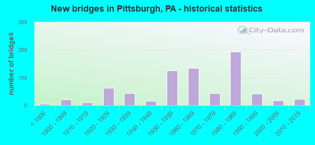
- New bridges - historical statistics
- 5Before 1900
- 211900-1909
- 101910-1919
- 631920-1929
- 431930-1939
- 161940-1949
- 1261950-1959
- 1341960-1969
- 441970-1979
- 1941980-1989
- 421990-1999
- 172000-2009
- 232010-2019
- 12020-2022
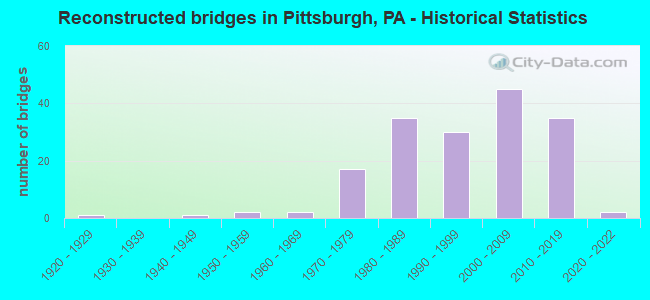
- Reconstructed bridges - Historical Statistics
- 11920-1929
- 01930-1939
- 11940-1949
- 21950-1959
- 21960-1969
- 171970-1979
- 351980-1989
- 301990-1999
- 452000-2009
- 352010-2019
- 22020-2022

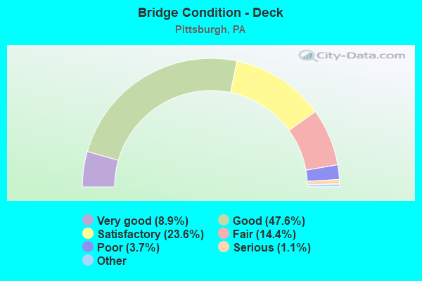
- Bridge Condition - Deck
- 8.9%Very good
- 47.6%Good
- 23.6%Satisfactory
- 14.4%Fair
- 3.7%Poor
- 1.1%Serious
- 0.7%Critical
- 0.4%Imminent failure
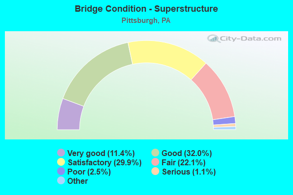
- Bridge Condition - Superstructure
- 11.4%Very good
- 32.0%Good
- 29.9%Satisfactory
- 22.1%Fair
- 2.5%Poor
- 1.1%Serious
- 1.1%Critical
- 0.7%Imminent failure
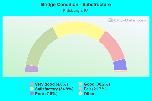
- Bridge Condition - Substructure
- 4.6%Excellent
- 30.2%Very good
- 34.9%Good
- 21.7%Satisfactory
- 7.5%Fair
- 1.1%Poor
- 0.7%Serious
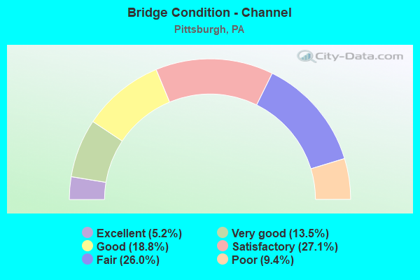
- Bridge Condition - Channel
- 5.2%Excellent
- 13.5%Very good
- 18.8%Good
- 27.1%Satisfactory
- 26.0%Fair
- 9.4%Poor
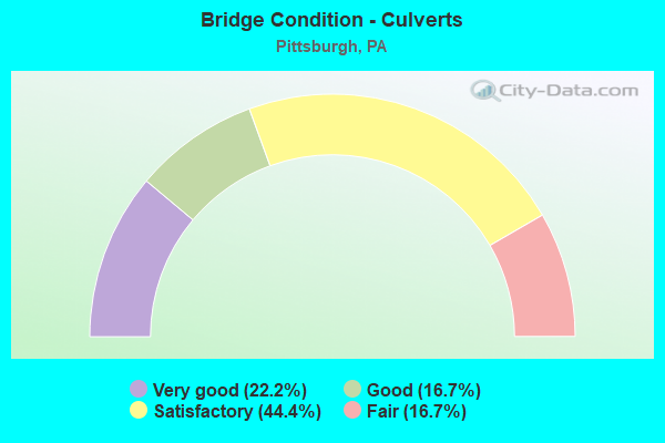
- Bridge Condition - Culverts
- 22.2%Very good
- 16.7%Good
- 44.4%Satisfactory
- 16.7%Fair
Find on map >> Show street view
Structure Number: 2023, Location: E. OHIO ST.UNDER SR 0579 (Lat: 40.454014, Lng: -79.997289), Route carried "under" structure: Interstate 279, Year Built: 1986, Structure Length: 0. m, Average Daily Traffic: 13,726 (year 2022), Truck Traffic: 8%, Features Intersected: I-279 NB-SB,& HOV, Facility Carried by Structure: EAST OHIO ST
Minimum Vertical Clearance: 4.70m (15.42ft), Kilometerpoint: 2.428, Lanes on structure: 4, Lanes under structure: 5, Material/Design: Steel continuous, Design/Construction: Stringer/Multi-beam, Length of Maximum Span: 34.1m (111.9ft)
Find on map >> Show street view
Structure Number: 2023, Location: E. OHIO ST.UNDER SR 0579 (Lat: 40.454014, Lng: -79.997289), Route carried "under" structure: Interstate 279, Year Built: 1986, Structure Length: 0. m, Average Daily Traffic: 586 (year 2021), Truck Traffic: 4%, Features Intersected: I-279 NB-SB,& HOV, Facility Carried by Structure: EAST OHIO ST
Minimum Vertical Clearance: 4.78m (15.68ft), Kilometerpoint: 1.006, Lanes on structure: 4, Lanes under structure: 5, Material/Design: Steel continuous, Design/Construction: Stringer/Multi-beam, Length of Maximum Span: 34.1m (111.9ft)
Find on map >> Show street view
Structure Number: 203, Location: Fort Duquesne Bridge (Lat: 40.448917, Lng: -80.006069), Route carried "under" structure: City street , Year Built: 1986, Structure Length: 0. m, Average Daily Traffic: 3,000 (year 1991), Truck Traffic: 1%, Features Intersected: FOUR CITY STREETS, Facility Carried by Structure: HOV
Minimum Vertical Clearance: 4.90m (16.08ft), Kilometerpoint: 0.000, Lanes on structure: 1, Lanes under structure: 13, Material/Design: Prestressed concrete continuous, Design/Construction: Stringer/Multi-beam, Length of Maximum Span: 36.0m (118.1ft)
Find on map >> Show street view
Structure Number: 203, Location: Fort Duquesne Bridge (Lat: 40.448917, Lng: -80.006069), Route carried "under" structure: City street , Year Built: 1986, Structure Length: 0. m, Average Daily Traffic: 3,000 (year 1991), Truck Traffic: 1%, Features Intersected: FOUR CITY STREETS, Facility Carried by Structure: HOV
Minimum Vertical Clearance: 5.51m (18.08ft), Kilometerpoint: 0.000, Lanes on structure: 1, Lanes under structure: 13, Material/Design: Prestressed concrete continuous, Design/Construction: Stringer/Multi-beam, Length of Maximum Span: 36.0m (118.1ft)
Find on map >> Show street view
Structure Number: 203, Location: Fort Duquesne Bridge (Lat: 40.448917, Lng: -80.006069), Route carried "under" structure: City street , Year Built: 1986, Structure Length: 0. m, Average Daily Traffic: 3,000 (year 1991), Truck Traffic: 1%, Features Intersected: FOUR CITY STREETS, Facility Carried by Structure: HOV
Minimum Vertical Clearance: 8.08m (26.51ft), Kilometerpoint: 0.000, Lanes on structure: 1, Lanes under structure: 13, Material/Design: Prestressed concrete continuous, Design/Construction: Stringer/Multi-beam, Length of Maximum Span: 36.0m (118.1ft)
Find on map >> Show street view
Structure Number: 203, Location: Fort Duquesne Bridge (Lat: 40.448917, Lng: -80.006069), Route carried "under" structure: City street , Year Built: 1986, Structure Length: 0. m, Average Daily Traffic: 3,000 (year 1991), Truck Traffic: 1%, Features Intersected: FOUR CITY STREETS, Facility Carried by Structure: HOV
Minimum Vertical Clearance: 6.38m (20.93ft), Kilometerpoint: 0.000, Lanes on structure: 1, Lanes under structure: 13, Material/Design: Prestressed concrete continuous, Design/Construction: Stringer/Multi-beam, Length of Maximum Span: 36.0m (118.1ft)
Find on map >> Show street view
Structure Number: 2032, Location: McKnight Interchange (Lat: 40.493583, Lng: -80.011117), Route carried "under" structure: State highway , Year Built: 1986, Structure Length: 0. m, Average Daily Traffic: 2,426 (year 2022), Truck Traffic: 4%, Features Intersected: RAMPJ, Facility Carried by Structure: HOV
Minimum Vertical Clearance: 11.58m (37.99ft), Kilometerpoint: 6.547, Lanes on structure: 2, Lanes under structure: 9, Material/Design: Steel continuous, Design/Construction: Stringer/Multi-beam, Length of Maximum Span: 47.2m (154.9ft)
Find on map >> Show street view
Structure Number: 2032, Location: McKnight Interchange (Lat: 40.493583, Lng: -80.011117), Route carried "under" structure: State highway 4003, Year Built: 1986, Structure Length: 0. m, Average Daily Traffic: 1,000 (year 2005), Truck Traffic: 7%, Features Intersected: RAMPJ, Facility Carried by Structure: HOV
Minimum Vertical Clearance: 10.95m (35.93ft), Kilometerpoint: 0.000, Lanes on structure: 2, Lanes under structure: 9, Material/Design: Steel continuous, Design/Construction: Stringer/Multi-beam, Length of Maximum Span: 47.2m (154.9ft)
Find on map >> Show street view
Structure Number: 2032, Location: McKnight Interchange (Lat: 40.493583, Lng: -80.011117), Route carried "under" structure: Ramp State highway , Year Built: 1986, Structure Length: 0. m, Average Daily Traffic: 12,747 (year 2021), Truck Traffic: 7%, Features Intersected: RAMPJ, Facility Carried by Structure: HOV
Minimum Vertical Clearance: 6.17m (20.24ft), Kilometerpoint: 0.000, Lanes on structure: 2, Lanes under structure: 9, Material/Design: Steel continuous, Design/Construction: Stringer/Multi-beam, Length of Maximum Span: 47.2m (154.9ft)
Find on map >> Show street view
Structure Number: 2032, Location: McKnight Interchange (Lat: 40.493583, Lng: -80.011117), Route carried "under" structure: State highway , Year Built: 1986, Structure Length: 0. m, Average Daily Traffic: 3,911 (year 2022), Truck Traffic: 2%, Features Intersected: RAMPJ, Facility Carried by Structure: HOV
Minimum Vertical Clearance: 11.58m (37.99ft), Kilometerpoint: 6.605, Lanes on structure: 2, Lanes under structure: 9, Material/Design: Steel continuous, Design/Construction: Stringer/Multi-beam, Length of Maximum Span: 47.2m (154.9ft)
Find on map >> Show street view
Structure Number: 2043, Location: Veterans Bridge (Lat: 40.443028, Lng: -79.991172), Route carried "under" structure: Ramp State highway , Year Built: 1986, Structure Length: 0. m, Average Daily Traffic: 7,250 (year 2021), Truck Traffic: 6%, Features Intersected: STATE RDS.,RR,CITY STS.., Facility Carried by Structure: HOV
Minimum Vertical Clearance: 10.82m (35.50ft), Kilometerpoint: 0.000, Lanes on structure: 2, Lanes under structure: 1, Material/Design: Steel continuous, Design/Construction: Stringer/Multi-beam, Length of Maximum Span: 64.0m (210.0ft)
Find on map >> Show street view
Structure Number: 2043, Location: Veterans Bridge (Lat: 40.443028, Lng: -79.991172), Route carried "under" structure: State highway 380, Year Built: 1986, Structure Length: 0. m, Average Daily Traffic: 7,665 (year 2022), Truck Traffic: 7%, Features Intersected: STATE RDS.,RR,CITY STS.., Facility Carried by Structure: HOV
Minimum Vertical Clearance: 4.79m (15.72ft), Kilometerpoint: 0.000, Lanes on structure: 2, Lanes under structure: 2, Material/Design: Steel continuous, Design/Construction: Stringer/Multi-beam, Length of Maximum Span: 64.0m (210.0ft)
Find on map >> Show street view
Structure Number: 2043, Location: Veterans Bridge (Lat: 40.443028, Lng: -79.991172), Route carried "under" structure: Interstate 579, Year Built: 1986, Structure Length: 0. m, Average Daily Traffic: 29,197 (year 2021), Truck Traffic: 5%, Features Intersected: STATE RDS.,RR,CITY STS.., Facility Carried by Structure: HOV
Minimum Vertical Clearance: 16.76m (54.99ft), Kilometerpoint: 0.000, Lanes on structure: 2, Lanes under structure: 2, Material/Design: Steel continuous, Design/Construction: Stringer/Multi-beam, Length of Maximum Span: 64.0m (210.0ft)
Find on map >> Show street view
Structure Number: 2043, Location: Veterans Bridge (Lat: 40.443028, Lng: -79.991172), Route carried "under" structure: Ramp State highway , Year Built: 1986, Structure Length: 0. m, Average Daily Traffic: 4,850 (year 2021), Truck Traffic: 2%, Features Intersected: STATE RDS.,RR,CITY STS.., Facility Carried by Structure: HOV
Minimum Vertical Clearance: 13.72m (45.01ft), Kilometerpoint: 0.000, Lanes on structure: 2, Lanes under structure: 1, Material/Design: Steel continuous, Design/Construction: Stringer/Multi-beam, Length of Maximum Span: 64.0m (210.0ft)
Find on map >> Show street view
Structure Number: 2043, Location: Veterans Bridge (Lat: 40.443028, Lng: -79.991172), Route carried "under" structure: State highway 380, Year Built: 1986, Structure Length: 0. m, Average Daily Traffic: 10,523 (year 2022), Truck Traffic: 7%, Features Intersected: STATE RDS.,RR,CITY STS.., Facility Carried by Structure: HOV
Minimum Vertical Clearance: 4.79m (15.72ft), Kilometerpoint: 0.000, Lanes on structure: 2, Lanes under structure: 6, Material/Design: Steel continuous, Design/Construction: Stringer/Multi-beam, Length of Maximum Span: 64.0m (210.0ft)
Find on map >> Show street view
Structure Number: 2044, Location: Veterans Bridge (Lat: 40.452722, Lng: -79.996458), Route carried "under" structure: State highway , Year Built: 1988, Structure Length: 0. m, Average Daily Traffic: 14,888 (year 2021), Truck Traffic: 7%, Features Intersected: NS RAILWAY, Facility Carried by Structure: HOV
Minimum Vertical Clearance: 30+ m (98+ ft), Kilometerpoint: 0.000, Lanes on structure: 1, Lanes under structure: 1, Material/Design: Prestressed concrete continuous, Design/Construction: Stringer/Multi-beam, Length of Maximum Span: 32.9m (107.9ft)
Find on map >> Show street view
Structure Number: 2044, Location: Veterans Bridge (Lat: 40.452722, Lng: -79.996458), Route carried "under" structure: Interstate 279, Year Built: 1988, Structure Length: 0. m, Average Daily Traffic: 13,726 (year 2022), Truck Traffic: 8%, Features Intersected: NS RAILWAY, Facility Carried by Structure: HOV
Minimum Vertical Clearance: 30+ m (98+ ft), Kilometerpoint: 1.754, Lanes on structure: 1, Lanes under structure: 2, Material/Design: Prestressed concrete continuous, Design/Construction: Stringer/Multi-beam, Length of Maximum Span: 32.9m (107.9ft)
Find on map >> Show street view
Structure Number: 2044, Location: Veterans Bridge (Lat: 40.452722, Lng: -79.996458), Route carried "under" structure: State highway 28, Year Built: 1988, Structure Length: 0. m, Average Daily Traffic: 7,220 (year 2022), Truck Traffic: 3%, Features Intersected: NS RAILWAY, Facility Carried by Structure: HOV
Minimum Vertical Clearance: 13.05m (42.81ft), Kilometerpoint: 0.571, Lanes on structure: 1, Lanes under structure: 2, Material/Design: Prestressed concrete continuous, Design/Construction: Stringer/Multi-beam, Length of Maximum Span: 32.9m (107.9ft)
Find on map >> Show street view
Structure Number: 2044, Location: Veterans Bridge (Lat: 40.452722, Lng: -79.996458), Route carried "under" structure: State highway , Year Built: 1988, Structure Length: 0. m, Average Daily Traffic: 11,236 (year 2022), Truck Traffic: 9%, Features Intersected: NS RAILWAY, Facility Carried by Structure: HOV
Minimum Vertical Clearance: 4.50m (14.76ft), Kilometerpoint: 0.021, Lanes on structure: 1, Lanes under structure: 2, Material/Design: Prestressed concrete continuous, Design/Construction: Stringer/Multi-beam, Length of Maximum Span: 32.9m (107.9ft)
Find on map >> Show street view
Structure Number: 2044, Location: Veterans Bridge (Lat: 40.452722, Lng: -79.996458), Route carried "under" structure: Ramp State highway , Year Built: 1988, Structure Length: 0. m, Average Daily Traffic: 9,115 (year 2021), Truck Traffic: 5%, Features Intersected: NS RAILWAY, Facility Carried by Structure: HOV
Minimum Vertical Clearance: 6.86m (22.51ft), Kilometerpoint: 0.000, Lanes on structure: 1, Lanes under structure: 1, Material/Design: Prestressed concrete continuous, Design/Construction: Stringer/Multi-beam, Length of Maximum Span: 32.9m (107.9ft)
Find on map >> Show street view
Structure Number: 2044, Location: Veterans Bridge (Lat: 40.452722, Lng: -79.996458), Route carried "under" structure: State highway , Year Built: 1988, Structure Length: 0. m, Average Daily Traffic: 10,936 (year 2022), Truck Traffic: 7%, Features Intersected: NS RAILWAY, Facility Carried by Structure: HOV
Minimum Vertical Clearance: 4.50m (14.76ft), Kilometerpoint: 0.021, Lanes on structure: 1, Lanes under structure: 2, Material/Design: Prestressed concrete continuous, Design/Construction: Stringer/Multi-beam, Length of Maximum Span: 32.9m (107.9ft)
Find on map >> Show street view
Structure Number: 2044, Location: Veterans Bridge (Lat: 40.452722, Lng: -79.996458), Route carried "under" structure: State highway 28, Year Built: 1988, Structure Length: 0. m, Average Daily Traffic: 11,707 (year 2022), Truck Traffic: 3%, Features Intersected: NS RAILWAY, Facility Carried by Structure: HOV
Minimum Vertical Clearance: 18.21m (59.74ft), Kilometerpoint: 0.000, Lanes on structure: 1, Lanes under structure: 2, Material/Design: Prestressed concrete continuous, Design/Construction: Stringer/Multi-beam, Length of Maximum Span: 32.9m (107.9ft)
Find on map >> Show street view
Structure Number: 2381, Location: AL02 6 ST TO NORTH SIDE (Lat: 40.445497, Lng: -80.003300), Route carried "under" structure: Business State highway , Year Built: 1928, Structure Length: 0. m, Average Daily Traffic: 8,791 (year 2022), Truck Traffic: 6%, Features Intersected: 10TH ST BYPASS,ALLEGH RV, Facility Carried by Structure: SIXTH STREET BR
Minimum Vertical Clearance: 4.78m (15.68ft), Kilometerpoint: 0.000, Lanes on structure: 4, Lanes under structure: 4, Material/Design: Steel continuous, Design/Construction: Suspension, Length of Maximum Span: 131.1m (430.1ft)
Find on map >> Show street view
Structure Number: 2381, Location: AL02 6 ST TO NORTH SIDE (Lat: 40.445497, Lng: -80.003300), Route carried "under" structure: Business State highway , Year Built: 1928, Structure Length: 0. m, Average Daily Traffic: 10,570 (year 2022), Truck Traffic: 3%, Features Intersected: 10TH ST BYPASS,ALLEGH RV, Facility Carried by Structure: SIXTH STREET BR
Minimum Vertical Clearance: 4.78m (15.68ft), Kilometerpoint: 0.000, Lanes on structure: 4, Lanes under structure: 4, Material/Design: Steel continuous, Design/Construction: Suspension, Length of Maximum Span: 131.1m (430.1ft)
Find on map >> Show street view
Structure Number: 2382, Location: AL03 7TH ST BRIDGE (Lat: 40.446222, Lng: -80.001456), Route carried "under" structure: Bypass State highway , Year Built: 1926, Structure Length: 0. m, Average Daily Traffic: 8,791 (year 2022), Truck Traffic: 6%, Features Intersected: ALLEGH RIV,10 ST BY-PASS, Facility Carried by Structure: SEVENTH STREET BR
Minimum Vertical Clearance: 4.65m (15.26ft), Kilometerpoint: 0.000, Lanes on structure: 3, Lanes under structure: 2, Material/Design: Steel continuous, Design/Construction: Suspension, Length of Maximum Span: 134.7m (441.9ft)
Find on map >> Show street view
Structure Number: 2382, Location: AL03 7TH ST BRIDGE (Lat: 40.446222, Lng: -80.001456), Route carried "under" structure: Bypass State highway , Year Built: 1926, Structure Length: 0. m, Average Daily Traffic: 10,570 (year 2022), Truck Traffic: 3%, Features Intersected: ALLEGH RIV,10 ST BY-PASS, Facility Carried by Structure: SEVENTH STREET BR
Minimum Vertical Clearance: 4.65m (15.26ft), Kilometerpoint: 0.000, Lanes on structure: 3, Lanes under structure: 2, Material/Design: Steel continuous, Design/Construction: Suspension, Length of Maximum Span: 134.7m (441.9ft)
Find on map >> Show street view
Structure Number: 2383, Location: AL04 9TH ST BRIDGE (Lat: 40.446600, Lng: -79.999700), Route carried "under" structure: Bypass State highway , Year Built: 1926, Structure Length: 0. m, Average Daily Traffic: 10,570 (year 2022), Truck Traffic: 3%, Features Intersected: ALLEGH RIV,10 ST BY-PASS, Facility Carried by Structure: NINTH STREET BR
Minimum Vertical Clearance: 4.70m (15.42ft), Kilometerpoint: 0.000, Lanes on structure: 4, Lanes under structure: 2, Material/Design: Steel continuous, Design/Construction: Suspension, Length of Maximum Span: 131.1m (430.1ft)
Find on map >> Show street view
Structure Number: 2383, Location: AL04 9TH ST BRIDGE (Lat: 40.446600, Lng: -79.999700), Route carried "under" structure: Bypass State highway , Year Built: 1926, Structure Length: 0. m, Average Daily Traffic: 8,791 (year 2022), Truck Traffic: 6%, Features Intersected: ALLEGH RIV,10 ST BY-PASS, Facility Carried by Structure: NINTH STREET BR
Minimum Vertical Clearance: 4.70m (15.42ft), Kilometerpoint: 0.000, Lanes on structure: 4, Lanes under structure: 2, Material/Design: Steel continuous, Design/Construction: Suspension, Length of Maximum Span: 131.1m (430.1ft)
Find on map >> Show street view
Structure Number: 2384, Location: AL05 16TH ST BRIDGE (Lat: 40.451597, Lng: -79.990800), Route carried "under" structure: City street , Year Built: 1922, Structure Length: 0. m, Average Daily Traffic: 50 (year 2006), Features Intersected: SMALLMAN ST, ALLEG. RIV., Facility Carried by Structure: SIXTEENTHSTREET BR
Minimum Vertical Clearance: 30+ m (98+ ft), Kilometerpoint: 0.000, Lanes on structure: 4, Lanes under structure: 6, Material/Design: Steel, Design/Construction: Arch - Thru, Length of Maximum Span: 133.2m (437.0ft)
Find on map >> Show street view
Structure Number: 2384, Location: AL05 16TH ST BRIDGE (Lat: 40.451597, Lng: -79.990800), Route carried "under" structure: City street , Year Built: 1922, Structure Length: 0. m, Average Daily Traffic: 50 (year 2006), Features Intersected: SMALLMAN ST, ALLEG. RIV., Facility Carried by Structure: SIXTEENTHSTREET BR
Minimum Vertical Clearance: 6.10m (20.01ft), Kilometerpoint: 0.000, Lanes on structure: 4, Lanes under structure: 6, Material/Design: Steel, Design/Construction: Arch - Thru, Length of Maximum Span: 133.2m (437.0ft)
Find on map >> Show street view
Structure Number: 2384, Location: AL05 16TH ST BRIDGE (Lat: 40.451597, Lng: -79.990800), Route carried "under" structure: City street , Year Built: 1922, Structure Length: 0. m, Average Daily Traffic: 50 (year 2006), Features Intersected: SMALLMAN ST, ALLEG. RIV., Facility Carried by Structure: SIXTEENTHSTREET BR
Minimum Vertical Clearance: 4.57m (14.99ft), Kilometerpoint: 0.000, Lanes on structure: 4, Lanes under structure: 6, Material/Design: Steel, Design/Construction: Arch - Thru, Length of Maximum Span: 133.2m (437.0ft)
Find on map >> Show street view
Structure Number: 2385, Location: CC02 CHARTIERS CRK # 2 (Lat: 40.464011, Lng: -80.074794), Route carried "under" structure: ServiceCity street , Year Built: 1985, Structure Length: 0. m, Average Daily Traffic: 50 (year 2005), Features Intersected: EDMORE&CRKRD,RR'S&CHARCK, Facility Carried by Structure: WINDGAP AV
Minimum Vertical Clearance: 5.97m (19.59ft), Kilometerpoint: 0.000, Lanes on structure: 2, Lanes under structure: 2, Material/Design: Steel, Design/Construction: Stringer/Multi-beam, Length of Maximum Span: 45.7m (149.9ft)
Find on map >> Show street view
Structure Number: 2385, Location: CC02 CHARTIERS CRK # 2 (Lat: 40.464011, Lng: -80.074794), Route carried "under" structure: ServiceCity street , Year Built: 1985, Structure Length: 0. m, Average Daily Traffic: 50 (year 2005), Features Intersected: EDMORE&CRKRD,RR'S&CHARCK, Facility Carried by Structure: WINDGAP AV
Minimum Vertical Clearance: 13.44m (44.09ft), Kilometerpoint: 0.000, Lanes on structure: 2, Lanes under structure: 2, Material/Design: Steel, Design/Construction: Stringer/Multi-beam, Length of Maximum Span: 45.7m (149.9ft)
Find on map >> Show street view
Structure Number: 2386, Location: IV01 IVORY AVENUE NO. 1 (Lat: 40.496756, Lng: -80.012511), Route carried "under" structure: Ramp Interstate 279, Year Built: 1986, Structure Length: 0. m, Average Daily Traffic: 5,500 (year 2005), Truck Traffic: 6%, Features Intersected: I279 RAMP J & TRUCK US19, Facility Carried by Structure: IVORY AV
Minimum Vertical Clearance: 7.47m (24.51ft), Kilometerpoint: 0.000, Lanes on structure: 2, Lanes under structure: 5, Material/Design: Steel, Design/Construction: Stringer/Multi-beam, Length of Maximum Span: 54.9m (180.1ft)
Find on map >> Show street view
Structure Number: 2386, Location: IV01 IVORY AVENUE NO. 1 (Lat: 40.496756, Lng: -80.012511), Route carried "under" structure: US 19T, Year Built: 1986, Structure Length: 0. m, Average Daily Traffic: 16,461 (year 2022), Truck Traffic: 2%, Features Intersected: I279 RAMP J & TRUCK US19, Facility Carried by Structure: IVORY AV
Minimum Vertical Clearance: 7.62m (25.00ft), Kilometerpoint: 0.919, Lanes on structure: 2, Lanes under structure: 5, Material/Design: Steel, Design/Construction: Stringer/Multi-beam, Length of Maximum Span: 54.9m (180.1ft)
Find on map >> Show street view
Structure Number: 2386, Location: IV01 IVORY AVENUE NO. 1 (Lat: 40.496756, Lng: -80.012511), Route carried "under" structure: US 19T, Year Built: 1986, Structure Length: 0. m, Average Daily Traffic: 21,149 (year 2022), Truck Traffic: 2%, Features Intersected: I279 RAMP J & TRUCK US19, Facility Carried by Structure: IVORY AV
Minimum Vertical Clearance: 7.62m (25.00ft), Kilometerpoint: 0.916, Lanes on structure: 2, Lanes under structure: 5, Material/Design: Steel, Design/Construction: Stringer/Multi-beam, Length of Maximum Span: 54.9m (180.1ft)
Find on map >> Show street view
Structure Number: 2387, Location: JA01 JACKS RUN NO 1 (Lat: 40.488300, Lng: -80.046039), Route carried "under" structure: City street , Year Built: 1925, Structure Length: 0. m, Average Daily Traffic: 100 (year 2006), Truck Traffic: 5%, Features Intersected: FARRAGUT ST, JACKS RUN, Facility Carried by Structure: CALIFORNIA AVENUE
Minimum Vertical Clearance: 30+ m (98+ ft), Kilometerpoint: 0.000, Lanes on structure: 2, Lanes under structure: 2, Material/Design: Concrete, Design/Construction: Arch - Deck, Length of Maximum Span: 97.5m (319.9ft)
Find on map >> Show street view
Structure Number: 2388, Location: MA11 SOUTH 10TH ST BRDG (Lat: 40.432736, Lng: -79.989308), Route carried "under" structure: Interstate 376, Year Built: 1933, Structure Length: 0. m, Average Daily Traffic: 42,465 (year 2022), Truck Traffic: 6%, Features Intersected: I376 AND CSX RR, Facility Carried by Structure: TENTH STREET BR
Minimum Vertical Clearance: 6.10m (20.01ft), Kilometerpoint: 35.095, Lanes on structure: 4, Lanes under structure: 3, Material/Design: Steel, Design/Construction: Suspension, Length of Maximum Span: 221.0m (725.1ft)
Find on map >> Show street view
Structure Number: 2389, Location: OK03 OAKWOOD RUN NO. 3 (Lat: 40.429758, Lng: -80.066253), Route carried "under" structure: City street , Year Built: 1984, Structure Length: 0. m, Average Daily Traffic: 50 (year 2021), Truck Traffic: 3%, Features Intersected: PENSDALE ST,OAKWOOD RUN, Facility Carried by Structure: OAKWOOD RD
Minimum Vertical Clearance: 3.96m (12.99ft), Kilometerpoint: 0.000, Lanes on structure: 2, Lanes under structure: 2, Material/Design: Steel continuous, Design/Construction: Stringer/Multi-beam, Length of Maximum Span: 42.1m (138.1ft)
Find on map >> Show street view
Structure Number: 2397, Location: 301009 BIGELOW BLVD UNPSS (Lat: 40.458842, Lng: -79.957622), Route carried "under" structure: Ramp City street , Year Built: 1986, Structure Length: 0. m, Average Daily Traffic: 6,100 (year 2020), Truck Traffic: 5%, Features Intersected: BLOOMFIELD BRIDGE RAMP F, Facility Carried by Structure: BIGELOW BV
Minimum Vertical Clearance: 4.42m (14.50ft), Kilometerpoint: 0.000, Lanes on structure: 4, Lanes under structure: 1, Material/Design: Concrete, Design/Construction: Culvert, Length of Maximum Span: 8.2m (26.9ft)
Find on map >> Show street view
Structure Number: 2398, Location: 301010 BLOOMFIELD BRIDGE (Lat: 40.460636, Lng: -79.955969), Route carried "under" structure: Other road , Year Built: 1986, Structure Length: 0. m, Features Intersected: N-S RR,CSX RR,E BSWY,PL, Facility Carried by Structure: BLOOMFIELD BR
Minimum Vertical Clearance: 30+ m (98+ ft), Kilometerpoint: 0.000, Lanes on structure: 4, Lanes under structure: 2, Material/Design: Steel continuous, Design/Construction: Stringer/Multi-beam, Length of Maximum Span: 91.4m (299.9ft)
Find on map >> Show street view
Structure Number: 2402, Location: 301020 NEAR INT/STRAKA ST (Lat: 40.452858, Lng: -80.054553), Route carried "under" structure: Other road , Year Built: 1908, Structure Length: 0. m, Average Daily Traffic: 1,000 (year 2021), Features Intersected: PAT AIRPORT BUSWAY, Facility Carried by Structure: CHARTIERS AV
Minimum Vertical Clearance: 6.10m (20.01ft), Kilometerpoint: 0.000, Lanes on structure: 2, Lanes under structure: 2, Material/Design: Steel, Design/Construction: Stringer/Multi-beam, Length of Maximum Span: 10.4m (34.1ft)
Find on map >> Show street view
Structure Number: 2409, Location: 200' WEST OF 2ND ST (Lat: 40.406986, Lng: -79.944050), Route carried "under" structure: City street , Year Built: 1900, Structure Length: 0. m, Average Daily Traffic: 300 (year 2020), Truck Traffic: 5%, Features Intersected: CSX RR,GLOSTER ST, Facility Carried by Structure: ELIZABETH ST
Minimum Vertical Clearance: 5.80m (19.03ft), Kilometerpoint: 0.000, Lanes on structure: 2, Lanes under structure: 2, Material/Design: Steel, Design/Construction: Stringer/Multi-beam, Length of Maximum Span: 25.0m (82.0ft)
Find on map >> Show street view
Structure Number: 2411, Location: 301034 NEAR CRAIG (Lat: 40.444553, Lng: -79.946803), Route carried "under" structure: City street , Year Built: 1900, Structure Length: 0. m, Average Daily Traffic: 1,700 (year 1999), Truck Traffic: 4%, Features Intersected: CSX RR, BOUNDARY ST, Facility Carried by Structure: FORBES AV
Minimum Vertical Clearance: 13.62m (44.69ft), Kilometerpoint: 0.000, Lanes on structure: 2, Lanes under structure: 2, Material/Design: Steel, Design/Construction: Stringer/Multi-beam, Length of Maximum Span: 45.7m (149.9ft)
Find on map >> Show street view
Structure Number: 2416, Location: 301040 AT LIBERTY AVE (Lat: 40.460478, Lng: -79.966625), Route carried "under" structure: Other road , Year Built: 1980, Structure Length: 0. m, Average Daily Traffic: 4,000 (year 2004), Truck Traffic: 5%, Features Intersected: NSRC, CSX & BUSWAY, Facility Carried by Structure: HERRON AV
Minimum Vertical Clearance: 6.49m (21.29ft), Kilometerpoint: 0.000, Lanes on structure: 2, Lanes under structure: 2, Material/Design: Steel continuous, Design/Construction: Stringer/Multi-beam, Length of Maximum Span: 39.6m (129.9ft)
Find on map >> Show street view
Structure Number: 2419, Location: 301047 OV WASHINGTON BLVD (Lat: 40.467508, Lng: -79.908769), Route carried "under" structure: State highway 8, Year Built: 1912, Structure Length: 0. m, Average Daily Traffic: 15,705 (year 2022), Truck Traffic: 3%, Features Intersected: WASHINGTON BLVD (RT 8), Facility Carried by Structure: LARIMER AV
Minimum Vertical Clearance: 23.04m (75.59ft), Kilometerpoint: 5.066, Lanes on structure: 2, Lanes under structure: 2, Material/Design: Concrete, Design/Construction: Arch - Deck, Length of Maximum Span: 91.4m (299.9ft)
Find on map >> Show street view
Structure Number: 2419, Location: 301047 OV WASHINGTON BLVD (Lat: 40.467508, Lng: -79.908769), Route carried "under" structure: State highway 8, Year Built: 1912, Structure Length: 0. m, Average Daily Traffic: 14,001 (year 2022), Truck Traffic: 3%, Features Intersected: WASHINGTON BLVD (RT 8), Facility Carried by Structure: LARIMER AV
Minimum Vertical Clearance: 23.04m (75.59ft), Kilometerpoint: 5.066, Lanes on structure: 2, Lanes under structure: 2, Material/Design: Concrete, Design/Construction: Arch - Deck, Length of Maximum Span: 91.4m (299.9ft)
Find on map >> Show street view
Structure Number: 242, Location: 301048 IN EAST LIBERTY (Lat: 40.462750, Lng: -79.905486), Route carried "under" structure: State highway 8, Year Built: 1905, Structure Length: 0. m, Average Daily Traffic: 15,705 (year 2022), Truck Traffic: 3%, Features Intersected: WASHINGTON BLVD (RT 8), Facility Carried by Structure: LINCOLN AV
Minimum Vertical Clearance: 13.44m (44.09ft), Kilometerpoint: 5.066, Lanes on structure: 2, Lanes under structure: 2, Material/Design: Masonry, Design/Construction: Arch - Deck, Length of Maximum Span: 39.6m (129.9ft)
Find on map >> Show street view
Structure Number: 242, Location: 301048 IN EAST LIBERTY (Lat: 40.462750, Lng: -79.905486), Route carried "under" structure: State highway 8, Year Built: 1905, Structure Length: 0. m, Average Daily Traffic: 14,001 (year 2022), Truck Traffic: 3%, Features Intersected: WASHINGTON BLVD (RT 8), Facility Carried by Structure: LINCOLN AV
Minimum Vertical Clearance: 13.44m (44.09ft), Kilometerpoint: 5.066, Lanes on structure: 2, Lanes under structure: 2, Material/Design: Masonry, Design/Construction: Arch - Deck, Length of Maximum Span: 39.6m (129.9ft)
Find on map >> Show street view
Structure Number: 2421, Location: 301050 OVER RIALTO STREET (Lat: 40.465722, Lng: -79.981217), Route carried "under" structure: City street , Year Built: 1900, Structure Length: 0. m, Average Daily Traffic: 550 (year 2021), Truck Traffic: 3%, Features Intersected: RIALTO STREET, Facility Carried by Structure: LOWRIE ST
Minimum Vertical Clearance: 4.15m (13.62ft), Kilometerpoint: 0.000, Lanes on structure: 2, Lanes under structure: 2, Material/Design: Prestressed concrete, Design/Construction: Box Beam or Girders - Multiple, Length of Maximum Span: 14.3m (46.9ft)
Find on map >> Show street view
Structure Number: 2422, Location: 301051 OVER N CHARLES ST (Lat: 40.471144, Lng: -80.007903), Route carried "under" structure: City street , Year Built: 1929, Structure Length: 0. m, Average Daily Traffic: 5,700 (year 2021), Truck Traffic: 6%, Features Intersected: N CHARLES STREET, Facility Carried by Structure: MAPLE AVENUE
Minimum Vertical Clearance: 4.17m (13.68ft), Kilometerpoint: 0.000, Lanes on structure: 2, Lanes under structure: 2, Material/Design: Steel, Design/Construction: Stringer/Multi-beam, Length of Maximum Span: 11.6m (38.1ft)
Find on map >> Show street view
Structure Number: 2423, Location: 301052 ROBERT MCAFEE BRDG (Lat: 40.472017, Lng: -80.037217), Route carried "under" structure: City street , Year Built: 1928, Structure Length: 0. m, Average Daily Traffic: 600 (year 2021), Truck Traffic: 5%, Features Intersected: MCCLURE AVE, ECKERT ST, Facility Carried by Structure: CALIFORNIA AVENUE
Minimum Vertical Clearance: 10.70m (35.10ft), Kilometerpoint: 0.000, Lanes on structure: 2, Lanes under structure: 2, Material/Design: Steel, Design/Construction: Truss - Deck, Length of Maximum Span: 114.3m (375.0ft)
Find on map >> Show street view
Structure Number: 2423, Location: 301052 ROBERT MCAFEE BRDG (Lat: 40.472017, Lng: -80.037217), Route carried "under" structure: City street , Year Built: 1928, Structure Length: 0. m, Average Daily Traffic: 250 (year 2021), Truck Traffic: 5%, Features Intersected: MCCLURE AVE, ECKERT ST, Facility Carried by Structure: CALIFORNIA AVENUE
Minimum Vertical Clearance: 22.59m (74.11ft), Kilometerpoint: 0.000, Lanes on structure: 2, Lanes under structure: 2, Material/Design: Steel, Design/Construction: Truss - Deck, Length of Maximum Span: 114.3m (375.0ft)
Find on map >> Show street view
Structure Number: 2424, Location: 301053 P.J. MCARDLE RDWY (Lat: 40.430419, Lng: -80.002300), Route carried "under" structure: City street , Year Built: 1983, Structure Length: 0. m, Average Daily Traffic: 700 (year 2001), Truck Traffic: 5%, Features Intersected: SYCAMORE STREET, Facility Carried by Structure: MCARDLE RDWY RD
Minimum Vertical Clearance: 10.97m (35.99ft), Kilometerpoint: 0.000, Lanes on structure: 2, Lanes under structure: 2, Material/Design: Steel continuous, Design/Construction: Stringer/Multi-beam, Length of Maximum Span: 56.4m (185.0ft)
Find on map >> Show street view
Structure Number: 2426, Location: 301057 MEADOW STREET BRDG (Lat: 40.466869, Lng: -79.916028), Route carried "under" structure: City street , Year Built: 1914, Structure Length: 0. m, Average Daily Traffic: 4,000 (year 2020), Truck Traffic: 7%, Features Intersected: NEGLEY RUN BLVD, Facility Carried by Structure: MEADOW ST
Minimum Vertical Clearance: 15.24m (50.00ft), Kilometerpoint: 0.000, Lanes on structure: 2, Lanes under structure: 4, Material/Design: Concrete, Design/Construction: Arch - Deck, Length of Maximum Span: 64.9m (212.9ft)
Find on map >> Show street view
Structure Number: 2427, Location: 301060 MISSION ST EAST (Lat: 40.423261, Lng: -79.974319), Route carried "under" structure: City street , Year Built: 1939, Structure Length: 0. m, Average Daily Traffic: 100 (year 2020), Truck Traffic: 4%, Features Intersected: GOMER AND GREELY STREETS, Facility Carried by Structure: MISSION ST
Minimum Vertical Clearance: 6.35m (20.83ft), Kilometerpoint: 0.000, Lanes on structure: 2, Lanes under structure: 2, Material/Design: Steel continuous, Design/Construction: Girder and Floorbeam System, Length of Maximum Span: 28.3m (92.8ft)
Find on map >> Show street view
Structure Number: 2427, Location: 301060 MISSION ST EAST (Lat: 40.423261, Lng: -79.974319), Route carried "under" structure: City street , Year Built: 1939, Structure Length: 0. m, Average Daily Traffic: 50 (year 2020), Truck Traffic: 4%, Features Intersected: GOMER AND GREELY STREETS, Facility Carried by Structure: MISSION ST
Minimum Vertical Clearance: 9.63m (31.59ft), Kilometerpoint: 0.000, Lanes on structure: 2, Lanes under structure: 2, Material/Design: Steel continuous, Design/Construction: Girder and Floorbeam System, Length of Maximum Span: 28.3m (92.8ft)
Find on map >> Show street view
Structure Number: 2428, Location: 301061 MISSION ST WEST (Lat: 40.423631, Lng: -79.976878), Route carried "under" structure: City street , Year Built: 1939, Structure Length: 0. m, Average Daily Traffic: 200 (year 2020), Truck Traffic: 4%, Features Intersected: SOUTH 21ST STREET, Facility Carried by Structure: MISSION ST
Minimum Vertical Clearance: 14.26m (46.78ft), Kilometerpoint: 0.000, Lanes on structure: 2, Lanes under structure: 2, Material/Design: Steel continuous, Design/Construction: Girder and Floorbeam System, Length of Maximum Span: 48.8m (160.1ft)
Find on map >> Show street view
Structure Number: 2431, Location: 301066 OV BEECHWOOD BLVD (Lat: 40.427053, Lng: -79.926903), Route carried "under" structure: Ramp State highway , Year Built: 1978, Structure Length: 0. m, Average Daily Traffic: 10,596 (year 2021), Truck Traffic: 7%, Features Intersected: BEECHWOOD BLVD,PKWY RAMP, Facility Carried by Structure: MURRAY AV
Minimum Vertical Clearance: 16.97m (55.68ft), Kilometerpoint: 0.000, Lanes on structure: 2, Lanes under structure: 3, Material/Design: Steel continuous, Design/Construction: Frame, Length of Maximum Span: 50.6m (166.0ft)
Find on map >> Show street view
Structure Number: 2431, Location: 301066 OV BEECHWOOD BLVD (Lat: 40.427053, Lng: -79.926903), Route carried "under" structure: City street , Year Built: 1978, Structure Length: 0. m, Average Daily Traffic: 8,000 (year 2003), Truck Traffic: 5%, Features Intersected: BEECHWOOD BLVD,PKWY RAMP, Facility Carried by Structure: MURRAY AV
Minimum Vertical Clearance: 12.93m (42.42ft), Kilometerpoint: 0.000, Lanes on structure: 2, Lanes under structure: 3, Material/Design: Steel continuous, Design/Construction: Frame, Length of Maximum Span: 50.6m (166.0ft)
Find on map >> Show street view
Structure Number: 2438, Location: 301084 BT FORBES&PHIPPS C (Lat: 40.441367, Lng: -79.949328), Route carried "under" structure: City street , Year Built: 1896, Structure Length: 0. m, Average Daily Traffic: 2,400 (year 2003), Truck Traffic: 5%, Features Intersected: CSX RAILROAD,BOUNDARY ST, Facility Carried by Structure: SCHENLEY DR
Minimum Vertical Clearance: 22.91m (75.16ft), Kilometerpoint: 0.000, Lanes on structure: 4, Lanes under structure: 2, Material/Design: Steel, Design/Construction: Truss - Deck, Length of Maximum Span: 109.7m (359.9ft)
Find on map >> Show street view
Structure Number: 244, Location: 301086 SCHENLEY PK UNDPSS (Lat: 40.435342, Lng: -79.946622), Route carried "under" structure: City street , Year Built: 1988, Structure Length: 0. m, Average Daily Traffic: 600 (year 2020), Truck Traffic: 3%, Features Intersected: OVERLOOK DRIVE, Facility Carried by Structure: PANTHER HOLLOW RD
Minimum Vertical Clearance: 4.19m (13.75ft), Kilometerpoint: 0.000, Lanes on structure: 4, Lanes under structure: 2, Material/Design: Prestressed concrete, Design/Construction: Box Beam or Girders - Multiple, Length of Maximum Span: 17.4m (57.1ft)
Find on map >> Show street view
Structure Number: 2448, Location: 301095 SHADELAND AVE (Lat: 40.476272, Lng: -80.032819), Route carried "under" structure: City street , Year Built: 1993, Structure Length: 0. m, Average Daily Traffic: 4,000 (year 2021), Truck Traffic: 5%, Features Intersected: WOODS RUN RD, LECKY WAY, Facility Carried by Structure: SHADELAND AVENUE
Minimum Vertical Clearance: 30+ m (98+ ft), Kilometerpoint: 0.000, Lanes on structure: 2, Lanes under structure: 2, Material/Design: Steel continuous, Design/Construction: Stringer/Multi-beam, Length of Maximum Span: 50.6m (166.0ft)
Find on map >> Show street view
Structure Number: 2448, Location: 301095 SHADELAND AVE (Lat: 40.476272, Lng: -80.032819), Route carried "under" structure: City street , Year Built: 1993, Structure Length: 0. m, Average Daily Traffic: 1,300 (year 2021), Truck Traffic: 5%, Features Intersected: WOODS RUN RD, LECKY WAY, Facility Carried by Structure: SHADELAND AVENUE
Minimum Vertical Clearance: 30+ m (98+ ft), Kilometerpoint: 0.000, Lanes on structure: 2, Lanes under structure: 2, Material/Design: Steel continuous, Design/Construction: Stringer/Multi-beam, Length of Maximum Span: 50.6m (166.0ft)
Find on map >> Show street view
Structure Number: 2448, Location: 301095 SHADELAND AVE (Lat: 40.476272, Lng: -80.032819), Route carried "under" structure: City street , Year Built: 1993, Structure Length: 0. m, Average Daily Traffic: 40 (year 2021), Truck Traffic: 5%, Features Intersected: WOODS RUN RD, LECKY WAY, Facility Carried by Structure: SHADELAND AVENUE
Minimum Vertical Clearance: 8.53m (27.99ft), Kilometerpoint: 0.000, Lanes on structure: 2, Lanes under structure: 2, Material/Design: Steel continuous, Design/Construction: Stringer/Multi-beam, Length of Maximum Span: 50.6m (166.0ft)
Find on map >> Show street view
Structure Number: 2452, Location: 301101 S MILLVALE AVE BRG (Lat: 40.457022, Lng: -79.947606), Route carried "under" structure: City street , Year Built: 1927, Structure Length: 0. m, Average Daily Traffic: 200 (year 2006), Truck Traffic: 6%, Features Intersected: N-S RR,E BUSWAY,GROSS ST, Facility Carried by Structure: SOUTH MILLVALE AV
Minimum Vertical Clearance: 15.42m (50.59ft), Kilometerpoint: 0.000, Lanes on structure: 2, Lanes under structure: 3, Material/Design: Steel, Design/Construction: Girder and Floorbeam System, Length of Maximum Span: 27.4m (89.9ft)
Find on map >> Show street view
Structure Number: 2452, Location: 301101 S MILLVALE AVE BRG (Lat: 40.457022, Lng: -79.947606), Route carried "under" structure: Other road , Year Built: 1927, Structure Length: 0. m, Average Daily Traffic: 4,000 (year 2006), Features Intersected: N-S RR,E BUSWAY,GROSS ST, Facility Carried by Structure: SOUTH MILLVALE AV
Minimum Vertical Clearance: 16.31m (53.51ft), Kilometerpoint: 0.000, Lanes on structure: 2, Lanes under structure: 3, Material/Design: Steel, Design/Construction: Girder and Floorbeam System, Length of Maximum Span: 27.4m (89.9ft)
Find on map >> Show street view
Structure Number: 2453, Location: 301102 BTCENTRE&ELLSWORTH (Lat: 40.456275, Lng: -79.933486), Route carried "under" structure: Other road , Year Built: 1924, Structure Length: 0. m, Average Daily Traffic: 4,000 (year 2005), Truck Traffic: 5%, Features Intersected: N-S RR & PAT EBUSWAY, Facility Carried by Structure: SOUTH NEGLEY AV
Minimum Vertical Clearance: 4.27m (14.01ft), Kilometerpoint: 0.000, Lanes on structure: 2, Lanes under structure: 2, Material/Design: Steel, Design/Construction: Truss - Thru, Length of Maximum Span: 31.7m (104.0ft)
Find on map >> Show street view
Structure Number: 2455, Location: 301106 BT FT PITT&376E RP (Lat: 40.438406, Lng: -80.005900), Route carried "under" structure: Interstate 376, Year Built: 1939, Structure Length: 0. m, Average Daily Traffic: 12,288 (year 2022), Truck Traffic: 8%, Features Intersected: I-376 WB (PARKWAY EAST), Facility Carried by Structure: STANWIX ST
Minimum Vertical Clearance: 4.48m (14.70ft), Kilometerpoint: 32.975, Lanes on structure: 3, Lanes under structure: 3, Material/Design: Steel, Design/Construction: Girder and Floorbeam System, Length of Maximum Span: 20.4m (66.9ft)
Find on map >> Show street view
Structure Number: 2456, Location: 301109 SWINDELL BRIDGE (Lat: 40.472567, Lng: -80.004853), Route carried "under" structure: Interstate 279, Year Built: 1930, Structure Length: 0. m, Average Daily Traffic: 24,609 (year 2022), Truck Traffic: 8%, Features Intersected: I279,HOV,RAMP G,EAST ST, Facility Carried by Structure: SWINDELL BR
Minimum Vertical Clearance: 30+ m (98+ ft), Kilometerpoint: 4.023, Lanes on structure: 2, Lanes under structure: 3, Material/Design: Steel, Design/Construction: Truss - Deck, Length of Maximum Span: 166.1m (544.9ft)
Find on map >> Show street view
Structure Number: 2456, Location: 301109 SWINDELL BRIDGE (Lat: 40.472567, Lng: -80.004853), Route carried "under" structure: Interstate 279, Year Built: 1930, Structure Length: 0. m, Average Daily Traffic: 1,575 (year 2021), Truck Traffic: 6%, Features Intersected: I279,HOV,RAMP G,EAST ST, Facility Carried by Structure: SWINDELL BR
Minimum Vertical Clearance: 30+ m (98+ ft), Kilometerpoint: 2.966, Lanes on structure: 2, Lanes under structure: 2, Material/Design: Steel, Design/Construction: Truss - Deck, Length of Maximum Span: 166.1m (544.9ft)
Find on map >> Show street view
Structure Number: 2456, Location: 301109 SWINDELL BRIDGE (Lat: 40.472567, Lng: -80.004853), Route carried "under" structure: Ramp State highway , Year Built: 1930, Structure Length: 0. m, Average Daily Traffic: 1,000 (year 2001), Truck Traffic: 6%, Features Intersected: I279,HOV,RAMP G,EAST ST, Facility Carried by Structure: SWINDELL BR
Minimum Vertical Clearance: 30+ m (98+ ft), Kilometerpoint: 0.000, Lanes on structure: 2, Lanes under structure: 1, Material/Design: Steel, Design/Construction: Truss - Deck, Length of Maximum Span: 166.1m (544.9ft)
Find on map >> Show street view
Structure Number: 2456, Location: 301109 SWINDELL BRIDGE (Lat: 40.472567, Lng: -80.004853), Route carried "under" structure: Interstate 279, Year Built: 1930, Structure Length: 0. m, Average Daily Traffic: 10,000 (year 2001), Truck Traffic: 1%, Features Intersected: I279,HOV,RAMP G,EAST ST, Facility Carried by Structure: SWINDELL BR
Minimum Vertical Clearance: 30+ m (98+ ft), Kilometerpoint: 0.000, Lanes on structure: 2, Lanes under structure: 2, Material/Design: Steel, Design/Construction: Truss - Deck, Length of Maximum Span: 166.1m (544.9ft)
Find on map >> Show street view
Structure Number: 2456, Location: 301109 SWINDELL BRIDGE (Lat: 40.472567, Lng: -80.004853), Route carried "under" structure: Interstate 279, Year Built: 1930, Structure Length: 0. m, Average Daily Traffic: 21,410 (year 2022), Truck Traffic: 8%, Features Intersected: I279,HOV,RAMP G,EAST ST, Facility Carried by Structure: SWINDELL BR
Minimum Vertical Clearance: 30+ m (98+ ft), Kilometerpoint: 3.909, Lanes on structure: 2, Lanes under structure: 3, Material/Design: Steel, Design/Construction: Truss - Deck, Length of Maximum Span: 166.1m (544.9ft)
Find on map >> Show street view
Structure Number: 2457, Location: 301110 SWINBURNE BRIDGE (Lat: 40.426722, Lng: -79.950589), Route carried "under" structure: City street , Year Built: 1915, Structure Length: 0. m, Average Daily Traffic: 350 (year 2021), Truck Traffic: 5%, Features Intersected: CSX/AV RR, SALINE ST, Facility Carried by Structure: FRAZIER ST
Minimum Vertical Clearance: 18.85m (61.84ft), Kilometerpoint: 0.000, Lanes on structure: 2, Lanes under structure: 2, Material/Design: Steel, Design/Construction: Girder and Floorbeam System, Length of Maximum Span: 22.9m (75.1ft)
Find on map >> Show street view
Structure Number: 2458, Location: 301112 BRIGHTON HEIGHTS (Lat: 40.481306, Lng: -80.042656), Route carried "under" structure: City street , Year Built: 1930, Structure Length: 0. m, Average Daily Traffic: 100 (year 2021), Truck Traffic: 6%, Features Intersected: VERNER AVENUE, Facility Carried by Structure: BRIGHTON HEIGHTS
Minimum Vertical Clearance: 4.06m (13.32ft), Kilometerpoint: 0.000, Lanes on structure: 3, Lanes under structure: 2, Material/Design: Prestressed concrete, Design/Construction: Stringer/Multi-beam, Length of Maximum Span: 21.9m (71.9ft)
Find on map >> Show street view
Structure Number: 2461, Location: 301115 28 ST BR PGH & PAT (Lat: 40.455964, Lng: -79.973347), Route carried "under" structure: Other road , Year Built: 1931, Structure Length: 0. m, Average Daily Traffic: 4,000 (year 2004), Features Intersected: N-S RR /PAT/SASSAFRAS ST, Facility Carried by Structure: TWENTY EIGHTH ST
Minimum Vertical Clearance: 6.68m (21.92ft), Kilometerpoint: 0.000, Lanes on structure: 2, Lanes under structure: 4, Material/Design: Steel, Design/Construction: Truss - Thru, Length of Maximum Span: 64.0m (210.0ft)
Find on map >> Show street view
Structure Number: 2461, Location: 301115 28 ST BR PGH & PAT (Lat: 40.455964, Lng: -79.973347), Route carried "under" structure: City street , Year Built: 1931, Structure Length: 0. m, Average Daily Traffic: 100 (year 2004), Truck Traffic: 5%, Features Intersected: N-S RR /PAT/SASSAFRAS ST, Facility Carried by Structure: TWENTY EIGHTH ST
Minimum Vertical Clearance: 4.72m (15.49ft), Kilometerpoint: 0.000, Lanes on structure: 2, Lanes under structure: 4, Material/Design: Steel, Design/Construction: Truss - Thru, Length of Maximum Span: 64.0m (210.0ft)
Find on map >> Show street view
Structure Number: 2463, Location: 301120 WOOD STREET BRIDGE (Lat: 40.437303, Lng: -80.002686), Route carried "under" structure: Interstate 376, Year Built: 1939, Structure Length: 0. m, Average Daily Traffic: 12,288 (year 2022), Truck Traffic: 8%, Features Intersected: I-376 WB (PARKWAY EAST), Facility Carried by Structure: WOOD ST
Minimum Vertical Clearance: 4.60m (15.09ft), Kilometerpoint: 32.975, Lanes on structure: 4, Lanes under structure: 3, Material/Design: Steel, Design/Construction: Girder and Floorbeam System, Length of Maximum Span: 20.4m (66.9ft)
Find on map >> Show street view
Structure Number: 2464, Location: 301121 MARKET ST OV PKWY (Lat: 40.437936, Lng: -80.004433), Route carried "under" structure: Interstate 376, Year Built: 1940, Structure Length: 0. m, Average Daily Traffic: 12,288 (year 2022), Truck Traffic: 8%, Features Intersected: I-376(WB),FORT PITT BLVD, Facility Carried by Structure: MARKET ST
Minimum Vertical Clearance: 5.39m (17.68ft), Kilometerpoint: 32.975, Lanes on structure: 2, Lanes under structure: 3, Material/Design: Steel, Design/Construction: Stringer/Multi-beam, Length of Maximum Span: 20.7m (67.9ft)
Find on map >> Show street view
Structure Number: 2464, Location: 301121 MARKET ST OV PKWY (Lat: 40.437936, Lng: -80.004433), Route carried "under" structure: Ramp State highway , Year Built: 1940, Structure Length: 0. m, Average Daily Traffic: 1,017 (year 2021), Truck Traffic: 7%, Features Intersected: I-376(WB),FORT PITT BLVD, Facility Carried by Structure: MARKET ST
Minimum Vertical Clearance: 5.33m (17.49ft), Kilometerpoint: 0.000, Lanes on structure: 2, Lanes under structure: 1, Material/Design: Steel, Design/Construction: Stringer/Multi-beam, Length of Maximum Span: 20.7m (67.9ft)
Find on map >> Show street view
Structure Number: 2503, Location: MA12 HOMESTEAD HIGH LEV (Lat: 40.410758, Lng: -79.918739), Route carried "under" structure: Business County highway , Year Built: 1936, Structure Length: 0. m, Features Intersected: MON,CSX,N&S,WF DR,5&7, Facility Carried by Structure: HOMESTD HIGHLVL BR
Minimum Vertical Clearance: 8.53m (27.99ft), Kilometerpoint: 0.000, Lanes on structure: 4, Lanes under structure: 4, Material/Design: Steel continuous, Design/Construction: Truss - Deck, Length of Maximum Span: 162.8m (534.1ft)
Find on map >> Show street view
Structure Number: 2503, Location: MA12 HOMESTEAD HIGH LEV (Lat: 40.410758, Lng: -79.918739), Route carried "under" structure: Ramp County highway , Year Built: 1936, Structure Length: 0. m, Average Daily Traffic: 4,095 (year 2006), Truck Traffic: 8%, Features Intersected: MON,CSX,N&S,WF DR,5&7, Facility Carried by Structure: HOMESTD HIGHLVL BR
Minimum Vertical Clearance: 30+ m (98+ ft), Kilometerpoint: 0.000, Lanes on structure: 4, Lanes under structure: 4, Material/Design: Steel continuous, Design/Construction: Truss - Deck, Length of Maximum Span: 162.8m (534.1ft)
Find on map >> Show street view
Structure Number: 273, Location: DIAMOND TO BL. OF ALLIES (Lat: 40.437178, Lng: -79.995142), Route carried "under" structure: City street , Year Built: 1962, Structure Length: 0. m, Average Daily Traffic: 1 (year 2003), Truck Traffic: 1%, Features Intersected: SR 3069 EB WB, Facility Carried by Structure: RAMP H
Minimum Vertical Clearance: 5.71m (18.73ft), Kilometerpoint: 0.000, Lanes on structure: 1, Lanes under structure: 4, Material/Design: Steel continuous, Design/Construction: Stringer/Multi-beam, Length of Maximum Span: 40.2m (131.9ft)
Find on map >> Show street view
Structure Number: 273, Location: DIAMOND TO BL. OF ALLIES (Lat: 40.437178, Lng: -79.995142), Route carried "under" structure: City street , Year Built: 1962, Structure Length: 0. m, Average Daily Traffic: 1 (year 2003), Truck Traffic: 1%, Features Intersected: SR 3069 EB WB, Facility Carried by Structure: RAMP H
Minimum Vertical Clearance: 6.56m (21.52ft), Kilometerpoint: 0.000, Lanes on structure: 1, Lanes under structure: 3, Material/Design: Steel continuous, Design/Construction: Stringer/Multi-beam, Length of Maximum Span: 40.2m (131.9ft)
Find on map >> Show street view
Structure Number: 273, Location: DIAMOND TO BL. OF ALLIES (Lat: 40.437178, Lng: -79.995142), Route carried "under" structure: City street , Year Built: 1962, Structure Length: 0. m, Average Daily Traffic: 1 (year 2003), Truck Traffic: 1%, Features Intersected: SR 3069 EB WB, Facility Carried by Structure: RAMP H
Minimum Vertical Clearance: 5.71m (18.73ft), Kilometerpoint: 0.000, Lanes on structure: 1, Lanes under structure: 4, Material/Design: Steel continuous, Design/Construction: Stringer/Multi-beam, Length of Maximum Span: 40.2m (131.9ft)
Find on map >> Show street view
Structure Number: 273, Location: DIAMOND TO BL. OF ALLIES (Lat: 40.437178, Lng: -79.995142), Route carried "under" structure: State highway , Year Built: 1962, Structure Length: 0. m, Average Daily Traffic: 1,773 (year 2020), Truck Traffic: 2%, Features Intersected: SR 3069 EB WB, Facility Carried by Structure: RAMP H
Minimum Vertical Clearance: 30+ m (98+ ft), Kilometerpoint: 8.718, Lanes on structure: 1, Lanes under structure: 2, Material/Design: Steel continuous, Design/Construction: Stringer/Multi-beam, Length of Maximum Span: 40.2m (131.9ft)
Find on map >> Show street view
Structure Number: 273, Location: DIAMOND TO BL. OF ALLIES (Lat: 40.437178, Lng: -79.995142), Route carried "under" structure: State highway , Year Built: 1962, Structure Length: 0. m, Average Daily Traffic: 2,461 (year 2020), Truck Traffic: 2%, Features Intersected: SR 3069 EB WB, Facility Carried by Structure: RAMP H
Minimum Vertical Clearance: 30+ m (98+ ft), Kilometerpoint: 8.695, Lanes on structure: 1, Lanes under structure: 2, Material/Design: Steel continuous, Design/Construction: Stringer/Multi-beam, Length of Maximum Span: 40.2m (131.9ft)
Find on map >> Show street view
Structure Number: 2731, Location: NORTH OF LIBERTY BR. (Lat: 40.436378, Lng: -79.995150), Route carried "under" structure: State highway , Year Built: 1962, Structure Length: 0. m, Average Daily Traffic: 1,773 (year 2020), Truck Traffic: 2%, Features Intersected: CROSSTOWN BLVD, Facility Carried by Structure: RAMP G
Minimum Vertical Clearance: 5.45m (17.88ft), Kilometerpoint: 8.718, Lanes on structure: 1, Lanes under structure: 2, Material/Design: Steel, Design/Construction: Stringer/Multi-beam, Length of Maximum Span: 28.0m (91.9ft)
Find on map >> Show street view
Structure Number: 2731, Location: NORTH OF LIBERTY BR. (Lat: 40.436378, Lng: -79.995150), Route carried "under" structure: State highway , Year Built: 1962, Structure Length: 0. m, Average Daily Traffic: 2,461 (year 2020), Truck Traffic: 2%, Features Intersected: CROSSTOWN BLVD, Facility Carried by Structure: RAMP G
Minimum Vertical Clearance: 5.45m (17.88ft), Kilometerpoint: 8.695, Lanes on structure: 1, Lanes under structure: 2, Material/Design: Steel, Design/Construction: Stringer/Multi-beam, Length of Maximum Span: 28.0m (91.9ft)