Bridge Statistics for Pittsburgh, Pennsylvania (PA)
Condition, Traffic, Stress, Structural Evaluation, Project Costs
- National Bridge Inventory (NBI) Statistics
- 739Number of bridges
- 14,564ft / 4,439mTotal length
- $433,022,000Total costs
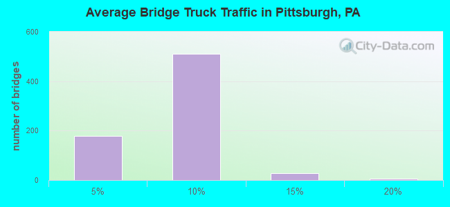
- 8,123,148Total average daily traffic
- 545,684Total average daily truck traffic
- National Bridge Inventory (NBI) Registered Bridges for Pittsburgh
- No street view available for this location
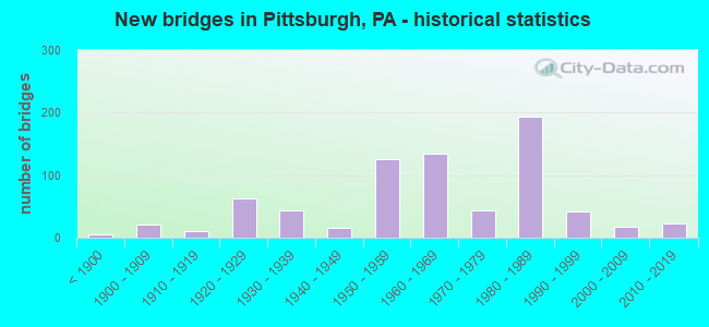
- New bridges - historical statistics
- 5Before 1900
- 211900-1909
- 101910-1919
- 631920-1929
- 431930-1939
- 161940-1949
- 1261950-1959
- 1341960-1969
- 441970-1979
- 1941980-1989
- 421990-1999
- 172000-2009
- 232010-2019
- 12020-2022
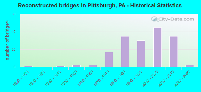
- Reconstructed bridges - Historical Statistics
- 11920-1929
- 01930-1939
- 11940-1949
- 21950-1959
- 21960-1969
- 171970-1979
- 351980-1989
- 301990-1999
- 452000-2009
- 352010-2019
- 22020-2022

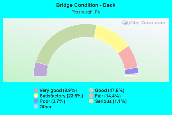
- Bridge Condition - Deck
- 8.9%Very good
- 47.6%Good
- 23.6%Satisfactory
- 14.4%Fair
- 3.7%Poor
- 1.1%Serious
- 0.7%Critical
- 0.4%Imminent failure
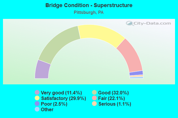
- Bridge Condition - Superstructure
- 11.4%Very good
- 32.0%Good
- 29.9%Satisfactory
- 22.1%Fair
- 2.5%Poor
- 1.1%Serious
- 1.1%Critical
- 0.7%Imminent failure
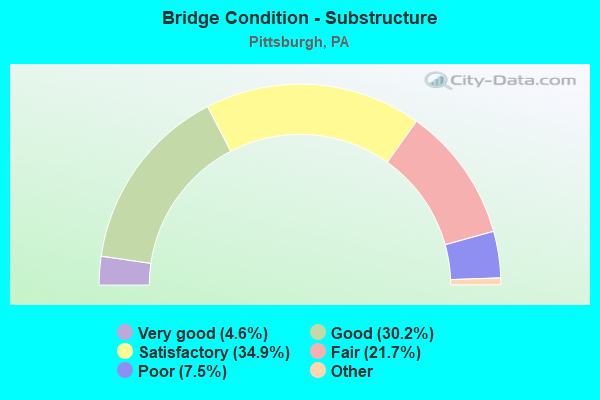
- Bridge Condition - Substructure
- 4.6%Excellent
- 30.2%Very good
- 34.9%Good
- 21.7%Satisfactory
- 7.5%Fair
- 1.1%Poor
- 0.7%Serious
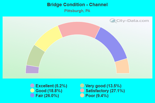
- Bridge Condition - Channel
- 5.2%Excellent
- 13.5%Very good
- 18.8%Good
- 27.1%Satisfactory
- 26.0%Fair
- 9.4%Poor
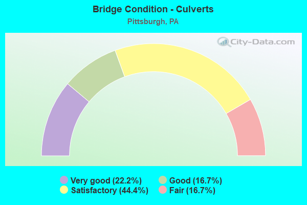
- Bridge Condition - Culverts
- 22.2%Very good
- 16.7%Good
- 44.4%Satisfactory
- 16.7%Fair
Find on map >> Show street view
Structure Number: 2918, Location: MCKNIGHT INTERCHANGE RAMP (Lat: 40.500833, Lng: -80.012050), Route carried "under" structure: US 19T, Year Built: 1986, Structure Length: 0. m, Average Daily Traffic: 4,131 (year 2022), Truck Traffic: 8%, Features Intersected: SR 4003-EVERGREEN RD., Facility Carried by Structure: RAMP J RD
Minimum Vertical Clearance: 30+ m (98+ ft), Kilometerpoint: 0.919, Lanes on structure: 1, Lanes under structure: 1, Material/Design: Steel continuous, Design/Construction: Stringer/Multi-beam, Length of Maximum Span: 52.7m (172.9ft)
Find on map >> Show street view
Structure Number: 2918, Location: MCKNIGHT INTERCHANGE RAMP (Lat: 40.500833, Lng: -80.012050), Route carried "under" structure: State highway , Year Built: 1986, Structure Length: 0. m, Average Daily Traffic: 3,911 (year 2022), Truck Traffic: 2%, Features Intersected: SR 4003-EVERGREEN RD., Facility Carried by Structure: RAMP J RD
Minimum Vertical Clearance: 6.68m (21.92ft), Kilometerpoint: 6.605, Lanes on structure: 1, Lanes under structure: 4, Material/Design: Steel continuous, Design/Construction: Stringer/Multi-beam, Length of Maximum Span: 52.7m (172.9ft)
Find on map >> Show street view
Structure Number: 2918, Location: MCKNIGHT INTERCHANGE RAMP (Lat: 40.500833, Lng: -80.012050), Route carried "under" structure: US 19T, Year Built: 1986, Structure Length: 0. m, Average Daily Traffic: 8,079 (year 2022), Truck Traffic: 5%, Features Intersected: SR 4003-EVERGREEN RD., Facility Carried by Structure: RAMP J RD
Minimum Vertical Clearance: 9.47m (31.07ft), Kilometerpoint: 0.916, Lanes on structure: 1, Lanes under structure: 4, Material/Design: Steel continuous, Design/Construction: Stringer/Multi-beam, Length of Maximum Span: 52.7m (172.9ft)
Find on map >> Show street view
Structure Number: 2919, Location: HOV MCKNIGHT INTERCHANGE (Lat: 40.500000, Lng: -80.000000), Route carried "under" structure: US 19T, Year Built: 1986, Structure Length: 0. m, Average Daily Traffic: 16,461 (year 2022), Truck Traffic: 2%, Features Intersected: MCKNIGHT/EVERGREEN RD, Facility Carried by Structure: RAMP S
Minimum Vertical Clearance: 5.28m (17.32ft), Kilometerpoint: 0.919, Lanes on structure: 1, Lanes under structure: 6, Material/Design: Steel continuous, Design/Construction: Stringer/Multi-beam, Length of Maximum Span: 46.9m (153.9ft)
Find on map >> Show street view
Structure Number: 2919, Location: HOV MCKNIGHT INTERCHANGE (Lat: 40.500000, Lng: -80.000000), Route carried "under" structure: State highway , Year Built: 1986, Structure Length: 0. m, Average Daily Traffic: 2,426 (year 2022), Truck Traffic: 4%, Features Intersected: MCKNIGHT/EVERGREEN RD, Facility Carried by Structure: RAMP S
Minimum Vertical Clearance: 11.58m (37.99ft), Kilometerpoint: 6.547, Lanes on structure: 1, Lanes under structure: 6, Material/Design: Steel continuous, Design/Construction: Stringer/Multi-beam, Length of Maximum Span: 46.9m (153.9ft)
Find on map >> Show street view
Structure Number: 2919, Location: HOV MCKNIGHT INTERCHANGE (Lat: 40.500000, Lng: -80.000000), Route carried "under" structure: US 19T, Year Built: 1986, Structure Length: 0. m, Average Daily Traffic: 21,149 (year 2022), Truck Traffic: 2%, Features Intersected: MCKNIGHT/EVERGREEN RD, Facility Carried by Structure: RAMP S
Minimum Vertical Clearance: 4.98m (16.34ft), Kilometerpoint: 0.916, Lanes on structure: 1, Lanes under structure: 6, Material/Design: Steel continuous, Design/Construction: Stringer/Multi-beam, Length of Maximum Span: 46.9m (153.9ft)
Find on map >> Show street view
Structure Number: 2919, Location: HOV MCKNIGHT INTERCHANGE (Lat: 40.500000, Lng: -80.000000), Route carried "under" structure: State highway , Year Built: 1986, Structure Length: 0. m, Average Daily Traffic: 3,911 (year 2022), Truck Traffic: 2%, Features Intersected: MCKNIGHT/EVERGREEN RD, Facility Carried by Structure: RAMP S
Minimum Vertical Clearance: 11.58m (37.99ft), Kilometerpoint: 6.605, Lanes on structure: 1, Lanes under structure: 6, Material/Design: Steel continuous, Design/Construction: Stringer/Multi-beam, Length of Maximum Span: 46.9m (153.9ft)
Find on map >> Show street view
Structure Number: 2924, Location: NEAR HEINZ FIELD (Lat: 40.450000, Lng: -80.008333), Route carried "under" structure: City street , Year Built: 1986, Structure Length: 0. m, Average Daily Traffic: 1 (year 2004), Truck Traffic: 1%, Features Intersected: 1021 RP.B & SCOTLAND AVE, Facility Carried by Structure: RAMP W
Minimum Vertical Clearance: 8.23m (27.00ft), Kilometerpoint: 0.000, Lanes on structure: 1, Lanes under structure: 2, Material/Design: Steel continuous, Design/Construction: Box Beam or Girders - Single/Spread, Length of Maximum Span: 33.5m (109.9ft)
Find on map >> Show street view
Structure Number: 2924, Location: NEAR HEINZ FIELD (Lat: 40.450000, Lng: -80.008333), Route carried "under" structure: Ramp State highway , Year Built: 1986, Structure Length: 0. m, Average Daily Traffic: 2,278 (year 2021), Truck Traffic: 7%, Features Intersected: 1021 RP.B & SCOTLAND AVE, Facility Carried by Structure: RAMP W
Minimum Vertical Clearance: 10.54m (34.58ft), Kilometerpoint: 0.000, Lanes on structure: 1, Lanes under structure: 1, Material/Design: Steel continuous, Design/Construction: Box Beam or Girders - Single/Spread, Length of Maximum Span: 33.5m (109.9ft)
Find on map >> Show street view
Structure Number: 2928, Location: HEINZ FIELD/SR 65 NB (Lat: 40.448631, Lng: -80.009092), Route carried "under" structure: City street , Year Built: 1986, Structure Length: 0. m, Average Daily Traffic: 1 (year 2004), Truck Traffic: 1%, Features Intersected: 1021 RP.B & CITY STREETS, Facility Carried by Structure: RAMP V
Minimum Vertical Clearance: 5.89m (19.32ft), Kilometerpoint: 0.000, Lanes on structure: 1, Lanes under structure: 5, Material/Design: Steel continuous, Design/Construction: Stringer/Multi-beam, Length of Maximum Span: 43.3m (142.1ft)
Find on map >> Show street view
Structure Number: 2928, Location: HEINZ FIELD/SR 65 NB (Lat: 40.448631, Lng: -80.009092), Route carried "under" structure: City street , Year Built: 1986, Structure Length: 0. m, Average Daily Traffic: 1 (year 2004), Truck Traffic: 1%, Features Intersected: 1021 RP.B & CITY STREETS, Facility Carried by Structure: RAMP V
Minimum Vertical Clearance: 11.48m (37.66ft), Kilometerpoint: 0.000, Lanes on structure: 1, Lanes under structure: 5, Material/Design: Steel continuous, Design/Construction: Stringer/Multi-beam, Length of Maximum Span: 43.3m (142.1ft)
Find on map >> Show street view
Structure Number: 2928, Location: HEINZ FIELD/SR 65 NB (Lat: 40.448631, Lng: -80.009092), Route carried "under" structure: Ramp State highway , Year Built: 1986, Structure Length: 0. m, Average Daily Traffic: 2,278 (year 2021), Truck Traffic: 7%, Features Intersected: 1021 RP.B & CITY STREETS, Facility Carried by Structure: RAMP V
Minimum Vertical Clearance: 5.74m (18.83ft), Kilometerpoint: 0.000, Lanes on structure: 1, Lanes under structure: 5, Material/Design: Steel continuous, Design/Construction: Stringer/Multi-beam, Length of Maximum Span: 43.3m (142.1ft)
Find on map >> Show street view
Structure Number: 2929, Location: Veterans Bridge (Lat: 40.466667, Lng: -80.016667), Route carried "under" structure: Ramp State highway , Year Built: 1988, Structure Length: 0. m, Average Daily Traffic: 2,107 (year 2021), Truck Traffic: 7%, Features Intersected: N & S ,RAMP N, Facility Carried by Structure: RAMP H
Minimum Vertical Clearance: 12.52m (41.08ft), Kilometerpoint: 0.000, Lanes on structure: 1, Lanes under structure: 1, Material/Design: Steel continuous, Design/Construction: Stringer/Multi-beam, Length of Maximum Span: 41.1m (134.8ft)
Find on map >> Show street view
Structure Number: 293, Location: OVER ANDERSON ST. (Lat: 40.466667, Lng: -80.016667), Route carried "under" structure: City street , Year Built: 1986, Structure Length: 0. m, Average Daily Traffic: 1,500 (year 2004), Truck Traffic: 4%, Features Intersected: ANDERSON ST., Facility Carried by Structure: RAMP A
Minimum Vertical Clearance: 4.82m (15.81ft), Kilometerpoint: 0.000, Lanes on structure: 1, Lanes under structure: 3, Material/Design: Prestressed concrete continuous, Design/Construction: Stringer/Multi-beam, Length of Maximum Span: 29.6m (97.1ft)
Find on map >> Show street view
Structure Number: 2932, Location: Veterans Bridge (Lat: 40.466667, Lng: -80.016667), Route carried "under" structure: State highway 28, Year Built: 1988, Structure Length: 0. m, Average Daily Traffic: 11,707 (year 2022), Truck Traffic: 3%, Features Intersected: MADISON,NORFOLKSOUTH RR, Facility Carried by Structure: RAMP G
Minimum Vertical Clearance: 14.15m (46.42ft), Kilometerpoint: 0.000, Lanes on structure: 1, Lanes under structure: 3, Material/Design: Steel, Design/Construction: Stringer/Multi-beam, Length of Maximum Span: 37.8m (124.0ft)
Find on map >> Show street view
Structure Number: 2932, Location: Veterans Bridge (Lat: 40.466667, Lng: -80.016667), Route carried "under" structure: State highway 28, Year Built: 1988, Structure Length: 0. m, Average Daily Traffic: 7,220 (year 2022), Truck Traffic: 3%, Features Intersected: MADISON,NORFOLKSOUTH RR, Facility Carried by Structure: RAMP G
Minimum Vertical Clearance: 10.44m (34.25ft), Kilometerpoint: 0.000, Lanes on structure: 1, Lanes under structure: 2, Material/Design: Steel, Design/Construction: Stringer/Multi-beam, Length of Maximum Span: 37.8m (124.0ft)
Find on map >> Show street view
Structure Number: 2932, Location: Veterans Bridge (Lat: 40.466667, Lng: -80.016667), Route carried "under" structure: State highway , Year Built: 1988, Structure Length: 0. m, Average Daily Traffic: 4,058 (year 2021), Truck Traffic: 7%, Features Intersected: MADISON,NORFOLKSOUTH RR, Facility Carried by Structure: RAMP G
Minimum Vertical Clearance: 4.50m (14.76ft), Kilometerpoint: 0.000, Lanes on structure: 1, Lanes under structure: 2, Material/Design: Steel, Design/Construction: Stringer/Multi-beam, Length of Maximum Span: 37.8m (124.0ft)
Find on map >> Show street view
Structure Number: 2934, Location: NEAR HEINZ PLANT (Lat: 40.466667, Lng: -80.016667), Route carried "under" structure: State highway 28, Year Built: 1988, Structure Length: 0. m, Average Daily Traffic: 7,258 (year 2022), Truck Traffic: 4%, Features Intersected: SR 0028 NB-SB,RAMP H, Facility Carried by Structure: RAMP J
Minimum Vertical Clearance: 4.82m (15.81ft), Kilometerpoint: 0.571, Lanes on structure: 1, Lanes under structure: 5, Material/Design: Steel continuous, Design/Construction: Stringer/Multi-beam, Length of Maximum Span: 26.2m (86.0ft)
Find on map >> Show street view
Structure Number: 2934, Location: NEAR HEINZ PLANT (Lat: 40.466667, Lng: -80.016667), Route carried "under" structure: State highway 28, Year Built: 1988, Structure Length: 0. m, Average Daily Traffic: 11,707 (year 2022), Truck Traffic: 3%, Features Intersected: SR 0028 NB-SB,RAMP H, Facility Carried by Structure: RAMP J
Minimum Vertical Clearance: 4.82m (15.81ft), Kilometerpoint: 0.604, Lanes on structure: 1, Lanes under structure: 5, Material/Design: Steel continuous, Design/Construction: Stringer/Multi-beam, Length of Maximum Span: 26.2m (86.0ft)
Find on map >> Show street view
Structure Number: 40674, Location: 0.1 MILE S.LIBERTY TUNNEL (Lat: 40.414053, Lng: -80.009647), Route carried "under" structure: Alternate State highway , Year Built: 1999, Structure Length: 0. m, Average Daily Traffic: 19,458 (year 2020), Truck Traffic: 3%, Features Intersected: W LIBERTY AVE. SR 3069, Facility Carried by Structure: SAW MILL RUN BLVD
Minimum Vertical Clearance: 4.88m (16.01ft), Kilometerpoint: 5.961, Lanes on structure: 5, Lanes under structure: 8, Material/Design: Steel, Design/Construction: Stringer/Multi-beam, Length of Maximum Span: 55.2m (181.1ft)
Find on map >> Show street view
Structure Number: 40674, Location: 0.1 MILE S.LIBERTY TUNNEL (Lat: 40.414053, Lng: -80.009647), Route carried "under" structure: Ramp State highway , Year Built: 1999, Structure Length: 0. m, Average Daily Traffic: 6,543 (year 2022), Truck Traffic: 10%, Features Intersected: W LIBERTY AVE. SR 3069, Facility Carried by Structure: SAW MILL RUN BLVD
Minimum Vertical Clearance: 6.61m (21.69ft), Kilometerpoint: 0.000, Lanes on structure: 5, Lanes under structure: 8, Material/Design: Steel, Design/Construction: Stringer/Multi-beam, Length of Maximum Span: 55.2m (181.1ft)
Find on map >> Show street view
Structure Number: 40674, Location: 0.1 MILE S.LIBERTY TUNNEL (Lat: 40.414053, Lng: -80.009647), Route carried "under" structure: Alternate State highway , Year Built: 1999, Structure Length: 0. m, Average Daily Traffic: 13,823 (year 2020), Truck Traffic: 4%, Features Intersected: W LIBERTY AVE. SR 3069, Facility Carried by Structure: SAW MILL RUN BLVD
Minimum Vertical Clearance: 4.88m (16.01ft), Kilometerpoint: 5.972, Lanes on structure: 5, Lanes under structure: 8, Material/Design: Steel, Design/Construction: Stringer/Multi-beam, Length of Maximum Span: 55.2m (181.1ft)
Find on map >> Show street view
Structure Number: 40675, Location: .1 MILE S. LIBERTY TUNNEL (Lat: 40.419444, Lng: -80.000000), Route carried "under" structure: Ramp State highway , Year Built: 1999, Structure Length: 0. m, Average Daily Traffic: 6,543 (year 2022), Truck Traffic: 10%, Features Intersected: RAMP C, Facility Carried by Structure: RAMP E SR 8151
Minimum Vertical Clearance: 5.54m (18.18ft), Kilometerpoint: 0.000, Lanes on structure: 1, Lanes under structure: 3, Material/Design: Steel, Design/Construction: Stringer/Multi-beam, Length of Maximum Span: 30.5m (100.1ft)
Find on map >> Show street view
Structure Number: 40852, Location: SR 65 Marshall Ave. Inter (Lat: 40.458333, Lng: -80.033333), Route carried "under" structure: State highway , Year Built: 1972, Structure Length: 0. m, Average Daily Traffic: 6,000 (year 2002), Truck Traffic: 7%, Features Intersected: CHATEAU ST. N&S RR, Facility Carried by Structure: RAMP D to SR 65 SB
Minimum Vertical Clearance: 8.53m (27.99ft), Kilometerpoint: 0.000, Lanes on structure: 2, Lanes under structure: 2, Material/Design: Steel continuous, Design/Construction: Girder and Floorbeam System, Length of Maximum Span: 36.6m (120.1ft)
Find on map >> Show street view
Structure Number: 42749, Location: Fort Duquesne Bridge (Lat: 40.466667, Lng: -80.016667), Route carried "under" structure: City street , Year Built: 1985, Structure Length: 0. m, Average Daily Traffic: 1 (year 2005), Truck Traffic: 1%, Features Intersected: VARIOUS CITY STREETS, Facility Carried by Structure: SR 0279 SB
Minimum Vertical Clearance: 4.82m (15.81ft), Kilometerpoint: 0.000, Lanes on structure: 2, Lanes under structure: 4, Material/Design: Steel continuous, Design/Construction: Box Beam or Girders - Single/Spread, Length of Maximum Span: 42.7m (140.1ft)
Find on map >> Show street view
Structure Number: 42749, Location: Fort Duquesne Bridge (Lat: 40.466667, Lng: -80.016667), Route carried "under" structure: City street , Year Built: 1985, Structure Length: 0. m, Average Daily Traffic: 1 (year 2005), Truck Traffic: 1%, Features Intersected: VARIOUS CITY STREETS, Facility Carried by Structure: SR 0279 SB
Minimum Vertical Clearance: 7.98m (26.18ft), Kilometerpoint: 0.000, Lanes on structure: 2, Lanes under structure: 4, Material/Design: Steel continuous, Design/Construction: Box Beam or Girders - Single/Spread, Length of Maximum Span: 42.7m (140.1ft)
Find on map >> Show street view
Structure Number: 42749, Location: Fort Duquesne Bridge (Lat: 40.466667, Lng: -80.016667), Route carried "under" structure: City street , Year Built: 1985, Structure Length: 0. m, Average Daily Traffic: 1 (year 2005), Truck Traffic: 1%, Features Intersected: VARIOUS CITY STREETS, Facility Carried by Structure: SR 0279 SB
Minimum Vertical Clearance: 4.80m (15.75ft), Kilometerpoint: 0.000, Lanes on structure: 2, Lanes under structure: 2, Material/Design: Steel continuous, Design/Construction: Box Beam or Girders - Single/Spread, Length of Maximum Span: 42.7m (140.1ft)
Find on map >> Show street view
Structure Number: 42749, Location: Fort Duquesne Bridge (Lat: 40.466667, Lng: -80.016667), Route carried "under" structure: City street , Year Built: 1985, Structure Length: 0. m, Average Daily Traffic: 1 (year 2005), Truck Traffic: 1%, Features Intersected: VARIOUS CITY STREETS, Facility Carried by Structure: SR 0279 SB
Minimum Vertical Clearance: 4.85m (15.91ft), Kilometerpoint: 0.000, Lanes on structure: 2, Lanes under structure: 3, Material/Design: Steel continuous, Design/Construction: Box Beam or Girders - Single/Spread, Length of Maximum Span: 42.7m (140.1ft)
Find on map >> Show street view
Structure Number: 4511, Location: NORTH SIDE (Lat: 40.500000, Lng: -80.000000), Route carried "under" structure: Interstate 279, Year Built: 2008, Structure Length: 0. m, Average Daily Traffic: 13,726 (year 2022), Truck Traffic: 8%, Features Intersected: SR 279 AND MADISON AVE
Minimum Vertical Clearance: 5.12m (16.80ft), Kilometerpoint: 1.754, Lanes on structure: 1, Lanes under structure: 2, Material/Design: Steel continuous, Design/Construction: Stringer/Multi-beam, Length of Maximum Span: 50.9m (167.0ft)
Find on map >> Show street view
Structure Number: 4511, Location: NORTH SIDE (Lat: 40.500000, Lng: -80.000000), Route carried "under" structure: Interstate 279, Year Built: 2008, Structure Length: 0. m, Average Daily Traffic: 14,673 (year 2022), Truck Traffic: 8%, Features Intersected: SR 279 AND MADISON AVE
Minimum Vertical Clearance: 5.12m (16.80ft), Kilometerpoint: 1.719, Lanes on structure: 1, Lanes under structure: 2, Material/Design: Steel continuous, Design/Construction: Stringer/Multi-beam, Length of Maximum Span: 50.9m (167.0ft)
Find on map >> Show street view
Structure Number: 4511, Location: NORTH SIDE (Lat: 40.500000, Lng: -80.000000), Route carried "under" structure: Interstate 279, Year Built: 2008, Structure Length: 0. m, Average Daily Traffic: 586 (year 2021), Truck Traffic: 4%, Features Intersected: SR 279 AND MADISON AVE
Minimum Vertical Clearance: 5.67m (18.60ft), Kilometerpoint: 1.006, Lanes on structure: 1, Lanes under structure: 1, Material/Design: Steel continuous, Design/Construction: Stringer/Multi-beam, Length of Maximum Span: 50.9m (167.0ft)
Find on map >> Show street view
Structure Number: 45203, Location: 1 MILE E OF BIRMINGHAM BR (Lat: 40.435928, Lng: -79.964831), Route carried "under" structure: State highway , Year Built: 2008, Structure Length: 0. m, Average Daily Traffic: 21,214 (year 2022), Truck Traffic: 6%, Features Intersected: FORBES AV, MAURICE ST, Facility Carried by Structure: BL OF THE ALLIES
Minimum Vertical Clearance: 5.64m (18.50ft), Kilometerpoint: 0.000, Lanes on structure: 2, Lanes under structure: 3, Material/Design: Steel continuous, Design/Construction: Stringer/Multi-beam, Length of Maximum Span: 50.9m (167.0ft)
Find on map >> Show street view
Structure Number: 45203, Location: 1 MILE E OF BIRMINGHAM BR (Lat: 40.435928, Lng: -79.964831), Route carried "under" structure: City street , Year Built: 2008, Structure Length: 0. m, Features Intersected: FORBES AV, MAURICE ST, Facility Carried by Structure: BL OF THE ALLIES
Minimum Vertical Clearance: 6.10m (20.01ft), Kilometerpoint: 0.000, Lanes on structure: 2, Lanes under structure: 2, Material/Design: Steel continuous, Design/Construction: Stringer/Multi-beam, Length of Maximum Span: 50.9m (167.0ft)
Find on map >> Show street view
Structure Number: 4526, Location: Highland Park Bridge (Lat: 40.486239, Lng: -79.913333), Route carried "under" structure: State highway 8, Year Built: 1940, Structure Length: 0. m, Average Daily Traffic: 10,744 (year 2020), Truck Traffic: 7%, Features Intersected: SR 0008, Facility Carried by Structure: HIGHLAND PARK APPR
Minimum Vertical Clearance: 4.72m (15.49ft), Kilometerpoint: 8.258, Lanes on structure: 2, Lanes under structure: 2, Material/Design: Steel, Design/Construction: Stringer/Multi-beam, Length of Maximum Span: 19.5m (64.0ft)
Find on map >> Show street view
Structure Number: 45848, Location: SR 19 OVER S.MAIN ST (Lat: 40.740000, Lng: -80.053889), Route carried "under" structure: State highway 60, Year Built: 2010, Structure Length: 0. m, Average Daily Traffic: 13,241 (year 2022), Truck Traffic: 3%, Features Intersected: SR 60 @ SR 19 INTER, Facility Carried by Structure: SR 19
Minimum Vertical Clearance: 5.22m (17.13ft), Kilometerpoint: 0.000, Lanes on structure: 2, Lanes under structure: 2, Material/Design: Steel, Design/Construction: Stringer/Multi-beam, Length of Maximum Span: 57.3m (188.0ft)
Find on map >> Show street view
Structure Number: 45849, Location: WEST END (Lat: 40.442733, Lng: -80.030042), Route carried "under" structure: State highway 60, Year Built: 2010, Structure Length: 0. m, Average Daily Traffic: 13,241 (year 2022), Truck Traffic: 3%, Features Intersected: SOUTH MAIN STREET, Facility Carried by Structure: SR 0051 SB
Minimum Vertical Clearance: 5.64m (18.50ft), Kilometerpoint: 0.000, Lanes on structure: 2, Lanes under structure: 2, Material/Design: Steel, Design/Construction: Stringer/Multi-beam, Length of Maximum Span: 54.9m (180.1ft)
Find on map >> Show street view
Structure Number: 47751, Location: 301143 OV 10th St. Ext. (Lat: 40.443439, Lng: -80.006253), Route carried "under" structure: Ramp State highway , Year Built: 2012, Structure Length: 0. m, Average Daily Traffic: 8,791 (year 2022), Truck Traffic: 6%, Features Intersected: Tenth St. Bypass, Facility Carried by Structure: Fancourt Street
Minimum Vertical Clearance: 4.69m (15.39ft), Kilometerpoint: 0.000, Lanes on structure: 1, Lanes under structure: 2, Material/Design: Steel, Design/Construction: Stringer/Multi-beam, Length of Maximum Span: 23.8m (78.1ft)
Find on map >> Show street view
Structure Number: 54496, Location: Greenfield Av ovr I-376 (Lat: 40.428575, Lng: -79.937878), Route carried "under" structure: Alternate Interstate 376, Year Built: 2017, Structure Length: 0. m, Average Daily Traffic: 54,114 (year 2022), Truck Traffic: 6%, Features Intersected: I-376 Parkway East, Facility Carried by Structure: Greenfield Ave
Minimum Vertical Clearance: 23.84m (78.22ft), Kilometerpoint: 39.929, Lanes on structure: 3, Lanes under structure: 3, Material/Design: Steel continuous, Design/Construction: Arch - Deck, Length of Maximum Span: 99.4m (326.1ft)
Find on map >> Show street view
Structure Number: 54496, Location: Greenfield Av ovr I-376 (Lat: 40.428575, Lng: -79.937878), Route carried "under" structure: Interstate 376, Year Built: 2017, Structure Length: 0. m, Average Daily Traffic: 43,330 (year 2022), Truck Traffic: 6%, Features Intersected: I-376 Parkway East, Facility Carried by Structure: Greenfield Ave
Minimum Vertical Clearance: 18.59m (60.99ft), Kilometerpoint: 39.884, Lanes on structure: 3, Lanes under structure: 3, Material/Design: Steel continuous, Design/Construction: Arch - Deck, Length of Maximum Span: 99.4m (326.1ft)
Find on map >> Show street view
Structure Number: 54732, Location: 1/4 MI NW OF I-376 (Lat: 40.433333, Lng: -80.028889), Route carried "under" structure: US 19, Year Built: 2019, Structure Length: 0. m, Average Daily Traffic: 16,674 (year 2022), Truck Traffic: 6%, Features Intersected: SR 19, Facility Carried by Structure: SHALER STREET
Minimum Vertical Clearance: 5.21m (17.09ft), Kilometerpoint: 14.849, Lanes on structure: 2, Lanes under structure: 3, Material/Design: Steel continuous, Design/Construction: Stringer/Multi-beam, Length of Maximum Span: 21.3m (69.9ft)
Find on map >> Show street view
Structure Number: 54732, Location: 1/4 MI NW OF I-376 (Lat: 40.433333, Lng: -80.028889), Route carried "under" structure: US 19, Year Built: 2019, Structure Length: 0. m, Average Daily Traffic: 10,726 (year 2022), Truck Traffic: 10%, Features Intersected: SR 19, Facility Carried by Structure: SHALER STREET
Minimum Vertical Clearance: 5.73m (18.80ft), Kilometerpoint: 15.080, Lanes on structure: 2, Lanes under structure: 2, Material/Design: Steel continuous, Design/Construction: Stringer/Multi-beam, Length of Maximum Span: 21.3m (69.9ft)
Find on map >> Show street view
Structure Number: 68228, Location: Fort Pitt Bridge (Lat: 40.439306, Lng: -80.010278), Route carried "under" structure: Interstate 376, Year Built: 1953, Structure Length: 0. m, Average Daily Traffic: 52,977 (year 2021), Truck Traffic: 7%, Features Intersected: MON RIVER & WARF, 376 WB
Minimum Vertical Clearance: 4.37m (14.34ft), Kilometerpoint: 32.975, Lanes on structure: 2, Lanes under structure: 2, Material/Design: Prestressed concrete continuous, Design/Construction: Stringer/Multi-beam, Length of Maximum Span: 16.5m (54.1ft)