Bridge Statistics for Pittsburgh, Pennsylvania (PA)
Condition, Traffic, Stress, Structural Evaluation, Project Costs
- National Bridge Inventory (NBI) Statistics
- 739Number of bridges
- 14,564ft / 4,439mTotal length
- $433,022,000Total costs
- 8,123,148Total average daily traffic
- 545,684Total average daily truck traffic
- National Bridge Inventory (NBI) Registered Bridges for Pittsburgh
- No street view available for this location
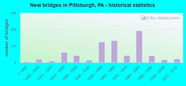
- New bridges - historical statistics
- 5Before 1900
- 211900-1909
- 101910-1919
- 631920-1929
- 431930-1939
- 161940-1949
- 1261950-1959
- 1341960-1969
- 441970-1979
- 1941980-1989
- 421990-1999
- 172000-2009
- 232010-2019
- 12020-2022
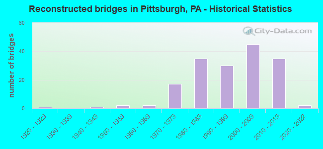
- Reconstructed bridges - Historical Statistics
- 11920-1929
- 01930-1939
- 11940-1949
- 21950-1959
- 21960-1969
- 171970-1979
- 351980-1989
- 301990-1999
- 452000-2009
- 352010-2019
- 22020-2022

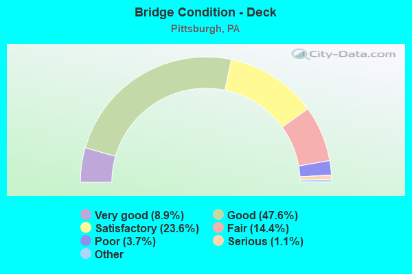
- Bridge Condition - Deck
- 8.9%Very good
- 47.6%Good
- 23.6%Satisfactory
- 14.4%Fair
- 3.7%Poor
- 1.1%Serious
- 0.7%Critical
- 0.4%Imminent failure
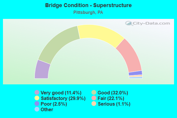
- Bridge Condition - Superstructure
- 11.4%Very good
- 32.0%Good
- 29.9%Satisfactory
- 22.1%Fair
- 2.5%Poor
- 1.1%Serious
- 1.1%Critical
- 0.7%Imminent failure
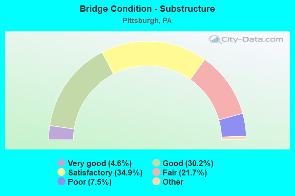
- Bridge Condition - Substructure
- 4.6%Excellent
- 30.2%Very good
- 34.9%Good
- 21.7%Satisfactory
- 7.5%Fair
- 1.1%Poor
- 0.7%Serious
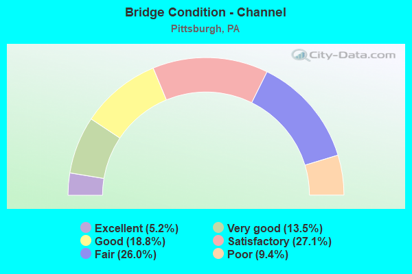
- Bridge Condition - Channel
- 5.2%Excellent
- 13.5%Very good
- 18.8%Good
- 27.1%Satisfactory
- 26.0%Fair
- 9.4%Poor
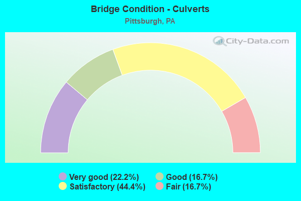
- Bridge Condition - Culverts
- 22.2%Very good
- 16.7%Good
- 44.4%Satisfactory
- 16.7%Fair
Find on map >> Show street view
Structure Number: 2732, Location: SR0579 SB TO LIBERTY BR (Lat: 40.437806, Lng: -79.994378), Route carried "under" structure: State highway , Year Built: 1962, Structure Length: 0. m, Average Daily Traffic: 2,461 (year 2020), Truck Traffic: 2%, Features Intersected: CROSSTOWN BLVD, Facility Carried by Structure: RAMP J
Minimum Vertical Clearance: 4.80m (15.75ft), Kilometerpoint: 8.695, Lanes on structure: 1, Lanes under structure: 2, Material/Design: Steel continuous, Design/Construction: Stringer/Multi-beam, Length of Maximum Span: 38.1m (125.0ft)
Find on map >> Show street view
Structure Number: 2732, Location: SR0579 SB TO LIBERTY BR (Lat: 40.437806, Lng: -79.994378), Route carried "under" structure: City street , Year Built: 1962, Structure Length: 0. m, Average Daily Traffic: 1 (year 2014), Truck Traffic: 1%, Features Intersected: CROSSTOWN BLVD, Facility Carried by Structure: RAMP J
Minimum Vertical Clearance: 5.09m (16.70ft), Kilometerpoint: 0.000, Lanes on structure: 1, Lanes under structure: 4, Material/Design: Steel continuous, Design/Construction: Stringer/Multi-beam, Length of Maximum Span: 38.1m (125.0ft)
Find on map >> Show street view
Structure Number: 2732, Location: SR0579 SB TO LIBERTY BR (Lat: 40.437806, Lng: -79.994378), Route carried "under" structure: City street , Year Built: 1962, Structure Length: 0. m, Average Daily Traffic: 1 (year 2014), Truck Traffic: 1%, Features Intersected: CROSSTOWN BLVD, Facility Carried by Structure: RAMP J
Minimum Vertical Clearance: 6.85m (22.47ft), Kilometerpoint: 0.000, Lanes on structure: 1, Lanes under structure: 3, Material/Design: Steel continuous, Design/Construction: Stringer/Multi-beam, Length of Maximum Span: 38.1m (125.0ft)
Find on map >> Show street view
Structure Number: 2733, Location: RP. FROM BLVD.TO SR579 NB (Lat: 40.433333, Lng: -79.988333), Route carried "under" structure: State highway , Year Built: 1962, Structure Length: 0. m, Average Daily Traffic: 1,773 (year 2020), Truck Traffic: 2%, Features Intersected: CROSSTOWN BLVD, Facility Carried by Structure: RAMP K
Minimum Vertical Clearance: 30+ m (98+ ft), Kilometerpoint: 8.718, Lanes on structure: 1, Lanes under structure: 2, Material/Design: Steel continuous, Design/Construction: Stringer/Multi-beam, Length of Maximum Span: 38.1m (125.0ft)
Find on map >> Show street view
Structure Number: 2733, Location: RP. FROM BLVD.TO SR579 NB (Lat: 40.433333, Lng: -79.988333), Route carried "under" structure: Ramp State highway , Year Built: 1962, Structure Length: 0. m, Average Daily Traffic: 10,555 (year 2021), Truck Traffic: 7%, Features Intersected: CROSSTOWN BLVD, Facility Carried by Structure: RAMP K
Minimum Vertical Clearance: 4.91m (16.11ft), Kilometerpoint: 0.000, Lanes on structure: 1, Lanes under structure: 1, Material/Design: Steel continuous, Design/Construction: Stringer/Multi-beam, Length of Maximum Span: 38.1m (125.0ft)
Find on map >> Show street view
Structure Number: 2733, Location: RP. FROM BLVD.TO SR579 NB (Lat: 40.433333, Lng: -79.988333), Route carried "under" structure: Ramp State highway , Year Built: 1962, Structure Length: 0. m, Average Daily Traffic: 4,979 (year 2021), Truck Traffic: 7%, Features Intersected: CROSSTOWN BLVD, Facility Carried by Structure: RAMP K
Minimum Vertical Clearance: 4.95m (16.24ft), Kilometerpoint: 0.000, Lanes on structure: 1, Lanes under structure: 1, Material/Design: Steel continuous, Design/Construction: Stringer/Multi-beam, Length of Maximum Span: 38.1m (125.0ft)
Find on map >> Show street view
Structure Number: 2733, Location: RP. FROM BLVD.TO SR579 NB (Lat: 40.433333, Lng: -79.988333), Route carried "under" structure: State highway , Year Built: 1962, Structure Length: 0. m, Average Daily Traffic: 2,461 (year 2020), Truck Traffic: 2%, Features Intersected: CROSSTOWN BLVD, Facility Carried by Structure: RAMP K
Minimum Vertical Clearance: 6.47m (21.23ft), Kilometerpoint: 8.695, Lanes on structure: 1, Lanes under structure: 2, Material/Design: Steel continuous, Design/Construction: Stringer/Multi-beam, Length of Maximum Span: 38.1m (125.0ft)
Find on map >> Show street view
Structure Number: 2733, Location: RP. FROM BLVD.TO SR579 NB (Lat: 40.433333, Lng: -79.988333), Route carried "under" structure: City street , Year Built: 1962, Structure Length: 0. m, Average Daily Traffic: 100 (year 2004), Truck Traffic: 1%, Features Intersected: CROSSTOWN BLVD, Facility Carried by Structure: RAMP K
Minimum Vertical Clearance: 7.01m (23.00ft), Kilometerpoint: 0.000, Lanes on structure: 1, Lanes under structure: 3, Material/Design: Steel continuous, Design/Construction: Stringer/Multi-beam, Length of Maximum Span: 38.1m (125.0ft)
Find on map >> Show street view
Structure Number: 2739, Location: RP.FROM LIB.BR.TO SR579NB (Lat: 40.433333, Lng: -79.988333), Route carried "under" structure: City street , Year Built: 1962, Structure Length: 0. m, Average Daily Traffic: 1 (year 2004), Truck Traffic: 1%, Features Intersected: FORBES AVE, DIAMOND ST., Facility Carried by Structure: RAMP L
Minimum Vertical Clearance: 6.98m (22.90ft), Kilometerpoint: 0.000, Lanes on structure: 1, Lanes under structure: 3, Material/Design: Steel continuous, Design/Construction: Stringer/Multi-beam, Length of Maximum Span: 36.0m (118.1ft)
Find on map >> Show street view
Structure Number: 2739, Location: RP.FROM LIB.BR.TO SR579NB (Lat: 40.433333, Lng: -79.988333), Route carried "under" structure: City street , Year Built: 1962, Structure Length: 0. m, Average Daily Traffic: 5,000 (year 1997), Truck Traffic: 1%, Features Intersected: FORBES AVE, DIAMOND ST., Facility Carried by Structure: RAMP L
Minimum Vertical Clearance: 4.97m (16.31ft), Kilometerpoint: 0.000, Lanes on structure: 1, Lanes under structure: 3, Material/Design: Steel continuous, Design/Construction: Stringer/Multi-beam, Length of Maximum Span: 36.0m (118.1ft)
Find on map >> Show street view
Structure Number: 2741, Location: Birmingham Bridge (Lat: 40.433333, Lng: -79.966667), Route carried "under" structure: Interstate 376, Year Built: 1956, Structure Length: 0. m, Average Daily Traffic: 22,859 (year 2022), Truck Traffic: 8%, Features Intersected: BRADY ST AND RAMP T, Facility Carried by Structure: RAMP V
Minimum Vertical Clearance: 6.73m (22.08ft), Kilometerpoint: 36.662, Lanes on structure: 1, Lanes under structure: 3, Material/Design: Steel continuous, Design/Construction: Stringer/Multi-beam, Length of Maximum Span: 55.5m (182.1ft)
Find on map >> Show street view
Structure Number: 2741, Location: Birmingham Bridge (Lat: 40.433333, Lng: -79.966667), Route carried "under" structure: Ramp State highway , Year Built: 1956, Structure Length: 0. m, Average Daily Traffic: 11,205 (year 2021), Truck Traffic: 7%, Features Intersected: BRADY ST AND RAMP T, Facility Carried by Structure: RAMP V
Minimum Vertical Clearance: 4.27m (14.01ft), Kilometerpoint: 0.000, Lanes on structure: 1, Lanes under structure: 1, Material/Design: Steel continuous, Design/Construction: Stringer/Multi-beam, Length of Maximum Span: 55.5m (182.1ft)
Find on map >> Show street view
Structure Number: 2741, Location: Birmingham Bridge (Lat: 40.433333, Lng: -79.966667), Route carried "under" structure: Interstate 376, Year Built: 1956, Structure Length: 0. m, Average Daily Traffic: 22,961 (year 2022), Truck Traffic: 8%, Features Intersected: BRADY ST AND RAMP T, Facility Carried by Structure: RAMP V
Minimum Vertical Clearance: 4.32m (14.17ft), Kilometerpoint: 36.709, Lanes on structure: 1, Lanes under structure: 2, Material/Design: Steel continuous, Design/Construction: Stringer/Multi-beam, Length of Maximum Span: 55.5m (182.1ft)
Find on map >> Show street view
Structure Number: 2742, Location: Birmingham Bridge (Lat: 40.441667, Lng: -79.966667), Route carried "under" structure: City street , Year Built: 1956, Structure Length: 0. m, Average Daily Traffic: 2,000 (year 2017), Truck Traffic: 5%, Features Intersected: OVER I376,SR2085 RAMPS, Facility Carried by Structure: RAMP T
Minimum Vertical Clearance: 14.40m (47.24ft), Kilometerpoint: 0.000, Lanes on structure: 1, Lanes under structure: 2, Material/Design: Steel continuous, Design/Construction: Stringer/Multi-beam, Length of Maximum Span: 41.1m (134.8ft)
Find on map >> Show street view
Structure Number: 2742, Location: Birmingham Bridge (Lat: 40.441667, Lng: -79.966667), Route carried "under" structure: Interstate 376, Year Built: 1956, Structure Length: 0. m, Average Daily Traffic: 22,859 (year 2022), Truck Traffic: 8%, Features Intersected: OVER I376,SR2085 RAMPS, Facility Carried by Structure: RAMP T
Minimum Vertical Clearance: 4.19m (13.75ft), Kilometerpoint: 36.662, Lanes on structure: 1, Lanes under structure: 2, Material/Design: Steel continuous, Design/Construction: Stringer/Multi-beam, Length of Maximum Span: 41.1m (134.8ft)
Find on map >> Show street view
Structure Number: 2742, Location: Birmingham Bridge (Lat: 40.441667, Lng: -79.966667), Route carried "under" structure: Ramp State highway , Year Built: 1956, Structure Length: 0. m, Average Daily Traffic: 5,699 (year 2022), Truck Traffic: 7%, Features Intersected: OVER I376,SR2085 RAMPS, Facility Carried by Structure: RAMP T
Minimum Vertical Clearance: 4.50m (14.76ft), Kilometerpoint: 0.000, Lanes on structure: 1, Lanes under structure: 1, Material/Design: Steel continuous, Design/Construction: Stringer/Multi-beam, Length of Maximum Span: 41.1m (134.8ft)
Find on map >> Show street view
Structure Number: 2742, Location: Birmingham Bridge (Lat: 40.441667, Lng: -79.966667), Route carried "under" structure: Ramp State highway , Year Built: 1956, Structure Length: 0. m, Average Daily Traffic: 3,007 (year 2022), Truck Traffic: 7%, Features Intersected: OVER I376,SR2085 RAMPS, Facility Carried by Structure: RAMP T
Minimum Vertical Clearance: 4.51m (14.80ft), Kilometerpoint: 0.000, Lanes on structure: 1, Lanes under structure: 1, Material/Design: Steel continuous, Design/Construction: Stringer/Multi-beam, Length of Maximum Span: 41.1m (134.8ft)
Find on map >> Show street view
Structure Number: 2743, Location: Birmingham Bridge (Lat: 40.441667, Lng: -79.975000), Route carried "under" structure: City street , Year Built: 1954, Structure Length: 0. m, Average Daily Traffic: 2,000 (year 2017), Truck Traffic: 5%, Features Intersected: RAMP E AND BRADY ST., Facility Carried by Structure: RAMP U
Minimum Vertical Clearance: 4.19m (13.75ft), Kilometerpoint: 0.000, Lanes on structure: 1, Lanes under structure: 2, Material/Design: Steel continuous, Design/Construction: Stringer/Multi-beam, Length of Maximum Span: 26.8m (87.9ft)
Find on map >> Show street view
Structure Number: 2743, Location: Birmingham Bridge (Lat: 40.441667, Lng: -79.975000), Route carried "under" structure: Ramp State highway , Year Built: 1954, Structure Length: 0. m, Average Daily Traffic: 5,699 (year 2022), Truck Traffic: 7%, Features Intersected: RAMP E AND BRADY ST., Facility Carried by Structure: RAMP U
Minimum Vertical Clearance: 5.26m (17.26ft), Kilometerpoint: 0.000, Lanes on structure: 1, Lanes under structure: 1, Material/Design: Steel continuous, Design/Construction: Stringer/Multi-beam, Length of Maximum Span: 26.8m (87.9ft)
Find on map >> Show street view
Structure Number: 2745, Location: Birmingham Bridge (Lat: 40.433333, Lng: -79.983333), Route carried "under" structure: Ramp State highway , Year Built: 1956, Structure Length: 0. m, Average Daily Traffic: 5,930 (year 2017), Truck Traffic: 7%, Features Intersected: RAMP S E,F AND BRADY ST, Facility Carried by Structure: RAMP R
Minimum Vertical Clearance: 30+ m (98+ ft), Kilometerpoint: 0.000, Lanes on structure: 1, Lanes under structure: 1, Material/Design: Steel, Design/Construction: Stringer/Multi-beam, Length of Maximum Span: 20.4m (66.9ft)
Find on map >> Show street view
Structure Number: 2745, Location: Birmingham Bridge (Lat: 40.433333, Lng: -79.983333), Route carried "under" structure: Ramp State highway , Year Built: 1956, Structure Length: 0. m, Average Daily Traffic: 3,007 (year 2022), Truck Traffic: 7%, Features Intersected: RAMP S E,F AND BRADY ST, Facility Carried by Structure: RAMP R
Minimum Vertical Clearance: 4.75m (15.58ft), Kilometerpoint: 0.000, Lanes on structure: 1, Lanes under structure: 1, Material/Design: Steel, Design/Construction: Stringer/Multi-beam, Length of Maximum Span: 20.4m (66.9ft)
Find on map >> Show street view
Structure Number: 2749, Location: RAMP TO BATES STREET (Lat: 40.432519, Lng: -79.958956), Route carried "under" structure: City street , Year Built: 1953, Structure Length: 0. m, Average Daily Traffic: 100 (year 1997), Truck Traffic: 1%, Features Intersected: HODGE STREET, Facility Carried by Structure: RAMP D
Minimum Vertical Clearance: 4.14m (13.58ft), Kilometerpoint: 0.000, Lanes on structure: 1, Lanes under structure: 2, Material/Design: Steel, Design/Construction: Stringer/Multi-beam, Length of Maximum Span: 17.4m (57.1ft)
Find on map >> Show street view
Structure Number: 2752, Location: SQUIRREL HILL INTERCHANGE (Lat: 40.428333, Lng: -79.928333), Route carried "under" structure: Interstate 376, Year Built: 1952, Structure Length: 0. m, Average Daily Traffic: 54,114 (year 2022), Truck Traffic: 6%, Features Intersected: SR 0376 EB WB, Facility Carried by Structure: RAMP A_D
Minimum Vertical Clearance: 4.42m (14.50ft), Kilometerpoint: 39.929, Lanes on structure: 2, Lanes under structure: 5, Material/Design: Steel, Design/Construction: Girder and Floorbeam System, Length of Maximum Span: 27.1m (88.9ft)
Find on map >> Show street view
Structure Number: 2752, Location: SQUIRREL HILL INTERCHANGE (Lat: 40.428333, Lng: -79.928333), Route carried "under" structure: Interstate 376, Year Built: 1952, Structure Length: 0. m, Average Daily Traffic: 43,330 (year 2022), Truck Traffic: 6%, Features Intersected: SR 0376 EB WB, Facility Carried by Structure: RAMP A_D
Minimum Vertical Clearance: 4.42m (14.50ft), Kilometerpoint: 39.884, Lanes on structure: 2, Lanes under structure: 5, Material/Design: Steel, Design/Construction: Girder and Floorbeam System, Length of Maximum Span: 27.1m (88.9ft)
Find on map >> Show street view
Structure Number: 2753, Location: SQUIRREL HILL INTERCHANGE (Lat: 40.428447, Lng: -79.929544), Route carried "under" structure: Ramp State highway , Year Built: 1952, Structure Length: 0. m, Average Daily Traffic: 10,596 (year 2021), Truck Traffic: 7%, Features Intersected: BEECHWOOD BLVD, Facility Carried by Structure: RAMP E 8008 EB
Minimum Vertical Clearance: 4.42m (14.50ft), Kilometerpoint: 0.000, Lanes on structure: 3, Lanes under structure: 2, Material/Design: Steel, Design/Construction: Stringer/Multi-beam, Length of Maximum Span: 11.6m (38.1ft)
Find on map >> Show street view
Structure Number: 2807, Location: BEHIND FORT PITT GARAGE (Lat: 40.431531, Lng: -80.027611), Route carried "under" structure: Ramp State highway , Year Built: 1953, Structure Length: 0. m, Average Daily Traffic: 14,855 (year 2021), Truck Traffic: 5%, Features Intersected: SR 0051, RAMP C, Facility Carried by Structure: RAMP A
Minimum Vertical Clearance: 5.31m (17.42ft), Kilometerpoint: 0.000, Lanes on structure: 1, Lanes under structure: 3, Material/Design: Steel, Design/Construction: Girder and Floorbeam System, Length of Maximum Span: 26.8m (87.9ft)
Find on map >> Show street view
Structure Number: 2807, Location: BEHIND FORT PITT GARAGE (Lat: 40.431531, Lng: -80.027611), Route carried "under" structure: US 19, Year Built: 1953, Structure Length: 0. m, Average Daily Traffic: 16,674 (year 2022), Truck Traffic: 6%, Features Intersected: SR 0051, RAMP C, Facility Carried by Structure: RAMP A
Minimum Vertical Clearance: 5.26m (17.26ft), Kilometerpoint: 14.849, Lanes on structure: 1, Lanes under structure: 3, Material/Design: Steel, Design/Construction: Girder and Floorbeam System, Length of Maximum Span: 26.8m (87.9ft)
Find on map >> Show street view
Structure Number: 2811, Location: Fort Pitt Bridge (Lat: 40.438153, Lng: -80.014278), Route carried "under" structure: Ramp State highway , Year Built: 1959, Structure Length: 0. m, Average Daily Traffic: 4,411 (year 2021), Truck Traffic: 7%, Features Intersected: SR 0837 NB SB, Facility Carried by Structure: RP B FROM W CARSON
Minimum Vertical Clearance: 4.42m (14.50ft), Kilometerpoint: 0.000, Lanes on structure: 2, Lanes under structure: 5, Material/Design: Steel, Design/Construction: Stringer/Multi-beam, Length of Maximum Span: 46.3m (151.9ft)
Find on map >> Show street view
Structure Number: 2811, Location: Fort Pitt Bridge (Lat: 40.438153, Lng: -80.014278), Route carried "under" structure: State highway 837, Year Built: 1959, Structure Length: 0. m, Average Daily Traffic: 4,477 (year 2021), Truck Traffic: 8%, Features Intersected: SR 0837 NB SB, Facility Carried by Structure: RP B FROM W CARSON
Minimum Vertical Clearance: 13.41m (44.00ft), Kilometerpoint: 36.947, Lanes on structure: 2, Lanes under structure: 5, Material/Design: Steel, Design/Construction: Stringer/Multi-beam, Length of Maximum Span: 46.3m (151.9ft)
Find on map >> Show street view
Structure Number: 2811, Location: Fort Pitt Bridge (Lat: 40.438153, Lng: -80.014278), Route carried "under" structure: State highway 837, Year Built: 1959, Structure Length: 0. m, Average Daily Traffic: 4,179 (year 2021), Truck Traffic: 8%, Features Intersected: SR 0837 NB SB, Facility Carried by Structure: RP B FROM W CARSON
Minimum Vertical Clearance: 12.62m (41.40ft), Kilometerpoint: 36.934, Lanes on structure: 2, Lanes under structure: 5, Material/Design: Steel, Design/Construction: Stringer/Multi-beam, Length of Maximum Span: 46.3m (151.9ft)
Find on map >> Show street view
Structure Number: 2814, Location: Fort Pitt Bridge (Lat: 40.441667, Lng: -80.016667), Route carried "under" structure: Ramp State highway , Year Built: 1959, Structure Length: 0. m, Average Daily Traffic: 13,127 (year 2021), Truck Traffic: 7%, Features Intersected: RPS A&B (F&G) MON, Facility Carried by Structure: RAMP N
Minimum Vertical Clearance: 11.00m (36.09ft), Kilometerpoint: 0.000, Lanes on structure: 2, Lanes under structure: 2, Material/Design: Steel, Design/Construction: Stringer/Multi-beam, Length of Maximum Span: 20.7m (67.9ft)
Find on map >> Show street view
Structure Number: 2814, Location: Fort Pitt Bridge (Lat: 40.441667, Lng: -80.016667), Route carried "under" structure: Ramp State highway , Year Built: 1959, Structure Length: 0. m, Average Daily Traffic: 2,824 (year 2021), Truck Traffic: 7%, Features Intersected: RPS A&B (F&G) MON, Facility Carried by Structure: RAMP N
Minimum Vertical Clearance: 11.33m (37.17ft), Kilometerpoint: 0.000, Lanes on structure: 2, Lanes under structure: 2, Material/Design: Steel, Design/Construction: Stringer/Multi-beam, Length of Maximum Span: 20.7m (67.9ft)
Find on map >> Show street view
Structure Number: 2817, Location: Fort Pitt Bridge (Lat: 40.440386, Lng: -80.008525), Route carried "under" structure: Ramp State highway , Year Built: 1959, Structure Length: 0. m, Average Daily Traffic: 2,824 (year 2021), Truck Traffic: 7%, Features Intersected: RAMPS A&B (F&G), Facility Carried by Structure: RAMP Q
Minimum Vertical Clearance: 4.27m (14.01ft), Kilometerpoint: 0.000, Lanes on structure: 1, Lanes under structure: 2, Material/Design: Steel continuous, Design/Construction: Stringer/Multi-beam, Length of Maximum Span: 27.1m (88.9ft)
Find on map >> Show street view
Structure Number: 2817, Location: Fort Pitt Bridge (Lat: 40.440386, Lng: -80.008525), Route carried "under" structure: Ramp State highway , Year Built: 1959, Structure Length: 0. m, Average Daily Traffic: 13,127 (year 2021), Truck Traffic: 7%, Features Intersected: RAMPS A&B (F&G), Facility Carried by Structure: RAMP Q
Minimum Vertical Clearance: 4.34m (14.24ft), Kilometerpoint: 0.000, Lanes on structure: 1, Lanes under structure: 2, Material/Design: Steel continuous, Design/Construction: Stringer/Multi-beam, Length of Maximum Span: 27.1m (88.9ft)
Find on map >> Show street view
Structure Number: 2819, Location: Fort Duquesne Bridge (Lat: 40.438333, Lng: -80.010000), Route carried "under" structure: Ramp State highway , Year Built: 1968, Structure Length: 0. m, Average Daily Traffic: 2,615 (year 2021), Truck Traffic: 7%, Features Intersected: RAMP C, Facility Carried by Structure: RAMP J
Minimum Vertical Clearance: 4.27m (14.01ft), Kilometerpoint: 0.000, Lanes on structure: 1, Lanes under structure: 1, Material/Design: Steel, Design/Construction: Stringer/Multi-beam, Length of Maximum Span: 15.5m (50.9ft)
Find on map >> Show street view
Structure Number: 282, Location: FORT DUQ SOUTH APPROACH (Lat: 40.438333, Lng: -80.010000), Route carried "under" structure: Ramp State highway , Year Built: 1968, Structure Length: 0. m, Average Daily Traffic: 2,999 (year 2021), Truck Traffic: 7%, Features Intersected: RAMP D & ALLEG. RIVER, Facility Carried by Structure: FT DUQ TO 10 ST
Minimum Vertical Clearance: 4.55m (14.93ft), Kilometerpoint: 0.000, Lanes on structure: 2, Lanes under structure: 2, Material/Design: Steel, Design/Construction: Stringer/Multi-beam, Length of Maximum Span: 37.8m (124.0ft)
Find on map >> Show street view
Structure Number: 2825, Location: Fort Duquesne Bridge (Lat: 40.426667, Lng: -80.008333), Route carried "under" structure: Ramp State highway , Year Built: 1968, Structure Length: 0. m, Average Daily Traffic: 2,999 (year 2021), Truck Traffic: 7%, Features Intersected: RAMPS C,K,& D, Facility Carried by Structure: RAMP H RD
Minimum Vertical Clearance: 10.72m (35.17ft), Kilometerpoint: 0.000, Lanes on structure: 1, Lanes under structure: 2, Material/Design: Steel, Design/Construction: Stringer/Multi-beam, Length of Maximum Span: 33.2m (108.9ft)
Find on map >> Show street view
Structure Number: 2825, Location: Fort Duquesne Bridge (Lat: 40.426667, Lng: -80.008333), Route carried "under" structure: Ramp State highway , Year Built: 1968, Structure Length: 0. m, Average Daily Traffic: 1,759 (year 2021), Truck Traffic: 7%, Features Intersected: RAMPS C,K,& D, Facility Carried by Structure: RAMP H RD
Minimum Vertical Clearance: 6.74m (22.11ft), Kilometerpoint: 0.000, Lanes on structure: 1, Lanes under structure: 1, Material/Design: Steel, Design/Construction: Stringer/Multi-beam, Length of Maximum Span: 33.2m (108.9ft)
Find on map >> Show street view
Structure Number: 2825, Location: Fort Duquesne Bridge (Lat: 40.426667, Lng: -80.008333), Route carried "under" structure: Ramp State highway , Year Built: 1968, Structure Length: 0. m, Average Daily Traffic: 2,615 (year 2021), Truck Traffic: 7%, Features Intersected: RAMPS C,K,& D, Facility Carried by Structure: RAMP H RD
Minimum Vertical Clearance: 11.64m (38.19ft), Kilometerpoint: 0.000, Lanes on structure: 1, Lanes under structure: 1, Material/Design: Steel, Design/Construction: Stringer/Multi-beam, Length of Maximum Span: 33.2m (108.9ft)
Find on map >> Show street view
Structure Number: 2827, Location: Fort Pitt Bridge (Lat: 40.442142, Lng: -80.008650), Route carried "under" structure: Ramp State highway , Year Built: 1967, Structure Length: 0. m, Average Daily Traffic: 235 (year 2021), Truck Traffic: 7%, Features Intersected: RAMP F, Facility Carried by Structure: RAMP C
Minimum Vertical Clearance: 4.55m (14.93ft), Kilometerpoint: 0.000, Lanes on structure: 1, Lanes under structure: 1, Material/Design: Concrete, Design/Construction: Frame, Length of Maximum Span: 11.0m (36.1ft)
Find on map >> Show street view
Structure Number: 2828, Location: Fort Pitt Bridge (Lat: 40.442144, Lng: -80.008600), Route carried "under" structure: Ramp State highway , Year Built: 1967, Structure Length: 0. m, Average Daily Traffic: 235 (year 2021), Truck Traffic: 7%, Features Intersected: RAMP F, Facility Carried by Structure: RAMP E
Minimum Vertical Clearance: 4.42m (14.50ft), Kilometerpoint: 0.000, Lanes on structure: 1, Lanes under structure: 1, Material/Design: Concrete, Design/Construction: Frame, Length of Maximum Span: 9.1m (29.9ft)
Find on map >> Show street view
Structure Number: 2834, Location: CALIF.AVE.OVER SR 65 (Lat: 40.466667, Lng: -80.035000), Route carried "under" structure: State highway 65, Year Built: 1971, Structure Length: 0. m, Average Daily Traffic: 15,603 (year 2021), Truck Traffic: 8%, Features Intersected: SR 0065 NB SB, Facility Carried by Structure: CALIFORNIA AV
Minimum Vertical Clearance: 5.03m (16.50ft), Kilometerpoint: 1.479, Lanes on structure: 1, Lanes under structure: 4, Material/Design: Steel continuous, Design/Construction: Girder and Floorbeam System, Length of Maximum Span: 45.4m (149.0ft)
Find on map >> Show street view
Structure Number: 2834, Location: CALIF.AVE.OVER SR 65 (Lat: 40.466667, Lng: -80.035000), Route carried "under" structure: State highway 65, Year Built: 1971, Structure Length: 0. m, Average Daily Traffic: 13,233 (year 2021), Truck Traffic: 9%, Features Intersected: SR 0065 NB SB, Facility Carried by Structure: CALIFORNIA AV
Minimum Vertical Clearance: 5.03m (16.50ft), Kilometerpoint: 1.630, Lanes on structure: 1, Lanes under structure: 4, Material/Design: Steel continuous, Design/Construction: Girder and Floorbeam System, Length of Maximum Span: 45.4m (149.0ft)
Find on map >> Show street view
Structure Number: 2837, Location: RMP.A,FT.DUQ.TO STADIUM (Lat: 40.450000, Lng: -80.010000), Route carried "under" structure: Ramp State highway , Year Built: 1968, Structure Length: 0. m, Average Daily Traffic: 7,309 (year 0000), Truck Traffic: 7%, Features Intersected: SR 65 SB, REEDSDALE ST, Facility Carried by Structure: RAMP A
Minimum Vertical Clearance: 30+ m (98+ ft), Kilometerpoint: 0.000, Lanes on structure: 2, Lanes under structure: 1, Material/Design: Steel continuous, Design/Construction: Box Beam or Girders - Single/Spread, Length of Maximum Span: 30.2m (99.1ft)
Find on map >> Show street view
Structure Number: 2837, Location: RMP.A,FT.DUQ.TO STADIUM (Lat: 40.450000, Lng: -80.010000), Route carried "under" structure: State highway 65, Year Built: 1968, Structure Length: 0. m, Average Daily Traffic: 16,012 (year 2022), Truck Traffic: 6%, Features Intersected: SR 65 SB, REEDSDALE ST, Facility Carried by Structure: RAMP A
Minimum Vertical Clearance: 5.00m (16.40ft), Kilometerpoint: 0.000, Lanes on structure: 2, Lanes under structure: 1, Material/Design: Steel continuous, Design/Construction: Box Beam or Girders - Single/Spread, Length of Maximum Span: 30.2m (99.1ft)
Find on map >> Show street view
Structure Number: 2837, Location: RMP.A,FT.DUQ.TO STADIUM (Lat: 40.450000, Lng: -80.010000), Route carried "under" structure: City street , Year Built: 1968, Structure Length: 0. m, Average Daily Traffic: 1 (year 2004), Truck Traffic: 1%, Features Intersected: SR 65 SB, REEDSDALE ST, Facility Carried by Structure: RAMP A
Minimum Vertical Clearance: 4.44m (14.57ft), Kilometerpoint: 0.000, Lanes on structure: 2, Lanes under structure: 2, Material/Design: Steel continuous, Design/Construction: Box Beam or Girders - Single/Spread, Length of Maximum Span: 30.2m (99.1ft)
Find on map >> Show street view
Structure Number: 2842, Location: SR 65 Marshall Ave. Inter (Lat: 40.463333, Lng: -80.031667), Route carried "under" structure: Ramp State highway , Year Built: 1971, Structure Length: 0. m, Average Daily Traffic: 3,095 (year 2022), Truck Traffic: 4%, Features Intersected: N &S RR,CHATEAU ST,65 RP, Facility Carried by Structure: RAMP A
Minimum Vertical Clearance: 5.28m (17.32ft), Kilometerpoint: 0.000, Lanes on structure: 1, Lanes under structure: 3, Material/Design: Steel continuous, Design/Construction: Girder and Floorbeam System, Length of Maximum Span: 36.3m (119.1ft)
Find on map >> Show street view
Structure Number: 2842, Location: SR 65 Marshall Ave. Inter (Lat: 40.463333, Lng: -80.031667), Route carried "under" structure: City street , Year Built: 1971, Structure Length: 0. m, Average Daily Traffic: 3,000 (year 1997), Truck Traffic: 5%, Features Intersected: N &S RR,CHATEAU ST,65 RP, Facility Carried by Structure: RAMP A
Minimum Vertical Clearance: 12.19m (39.99ft), Kilometerpoint: 0.000, Lanes on structure: 1, Lanes under structure: 3, Material/Design: Steel continuous, Design/Construction: Girder and Floorbeam System, Length of Maximum Span: 36.3m (119.1ft)
Find on map >> Show street view
Structure Number: 2844, Location: SR 65 Marshall Ave. Inter (Lat: 40.463333, Lng: -80.031667), Route carried "under" structure: State highway , Year Built: 1971, Structure Length: 0. m, Average Daily Traffic: 2,834 (year 2010), Truck Traffic: 6%, Features Intersected: N/S RR ,CHATEAU,CALIF., Facility Carried by Structure: RAMP F
Minimum Vertical Clearance: 4.62m (15.16ft), Kilometerpoint: 0.000, Lanes on structure: 1, Lanes under structure: 4, Material/Design: Steel continuous, Design/Construction: Girder and Floorbeam System, Length of Maximum Span: 42.7m (140.1ft)
Find on map >> Show street view
Structure Number: 2844, Location: SR 65 Marshall Ave. Inter (Lat: 40.463333, Lng: -80.031667), Route carried "under" structure: State highway , Year Built: 1971, Structure Length: 0. m, Average Daily Traffic: 1,718 (year 2020), Truck Traffic: 6%, Features Intersected: N/S RR ,CHATEAU,CALIF., Facility Carried by Structure: RAMP F
Minimum Vertical Clearance: 4.47m (14.67ft), Kilometerpoint: 0.000, Lanes on structure: 1, Lanes under structure: 1, Material/Design: Steel continuous, Design/Construction: Girder and Floorbeam System, Length of Maximum Span: 42.7m (140.1ft)
Find on map >> Show street view
Structure Number: 2844, Location: SR 65 Marshall Ave. Inter (Lat: 40.463333, Lng: -80.031667), Route carried "under" structure: City street , Year Built: 1971, Structure Length: 0. m, Average Daily Traffic: 4,000 (year 2004), Truck Traffic: 7%, Features Intersected: N/S RR ,CHATEAU,CALIF., Facility Carried by Structure: RAMP F
Minimum Vertical Clearance: 10.36m (33.99ft), Kilometerpoint: 0.000, Lanes on structure: 1, Lanes under structure: 2, Material/Design: Steel continuous, Design/Construction: Girder and Floorbeam System, Length of Maximum Span: 42.7m (140.1ft)
Find on map >> Show street view
Structure Number: 2855, Location: West End Bridge (Lat: 40.449069, Lng: -80.024333), Route carried "under" structure: Ramp State highway , Year Built: 1991, Structure Length: 0. m, Average Daily Traffic: 2,088 (year 2022), Truck Traffic: 2%, Features Intersected: SR 65,RP.C,& REEDSDALE, Facility Carried by Structure: RAMP B
Minimum Vertical Clearance: 5.59m (18.34ft), Kilometerpoint: 0.000, Lanes on structure: 1, Lanes under structure: 6, Material/Design: Steel continuous, Design/Construction: Stringer/Multi-beam, Length of Maximum Span: 53.3m (174.9ft)
Find on map >> Show street view
Structure Number: 2855, Location: West End Bridge (Lat: 40.449069, Lng: -80.024333), Route carried "under" structure: State highway 65, Year Built: 1991, Structure Length: 0. m, Average Daily Traffic: 16,012 (year 2022), Truck Traffic: 6%, Features Intersected: SR 65,RP.C,& REEDSDALE, Facility Carried by Structure: RAMP B
Minimum Vertical Clearance: 5.23m (17.16ft), Kilometerpoint: 0.975, Lanes on structure: 1, Lanes under structure: 6, Material/Design: Steel continuous, Design/Construction: Stringer/Multi-beam, Length of Maximum Span: 53.3m (174.9ft)
Find on map >> Show street view
Structure Number: 2855, Location: West End Bridge (Lat: 40.449069, Lng: -80.024333), Route carried "under" structure: City street , Year Built: 1991, Structure Length: 0. m, Average Daily Traffic: 5,000 (year 1992), Truck Traffic: 7%, Features Intersected: SR 65,RP.C,& REEDSDALE, Facility Carried by Structure: RAMP B
Minimum Vertical Clearance: 7.77m (25.49ft), Kilometerpoint: 0.000, Lanes on structure: 1, Lanes under structure: 6, Material/Design: Steel continuous, Design/Construction: Stringer/Multi-beam, Length of Maximum Span: 53.3m (174.9ft)
Find on map >> Show street view
Structure Number: 2858, Location: West End Bridge (Lat: 40.448333, Lng: -80.025000), Route carried "under" structure: City street , Year Built: 1991, Structure Length: 0. m, Average Daily Traffic: 3,000 (year 1992), Truck Traffic: 7%, Features Intersected: FONTELLA ST., Facility Carried by Structure: RAMP B
Minimum Vertical Clearance: 4.78m (15.68ft), Kilometerpoint: 0.000, Lanes on structure: 1, Lanes under structure: 3, Material/Design: Prestressed concrete continuous, Design/Construction: Stringer/Multi-beam, Length of Maximum Span: 32.0m (105.0ft)
Find on map >> Show street view
Structure Number: 2859, Location: West End Bridge (Lat: 40.448831, Lng: -80.023694), Route carried "under" structure: Ramp City street 8055, Year Built: 1991, Structure Length: 0. m, Average Daily Traffic: 5,000 (year 1992), Truck Traffic: 7%, Features Intersected: RAMP C, Facility Carried by Structure: RAMP D
Minimum Vertical Clearance: 5.64m (18.50ft), Kilometerpoint: 0.000, Lanes on structure: 1, Lanes under structure: 1, Material/Design: Steel continuous, Design/Construction: Stringer/Multi-beam, Length of Maximum Span: 53.3m (174.9ft)
Find on map >> Show street view
Structure Number: 2862, Location: West End Bridge (Lat: 40.449217, Lng: -80.026258), Route carried "under" structure: City street , Year Built: 1991, Structure Length: 0. m, Average Daily Traffic: 10,000 (year 1997), Truck Traffic: 1%, Features Intersected: REEDSDALE ST., Facility Carried by Structure: RAMP F SB
Minimum Vertical Clearance: 4.79m (15.72ft), Kilometerpoint: 0.000, Lanes on structure: 1, Lanes under structure: 2, Material/Design: Steel continuous, Design/Construction: Stringer/Multi-beam, Length of Maximum Span: 41.1m (134.8ft)
Find on map >> Show street view
Structure Number: 2872, Location: Homestead Interchange (Lat: 40.393261, Lng: -79.935431), Route carried "under" structure: State highway 837, Year Built: 1966, Structure Length: 0. m, Average Daily Traffic: 7,251 (year 2021), Truck Traffic: 9%, Features Intersected: RAMP C,D-RP. NB TO CARSO, Facility Carried by Structure: RAMP A
Minimum Vertical Clearance: 5.08m (16.67ft), Kilometerpoint: 28.115, Lanes on structure: 2, Lanes under structure: 5, Material/Design: Steel, Design/Construction: Stringer/Multi-beam, Length of Maximum Span: 25.0m (82.0ft)
Find on map >> Show street view
Structure Number: 2872, Location: Homestead Interchange (Lat: 40.393261, Lng: -79.935431), Route carried "under" structure: Ramp State highway , Year Built: 1966, Structure Length: 0. m, Average Daily Traffic: 7,413 (year 2022), Truck Traffic: 4%, Features Intersected: RAMP C,D-RP. NB TO CARSO, Facility Carried by Structure: RAMP A
Minimum Vertical Clearance: 4.72m (15.49ft), Kilometerpoint: 0.000, Lanes on structure: 2, Lanes under structure: 5, Material/Design: Steel, Design/Construction: Stringer/Multi-beam, Length of Maximum Span: 25.0m (82.0ft)
Find on map >> Show street view
Structure Number: 2872, Location: Homestead Interchange (Lat: 40.393261, Lng: -79.935431), Route carried "under" structure: City street , Year Built: 1966, Structure Length: 0. m, Average Daily Traffic: 100 (year 1991), Truck Traffic: 1%, Features Intersected: RAMP C,D-RP. NB TO CARSO, Facility Carried by Structure: RAMP A
Minimum Vertical Clearance: 6.20m (20.34ft), Kilometerpoint: 0.000, Lanes on structure: 2, Lanes under structure: 5, Material/Design: Steel, Design/Construction: Stringer/Multi-beam, Length of Maximum Span: 25.0m (82.0ft)
Find on map >> Show street view
Structure Number: 2874, Location: Homestead Interchange (Lat: 40.392647, Lng: -79.934319), Route carried "under" structure: Ramp State highway , Year Built: 1966, Structure Length: 0. m, Average Daily Traffic: 5,441 (year 2022), Truck Traffic: 7%, Features Intersected: RPS.C&D,NB CARSON RAMP, Facility Carried by Structure: RAMP B
Minimum Vertical Clearance: 6.15m (20.18ft), Kilometerpoint: 0.000, Lanes on structure: 1, Lanes under structure: 3, Material/Design: Steel, Design/Construction: Stringer/Multi-beam, Length of Maximum Span: 24.4m (80.1ft)
Find on map >> Show street view
Structure Number: 2874, Location: Homestead Interchange (Lat: 40.392647, Lng: -79.934319), Route carried "under" structure: Ramp State highway , Year Built: 1966, Structure Length: 0. m, Average Daily Traffic: 7,413 (year 2022), Truck Traffic: 4%, Features Intersected: RPS.C&D,NB CARSON RAMP, Facility Carried by Structure: RAMP B
Minimum Vertical Clearance: 4.93m (16.17ft), Kilometerpoint: 0.000, Lanes on structure: 1, Lanes under structure: 3, Material/Design: Steel, Design/Construction: Stringer/Multi-beam, Length of Maximum Span: 24.4m (80.1ft)
Find on map >> Show street view
Structure Number: 2874, Location: Homestead Interchange (Lat: 40.392647, Lng: -79.934319), Route carried "under" structure: State highway 837, Year Built: 1966, Structure Length: 0. m, Average Daily Traffic: 7,251 (year 2021), Truck Traffic: 9%, Features Intersected: RPS.C&D,NB CARSON RAMP, Facility Carried by Structure: RAMP B
Minimum Vertical Clearance: 5.28m (17.32ft), Kilometerpoint: 28.115, Lanes on structure: 1, Lanes under structure: 3, Material/Design: Steel, Design/Construction: Stringer/Multi-beam, Length of Maximum Span: 24.4m (80.1ft)
Find on map >> Show street view
Structure Number: 2877, Location: Birmingham Bridge (Lat: 40.435439, Lng: -79.972867), Route carried "under" structure: Ramp State highway , Year Built: 1976, Structure Length: 0. m, Average Daily Traffic: 4,458 (year 2021), Truck Traffic: 7%, Features Intersected: I-376,RAMP V, & 2ND AVE., Facility Carried by Structure: 8065 RAMP F
Minimum Vertical Clearance: 5.77m (18.93ft), Kilometerpoint: 0.000, Lanes on structure: 1, Lanes under structure: 1, Material/Design: Steel continuous, Design/Construction: Stringer/Multi-beam, Length of Maximum Span: 47.9m (157.2ft)
Find on map >> Show street view
Structure Number: 2877, Location: Birmingham Bridge (Lat: 40.435439, Lng: -79.972867), Route carried "under" structure: Interstate 376, Year Built: 1976, Structure Length: 0. m, Average Daily Traffic: 22,961 (year 2022), Truck Traffic: 8%, Features Intersected: I-376,RAMP V, & 2ND AVE., Facility Carried by Structure: 8065 RAMP F
Minimum Vertical Clearance: 4.78m (15.68ft), Kilometerpoint: 36.709, Lanes on structure: 1, Lanes under structure: 2, Material/Design: Steel continuous, Design/Construction: Stringer/Multi-beam, Length of Maximum Span: 47.9m (157.2ft)
Find on map >> Show street view
Structure Number: 2877, Location: Birmingham Bridge (Lat: 40.435439, Lng: -79.972867), Route carried "under" structure: Interstate 376, Year Built: 1976, Structure Length: 0. m, Average Daily Traffic: 22,859 (year 2022), Truck Traffic: 8%, Features Intersected: I-376,RAMP V, & 2ND AVE., Facility Carried by Structure: 8065 RAMP F
Minimum Vertical Clearance: 4.79m (15.72ft), Kilometerpoint: 36.662, Lanes on structure: 1, Lanes under structure: 2, Material/Design: Steel continuous, Design/Construction: Stringer/Multi-beam, Length of Maximum Span: 47.9m (157.2ft)
Find on map >> Show street view
Structure Number: 2878, Location: Birmingham Bridge (Lat: 40.435644, Lng: -79.973239), Route carried "under" structure: Interstate 376, Year Built: 1976, Structure Length: 0. m, Average Daily Traffic: 42,465 (year 2022), Truck Traffic: 6%, Features Intersected: I 376, RAMP V, & 2ND AVE, Facility Carried by Structure: 8065 RAMP E RD
Minimum Vertical Clearance: 6.91m (22.67ft), Kilometerpoint: 36.027, Lanes on structure: 1, Lanes under structure: 2, Material/Design: Steel continuous, Design/Construction: Stringer/Multi-beam, Length of Maximum Span: 47.9m (157.2ft)
Find on map >> Show street view
Structure Number: 2878, Location: Birmingham Bridge (Lat: 40.435644, Lng: -79.973239), Route carried "under" structure: Interstate 376, Year Built: 1976, Structure Length: 0. m, Average Daily Traffic: 22,859 (year 2022), Truck Traffic: 8%, Features Intersected: I 376, RAMP V, & 2ND AVE, Facility Carried by Structure: 8065 RAMP E RD
Minimum Vertical Clearance: 4.93m (16.17ft), Kilometerpoint: 35.859, Lanes on structure: 1, Lanes under structure: 2, Material/Design: Steel continuous, Design/Construction: Stringer/Multi-beam, Length of Maximum Span: 47.9m (157.2ft)
Find on map >> Show street view
Structure Number: 2878, Location: Birmingham Bridge (Lat: 40.435644, Lng: -79.973239), Route carried "under" structure: Ramp State highway , Year Built: 1976, Structure Length: 0. m, Average Daily Traffic: 10,735 (year 2019), Truck Traffic: 7%, Features Intersected: I 376, RAMP V, & 2ND AVE, Facility Carried by Structure: 8065 RAMP E RD
Minimum Vertical Clearance: 7.53m (24.70ft), Kilometerpoint: 0.000, Lanes on structure: 1, Lanes under structure: 1, Material/Design: Steel continuous, Design/Construction: Stringer/Multi-beam, Length of Maximum Span: 47.9m (157.2ft)
Find on map >> Show street view
Structure Number: 2884, Location: RAMP TO SR 0019 NB (Lat: 40.425097, Lng: -80.029533), Route carried "under" structure: US 19, Year Built: 1959, Structure Length: 0. m, Average Daily Traffic: 13,742 (year 2022), Truck Traffic: 1%, Features Intersected: BANKSVILLE RD, Facility Carried by Structure: RAMP E
Minimum Vertical Clearance: 6.50m (21.33ft), Kilometerpoint: 14.511, Lanes on structure: 1, Lanes under structure: 2, Material/Design: Steel, Design/Construction: Stringer/Multi-beam, Length of Maximum Span: 14.3m (46.9ft)
Find on map >> Show street view
Structure Number: 2886, Location: Veterans Bridge (Lat: 40.466667, Lng: -80.016667), Route carried "under" structure: Other road , Year Built: 1986, Structure Length: 0. m, Average Daily Traffic: 4,000 (year 0000), Features Intersected: N-SRR, PAT LRT,PAT EBSWY, Facility Carried by Structure: RAMP B
Minimum Vertical Clearance: 9.45m (31.00ft), Kilometerpoint: 0.000, Lanes on structure: 1, Lanes under structure: 2, Material/Design: Steel continuous, Design/Construction: Stringer/Multi-beam, Length of Maximum Span: 46.3m (151.9ft)
Find on map >> Show street view
Structure Number: 2887, Location: SR579 NB TO BIGELOW BLVD (Lat: 40.444628, Lng: -79.990103), Route carried "under" structure: Ramp State highway , Year Built: 1986, Structure Length: 0. m, Average Daily Traffic: 7,250 (year 2021), Truck Traffic: 6%, Features Intersected: RAMP B BIGELOW BLVD, Facility Carried by Structure: RAMP K BIGELOW BL
Minimum Vertical Clearance: 5.27m (17.29ft), Kilometerpoint: 0.000, Lanes on structure: 1, Lanes under structure: 1, Material/Design: Steel continuous, Design/Construction: Stringer/Multi-beam, Length of Maximum Span: 30.5m (100.1ft)
Find on map >> Show street view
Structure Number: 289, Location: Crosstown Blvd (Lat: 40.438333, Lng: -79.995000), Route carried "under" structure: Ramp State highway , Year Built: 1962, Structure Length: 0. m, Average Daily Traffic: 2,919 (year 2021), Truck Traffic: 7%, Features Intersected: RAMP D, Facility Carried by Structure: RAMP F
Minimum Vertical Clearance: 5.18m (16.99ft), Kilometerpoint: 0.000, Lanes on structure: 1, Lanes under structure: 1, Material/Design: Steel, Design/Construction: Stringer/Multi-beam, Length of Maximum Span: 15.2m (49.9ft)
Find on map >> Show street view
Structure Number: 2891, Location: BEDFORD AVE.O/228,1026 (Lat: 40.438333, Lng: -79.995000), Route carried "under" structure: Ramp State highway , Year Built: 1962, Structure Length: 0. m, Average Daily Traffic: 4,272 (year 2021), Truck Traffic: 2%, Features Intersected: RAMPS C and k, Facility Carried by Structure: BEDFORD AVE
Minimum Vertical Clearance: 10.36m (33.99ft), Kilometerpoint: 0.000, Lanes on structure: 2, Lanes under structure: 8, Material/Design: Steel, Design/Construction: Stringer/Multi-beam, Length of Maximum Span: 24.4m (80.1ft)
Find on map >> Show street view
Structure Number: 2891, Location: BEDFORD AVE.O/228,1026 (Lat: 40.438333, Lng: -79.995000), Route carried "under" structure: Ramp State highway , Year Built: 1962, Structure Length: 0. m, Average Daily Traffic: 4,850 (year 2021), Truck Traffic: 2%, Features Intersected: RAMPS C and k, Facility Carried by Structure: BEDFORD AVE
Minimum Vertical Clearance: 16.31m (53.51ft), Kilometerpoint: 0.000, Lanes on structure: 2, Lanes under structure: 8, Material/Design: Steel, Design/Construction: Stringer/Multi-beam, Length of Maximum Span: 24.4m (80.1ft)
Find on map >> Show street view
Structure Number: 2891, Location: BEDFORD AVE.O/228,1026 (Lat: 40.438333, Lng: -79.995000), Route carried "under" structure: State highway 380, Year Built: 1962, Structure Length: 0. m, Average Daily Traffic: 10,523 (year 2022), Truck Traffic: 7%, Features Intersected: RAMPS C and k, Facility Carried by Structure: BEDFORD AVE
Minimum Vertical Clearance: 5.79m (19.00ft), Kilometerpoint: 0.000, Lanes on structure: 2, Lanes under structure: 8, Material/Design: Steel, Design/Construction: Stringer/Multi-beam, Length of Maximum Span: 24.4m (80.1ft)
Find on map >> Show street view
Structure Number: 2891, Location: BEDFORD AVE.O/228,1026 (Lat: 40.438333, Lng: -79.995000), Route carried "under" structure: Interstate 579, Year Built: 1962, Structure Length: 0. m, Average Daily Traffic: 29,197 (year 2021), Truck Traffic: 5%, Features Intersected: RAMPS C and k, Facility Carried by Structure: BEDFORD AVE
Minimum Vertical Clearance: 18.08m (59.32ft), Kilometerpoint: 0.000, Lanes on structure: 2, Lanes under structure: 8, Material/Design: Steel, Design/Construction: Stringer/Multi-beam, Length of Maximum Span: 24.4m (80.1ft)
Find on map >> Show street view
Structure Number: 2891, Location: BEDFORD AVE.O/228,1026 (Lat: 40.438333, Lng: -79.995000), Route carried "under" structure: Interstate 579, Year Built: 1962, Structure Length: 0. m, Average Daily Traffic: 25,279 (year 2021), Truck Traffic: 7%, Features Intersected: RAMPS C and k, Facility Carried by Structure: BEDFORD AVE
Minimum Vertical Clearance: 12.44m (40.81ft), Kilometerpoint: 0.000, Lanes on structure: 2, Lanes under structure: 8, Material/Design: Steel, Design/Construction: Stringer/Multi-beam, Length of Maximum Span: 24.4m (80.1ft)
Find on map >> Show street view
Structure Number: 2903, Location: 0.4 MI. S.E. OF SR 0121 (Lat: 40.420008, Lng: -80.037039), Route carried "under" structure: Interstate 376, Year Built: 1986, Structure Length: 0. m, Average Daily Traffic: 22,060 (year 2022), Truck Traffic: 9%, Features Intersected: SR 0376 EB WB, Facility Carried by Structure: PRKWY CENTER RAMP
Minimum Vertical Clearance: 4.55m (14.93ft), Kilometerpoint: 29.457, Lanes on structure: 1, Lanes under structure: 5, Material/Design: Steel, Design/Construction: Stringer/Multi-beam, Length of Maximum Span: 64.9m (212.9ft)
Find on map >> Show street view
Structure Number: 2903, Location: 0.4 MI. S.E. OF SR 0121 (Lat: 40.420008, Lng: -80.037039), Route carried "under" structure: Interstate 376, Year Built: 1986, Structure Length: 0. m, Average Daily Traffic: 21,877 (year 2022), Truck Traffic: 8%, Features Intersected: SR 0376 EB WB, Facility Carried by Structure: PRKWY CENTER RAMP
Minimum Vertical Clearance: 4.47m (14.67ft), Kilometerpoint: 29.435, Lanes on structure: 1, Lanes under structure: 5, Material/Design: Steel, Design/Construction: Stringer/Multi-beam, Length of Maximum Span: 64.9m (212.9ft)
Find on map >> Show street view
Structure Number: 2907, Location: Smithfield St Bridge (Lat: 40.435000, Lng: -80.003333), Route carried "under" structure: Ramp State highway , Year Built: 1956, Structure Length: 0. m, Average Daily Traffic: 2,824 (year 2021), Truck Traffic: 7%, Features Intersected: SR 8041 (RAMP B), Facility Carried by Structure: SR 8095 (RAMP B)
Minimum Vertical Clearance: 4.93m (16.17ft), Kilometerpoint: 0.000, Lanes on structure: 1, Lanes under structure: 2, Material/Design: Steel continuous, Design/Construction: Stringer/Multi-beam, Length of Maximum Span: 18.6m (61.0ft)
Find on map >> Show street view
Structure Number: 2908, Location: AT INT W/ GRANT STREET (Lat: 40.441667, Lng: -80.008333), Route carried "under" structure: Ramp State highway , Year Built: 1958, Structure Length: 0. m, Average Daily Traffic: 14,428 (year 2020), Truck Traffic: 7%, Features Intersected: RAMP D UNDERPASS EB., Facility Carried by Structure: RAMP C
Minimum Vertical Clearance: 4.65m (15.26ft), Kilometerpoint: 0.000, Lanes on structure: 5, Lanes under structure: 1, Material/Design: Concrete, Design/Construction: Frame, Length of Maximum Span: 9.1m (29.9ft)
Find on map >> Show street view
Structure Number: 291, Location: RAMP F TO PARKWAY EAST (Lat: 40.433333, Lng: -79.983333), Route carried "under" structure: Ramp State highway , Year Built: 1956, Structure Length: 0. m, Average Daily Traffic: 3,877 (year 2021), Truck Traffic: 7%, Features Intersected: RAMP C&D,FT.PITT BLVD., Facility Carried by Structure: RAMP F
Minimum Vertical Clearance: 4.50m (14.76ft), Kilometerpoint: 0.000, Lanes on structure: 1, Lanes under structure: 1, Material/Design: Steel, Design/Construction: Stringer/Multi-beam, Length of Maximum Span: 23.5m (77.1ft)
Find on map >> Show street view
Structure Number: 291, Location: RAMP F TO PARKWAY EAST (Lat: 40.433333, Lng: -79.983333), Route carried "under" structure: Ramp State highway , Year Built: 1956, Structure Length: 0. m, Average Daily Traffic: 4,498 (year 2021), Truck Traffic: 4%, Features Intersected: RAMP C&D,FT.PITT BLVD., Facility Carried by Structure: RAMP F
Minimum Vertical Clearance: 4.39m (14.40ft), Kilometerpoint: 0.000, Lanes on structure: 1, Lanes under structure: 1, Material/Design: Steel, Design/Construction: Stringer/Multi-beam, Length of Maximum Span: 23.5m (77.1ft)
Find on map >> Show street view
Structure Number: 291, Location: RAMP F TO PARKWAY EAST (Lat: 40.433333, Lng: -79.983333), Route carried "under" structure: City street , Year Built: 1956, Structure Length: 0. m, Average Daily Traffic: 1 (year 2005), Truck Traffic: 1%, Features Intersected: RAMP C&D,FT.PITT BLVD., Facility Carried by Structure: RAMP F
Minimum Vertical Clearance: 4.40m (14.44ft), Kilometerpoint: 0.000, Lanes on structure: 1, Lanes under structure: 3, Material/Design: Steel, Design/Construction: Stringer/Multi-beam, Length of Maximum Span: 23.5m (77.1ft)
Find on map >> Show street view
Structure Number: 291, Location: RAMP F TO PARKWAY EAST (Lat: 40.433333, Lng: -79.983333), Route carried "under" structure: Ramp State highway , Year Built: 1956, Structure Length: 0. m, Average Daily Traffic: 4,502 (year 2021), Truck Traffic: 7%, Features Intersected: RAMP C&D,FT.PITT BLVD., Facility Carried by Structure: RAMP F
Minimum Vertical Clearance: 4.62m (15.16ft), Kilometerpoint: 0.000, Lanes on structure: 1, Lanes under structure: 1, Material/Design: Steel, Design/Construction: Stringer/Multi-beam, Length of Maximum Span: 23.5m (77.1ft)
Find on map >> Show street view
Structure Number: 2912, Location: AT INT W/ GRANT STREET (Lat: 40.433333, Lng: -79.983333), Route carried "under" structure: Interstate 376, Year Built: 1958, Structure Length: 0. m, Average Daily Traffic: 46,177 (year 2022), Truck Traffic: 5%, Features Intersected: I-376 WB UNDERPASS, Facility Carried by Structure: RAMP A
Minimum Vertical Clearance: 4.44m (14.57ft), Kilometerpoint: 34.252, Lanes on structure: 4, Lanes under structure: 2, Material/Design: Concrete, Design/Construction: Frame, Length of Maximum Span: 10.4m (34.1ft)
Find on map >> Show street view
Structure Number: 2913, Location: AT ARMSTRONG TUNNEL (Lat: 40.425000, Lng: -79.958333), Route carried "under" structure: City street , Year Built: 1956, Structure Length: 0. m, Average Daily Traffic: 5,100 (year 2003), Truck Traffic: 5%, Features Intersected: 10TH ST AT 2ND AVE, Facility Carried by Structure: RAMP M
Minimum Vertical Clearance: 4.67m (15.32ft), Kilometerpoint: 0.000, Lanes on structure: 1, Lanes under structure: 4, Material/Design: Steel continuous, Design/Construction: Stringer/Multi-beam, Length of Maximum Span: 46.9m (153.9ft)
Find on map >> Show street view
Structure Number: 2916, Location: RAMP I-LR1021 OVER LR805 (Lat: 40.500000, Lng: -80.000000), Route carried "under" structure: State highway , Year Built: 1986, Structure Length: 0. m, Average Daily Traffic: 2,426 (year 2022), Truck Traffic: 4%, Features Intersected: MCKNIGHT INTERCHANGE, Facility Carried by Structure: RAMP I
Minimum Vertical Clearance: 7.32m (24.02ft), Kilometerpoint: 6.547, Lanes on structure: 1, Lanes under structure: 4, Material/Design: Steel continuous, Design/Construction: Stringer/Multi-beam, Length of Maximum Span: 28.3m (92.8ft)
Find on map >> Show street view
Structure Number: 2916, Location: RAMP I-LR1021 OVER LR805 (Lat: 40.500000, Lng: -80.000000), Route carried "under" structure: State highway , Year Built: 1986, Structure Length: 0. m, Average Daily Traffic: 3,911 (year 2022), Truck Traffic: 2%, Features Intersected: MCKNIGHT INTERCHANGE, Facility Carried by Structure: RAMP I
Minimum Vertical Clearance: 7.32m (24.02ft), Kilometerpoint: 6.605, Lanes on structure: 1, Lanes under structure: 4, Material/Design: Steel continuous, Design/Construction: Stringer/Multi-beam, Length of Maximum Span: 28.3m (92.8ft)
Find on map >> Show street view
Structure Number: 2918, Location: MCKNIGHT INTERCHANGE RAMP (Lat: 40.500833, Lng: -80.012050), Route carried "under" structure: State highway , Year Built: 1986, Structure Length: 0. m, Average Daily Traffic: 2,426 (year 2022), Truck Traffic: 4%, Features Intersected: SR 4003-EVERGREEN RD., Facility Carried by Structure: RAMP J RD
Minimum Vertical Clearance: 6.68m (21.92ft), Kilometerpoint: 6.547, Lanes on structure: 1, Lanes under structure: 4, Material/Design: Steel continuous, Design/Construction: Stringer/Multi-beam, Length of Maximum Span: 52.7m (172.9ft)