Bridge Statistics for Pittsburgh, Pennsylvania (PA)
Condition, Traffic, Stress, Structural Evaluation, Project Costs
- National Bridge Inventory (NBI) Statistics
- 739Number of bridges
- 14,564ft / 4,439mTotal length
- $433,022,000Total costs
- 8,123,148Total average daily traffic
- 545,684Total average daily truck traffic
- National Bridge Inventory (NBI) Registered Bridges for Pittsburgh
- No street view available for this location
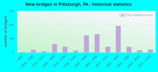
- New bridges - historical statistics
- 5Before 1900
- 211900-1909
- 101910-1919
- 631920-1929
- 431930-1939
- 161940-1949
- 1261950-1959
- 1341960-1969
- 441970-1979
- 1941980-1989
- 421990-1999
- 172000-2009
- 232010-2019
- 12020-2022
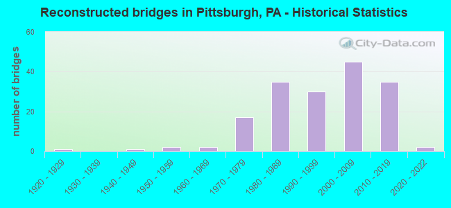
- Reconstructed bridges - Historical Statistics
- 11920-1929
- 01930-1939
- 11940-1949
- 21950-1959
- 21960-1969
- 171970-1979
- 351980-1989
- 301990-1999
- 452000-2009
- 352010-2019
- 22020-2022

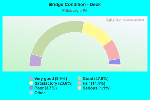
- Bridge Condition - Deck
- 8.9%Very good
- 47.6%Good
- 23.6%Satisfactory
- 14.4%Fair
- 3.7%Poor
- 1.1%Serious
- 0.7%Critical
- 0.4%Imminent failure
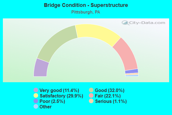
- Bridge Condition - Superstructure
- 11.4%Very good
- 32.0%Good
- 29.9%Satisfactory
- 22.1%Fair
- 2.5%Poor
- 1.1%Serious
- 1.1%Critical
- 0.7%Imminent failure
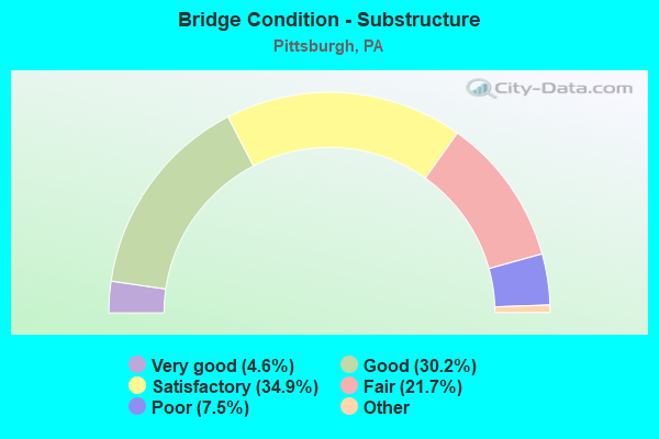
- Bridge Condition - Substructure
- 4.6%Excellent
- 30.2%Very good
- 34.9%Good
- 21.7%Satisfactory
- 7.5%Fair
- 1.1%Poor
- 0.7%Serious
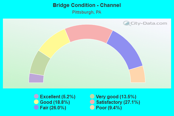
- Bridge Condition - Channel
- 5.2%Excellent
- 13.5%Very good
- 18.8%Good
- 27.1%Satisfactory
- 26.0%Fair
- 9.4%Poor
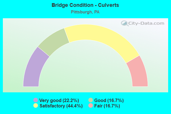
- Bridge Condition - Culverts
- 22.2%Very good
- 16.7%Good
- 44.4%Satisfactory
- 16.7%Fair
Find on map >> Show street view
Structure Number: 1222, Location: Crosstown Blvd (Lat: 40.443033, Lng: -79.992733), Route carried "under" structure: Ramp State highway , Year Built: 1986, Structure Length: 0. m, Average Daily Traffic: 7,250 (year 2021), Truck Traffic: 6%, Features Intersected: I-579 NB, SB, RAMP B, Facility Carried by Structure: BIGELOW BLVD WB
Minimum Vertical Clearance: 7.47m (24.51ft), Kilometerpoint: 0.000, Lanes on structure: 2, Lanes under structure: 1, Material/Design: Steel continuous, Design/Construction: Stringer/Multi-beam, Length of Maximum Span: 51.5m (169.0ft)
Find on map >> Show street view
Structure Number: 1222, Location: Crosstown Blvd (Lat: 40.443033, Lng: -79.992733), Route carried "under" structure: Interstate 579, Year Built: 1986, Structure Length: 0. m, Average Daily Traffic: 25,279 (year 2021), Truck Traffic: 7%, Features Intersected: I-579 NB, SB, RAMP B, Facility Carried by Structure: BIGELOW BLVD WB
Minimum Vertical Clearance: 5.23m (17.16ft), Kilometerpoint: 0.000, Lanes on structure: 2, Lanes under structure: 2, Material/Design: Steel continuous, Design/Construction: Stringer/Multi-beam, Length of Maximum Span: 51.5m (169.0ft)
Find on map >> Show street view
Structure Number: 1222, Location: Crosstown Blvd (Lat: 40.443033, Lng: -79.992733), Route carried "under" structure: Interstate 579, Year Built: 1986, Structure Length: 0. m, Average Daily Traffic: 29,197 (year 2021), Truck Traffic: 5%, Features Intersected: I-579 NB, SB, RAMP B, Facility Carried by Structure: BIGELOW BLVD WB
Minimum Vertical Clearance: 6.78m (22.24ft), Kilometerpoint: 0.000, Lanes on structure: 2, Lanes under structure: 2, Material/Design: Steel continuous, Design/Construction: Stringer/Multi-beam, Length of Maximum Span: 51.5m (169.0ft)
Find on map >> Show street view
Structure Number: 1229, Location: 1 MI.S.OF BLOOMFIELD BR. (Lat: 40.454044, Lng: -79.950550), Route carried "under" structure: Other road , Year Built: 1975, Structure Length: 0. m, Average Daily Traffic: 1 (year 2004), Truck Traffic: 1%, Features Intersected: CSX RR, PAT EAST BUSWAY, Facility Carried by Structure: BAUM BLVD
Minimum Vertical Clearance: 8.26m (27.10ft), Kilometerpoint: 0.000, Lanes on structure: 4, Lanes under structure: 2, Material/Design: Steel, Design/Construction: Stringer/Multi-beam, Length of Maximum Span: 58.5m (191.9ft)
Find on map >> Show street view
Structure Number: 1234, Location: I579 NB.OVER 5TH AVENUE (Lat: 40.439025, Lng: -79.993656), Route carried "under" structure: City street , Year Built: 1962, Structure Length: 0. m, Average Daily Traffic: 100 (year 2006), Truck Traffic: 5%, Features Intersected: FIFTH AVE, Facility Carried by Structure: CROSSTOWN BL
Minimum Vertical Clearance: 4.62m (15.16ft), Kilometerpoint: 0.000, Lanes on structure: 3, Lanes under structure: 3, Material/Design: Steel, Design/Construction: Stringer/Multi-beam, Length of Maximum Span: 23.5m (77.1ft)
Find on map >> Show street view
Structure Number: 1235, Location: CENTER AVE. OVER 1026 (Lat: 40.433333, Lng: -79.991667), Route carried "under" structure: Ramp Interstate 579, Year Built: 1962, Structure Length: 0. m, Average Daily Traffic: 29,197 (year 2021), Truck Traffic: 5%, Features Intersected: I-579, CROSSTOWN, Facility Carried by Structure: CENTER AVE
Minimum Vertical Clearance: 6.30m (20.67ft), Kilometerpoint: 0.000, Lanes on structure: 4, Lanes under structure: 6, Material/Design: Steel, Design/Construction: Stringer/Multi-beam, Length of Maximum Span: 26.2m (86.0ft)
Find on map >> Show street view
Structure Number: 1235, Location: CENTER AVE. OVER 1026 (Lat: 40.433333, Lng: -79.991667), Route carried "under" structure: Ramp Interstate 579, Year Built: 1962, Structure Length: 0. m, Average Daily Traffic: 25,279 (year 2021), Truck Traffic: 7%, Features Intersected: I-579, CROSSTOWN, Facility Carried by Structure: CENTER AVE
Minimum Vertical Clearance: 5.08m (16.67ft), Kilometerpoint: 0.000, Lanes on structure: 4, Lanes under structure: 6, Material/Design: Steel, Design/Construction: Stringer/Multi-beam, Length of Maximum Span: 26.2m (86.0ft)
Find on map >> Show street view
Structure Number: 1236, Location: WEBSTER AVE OVER I-579 (Lat: 40.433333, Lng: -79.991667), Route carried "under" structure: Ramp State highway , Year Built: 1962, Structure Length: 0. m, Average Daily Traffic: 2,919 (year 2021), Truck Traffic: 7%, Features Intersected: I-579, Facility Carried by Structure: WEBSTER AVE
Minimum Vertical Clearance: 5.18m (16.99ft), Kilometerpoint: 0.000, Lanes on structure: 3, Lanes under structure: 1, Material/Design: Steel, Design/Construction: Stringer/Multi-beam, Length of Maximum Span: 31.4m (103.0ft)
Find on map >> Show street view
Structure Number: 1236, Location: WEBSTER AVE OVER I-579 (Lat: 40.433333, Lng: -79.991667), Route carried "under" structure: Ramp State highway , Year Built: 1962, Structure Length: 0. m, Average Daily Traffic: 862 (year 2021), Truck Traffic: 7%, Features Intersected: I-579, Facility Carried by Structure: WEBSTER AVE
Minimum Vertical Clearance: 6.00m (19.69ft), Kilometerpoint: 0.000, Lanes on structure: 3, Lanes under structure: 8, Material/Design: Steel, Design/Construction: Stringer/Multi-beam, Length of Maximum Span: 31.4m (103.0ft)
Find on map >> Show street view
Structure Number: 1236, Location: WEBSTER AVE OVER I-579 (Lat: 40.433333, Lng: -79.991667), Route carried "under" structure: Interstate 579, Year Built: 1962, Structure Length: 0. m, Average Daily Traffic: 25,279 (year 2021), Truck Traffic: 7%, Features Intersected: I-579, Facility Carried by Structure: WEBSTER AVE
Minimum Vertical Clearance: 5.08m (16.67ft), Kilometerpoint: 0.000, Lanes on structure: 3, Lanes under structure: 8, Material/Design: Steel, Design/Construction: Stringer/Multi-beam, Length of Maximum Span: 31.4m (103.0ft)
Find on map >> Show street view
Structure Number: 1236, Location: WEBSTER AVE OVER I-579 (Lat: 40.433333, Lng: -79.991667), Route carried "under" structure: Interstate 579, Year Built: 1962, Structure Length: 0. m, Average Daily Traffic: 29,197 (year 2021), Truck Traffic: 5%, Features Intersected: I-579, Facility Carried by Structure: WEBSTER AVE
Minimum Vertical Clearance: 5.08m (16.67ft), Kilometerpoint: 0.000, Lanes on structure: 3, Lanes under structure: 8, Material/Design: Steel, Design/Construction: Stringer/Multi-beam, Length of Maximum Span: 31.4m (103.0ft)
Find on map >> Show street view
Structure Number: 1236, Location: WEBSTER AVE OVER I-579 (Lat: 40.433333, Lng: -79.991667), Route carried "under" structure: Ramp State highway , Year Built: 1962, Structure Length: 0. m, Average Daily Traffic: 2,934 (year 2021), Truck Traffic: 7%, Features Intersected: I-579, Facility Carried by Structure: WEBSTER AVE
Minimum Vertical Clearance: 5.97m (19.59ft), Kilometerpoint: 0.000, Lanes on structure: 3, Lanes under structure: 8, Material/Design: Steel, Design/Construction: Stringer/Multi-beam, Length of Maximum Span: 31.4m (103.0ft)
Find on map >> Show street view
Structure Number: 1237, Location: I579 SB.OVER 5TH AVENUE (Lat: 40.439106, Lng: -79.993772), Route carried "under" structure: City street , Year Built: 1962, Structure Length: 0. m, Average Daily Traffic: 5,678 (year 2006), Truck Traffic: 1%, Features Intersected: FIFTH AVE, Facility Carried by Structure: CROSSTOWN BLVD
Minimum Vertical Clearance: 4.75m (15.58ft), Kilometerpoint: 0.000, Lanes on structure: 2, Lanes under structure: 4, Material/Design: Steel, Design/Construction: Stringer/Multi-beam, Length of Maximum Span: 31.7m (104.0ft)
Find on map >> Show street view
Structure Number: 124, Location: 579 SB.OVER RAMP D (Lat: 40.441581, Lng: -79.992581), Route carried "under" structure: Ramp State highway , Year Built: 1962, Structure Length: 0. m, Average Daily Traffic: 2,919 (year 2021), Truck Traffic: 7%, Features Intersected: 7TH AVE RAMP D, Facility Carried by Structure: CROSSTOWN BLVD
Minimum Vertical Clearance: 4.72m (15.49ft), Kilometerpoint: 0.000, Lanes on structure: 3, Lanes under structure: 1, Material/Design: Steel, Design/Construction: Stringer/Multi-beam, Length of Maximum Span: 18.9m (62.0ft)
Find on map >> Show street view
Structure Number: 1241, Location: Veterans Bridge (Lat: 40.447958, Lng: -79.991092), Route carried "under" structure: City street , Year Built: 1986, Structure Length: 0. m, Average Daily Traffic: 10,000 (year 2001), Truck Traffic: 10%, Features Intersected: N-S RR,PAT LRT,PAT EBSWY, Facility Carried by Structure: I-579 NB
Minimum Vertical Clearance: 13.79m (45.24ft), Kilometerpoint: 0.000, Lanes on structure: 2, Lanes under structure: 5, Material/Design: Steel continuous, Design/Construction: Stringer/Multi-beam, Length of Maximum Span: 59.4m (194.9ft)
Find on map >> Show street view
Structure Number: 1241, Location: Veterans Bridge (Lat: 40.447958, Lng: -79.991092), Route carried "under" structure: Other road , Year Built: 1986, Structure Length: 0. m, Average Daily Traffic: 4,000 (year 2001), Truck Traffic: 5%, Features Intersected: N-S RR,PAT LRT,PAT EBSWY, Facility Carried by Structure: I-579 NB
Minimum Vertical Clearance: 8.53m (27.99ft), Kilometerpoint: 0.000, Lanes on structure: 2, Lanes under structure: 5, Material/Design: Steel continuous, Design/Construction: Stringer/Multi-beam, Length of Maximum Span: 59.4m (194.9ft)
Find on map >> Show street view
Structure Number: 1245, Location: Veterans Bridge (Lat: 40.446497, Lng: -79.990544), Route carried "under" structure: Other road , Year Built: 1986, Structure Length: 0. m, Average Daily Traffic: 4,000 (year 2001), Features Intersected: N-S RR,PAT LRT,PAT EBSWY, Facility Carried by Structure: I-579 SB
Minimum Vertical Clearance: 7.38m (24.21ft), Kilometerpoint: 0.000, Lanes on structure: 2, Lanes under structure: 5, Material/Design: Steel continuous, Design/Construction: Stringer/Multi-beam, Length of Maximum Span: 65.8m (215.9ft)
Find on map >> Show street view
Structure Number: 1245, Location: Veterans Bridge (Lat: 40.446497, Lng: -79.990544), Route carried "under" structure: City street , Year Built: 1986, Structure Length: 0. m, Average Daily Traffic: 10,000 (year 2001), Truck Traffic: 10%, Features Intersected: N-S RR,PAT LRT,PAT EBSWY, Facility Carried by Structure: I-579 SB
Minimum Vertical Clearance: 12.68m (41.60ft), Kilometerpoint: 0.000, Lanes on structure: 2, Lanes under structure: 5, Material/Design: Steel continuous, Design/Construction: Stringer/Multi-beam, Length of Maximum Span: 65.8m (215.9ft)
Find on map >> Show street view
Structure Number: 1248, Location: Vets Bridge N. Appr (Lat: 40.452958, Lng: -79.996394), Route carried "under" structure: State highway 28, Year Built: 1988, Structure Length: 0. m, Average Daily Traffic: 11,707 (year 2022), Truck Traffic: 3%, Features Intersected: SR28, 8108,EAST OHIO ST., Facility Carried by Structure: I-579 NB
Minimum Vertical Clearance: 17.88m (58.66ft), Kilometerpoint: 0.604, Lanes on structure: 2, Lanes under structure: 2, Material/Design: Steel continuous, Design/Construction: Stringer/Multi-beam, Length of Maximum Span: 50.0m (164.0ft)
Find on map >> Show street view
Structure Number: 1248, Location: Vets Bridge N. Appr (Lat: 40.452958, Lng: -79.996394), Route carried "under" structure: Ramp State highway , Year Built: 1988, Structure Length: 0. m, Average Daily Traffic: 9,115 (year 2021), Truck Traffic: 5%, Features Intersected: SR28, 8108,EAST OHIO ST., Facility Carried by Structure: I-579 NB
Minimum Vertical Clearance: 7.75m (25.43ft), Kilometerpoint: 0.000, Lanes on structure: 2, Lanes under structure: 1, Material/Design: Steel continuous, Design/Construction: Stringer/Multi-beam, Length of Maximum Span: 50.0m (164.0ft)
Find on map >> Show street view
Structure Number: 1248, Location: Vets Bridge N. Appr (Lat: 40.452958, Lng: -79.996394), Route carried "under" structure: Ramp State highway , Year Built: 1988, Structure Length: 0. m, Average Daily Traffic: 14,888 (year 2021), Truck Traffic: 7%, Features Intersected: SR28, 8108,EAST OHIO ST., Facility Carried by Structure: I-579 NB
Minimum Vertical Clearance: 5.37m (17.62ft), Kilometerpoint: 0.000, Lanes on structure: 2, Lanes under structure: 1, Material/Design: Steel continuous, Design/Construction: Stringer/Multi-beam, Length of Maximum Span: 50.0m (164.0ft)
Find on map >> Show street view
Structure Number: 1248, Location: Vets Bridge N. Appr (Lat: 40.452958, Lng: -79.996394), Route carried "under" structure: State highway 28, Year Built: 1988, Structure Length: 0. m, Average Daily Traffic: 7,220 (year 2022), Truck Traffic: 3%, Features Intersected: SR28, 8108,EAST OHIO ST., Facility Carried by Structure: I-579 NB
Minimum Vertical Clearance: 11.56m (37.93ft), Kilometerpoint: 0.571, Lanes on structure: 2, Lanes under structure: 2, Material/Design: Steel continuous, Design/Construction: Stringer/Multi-beam, Length of Maximum Span: 50.0m (164.0ft)
Find on map >> Show street view
Structure Number: 1248, Location: Vets Bridge N. Appr (Lat: 40.452958, Lng: -79.996394), Route carried "under" structure: State highway , Year Built: 1988, Structure Length: 0. m, Average Daily Traffic: 11,236 (year 2022), Truck Traffic: 9%, Features Intersected: SR28, 8108,EAST OHIO ST., Facility Carried by Structure: I-579 NB
Minimum Vertical Clearance: 4.57m (14.99ft), Kilometerpoint: 0.021, Lanes on structure: 2, Lanes under structure: 2, Material/Design: Steel continuous, Design/Construction: Stringer/Multi-beam, Length of Maximum Span: 50.0m (164.0ft)
Find on map >> Show street view
Structure Number: 1248, Location: Vets Bridge N. Appr (Lat: 40.452958, Lng: -79.996394), Route carried "under" structure: State highway , Year Built: 1988, Structure Length: 0. m, Average Daily Traffic: 10,936 (year 2022), Truck Traffic: 7%, Features Intersected: SR28, 8108,EAST OHIO ST., Facility Carried by Structure: I-579 NB
Minimum Vertical Clearance: 4.75m (15.58ft), Kilometerpoint: 0.021, Lanes on structure: 2, Lanes under structure: 2, Material/Design: Steel continuous, Design/Construction: Stringer/Multi-beam, Length of Maximum Span: 50.0m (164.0ft)
Find on map >> Show street view
Structure Number: 1254, Location: Veterans Bridge (Lat: 40.452308, Lng: -79.996325), Route carried "under" structure: State highway , Year Built: 1988, Structure Length: 0. m, Average Daily Traffic: 11,236 (year 2022), Truck Traffic: 9%, Features Intersected: 279,28,HOV,N&S RR,E.OHIO, Facility Carried by Structure: I-579 SB
Minimum Vertical Clearance: 4.66m (15.29ft), Kilometerpoint: 0.021, Lanes on structure: 2, Lanes under structure: 2, Material/Design: Steel continuous, Design/Construction: Stringer/Multi-beam, Length of Maximum Span: 53.6m (175.9ft)
Find on map >> Show street view
Structure Number: 1254, Location: Veterans Bridge (Lat: 40.452308, Lng: -79.996325), Route carried "under" structure: Ramp State highway , Year Built: 1988, Structure Length: 0. m, Average Daily Traffic: 14,888 (year 2021), Truck Traffic: 7%, Features Intersected: 279,28,HOV,N&S RR,E.OHIO, Facility Carried by Structure: I-579 SB
Minimum Vertical Clearance: 5.29m (17.36ft), Kilometerpoint: 0.000, Lanes on structure: 2, Lanes under structure: 1, Material/Design: Steel continuous, Design/Construction: Stringer/Multi-beam, Length of Maximum Span: 53.6m (175.9ft)
Find on map >> Show street view
Structure Number: 1254, Location: Veterans Bridge (Lat: 40.452308, Lng: -79.996325), Route carried "under" structure: Interstate 279, Year Built: 1988, Structure Length: 0. m, Average Daily Traffic: 13,726 (year 2022), Truck Traffic: 8%, Features Intersected: 279,28,HOV,N&S RR,E.OHIO, Facility Carried by Structure: I-579 SB
Minimum Vertical Clearance: 13.97m (45.83ft), Kilometerpoint: 1.754, Lanes on structure: 2, Lanes under structure: 2, Material/Design: Steel continuous, Design/Construction: Stringer/Multi-beam, Length of Maximum Span: 53.6m (175.9ft)
Find on map >> Show street view
Structure Number: 1254, Location: Veterans Bridge (Lat: 40.452308, Lng: -79.996325), Route carried "under" structure: State highway , Year Built: 1988, Structure Length: 0. m, Average Daily Traffic: 10,936 (year 2022), Truck Traffic: 7%, Features Intersected: 279,28,HOV,N&S RR,E.OHIO, Facility Carried by Structure: I-579 SB
Minimum Vertical Clearance: 4.60m (15.09ft), Kilometerpoint: 0.021, Lanes on structure: 2, Lanes under structure: 2, Material/Design: Steel continuous, Design/Construction: Stringer/Multi-beam, Length of Maximum Span: 53.6m (175.9ft)
Find on map >> Show street view
Structure Number: 1254, Location: Veterans Bridge (Lat: 40.452308, Lng: -79.996325), Route carried "under" structure: State highway 28, Year Built: 1988, Structure Length: 0. m, Average Daily Traffic: 11,707 (year 2022), Truck Traffic: 3%, Features Intersected: 279,28,HOV,N&S RR,E.OHIO, Facility Carried by Structure: I-579 SB
Minimum Vertical Clearance: 14.00m (45.93ft), Kilometerpoint: 0.000, Lanes on structure: 2, Lanes under structure: 3, Material/Design: Steel continuous, Design/Construction: Stringer/Multi-beam, Length of Maximum Span: 53.6m (175.9ft)
Find on map >> Show street view
Structure Number: 1254, Location: Veterans Bridge (Lat: 40.452308, Lng: -79.996325), Route carried "under" structure: Ramp State highway , Year Built: 1988, Structure Length: 0. m, Average Daily Traffic: 9,115 (year 2021), Truck Traffic: 5%, Features Intersected: 279,28,HOV,N&S RR,E.OHIO, Facility Carried by Structure: I-579 SB
Minimum Vertical Clearance: 5.13m (16.83ft), Kilometerpoint: 0.000, Lanes on structure: 2, Lanes under structure: 1, Material/Design: Steel continuous, Design/Construction: Stringer/Multi-beam, Length of Maximum Span: 53.6m (175.9ft)
Find on map >> Show street view
Structure Number: 1254, Location: Veterans Bridge (Lat: 40.452308, Lng: -79.996325), Route carried "under" structure: Interstate 279, Year Built: 1988, Structure Length: 0. m, Average Daily Traffic: 586 (year 2021), Truck Traffic: 4%, Features Intersected: 279,28,HOV,N&S RR,E.OHIO, Facility Carried by Structure: I-579 SB
Minimum Vertical Clearance: 13.89m (45.57ft), Kilometerpoint: 1.006, Lanes on structure: 2, Lanes under structure: 1, Material/Design: Steel continuous, Design/Construction: Stringer/Multi-beam, Length of Maximum Span: 53.6m (175.9ft)
Find on map >> Show street view
Structure Number: 1254, Location: Veterans Bridge (Lat: 40.452308, Lng: -79.996325), Route carried "under" structure: Interstate 279, Year Built: 1988, Structure Length: 0. m, Average Daily Traffic: 14,673 (year 2022), Truck Traffic: 8%, Features Intersected: 279,28,HOV,N&S RR,E.OHIO, Facility Carried by Structure: I-579 SB
Minimum Vertical Clearance: 13.97m (45.83ft), Kilometerpoint: 1.719, Lanes on structure: 2, Lanes under structure: 2, Material/Design: Steel continuous, Design/Construction: Stringer/Multi-beam, Length of Maximum Span: 53.6m (175.9ft)
Find on map >> Show street view
Structure Number: 1254, Location: Veterans Bridge (Lat: 40.452308, Lng: -79.996325), Route carried "under" structure: State highway 28, Year Built: 1988, Structure Length: 0. m, Average Daily Traffic: 7,220 (year 2022), Truck Traffic: 3%, Features Intersected: 279,28,HOV,N&S RR,E.OHIO, Facility Carried by Structure: I-579 SB
Minimum Vertical Clearance: 14.00m (45.93ft), Kilometerpoint: 0.000, Lanes on structure: 2, Lanes under structure: 2, Material/Design: Steel continuous, Design/Construction: Stringer/Multi-beam, Length of Maximum Span: 53.6m (175.9ft)
Find on map >> Show street view
Structure Number: 1286, Location: Homestead Interchange (Lat: 40.405167, Lng: -79.885339), Route carried "under" structure: Ramp State highway , Year Built: 1966, Structure Length: 0. m, Average Daily Traffic: 7,413 (year 2022), Truck Traffic: 4%, Features Intersected: RPS. C&D,RP.CARSON,LOCAL, Facility Carried by Structure: SR 837 SB
Minimum Vertical Clearance: 4.50m (14.76ft), Kilometerpoint: 0.000, Lanes on structure: 2, Lanes under structure: 1, Material/Design: Steel, Design/Construction: Stringer/Multi-beam, Length of Maximum Span: 25.9m (85.0ft)
Find on map >> Show street view
Structure Number: 1286, Location: Homestead Interchange (Lat: 40.405167, Lng: -79.885339), Route carried "under" structure: City street , Year Built: 1966, Structure Length: 0. m, Average Daily Traffic: 300 (year 2005), Truck Traffic: 7%, Features Intersected: RPS. C&D,RP.CARSON,LOCAL, Facility Carried by Structure: SR 837 SB
Minimum Vertical Clearance: 6.40m (21.00ft), Kilometerpoint: 0.000, Lanes on structure: 2, Lanes under structure: 2, Material/Design: Steel, Design/Construction: Stringer/Multi-beam, Length of Maximum Span: 25.9m (85.0ft)
Find on map >> Show street view
Structure Number: 1286, Location: Homestead Interchange (Lat: 40.405167, Lng: -79.885339), Route carried "under" structure: Ramp State highway , Year Built: 1966, Structure Length: 0. m, Average Daily Traffic: 5,441 (year 2022), Truck Traffic: 7%, Features Intersected: RPS. C&D,RP.CARSON,LOCAL, Facility Carried by Structure: SR 837 SB
Minimum Vertical Clearance: 30+ m (98+ ft), Kilometerpoint: 0.000, Lanes on structure: 2, Lanes under structure: 1, Material/Design: Steel, Design/Construction: Stringer/Multi-beam, Length of Maximum Span: 25.9m (85.0ft)
Find on map >> Show street view
Structure Number: 1286, Location: Homestead Interchange (Lat: 40.405167, Lng: -79.885339), Route carried "under" structure: Ramp State highway , Year Built: 1966, Structure Length: 0. m, Average Daily Traffic: 2,639 (year 2022), Truck Traffic: 7%, Features Intersected: RPS. C&D,RP.CARSON,LOCAL, Facility Carried by Structure: SR 837 SB
Minimum Vertical Clearance: 4.95m (16.24ft), Kilometerpoint: 0.000, Lanes on structure: 2, Lanes under structure: 1, Material/Design: Steel, Design/Construction: Stringer/Multi-beam, Length of Maximum Span: 25.9m (85.0ft)
Find on map >> Show street view
Structure Number: 1294, Location: @ SOUTH END / WEST END BR (Lat: 40.444058, Lng: -80.027978), Route carried "under" structure: Ramp State highway , Year Built: 1991, Structure Length: 0. m, Average Daily Traffic: 4,130 (year 2022), Truck Traffic: 9%, Features Intersected: W. CARSON ST., SR 3106, Facility Carried by Structure: WEST END CIRCLE
Minimum Vertical Clearance: 5.31m (17.42ft), Kilometerpoint: 0.000, Lanes on structure: 5, Lanes under structure: 2, Material/Design: Steel continuous, Design/Construction: Stringer/Multi-beam, Length of Maximum Span: 8.5m (27.9ft)
Find on map >> Show street view
Structure Number: 1294, Location: @ SOUTH END / WEST END BR (Lat: 40.444058, Lng: -80.027978), Route carried "under" structure: Ramp State highway , Year Built: 1991, Structure Length: 0. m, Average Daily Traffic: 7,671 (year 2022), Truck Traffic: 7%, Features Intersected: W. CARSON ST., SR 3106, Facility Carried by Structure: WEST END CIRCLE
Minimum Vertical Clearance: 4.52m (14.83ft), Kilometerpoint: 0.000, Lanes on structure: 5, Lanes under structure: 2, Material/Design: Steel continuous, Design/Construction: Stringer/Multi-beam, Length of Maximum Span: 8.5m (27.9ft)
Find on map >> Show street view
Structure Number: 1302, Location: 1/2 MI. N.W.OF SR2045 (Lat: 40.384656, Lng: -79.932856), Route carried "under" structure: Ramp State highway , Year Built: 1963, Structure Length: 0. m, Average Daily Traffic: 974 (year 2022), Truck Traffic: 7%, Features Intersected: BALDWIN RD,RR,RAMP ST,CR, Facility Carried by Structure: LEBANON ROAD
Minimum Vertical Clearance: 5.33m (17.49ft), Kilometerpoint: 0.000, Lanes on structure: 4, Lanes under structure: 3, Material/Design: Prestressed concrete, Design/Construction: Stringer/Multi-beam, Length of Maximum Span: 31.1m (102.0ft)
Find on map >> Show street view
Structure Number: 1302, Location: 1/2 MI. N.W.OF SR2045 (Lat: 40.384656, Lng: -79.932856), Route carried "under" structure: State highway , Year Built: 1963, Structure Length: 0. m, Average Daily Traffic: 3,502 (year 2021), Truck Traffic: 5%, Features Intersected: BALDWIN RD,RR,RAMP ST,CR, Facility Carried by Structure: LEBANON ROAD
Minimum Vertical Clearance: 15.24m (50.00ft), Kilometerpoint: 7.033, Lanes on structure: 4, Lanes under structure: 3, Material/Design: Prestressed concrete, Design/Construction: Stringer/Multi-beam, Length of Maximum Span: 31.1m (102.0ft)
Find on map >> Show street view
Structure Number: 1304, Location: AT GLENWOOD INTERCHANGE (Lat: 40.389658, Lng: -79.934100), Route carried "under" structure: State highway , Year Built: 1963, Structure Length: 0. m, Average Daily Traffic: 1,942 (year 2021), Truck Traffic: 13%, Features Intersected: GLASS RUN ROAD, Facility Carried by Structure: MIFFLIN ROAD
Minimum Vertical Clearance: 4.57m (14.99ft), Kilometerpoint: 4.281, Lanes on structure: 2, Lanes under structure: 2, Material/Design: Prestressed concrete, Design/Construction: Box Beam or Girders - Single/Spread, Length of Maximum Span: 21.9m (71.9ft)
Find on map >> Show street view
Structure Number: 1304, Location: AT GLENWOOD INTERCHANGE (Lat: 40.389658, Lng: -79.934100), Route carried "under" structure: State highway , Year Built: 1963, Structure Length: 0. m, Average Daily Traffic: 2,922 (year 2022), Truck Traffic: 2%, Features Intersected: GLASS RUN ROAD, Facility Carried by Structure: MIFFLIN ROAD
Minimum Vertical Clearance: 4.42m (14.50ft), Kilometerpoint: 4.281, Lanes on structure: 2, Lanes under structure: 2, Material/Design: Prestressed concrete, Design/Construction: Box Beam or Girders - Single/Spread, Length of Maximum Span: 21.9m (71.9ft)
Find on map >> Show street view
Structure Number: 1307, Location: AT GLENWOOD INTERCHANGE (Lat: 40.391744, Lng: -79.934525), Route carried "under" structure: State highway , Year Built: 1967, Structure Length: 0. m, Average Daily Traffic: 5,441 (year 2022), Truck Traffic: 7%, Features Intersected: SR 8059, Facility Carried by Structure: MIFFLIN RD
Minimum Vertical Clearance: 4.40m (14.44ft), Kilometerpoint: 0.000, Lanes on structure: 3, Lanes under structure: 2, Material/Design: Prestressed concrete, Design/Construction: Box Beam or Girders - Single/Spread, Length of Maximum Span: 16.5m (54.1ft)
Find on map >> Show street view
Structure Number: 1309, Location: GLENWOOD INTERCHANGE (Lat: 40.393253, Lng: -79.934831), Route carried "under" structure: Ramp State highway , Year Built: 1967, Structure Length: 0. m, Average Daily Traffic: 8,048 (year 2022), Truck Traffic: 7%, Features Intersected: SR 8059(RAMP A), Facility Carried by Structure: MIFFLIN RD
Minimum Vertical Clearance: 4.57m (14.99ft), Kilometerpoint: 0.000, Lanes on structure: 4, Lanes under structure: 2, Material/Design: Prestressed concrete, Design/Construction: Box Beam or Girders - Single/Spread, Length of Maximum Span: 21.9m (71.9ft)
Find on map >> Show street view
Structure Number: 131, Location: MA08 GLENWOOD BRIDGE (Lat: 40.397828, Lng: -79.935614), Route carried "under" structure: State highway 837, Year Built: 1966, Structure Length: 0. m, Average Daily Traffic: 7,251 (year 2021), Truck Traffic: 9%, Features Intersected: MON R,3 RRS,CARSON ST, Facility Carried by Structure: GLENWOOD BR
Minimum Vertical Clearance: 14.63m (48.00ft), Kilometerpoint: 28.115, Lanes on structure: 4, Lanes under structure: 2, Material/Design: Steel continuous, Design/Construction: Truss - Deck, Length of Maximum Span: 172.8m (566.9ft)
Find on map >> Show street view
Structure Number: 131, Location: MA08 GLENWOOD BRIDGE (Lat: 40.397828, Lng: -79.935614), Route carried "under" structure: State highway 837, Year Built: 1966, Structure Length: 0. m, Average Daily Traffic: 7,251 (year 2021), Truck Traffic: 9%, Features Intersected: MON R,3 RRS,CARSON ST, Facility Carried by Structure: GLENWOOD BR
Minimum Vertical Clearance: 14.63m (48.00ft), Kilometerpoint: 28.099, Lanes on structure: 4, Lanes under structure: 2, Material/Design: Steel continuous, Design/Construction: Truss - Deck, Length of Maximum Span: 172.8m (566.9ft)
Find on map >> Show street view
Structure Number: 132, Location: Birmingham Bridge (Lat: 40.433333, Lng: -79.966667), Route carried "under" structure: Ramp State highway , Year Built: 1928, Structure Length: 0. m, Average Daily Traffic: 9,850 (year 2019), Truck Traffic: 7%, Features Intersected: FORBES, BIRM E&F, BRADY, Facility Carried by Structure: BLVD ALLIES WB
Minimum Vertical Clearance: 5.94m (19.49ft), Kilometerpoint: 0.000, Lanes on structure: 2, Lanes under structure: 1, Material/Design: Steel, Design/Construction: Stringer/Multi-beam, Length of Maximum Span: 20.4m (66.9ft)
Find on map >> Show street view
Structure Number: 132, Location: Birmingham Bridge (Lat: 40.433333, Lng: -79.966667), Route carried "under" structure: Ramp State highway , Year Built: 1928, Structure Length: 0. m, Average Daily Traffic: 7,534 (year 2021), Truck Traffic: 7%, Features Intersected: FORBES, BIRM E&F, BRADY, Facility Carried by Structure: BLVD ALLIES WB
Minimum Vertical Clearance: 30+ m (98+ ft), Kilometerpoint: 0.000, Lanes on structure: 2, Lanes under structure: 1, Material/Design: Steel, Design/Construction: Stringer/Multi-beam, Length of Maximum Span: 20.4m (66.9ft)
Find on map >> Show street view
Structure Number: 132, Location: Birmingham Bridge (Lat: 40.433333, Lng: -79.966667), Route carried "under" structure: City street , Year Built: 1928, Structure Length: 0. m, Average Daily Traffic: 2,000 (year 2017), Truck Traffic: 5%, Features Intersected: FORBES, BIRM E&F, BRADY, Facility Carried by Structure: BLVD ALLIES WB
Minimum Vertical Clearance: 9.24m (30.31ft), Kilometerpoint: 0.000, Lanes on structure: 2, Lanes under structure: 2, Material/Design: Steel, Design/Construction: Stringer/Multi-beam, Length of Maximum Span: 20.4m (66.9ft)
Find on map >> Show street view
Structure Number: 132, Location: Birmingham Bridge (Lat: 40.433333, Lng: -79.966667), Route carried "under" structure: Ramp State highway , Year Built: 1928, Structure Length: 0. m, Average Daily Traffic: 3,007 (year 2022), Truck Traffic: 7%, Features Intersected: FORBES, BIRM E&F, BRADY, Facility Carried by Structure: BLVD ALLIES WB
Minimum Vertical Clearance: 5.89m (19.32ft), Kilometerpoint: 0.000, Lanes on structure: 2, Lanes under structure: 1, Material/Design: Steel, Design/Construction: Stringer/Multi-beam, Length of Maximum Span: 20.4m (66.9ft)
Find on map >> Show street view
Structure Number: 132, Location: Birmingham Bridge (Lat: 40.433333, Lng: -79.966667), Route carried "under" structure: State highway , Year Built: 1928, Structure Length: 0. m, Average Daily Traffic: 6,578 (year 2021), Truck Traffic: 12%, Features Intersected: FORBES, BIRM E&F, BRADY, Facility Carried by Structure: BLVD ALLIES WB
Minimum Vertical Clearance: 4.29m (14.07ft), Kilometerpoint: 0.000, Lanes on structure: 2, Lanes under structure: 2, Material/Design: Steel, Design/Construction: Stringer/Multi-beam, Length of Maximum Span: 20.4m (66.9ft)
Find on map >> Show street view
Structure Number: 132, Location: Birmingham Bridge (Lat: 40.433333, Lng: -79.966667), Route carried "under" structure: Ramp State highway , Year Built: 1928, Structure Length: 0. m, Average Daily Traffic: 5,699 (year 2022), Truck Traffic: 7%, Features Intersected: FORBES, BIRM E&F, BRADY, Facility Carried by Structure: BLVD ALLIES WB
Minimum Vertical Clearance: 5.31m (17.42ft), Kilometerpoint: 0.000, Lanes on structure: 2, Lanes under structure: 1, Material/Design: Steel, Design/Construction: Stringer/Multi-beam, Length of Maximum Span: 20.4m (66.9ft)
Find on map >> Show street view
Structure Number: 1321, Location: Birmingham Bridge (Lat: 40.433333, Lng: -79.966667), Route carried "under" structure: State highway , Year Built: 1952, Structure Length: 0. m, Average Daily Traffic: 6,578 (year 2021), Truck Traffic: 12%, Features Intersected: RAMP R,02266 RPS.,FORBES, Facility Carried by Structure: RAMP S
Minimum Vertical Clearance: 4.44m (14.57ft), Kilometerpoint: 0.000, Lanes on structure: 2, Lanes under structure: 1, Material/Design: Steel continuous, Design/Construction: Stringer/Multi-beam, Length of Maximum Span: 30.2m (99.1ft)
Find on map >> Show street view
Structure Number: 1321, Location: Birmingham Bridge (Lat: 40.433333, Lng: -79.966667), Route carried "under" structure: Ramp State highway , Year Built: 1952, Structure Length: 0. m, Average Daily Traffic: 5,699 (year 2022), Truck Traffic: 7%, Features Intersected: RAMP R,02266 RPS.,FORBES, Facility Carried by Structure: RAMP S
Minimum Vertical Clearance: 5.61m (18.41ft), Kilometerpoint: 0.000, Lanes on structure: 2, Lanes under structure: 1, Material/Design: Steel continuous, Design/Construction: Stringer/Multi-beam, Length of Maximum Span: 30.2m (99.1ft)
Find on map >> Show street view
Structure Number: 1321, Location: Birmingham Bridge (Lat: 40.433333, Lng: -79.966667), Route carried "under" structure: Ramp State highway , Year Built: 1952, Structure Length: 0. m, Average Daily Traffic: 7,534 (year 2021), Truck Traffic: 7%, Features Intersected: RAMP R,02266 RPS.,FORBES, Facility Carried by Structure: RAMP S
Minimum Vertical Clearance: 4.50m (14.76ft), Kilometerpoint: 0.000, Lanes on structure: 2, Lanes under structure: 1, Material/Design: Steel continuous, Design/Construction: Stringer/Multi-beam, Length of Maximum Span: 30.2m (99.1ft)
Find on map >> Show street view
Structure Number: 1321, Location: Birmingham Bridge (Lat: 40.433333, Lng: -79.966667), Route carried "under" structure: Ramp State highway , Year Built: 1952, Structure Length: 0. m, Average Daily Traffic: 5,199 (year 2021), Truck Traffic: 7%, Features Intersected: RAMP R,02266 RPS.,FORBES, Facility Carried by Structure: RAMP S
Minimum Vertical Clearance: 8.23m (27.00ft), Kilometerpoint: 0.000, Lanes on structure: 2, Lanes under structure: 1, Material/Design: Steel continuous, Design/Construction: Stringer/Multi-beam, Length of Maximum Span: 30.2m (99.1ft)
Find on map >> Show street view
Structure Number: 1321, Location: Birmingham Bridge (Lat: 40.433333, Lng: -79.966667), Route carried "under" structure: Ramp State highway , Year Built: 1952, Structure Length: 0. m, Average Daily Traffic: 3,007 (year 2022), Truck Traffic: 7%, Features Intersected: RAMP R,02266 RPS.,FORBES, Facility Carried by Structure: RAMP S
Minimum Vertical Clearance: 5.61m (18.41ft), Kilometerpoint: 0.000, Lanes on structure: 2, Lanes under structure: 1, Material/Design: Steel continuous, Design/Construction: Stringer/Multi-beam, Length of Maximum Span: 30.2m (99.1ft)
Find on map >> Show street view
Structure Number: 138, Location: Highland Park Bridge (Lat: 40.486083, Lng: -79.913444), Route carried "under" structure: State highway 8, Year Built: 1940, Structure Length: 0. m, Average Daily Traffic: 13,106 (year 2009), Truck Traffic: 7%, Features Intersected: NS RR, ALLEGH R, AVR RR, Facility Carried by Structure: HIGHLAND PARK BRG
Minimum Vertical Clearance: 4.72m (15.49ft), Kilometerpoint: 8.352, Lanes on structure: 4, Lanes under structure: 4, Material/Design: Steel continuous, Design/Construction: Truss - Deck, Length of Maximum Span: 84.7m (277.9ft)
Find on map >> Show street view
Structure Number: 1642, Location: Birmingham Bridge (Lat: 40.436122, Lng: -79.972878), Route carried "under" structure: Ramp State highway , Year Built: 1976, Structure Length: 0. m, Average Daily Traffic: 11,205 (year 2021), Truck Traffic: 7%, Features Intersected: PKWY E,RP T,TRAIL,2ND AV, Facility Carried by Structure: BIRMINGHAM BRG APR
Minimum Vertical Clearance: 5.03m (16.50ft), Kilometerpoint: 0.000, Lanes on structure: 2, Lanes under structure: 1, Material/Design: Steel continuous, Design/Construction: Stringer/Multi-beam, Length of Maximum Span: 56.7m (186.0ft)
Find on map >> Show street view
Structure Number: 1642, Location: Birmingham Bridge (Lat: 40.436122, Lng: -79.972878), Route carried "under" structure: Interstate 376, Year Built: 1976, Structure Length: 0. m, Average Daily Traffic: 22,961 (year 2022), Truck Traffic: 8%, Features Intersected: PKWY E,RP T,TRAIL,2ND AV, Facility Carried by Structure: BIRMINGHAM BRG APR
Minimum Vertical Clearance: 15.69m (51.48ft), Kilometerpoint: 36.709, Lanes on structure: 2, Lanes under structure: 2, Material/Design: Steel continuous, Design/Construction: Stringer/Multi-beam, Length of Maximum Span: 56.7m (186.0ft)
Find on map >> Show street view
Structure Number: 1642, Location: Birmingham Bridge (Lat: 40.436122, Lng: -79.972878), Route carried "under" structure: Interstate 376, Year Built: 1976, Structure Length: 0. m, Average Daily Traffic: 22,859 (year 2022), Truck Traffic: 8%, Features Intersected: PKWY E,RP T,TRAIL,2ND AV, Facility Carried by Structure: BIRMINGHAM BRG APR
Minimum Vertical Clearance: 16.00m (52.49ft), Kilometerpoint: 36.662, Lanes on structure: 2, Lanes under structure: 2, Material/Design: Steel continuous, Design/Construction: Stringer/Multi-beam, Length of Maximum Span: 56.7m (186.0ft)
Find on map >> Show street view
Structure Number: 1642, Location: Birmingham Bridge (Lat: 40.436122, Lng: -79.972878), Route carried "under" structure: Ramp State highway , Year Built: 1976, Structure Length: 0. m, Average Daily Traffic: 7,534 (year 2021), Truck Traffic: 7%, Features Intersected: PKWY E,RP T,TRAIL,2ND AV, Facility Carried by Structure: BIRMINGHAM BRG APR
Minimum Vertical Clearance: 4.50m (14.76ft), Kilometerpoint: 0.000, Lanes on structure: 2, Lanes under structure: 1, Material/Design: Steel continuous, Design/Construction: Stringer/Multi-beam, Length of Maximum Span: 56.7m (186.0ft)
Find on map >> Show street view
Structure Number: 1642, Location: Birmingham Bridge (Lat: 40.436122, Lng: -79.972878), Route carried "under" structure: Business State highway 885, Year Built: 1976, Structure Length: 0. m, Average Daily Traffic: 12,689 (year 2020), Truck Traffic: 3%, Features Intersected: PKWY E,RP T,TRAIL,2ND AV, Facility Carried by Structure: BIRMINGHAM BRG APR
Minimum Vertical Clearance: 4.76m (15.62ft), Kilometerpoint: 20.258, Lanes on structure: 2, Lanes under structure: 1, Material/Design: Steel continuous, Design/Construction: Stringer/Multi-beam, Length of Maximum Span: 56.7m (186.0ft)
Find on map >> Show street view
Structure Number: 1642, Location: Birmingham Bridge (Lat: 40.436122, Lng: -79.972878), Route carried "under" structure: Ramp State highway , Year Built: 1976, Structure Length: 0. m, Average Daily Traffic: 5,199 (year 2021), Truck Traffic: 7%, Features Intersected: PKWY E,RP T,TRAIL,2ND AV, Facility Carried by Structure: BIRMINGHAM BRG APR
Minimum Vertical Clearance: 4.52m (14.83ft), Kilometerpoint: 0.000, Lanes on structure: 2, Lanes under structure: 1, Material/Design: Steel continuous, Design/Construction: Stringer/Multi-beam, Length of Maximum Span: 56.7m (186.0ft)
Find on map >> Show street view
Structure Number: 1642, Location: Birmingham Bridge (Lat: 40.436122, Lng: -79.972878), Route carried "under" structure: Business State highway 885, Year Built: 1976, Structure Length: 0. m, Average Daily Traffic: 8,060 (year 2020), Truck Traffic: 4%, Features Intersected: PKWY E,RP T,TRAIL,2ND AV, Facility Carried by Structure: BIRMINGHAM BRG APR
Minimum Vertical Clearance: 4.74m (15.55ft), Kilometerpoint: 20.246, Lanes on structure: 2, Lanes under structure: 2, Material/Design: Steel continuous, Design/Construction: Stringer/Multi-beam, Length of Maximum Span: 56.7m (186.0ft)
Find on map >> Show street view
Structure Number: 1642, Location: Birmingham Bridge (Lat: 40.436122, Lng: -79.972878), Route carried "under" structure: Ramp State highway , Year Built: 1976, Structure Length: 0. m, Average Daily Traffic: 4,458 (year 2021), Truck Traffic: 7%, Features Intersected: PKWY E,RP T,TRAIL,2ND AV, Facility Carried by Structure: BIRMINGHAM BRG APR
Minimum Vertical Clearance: 15.82m (51.90ft), Kilometerpoint: 0.000, Lanes on structure: 2, Lanes under structure: 1, Material/Design: Steel continuous, Design/Construction: Stringer/Multi-beam, Length of Maximum Span: 56.7m (186.0ft)
Find on map >> Show street view
Structure Number: 1655, Location: 0.1 NE OF BEECHWOOD BLVD (Lat: 40.427614, Lng: -79.927886), Route carried "under" structure: Ramp State highway , Year Built: 1952, Structure Length: 0. m, Average Daily Traffic: 10,596 (year 2021), Truck Traffic: 7%, Features Intersected: BEECHWOOD BLVD, Facility Carried by Structure: FORWARD AVE
Minimum Vertical Clearance: 4.62m (15.16ft), Kilometerpoint: 0.000, Lanes on structure: 2, Lanes under structure: 1, Material/Design: Concrete, Design/Construction: Frame, Length of Maximum Span: 8.5m (27.9ft)
Find on map >> Show street view
Structure Number: 1672, Location: 31st Street Bridge (Lat: 40.464611, Lng: -79.980061), Route carried "under" structure: ServiceOther road , Year Built: 1928, Structure Length: 0. m, Average Daily Traffic: 100 (year 2000), Truck Traffic: 5%, Features Intersected: ALLEG.RIV., RRS, LOCALS, Facility Carried by Structure: 31st Street Bridge
Minimum Vertical Clearance: 3.12m (10.24ft), Kilometerpoint: 0.000, Lanes on structure: 2, Lanes under structure: 4, Material/Design: Steel, Design/Construction: Arch - Deck, Length of Maximum Span: 115.8m (379.9ft)
Find on map >> Show street view
Structure Number: 1672, Location: 31st Street Bridge (Lat: 40.464611, Lng: -79.980061), Route carried "under" structure: City street , Year Built: 1928, Structure Length: 0. m, Average Daily Traffic: 100 (year 2000), Truck Traffic: 5%, Features Intersected: ALLEG.RIV., RRS, LOCALS, Facility Carried by Structure: 31st Street Bridge
Minimum Vertical Clearance: 4.27m (14.01ft), Kilometerpoint: 0.000, Lanes on structure: 2, Lanes under structure: 4, Material/Design: Steel, Design/Construction: Arch - Deck, Length of Maximum Span: 115.8m (379.9ft)
Find on map >> Show street view
Structure Number: 1672, Location: 31st Street Bridge (Lat: 40.464611, Lng: -79.980061), Route carried "under" structure: State highway 28, Year Built: 1928, Structure Length: 0. m, Average Daily Traffic: 19,647 (year 2022), Truck Traffic: 7%, Features Intersected: ALLEG.RIV., RRS, LOCALS, Facility Carried by Structure: 31st Street Bridge
Minimum Vertical Clearance: 5.39m (17.68ft), Kilometerpoint: 2.560, Lanes on structure: 2, Lanes under structure: 2, Material/Design: Steel, Design/Construction: Arch - Deck, Length of Maximum Span: 115.8m (379.9ft)
Find on map >> Show street view
Structure Number: 1672, Location: 31st Street Bridge (Lat: 40.464611, Lng: -79.980061), Route carried "under" structure: State highway 28, Year Built: 1928, Structure Length: 0. m, Average Daily Traffic: 19,538 (year 2022), Truck Traffic: 7%, Features Intersected: ALLEG.RIV., RRS, LOCALS, Facility Carried by Structure: 31st Street Bridge
Minimum Vertical Clearance: 5.29m (17.36ft), Kilometerpoint: 2.578, Lanes on structure: 2, Lanes under structure: 2, Material/Design: Steel, Design/Construction: Arch - Deck, Length of Maximum Span: 115.8m (379.9ft)
Find on map >> Show street view
Structure Number: 1674, Location: 40th Street Bridge (Lat: 40.472356, Lng: -79.967864), Route carried "under" structure: State highway 28, Year Built: 1924, Structure Length: 0. m, Average Daily Traffic: 26,192 (year 2022), Truck Traffic: 7%, Features Intersected: NSRC, CSX, AVR, Facility Carried by Structure: 40th Street Bridge
Minimum Vertical Clearance: 4.47m (14.67ft), Kilometerpoint: 3.732, Lanes on structure: 3, Lanes under structure: 2, Material/Design: Steel, Design/Construction: Arch - Deck, Length of Maximum Span: 115.8m (379.9ft)
Find on map >> Show street view
Structure Number: 1687, Location: Liberty Bridge (Lat: 40.435967, Lng: -79.995250), Route carried "under" structure: City street , Year Built: 1921, Structure Length: 0. m, Average Daily Traffic: 4,000 (year 1990), Truck Traffic: 5%, Features Intersected: 02270,PAT,2ND AV,ROSS ST, Facility Carried by Structure: Blvd of the Allies
Minimum Vertical Clearance: 4.72m (15.49ft), Kilometerpoint: 0.000, Lanes on structure: 3, Lanes under structure: 4, Material/Design: Steel, Design/Construction: Stringer/Multi-beam, Length of Maximum Span: 23.5m (77.1ft)
Find on map >> Show street view
Structure Number: 1687, Location: Liberty Bridge (Lat: 40.435967, Lng: -79.995250), Route carried "under" structure: City street , Year Built: 1921, Structure Length: 0. m, Average Daily Traffic: 2,000 (year 1990), Truck Traffic: 5%, Features Intersected: 02270,PAT,2ND AV,ROSS ST, Facility Carried by Structure: Blvd of the Allies
Minimum Vertical Clearance: 4.45m (14.60ft), Kilometerpoint: 0.000, Lanes on structure: 3, Lanes under structure: 2, Material/Design: Steel, Design/Construction: Stringer/Multi-beam, Length of Maximum Span: 23.5m (77.1ft)
Find on map >> Show street view
Structure Number: 1687, Location: Liberty Bridge (Lat: 40.435967, Lng: -79.995250), Route carried "under" structure: State highway , Year Built: 1921, Structure Length: 0. m, Average Daily Traffic: 2,461 (year 2020), Truck Traffic: 2%, Features Intersected: 02270,PAT,2ND AV,ROSS ST, Facility Carried by Structure: Blvd of the Allies
Minimum Vertical Clearance: 4.78m (15.68ft), Kilometerpoint: 8.695, Lanes on structure: 3, Lanes under structure: 2, Material/Design: Steel, Design/Construction: Stringer/Multi-beam, Length of Maximum Span: 23.5m (77.1ft)
Find on map >> Show street view
Structure Number: 1687, Location: Liberty Bridge (Lat: 40.435967, Lng: -79.995250), Route carried "under" structure: State highway , Year Built: 1921, Structure Length: 0. m, Average Daily Traffic: 1,773 (year 2020), Truck Traffic: 2%, Features Intersected: 02270,PAT,2ND AV,ROSS ST, Facility Carried by Structure: Blvd of the Allies
Minimum Vertical Clearance: 5.08m (16.67ft), Kilometerpoint: 8.718, Lanes on structure: 3, Lanes under structure: 2, Material/Design: Steel, Design/Construction: Stringer/Multi-beam, Length of Maximum Span: 23.5m (77.1ft)
Find on map >> Show street view
Structure Number: 174, Location: Smithfield St Bridge (Lat: 40.416697, Lng: -80.000000), Route carried "under" structure: Other road , Year Built: 1995, Structure Length: 0. m, Average Daily Traffic: 200 (year 1996), Truck Traffic: 1%, Features Intersected: STATION SQUARE ACCESS RD, Facility Carried by Structure: SMITHFIELD ST
Minimum Vertical Clearance: 2.80m (9.19ft), Kilometerpoint: 0.000, Lanes on structure: 3, Lanes under structure: 2, Material/Design: Prestressed concrete, Design/Construction: Box Beam or Girders - Single/Spread, Length of Maximum Span: 9.1m (29.9ft)
Find on map >> Show street view
Structure Number: 1742, Location: Smithfield Street Bridge (Lat: 40.434753, Lng: -80.002131), Route carried "under" structure: City street , Year Built: 1883, Structure Length: 0. m, Average Daily Traffic: 111 (year 2005), Truck Traffic: 7%, Features Intersected: MONONGAHELA RIVER,CSX RR, Facility Carried by Structure: Smithfield Street
Minimum Vertical Clearance: 4.06m (13.32ft), Kilometerpoint: 0.000, Lanes on structure: 3, Lanes under structure: 1, Material/Design: Steel, Design/Construction: Truss - Thru, Length of Maximum Span: 109.7m (359.9ft)
Find on map >> Show street view
Structure Number: 1743, Location: Smithfield St Bridge (Lat: 40.433333, Lng: -80.003333), Route carried "under" structure: Ramp State highway , Year Built: 1954, Structure Length: 0. m, Average Daily Traffic: 2,824 (year 2021), Truck Traffic: 7%, Features Intersected: I-376 & SR 8041(RAMP F), Facility Carried by Structure: SMITHFIELD STREET
Minimum Vertical Clearance: 4.80m (15.75ft), Kilometerpoint: 0.000, Lanes on structure: 3, Lanes under structure: 2, Material/Design: Steel, Design/Construction: Girder and Floorbeam System, Length of Maximum Span: 23.8m (78.1ft)
Find on map >> Show street view
Structure Number: 1743, Location: Smithfield St Bridge (Lat: 40.433333, Lng: -80.003333), Route carried "under" structure: Interstate 376, Year Built: 1954, Structure Length: 0. m, Average Daily Traffic: 11,117 (year 2022), Truck Traffic: 8%, Features Intersected: I-376 & SR 8041(RAMP F), Facility Carried by Structure: SMITHFIELD STREET
Minimum Vertical Clearance: 4.80m (15.75ft), Kilometerpoint: 34.226, Lanes on structure: 3, Lanes under structure: 2, Material/Design: Steel, Design/Construction: Girder and Floorbeam System, Length of Maximum Span: 23.8m (78.1ft)
Find on map >> Show street view
Structure Number: 1743, Location: Smithfield St Bridge (Lat: 40.433333, Lng: -80.003333), Route carried "under" structure: Interstate 376, Year Built: 1954, Structure Length: 0. m, Average Daily Traffic: 12,288 (year 2022), Truck Traffic: 8%, Features Intersected: I-376 & SR 8041(RAMP F), Facility Carried by Structure: SMITHFIELD STREET
Minimum Vertical Clearance: 5.00m (16.40ft), Kilometerpoint: 34.162, Lanes on structure: 3, Lanes under structure: 3, Material/Design: Steel, Design/Construction: Girder and Floorbeam System, Length of Maximum Span: 23.8m (78.1ft)
Find on map >> Show street view
Structure Number: 1808, Location: Liberty Bridge (Lat: 40.429306, Lng: -79.999150), Route carried "under" structure: Interstate 376, Year Built: 1928, Structure Length: 0. m, Average Daily Traffic: 42,465 (year 2022), Truck Traffic: 6%, Features Intersected: MON R,I376,0837,2 AV,ARL, Facility Carried by Structure: Liberty Bridge
Minimum Vertical Clearance: 8.02m (26.31ft), Kilometerpoint: 34.290, Lanes on structure: 4, Lanes under structure: 15, Material/Design: Steel continuous, Design/Construction: Truss - Deck, Length of Maximum Span: 143.3m (470.1ft)
Find on map >> Show street view
Structure Number: 1808, Location: Liberty Bridge (Lat: 40.429306, Lng: -79.999150), Route carried "under" structure: State highway 837, Year Built: 1928, Structure Length: 0. m, Average Daily Traffic: 7,537 (year 2021), Truck Traffic: 11%, Features Intersected: MON R,I376,0837,2 AV,ARL, Facility Carried by Structure: Liberty Bridge
Minimum Vertical Clearance: 16.18m (53.08ft), Kilometerpoint: 35.418, Lanes on structure: 4, Lanes under structure: 15, Material/Design: Steel continuous, Design/Construction: Truss - Deck, Length of Maximum Span: 143.3m (470.1ft)
Find on map >> Show street view
Structure Number: 1808, Location: Liberty Bridge (Lat: 40.429306, Lng: -79.999150), Route carried "under" structure: Interstate 376, Year Built: 1928, Structure Length: 0. m, Average Daily Traffic: 46,177 (year 2022), Truck Traffic: 5%, Features Intersected: MON R,I376,0837,2 AV,ARL, Facility Carried by Structure: Liberty Bridge
Minimum Vertical Clearance: 6.27m (20.57ft), Kilometerpoint: 34.252, Lanes on structure: 4, Lanes under structure: 15, Material/Design: Steel continuous, Design/Construction: Truss - Deck, Length of Maximum Span: 143.3m (470.1ft)
Find on map >> Show street view
Structure Number: 1808, Location: Liberty Bridge (Lat: 40.429306, Lng: -79.999150), Route carried "under" structure: Ramp State highway , Year Built: 1928, Structure Length: 0. m, Average Daily Traffic: 14,563 (year 2009), Truck Traffic: 7%, Features Intersected: MON R,I376,0837,2 AV,ARL, Facility Carried by Structure: Liberty Bridge
Minimum Vertical Clearance: 5.83m (19.13ft), Kilometerpoint: 0.000, Lanes on structure: 4, Lanes under structure: 15, Material/Design: Steel continuous, Design/Construction: Truss - Deck, Length of Maximum Span: 143.3m (470.1ft)
Find on map >> Show street view
Structure Number: 1808, Location: Liberty Bridge (Lat: 40.429306, Lng: -79.999150), Route carried "under" structure: City street , Year Built: 1928, Structure Length: 0. m, Average Daily Traffic: 2,000 (year 1996), Truck Traffic: 5%, Features Intersected: MON R,I376,0837,2 AV,ARL, Facility Carried by Structure: Liberty Bridge
Minimum Vertical Clearance: 5.24m (17.19ft), Kilometerpoint: 0.000, Lanes on structure: 4, Lanes under structure: 15, Material/Design: Steel continuous, Design/Construction: Truss - Deck, Length of Maximum Span: 143.3m (470.1ft)
Find on map >> Show street view
Structure Number: 1876, Location: McKees Rocks Bridge (Main (Lat: 40.475972, Lng: -80.056464), Route carried "under" structure: ServiceOther road , Year Built: 1931, Structure Length: 0. m, Average Daily Traffic: 1 (year 2021), Truck Traffic: 1%, Features Intersected: NORFOLK S RR, OHIO RIVER, Facility Carried by Structure: McKees Rocks Brg
Minimum Vertical Clearance: 4.94m (16.21ft), Kilometerpoint: 0.000, Lanes on structure: 3, Lanes under structure: 2, Material/Design: Steel, Design/Construction: Arch - Thru, Length of Maximum Span: 228.6m (750.0ft)
Find on map >> Show street view
Structure Number: 1902, Location: PITTSBURGH,NELSON RUN RD. (Lat: 40.504944, Lng: -80.009097), Route carried "under" structure: County highway , Year Built: 1946, Structure Length: 0. m, Average Daily Traffic: 800 (year 1999), Truck Traffic: 7%, Features Intersected: NELSON RUN ROAD, Facility Carried by Structure: MCKNIGHT RD
Minimum Vertical Clearance: 4.37m (14.34ft), Kilometerpoint: 0.000, Lanes on structure: 4, Lanes under structure: 4, Material/Design: Steel, Design/Construction: Stringer/Multi-beam, Length of Maximum Span: 30.2m (99.1ft)
Find on map >> Show street view
Structure Number: 2023, Location: E. OHIO ST.UNDER SR 0579 (Lat: 40.454014, Lng: -79.997289), Route carried "under" structure: Interstate 279, Year Built: 1986, Structure Length: 0. m, Average Daily Traffic: 14,673 (year 2022), Truck Traffic: 8%, Features Intersected: I-279 NB-SB,& HOV, Facility Carried by Structure: EAST OHIO ST
Minimum Vertical Clearance: 5.03m (16.50ft), Kilometerpoint: 2.280, Lanes on structure: 4, Lanes under structure: 5, Material/Design: Steel continuous, Design/Construction: Stringer/Multi-beam, Length of Maximum Span: 34.1m (111.9ft)