Bridge Statistics for El Paso, Texas (TX)
Condition, Traffic, Stress, Structural Evaluation, Project Costs
- National Bridge Inventory (NBI) Statistics
- 888Number of bridges
- 22,736ft / 6,930mTotal length
- $11,261,000Total costs
- 19,800,083Total average daily traffic
- 1,444,372Total average daily truck traffic
- National Bridge Inventory (NBI) Registered Bridges for El Paso
- No street view available for this location
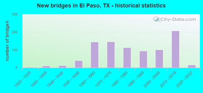
- New bridges - historical statistics
- 11910-1919
- 41920-1929
- 101930-1939
- 121940-1949
- 401950-1959
- 1441960-1969
- 1461970-1979
- 1131980-1989
- 941990-1999
- 1012000-2009
- 2072010-2019
- 162020-2022
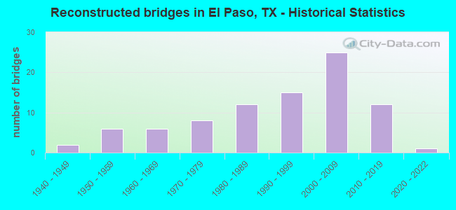
- Reconstructed bridges - Historical Statistics
- 21940-1949
- 61950-1959
- 61960-1969
- 81970-1979
- 121980-1989
- 151990-1999
- 252000-2009
- 122010-2019
- 12020-2022
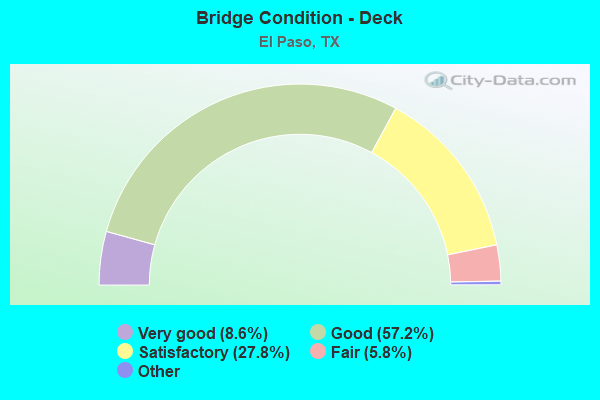
- Bridge Condition - Deck
- 8.6%Excellent
- 57.2%Very good
- 27.8%Good
- 5.8%Satisfactory
- 0.6%Fair
- 0.2%Poor
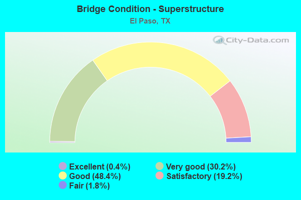
- Bridge Condition - Superstructure
- 0.4%Excellent
- 30.2%Very good
- 48.4%Good
- 19.2%Satisfactory
- 1.8%Fair
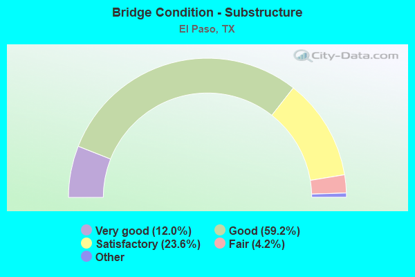
- Bridge Condition - Substructure
- 12.0%Excellent
- 59.2%Very good
- 23.6%Good
- 4.2%Satisfactory
- 1.0%Fair
- 0.6%Poor
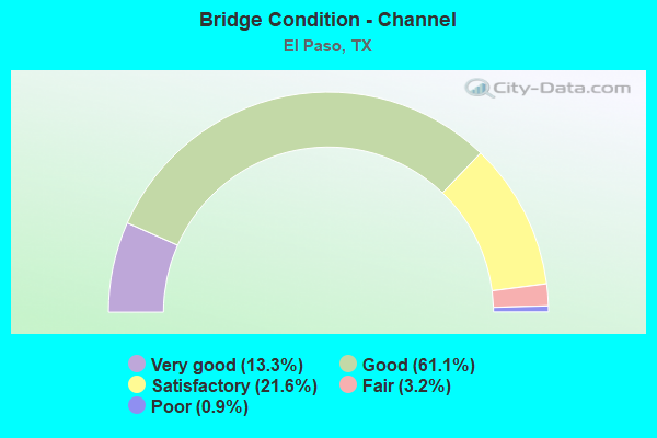
- Bridge Condition - Channel
- 13.3%Very good
- 61.1%Good
- 21.6%Satisfactory
- 3.2%Fair
- 0.9%Poor
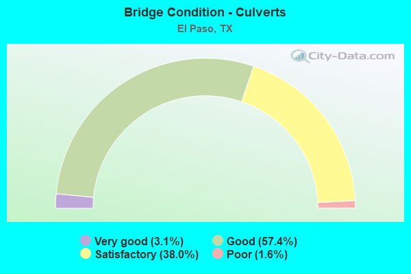
- Bridge Condition - Culverts
- 3.1%Very good
- 57.4%Good
- 38.0%Satisfactory
- 1.6%Poor
Find on map >> Show street view
Structure Number: 240720212102187, Location: 0.75 MI W OF SH 20(MESA) (Lat: 31.759858, Lng: -106.502414), Route carried "on" structure: City street , Year Built: 1968, Status: Open, Structure Length: 5.64m (18.50ft), Average Daily Traffic: 4,526 (year 2007), Average Future Daily Traffic: 64,638 (year 2027), Design Load: H 20, Features Intersected: IH 10, Facility Carried by Structure: PORFIRIO DIAZ ST
Minimum Vertical Clearance: 30+ m (98+ ft), Kilometerpoint: 0.531, Lanes on structure: 2, Lanes under structure: 8, Base Highway Network: Yes, Owner: State Highway Agency, Approaching Roadway Width: 5.5m (18.0ft), Material/Design: Steel continuous, Design/Construction: Stringer/Multi-beam, Number Of Spans In Main Unit: 2, Length of Maximum Span: 29.6m (97.1ft), Curb-To-Curb Width: 10.1m (33.1ft), Out-to-Out Width: 10.6m (34.8ft)
Condition: Deck: Satisfactory, Superstructure: Good, Substructure: Satisfactory, Operating Rating: 42.6 metric tons, Method Used To Determine Operating Rating: Load Factor (LF), Inventory Rating: 25.4 metric tons, Method Used To Determine Inventory Rating: Load Factor (LF), Structural Evaluation: Equal to present minimum criteria, Deck Geometry: Meets minimum limits, Underclear: Equal to present minimum criteria, Approach Roadway Alignment: Equal to present desirable criteria, Designated Inspection Frequency: Every 24 months, Inspection Date: August 2021, Deck Structure Type: Concrete Cast-file-Place, Wearing Surface/Protective System: Wearing Surface: Bituminous
Find on map >> Show street view
Structure Number: 240720212102188, Location: 0.45 MI SW OF SH20 (MESA) (Lat: 31.758919, Lng: -106.496956), Route carried "on" structure: Interstate 10, Year Built: 1968, Status: Open, Structure Length: 5.03m (16.50ft), Average Daily Traffic: 65,930 (year 2013), Truck Traffic: 9%, Average Future Daily Traffic: 92,300 (year 2033), Design Load: HS 20, Features Intersected: FRANKLIN AVE
Minimum Vertical Clearance: 30+ m (98+ ft), Kilometerpoint: 30.515, Lanes on structure: 4, Lanes under structure: 2, Base Highway Network: Yes, Owner: State Highway Agency, Approaching Roadway Width: 21.0m (68.9ft), Skew: 9 degrees, Material/Design: Prestressed concrete, Design/Construction: Stringer/Multi-beam, Number Of Spans In Main Unit: 3, Length of Maximum Span: 19.8m (65.0ft), Curb-To-Curb Width: 21.0m (68.9ft), Out-to-Out Width: 21.6m (70.9ft)
Condition: Deck: Good, Superstructure: Satisfactory, Substructure: Satisfactory, Operating Rating: 68.0 metric tons, Method Used To Determine Operating Rating: Load Factor (LF), Inventory Rating: 36.3 metric tons, Method Used To Determine Inventory Rating: Load Factor (LF), Structural Evaluation: Equal to present minimum criteria, Deck Geometry: Better than present minimum criteria, Underclear: Meets minimum limits, Approach Roadway Alignment: Equal to present desirable criteria, Length Of Structure Improvement: 5.03m (16.50ft), Designated Inspection Frequency: Every 24 months, Inspection Date: July 2021, Bridge Improvement Cost: $452,000, Roadway Improvement Cost: $113,000, Total Project Cost: $565,000, Deck Structure Type: Concrete Cast-file-Place
Find on map >> Show street view
Structure Number: 240720212102189, Location: 0.25 MI SW OF SH20 (MESA) (Lat: 31.760378, Lng: -106.493983), Route carried "on" structure: City street , Year Built: 1968, Status: Open, Structure Length: 10.82m (35.50ft), Average Daily Traffic: 4,970 (year 2009), Average Future Daily Traffic: 7,546 (year 2031), Design Load: H 20, Features Intersected: IH 10, Facility Carried by Structure: PROSPECT ST
Minimum Vertical Clearance: 30+ m (98+ ft), Kilometerpoint: 0.966, Lanes on structure: 2, Lanes under structure: 11, Owner: State Highway Agency, Approaching Roadway Width: 15.2m (49.9ft), Skew: 3 degrees, Material/Design: Steel continuous, Design/Construction: Stringer/Multi-beam, Number Of Spans In Main Unit: 3, Number Of Approach Spans: 2, Length of Maximum Span: 27.4m (89.9ft), Curb or Sidewalk Widths: Left: 1.5m (4.9ft), Right: 1.5m (4.9ft), Curb-To-Curb Width: 15.2m (49.9ft), Out-to-Out Width: 18.8m (61.7ft)
Condition: Deck: Satisfactory, Superstructure: Satisfactory, Substructure: Satisfactory, Operating Rating: 49.9 metric tons, Method Used To Determine Operating Rating: Load Factor (LF), Inventory Rating: 29.9 metric tons, Method Used To Determine Inventory Rating: Load Factor (LF), Structural Evaluation: Equal to present minimum criteria, Deck Geometry: Superior to present desirable criteria, Underclear: Equal to present minimum criteria, Approach Roadway Alignment: Equal to present desirable criteria, Designated Inspection Frequency: Every 24 months, Inspection Date: July 2021, Deck Structure Type: Concrete Cast-file-Place, Wearing Surface/Protective System: Wearing Surface: Bituminous
Find on map >> Show street view
Structure Number: 24072021210219, Location: 1.10 MI OF SH 20(MESA) (Lat: 31.763503, Lng: -106.506564), Route carried "on" structure: Interstate 10, Year Built: 1968, Status: Open, Structure Length: 0.61m (2.00ft), Average Daily Traffic: 131,860 (year 2013), Truck Traffic: 9%, Average Future Daily Traffic: 184,610 (year 2033), Features Intersected: HART MILL ARROYO
Minimum Vertical Clearance: 30+ m (98+ ft), Kilometerpoint: 29.411, Lanes on structure: 10, Base Highway Network: Yes, Owner: State Highway Agency, Approaching Roadway Width: 63.4m (208.0ft), Skew: 31 degrees, Material/Design: Concrete, Design/Construction: Culvert, Number Of Spans In Main Unit: 1, Length of Maximum Span: 6.1m (20.0ft)
Condition: Channel: Poor, Culverts: Satisfactory, Operating Rating: 32.7 metric tons, Method Used To Determine Operating Rating: Field evaluation and documented engineering judgment, Inventory Rating: 24.5 metric tons, Method Used To Determine Inventory Rating: Field evaluation and documented engineering judgment, Structural Evaluation: Equal to present minimum criteria, Waterway Adequacy: Superior to present desirable criteria, Approach Roadway Alignment: Equal to present desirable criteria, Designated Inspection Frequency: Every 24 months, Inspection Date: August 2021
Find on map >> Show street view
Structure Number: 240720212102194, Location: 0.20 MI SW OF SH20 (MESA) (Lat: 31.760939, Lng: -106.493122), Route carried "on" structure: City street , Year Built: 1969, Status: Open, Structure Length: 4.63m (15.19ft), Average Daily Traffic: 9,320 (year 2009), Average Future Daily Traffic: 58,838 (year 2031), Design Load: H 20, Features Intersected: IH 10, Facility Carried by Structure: SANTA FE ST
Minimum Vertical Clearance: 30+ m (98+ ft), Kilometerpoint: 0.048, Lanes on structure: 4, Lanes under structure: 6, Owner: State Highway Agency, Approaching Roadway Width: 18.3m (60.0ft), Material/Design: Steel continuous, Design/Construction: Stringer/Multi-beam, Number Of Spans In Main Unit: 2, Length of Maximum Span: 23.2m (76.1ft), Curb or Sidewalk Widths: Left: 1.5m (4.9ft), Right: 1.5m (4.9ft), Curb-To-Curb Width: 18.3m (60.0ft), Out-to-Out Width: 21.9m (71.9ft)
Condition: Deck: Satisfactory, Superstructure: Satisfactory, Substructure: Satisfactory, Operating Rating: 60.8 metric tons, Method Used To Determine Operating Rating: Load Factor (LF), Inventory Rating: 36.3 metric tons, Method Used To Determine Inventory Rating: Load Factor (LF), Structural Evaluation: Equal to present minimum criteria, Deck Geometry: Somewhat better than minimum adequacy, Underclear: Equal to present minimum criteria, Approach Roadway Alignment: Equal to present desirable criteria, Designated Inspection Frequency: Every 24 months, Inspection Date: July 2021, Deck Structure Type: Concrete Cast-file-Place, Wearing Surface/Protective System: Wearing Surface: Bituminous
Find on map >> Show street view
Structure Number: 240720212102195, Location: 0.15 MI SW OF SH20 (MESA) (Lat: 31.761508, Lng: -106.492292), Route carried "on" structure: City street , Year Built: 1969, Status: Open, Structure Length: 4.63m (15.19ft), Average Daily Traffic: 6,490 (year 2009), Average Future Daily Traffic: 58,838 (year 2031), Design Load: H 20, Features Intersected: IH 10, Facility Carried by Structure: EL PASO ST
Minimum Vertical Clearance: 30+ m (98+ ft), Kilometerpoint: 1.175, Lanes on structure: 2, Lanes under structure: 6, Owner: State Highway Agency, Approaching Roadway Width: 15.2m (49.9ft), Material/Design: Steel continuous, Design/Construction: Stringer/Multi-beam, Number Of Spans In Main Unit: 2, Length of Maximum Span: 23.2m (76.1ft), Curb or Sidewalk Widths: Left: 1.5m (4.9ft), Right: 1.5m (4.9ft), Curb-To-Curb Width: 15.2m (49.9ft), Out-to-Out Width: 18.8m (61.7ft)
Condition: Deck: Good, Superstructure: Very good, Substructure: Satisfactory, Operating Rating: 68.0 metric tons, Method Used To Determine Operating Rating: Load Factor (LF), Inventory Rating: 40.8 metric tons, Method Used To Determine Inventory Rating: Load Factor (LF), Structural Evaluation: Equal to present minimum criteria, Deck Geometry: Superior to present desirable criteria, Underclear: Equal to present minimum criteria, Approach Roadway Alignment: Equal to present desirable criteria, Designated Inspection Frequency: Every 24 months, Inspection Date: July 2021, Deck Structure Type: Concrete Cast-file-Place, Wearing Surface/Protective System: Wearing Surface: Bituminous
Find on map >> Show street view
Structure Number: 240720212102196, Location: 0.07 MI SW OF SH20 (MESA) (Lat: 31.762097, Lng: -106.491453), Route carried "on" structure: City street , Year Built: 1969, Status: Open, Structure Length: 4.63m (15.19ft), Average Daily Traffic: 6,910 (year 2013), Average Future Daily Traffic: 58,838 (year 2030), Design Load: H 20, Features Intersected: IH 10, Facility Carried by Structure: OREGON ST
Minimum Vertical Clearance: 30+ m (98+ ft), Kilometerpoint: 2.108, Lanes on structure: 3, Lanes under structure: 6, Owner: State Highway Agency, Approaching Roadway Width: 15.2m (49.9ft), Material/Design: Steel continuous, Design/Construction: Stringer/Multi-beam, Number Of Spans In Main Unit: 2, Length of Maximum Span: 23.2m (76.1ft), Curb or Sidewalk Widths: Left: 1.5m (4.9ft), Right: 1.5m (4.9ft), Curb-To-Curb Width: 15.2m (49.9ft), Out-to-Out Width: 18.8m (61.7ft)
Condition: Deck: Satisfactory, Superstructure: Very good, Substructure: Good, Operating Rating: 62.6 metric tons, Method Used To Determine Operating Rating: Load Factor (LF), Inventory Rating: 37.2 metric tons, Method Used To Determine Inventory Rating: Load Factor (LF), Structural Evaluation: Better than present minimum criteria, Deck Geometry: Equal to present minimum criteria, Underclear: Equal to present minimum criteria, Approach Roadway Alignment: Equal to present desirable criteria, Designated Inspection Frequency: Every 24 months, Inspection Date: July 2021, Deck Structure Type: Concrete Cast-file-Place
Find on map >> Show street view
Structure Number: 240720212102197, Location: 3.15 MI W OF US 54 (Lat: 31.762647, Lng: -106.490553), Route carried "on" structure: State highway 20, Year Built: 1969, Status: Open, Structure Length: 4.63m (15.19ft), Average Daily Traffic: 33,770 (year 2013), Truck Traffic: 6%, Average Future Daily Traffic: 47,270 (year 2033), Design Load: H 20, Features Intersected: IH 10
Minimum Vertical Clearance: 30+ m (98+ ft), Kilometerpoint: 1.959, Lanes on structure: 5, Lanes under structure: 6, Owner: State Highway Agency, Approaching Roadway Width: 18.3m (60.0ft), Material/Design: Steel continuous, Design/Construction: Stringer/Multi-beam, Number Of Spans In Main Unit: 2, Length of Maximum Span: 23.2m (76.1ft), Curb or Sidewalk Widths: Left: 1.5m (4.9ft), Right: 1.5m (4.9ft), Curb-To-Curb Width: 18.3m (60.0ft), Out-to-Out Width: 21.9m (71.9ft)
Condition: Deck: Satisfactory, Superstructure: Very good, Substructure: Good, Operating Rating: 62.6 metric tons, Method Used To Determine Operating Rating: Load Factor (LF), Inventory Rating: 37.2 metric tons, Method Used To Determine Inventory Rating: Load Factor (LF), Structural Evaluation: Better than present minimum criteria, Deck Geometry: High priority of replacement, Underclear: Equal to present minimum criteria, Approach Roadway Alignment: Equal to present desirable criteria, Length Of Structure Improvement: 4.63m (15.19ft), Designated Inspection Frequency: Every 24 months, Inspection Date: July 2021, Bridge Improvement Cost: $18,000, Roadway Improvement Cost: $5,000, Total Project Cost: $23,000, Deck Structure Type: Concrete Cast-file-Place
Find on map >> Show street view
Structure Number: 240720212102198, Location: 0.05 MI NW OF SH20 (MESA) (Lat: 31.763158, Lng: -106.489753), Route carried "on" structure: City street , Year Built: 1969, Status: Open, Structure Length: 4.63m (15.19ft), Average Daily Traffic: 7,067 (year 2013), Average Future Daily Traffic: 9,620 (year 2030), Design Load: H 20, Features Intersected: IH 10, Facility Carried by Structure: STANTON ST
Minimum Vertical Clearance: 30+ m (98+ ft), Kilometerpoint: 5.858, Lanes on structure: 3, Lanes under structure: 6, Owner: State Highway Agency, Approaching Roadway Width: 15.2m (49.9ft), Material/Design: Steel continuous, Design/Construction: Stringer/Multi-beam, Number Of Spans In Main Unit: 2, Length of Maximum Span: 23.2m (76.1ft), Curb or Sidewalk Widths: Left: 1.5m (4.9ft), Right: 1.5m (4.9ft), Curb-To-Curb Width: 15.2m (49.9ft), Out-to-Out Width: 18.8m (61.7ft)
Condition: Deck: Satisfactory, Superstructure: Good, Substructure: Good, Operating Rating: 68.0 metric tons, Method Used To Determine Operating Rating: Load Factor (LF), Inventory Rating: 40.8 metric tons, Method Used To Determine Inventory Rating: Load Factor (LF), Structural Evaluation: Better than present minimum criteria, Deck Geometry: Equal to present minimum criteria, Underclear: Somewhat better than minimum adequacy, Approach Roadway Alignment: Equal to present desirable criteria, Designated Inspection Frequency: Every 24 months, Inspection Date: July 2021, Deck Structure Type: Concrete Cast-file-Place
Find on map >> Show street view
Structure Number: 240720212102199, Location: 0.13 MI NW OF SH20 (MESA) (Lat: 31.763619, Lng: -106.488853), Route carried "on" structure: City street , Year Built: 1969, Status: Open, Structure Length: 5.85m (19.19ft), Average Daily Traffic: 20,670 (year 2013), Average Future Daily Traffic: 32,064 (year 2030), Design Load: H 20, Features Intersected: IH 10, Facility Carried by Structure: KANSAS ST
Minimum Vertical Clearance: 30+ m (98+ ft), Kilometerpoint: 2.124, Lanes on structure: 4, Lanes under structure: 6, Owner: State Highway Agency, Approaching Roadway Width: 15.2m (49.9ft), Skew: 1 degrees, Material/Design: Steel continuous, Design/Construction: Stringer/Multi-beam, Number Of Spans In Main Unit: 2, Number Of Approach Spans: 1, Length of Maximum Span: 23.2m (76.1ft), Curb or Sidewalk Widths: Left: 1.5m (4.9ft), Right: 1.5m (4.9ft), Curb-To-Curb Width: 15.2m (49.9ft), Out-to-Out Width: 18.8m (61.7ft)
Condition: Deck: Satisfactory, Superstructure: Very good, Substructure: Satisfactory, Operating Rating: 68.0 metric tons, Method Used To Determine Operating Rating: Load Factor (LF), Inventory Rating: 40.8 metric tons, Method Used To Determine Inventory Rating: Load Factor (LF), Structural Evaluation: Equal to present minimum criteria, Deck Geometry: High priority of corrective action, Underclear: Somewhat better than minimum adequacy, Approach Roadway Alignment: Equal to present desirable criteria, Length Of Structure Improvement: 5.85m (19.19ft), Designated Inspection Frequency: Every 24 months, Inspection Date: July 2021, Bridge Improvement Cost: $19,000, Roadway Improvement Cost: $5,000, Total Project Cost: $24,000, Deck Structure Type: Concrete Cast-file-Place
Find on map >> Show street view
Structure Number: 2407202121022, Location: 0.4 MI W OF US 62 (Lat: 31.777069, Lng: -106.428531), Route carried "on" structure: Ramp Interstate 10, Year Built: 1967, Status: Open, Structure Length: 8.41m (27.59ft), Average Daily Traffic: 18,520 (year 2013), Truck Traffic: 6%, Average Future Daily Traffic: 25,930 (year 2033), Design Load: HS 20, Features Intersected: IH 10 EB OFF-RP
Minimum Vertical Clearance: 30+ m (98+ ft), Kilometerpoint: 39.060, Lanes on structure: 1, Lanes under structure: 1, Owner: State Highway Agency, Approaching Roadway Width: 5.8m (19.0ft), Skew: 9 degrees, Material/Design: Steel continuous, Design/Construction: Stringer/Multi-beam, Number Of Spans In Main Unit: 4, Length of Maximum Span: 24.7m (81.0ft), Curb-To-Curb Width: 5.8m (19.0ft), Out-to-Out Width: 6.4m (21.0ft)
Condition: Deck: Fair, Superstructure: Satisfactory, Substructure: Satisfactory, Operating Rating: 39.9 metric tons, Method Used To Determine Operating Rating: Load Factor (LF), Inventory Rating: 23.6 metric tons, Method Used To Determine Inventory Rating: Load Factor (LF), Structural Evaluation: Somewhat better than minimum adequacy, Deck Geometry: Meets minimum limits, Underclear: High priority of corrective action, Approach Roadway Alignment: Equal to present desirable criteria, Designated Inspection Frequency: Every 24 months, Critical Feature Inspection Frequency: Every 24 months, Inspection Date: July 2021, Critical Feature Inspection Date: Febuary 2021, Deck Structure Type: Concrete Cast-file-Place
Find on map >> Show street view
Structure Number: 240720212102204, Location: 3.6 MI S OF SH 20 (Lat: 31.808542, Lng: -106.525689), Route carried "on" structure: Interstate 10, Year Built: 1969, Year Reconstructed: 2017, Status: Open, Structure Length: 4.42m (14.50ft), Average Daily Traffic: 70,802 (year 2019), Truck Traffic: 9%, Average Future Daily Traffic: 84,780 (year 2033), Design Load: HS 20, Features Intersected: HAUL RD DRAIN
Minimum Vertical Clearance: 30+ m (98+ ft), Kilometerpoint: 24.065, Lanes on structure: 5, Base Highway Network: Yes, Owner: State Highway Agency, Approaching Roadway Width: 24.7m (81.0ft), Skew: 9 degrees, Material/Design: Prestressed concrete, Design/Construction: Stringer/Multi-beam, Number Of Spans In Main Unit: 3, Length of Maximum Span: 15.2m (49.9ft), Curb-To-Curb Width: 24.7m (81.0ft), Out-to-Out Width: 25.3m (83.0ft)
Condition: Deck: Good, Superstructure: Good, Substructure: Satisfactory, Channel: Satisfactory, Operating Rating: 66.2 metric tons, Method Used To Determine Operating Rating: Load Factor (LF), Inventory Rating: 36.3 metric tons, Method Used To Determine Inventory Rating: Load Factor (LF), Structural Evaluation: Equal to present minimum criteria, Deck Geometry: Better than present minimum criteria, Waterway Adequacy: Superior to present desirable criteria, Approach Roadway Alignment: Equal to present desirable criteria, Designated Inspection Frequency: Every 24 months, Inspection Date: August 2021, Deck Structure Type: Concrete Cast-file-Place
Find on map >> Show street view
Structure Number: 240720212102205, Location: 4.1 MI S OF SH 20 (Lat: 31.803128, Lng: -106.521114), Route carried "on" structure: Interstate 10, Year Built: 1969, Year Reconstructed: 2017, Status: Open, Structure Length: 3.66m (12.01ft), Average Daily Traffic: 70,802 (year 2019), Truck Traffic: 9%, Average Future Daily Traffic: 84,780 (year 2033), Design Load: HS 20, Features Intersected: DRAIN
Minimum Vertical Clearance: 30+ m (98+ ft), Kilometerpoint: 24.821, Lanes on structure: 4, Base Highway Network: Yes, Owner: State Highway Agency, Approaching Roadway Width: 21.0m (68.9ft), Material/Design: Prestressed concrete, Design/Construction: Stringer/Multi-beam, Number Of Spans In Main Unit: 3, Length of Maximum Span: 12.2m (40.0ft), Curb-To-Curb Width: 21.0m (68.9ft), Out-to-Out Width: 21.6m (70.9ft)
Condition: Deck: Good, Superstructure: Good, Substructure: Good, Channel: Satisfactory, Operating Rating: 68.0 metric tons, Method Used To Determine Operating Rating: Load Factor (LF), Inventory Rating: 40.8 metric tons, Method Used To Determine Inventory Rating: Load Factor (LF), Structural Evaluation: Better than present minimum criteria, Deck Geometry: Better than present minimum criteria, Waterway Adequacy: Superior to present desirable criteria, Approach Roadway Alignment: Equal to present desirable criteria, Designated Inspection Frequency: Every 24 months, Inspection Date: August 2021, Deck Structure Type: Concrete Cast-file-Place
Find on map >> Show street view
Structure Number: 240720212102206, Location: 0.4 MI N OF EXEC BLVD (Lat: 31.799583, Lng: -106.520064), Route carried "on" structure: Interstate 10, Year Built: 1969, Status: Open, Structure Length: 1.52m (4.99ft), Average Daily Traffic: 117,480 (year 2020), Truck Traffic: 9%, Average Future Daily Traffic: 169,560 (year 2033), Design Load: HS 20, Features Intersected: DRAIN
Minimum Vertical Clearance: 30+ m (98+ ft), Kilometerpoint: 25.191, Lanes on structure: 6, Base Highway Network: Yes, Owner: State Highway Agency, Approaching Roadway Width: 35.1m (115.2ft), Skew: 33 degrees, Material/Design: Concrete, Design/Construction: Culvert, Number Of Spans In Main Unit: 5, Length of Maximum Span: 2.4m (7.9ft)
Condition: Channel: Poor, Culverts: Satisfactory, Operating Rating: 39.9 metric tons, Method Used To Determine Operating Rating: Load Factor (LF), Inventory Rating: 23.6 metric tons, Method Used To Determine Inventory Rating: Load Factor (LF), Structural Evaluation: Somewhat better than minimum adequacy, Waterway Adequacy: Superior to present desirable criteria, Approach Roadway Alignment: Equal to present desirable criteria, Designated Inspection Frequency: Every 24 months, Inspection Date: August 2021
Find on map >> Show street view
Structure Number: 240720212102207, Location: 2.65 MI SE OF SUNLAND PK (Lat: 31.792653, Lng: -106.520250), Route carried "on" structure: City street , Year Built: 1969, Status: Open, Structure Length: 10.36m (33.99ft), Average Daily Traffic: 40,185 (year 2013), Average Future Daily Traffic: 5,390 (year 2030), Design Load: HS 20, Features Intersected: IH 10, Facility Carried by Structure: EXECUTIVE CNTR EB
Minimum Vertical Clearance: 30+ m (98+ ft), Kilometerpoint: 25.935, Lanes on structure: 2, Lanes under structure: 8, Base Highway Network: Yes, Owner: State Highway Agency, Approaching Roadway Width: 10.1m (33.1ft), Skew: 4 degrees, Material/Design: Steel continuous, Design/Construction: Stringer/Multi-beam, Number Of Spans In Main Unit: 4, Length of Maximum Span: 29.3m (96.1ft), Curb or Sidewalk Widths: Left: 1.2m (3.9ft), Right: 1.2m (3.9ft), Curb-To-Curb Width: 13.0m (42.7ft), Out-to-Out Width: 15.2m (49.9ft)
Condition: Deck: Satisfactory, Superstructure: Satisfactory, Substructure: Good, Operating Rating: 49.9 metric tons, Method Used To Determine Operating Rating: Load Factor (LF), Inventory Rating: 29.9 metric tons, Method Used To Determine Inventory Rating: Load Factor (LF), Structural Evaluation: Equal to present minimum criteria, Deck Geometry: Superior to present desirable criteria, Underclear: High priority of corrective action, Approach Roadway Alignment: Equal to present desirable criteria, Designated Inspection Frequency: Every 24 months, Inspection Date: August 2021, Deck Structure Type: Concrete Cast-file-Place, Wearing Surface/Protective System: Wearing Surface: Bituminous
Find on map >> Show street view
Structure Number: 240720212102208, Location: 0.37 MI S OF EXEC BLVD (Lat: 31.787517, Lng: -106.519022), Route carried "on" structure: Interstate 10, Year Built: 1969, Status: Open, Structure Length: 0.67m (2.20ft), Average Daily Traffic: 131,725 (year 2020), Truck Traffic: 9%, Average Future Daily Traffic: 183,650 (year 2033), Design Load: HS 20, Features Intersected: DET DAM DISCHARGE
Minimum Vertical Clearance: 30+ m (98+ ft), Kilometerpoint: 26.525, Lanes on structure: 14, Base Highway Network: Yes, Owner: State Highway Agency, Approaching Roadway Width: 74.1m (243.1ft), Skew: 30 degrees, Material/Design: Concrete, Design/Construction: Culvert, Number Of Spans In Main Unit: 3, Length of Maximum Span: 2.1m (6.9ft)
Condition: Channel: Good, Culverts: Satisfactory, Operating Rating: 39.9 metric tons, Method Used To Determine Operating Rating: Load Factor (LF), Inventory Rating: 23.6 metric tons, Method Used To Determine Inventory Rating: Load Factor (LF), Structural Evaluation: Somewhat better than minimum adequacy, Waterway Adequacy: Superior to present desirable criteria, Approach Roadway Alignment: Equal to present desirable criteria, Designated Inspection Frequency: Every 24 months, Inspection Date: August 2021
Find on map >> Show street view
Structure Number: 240720212102209, Location: 0.55 MI S OF EXEC BLVD (Lat: 31.785264, Lng: -106.518986), Route carried "on" structure: Other road , Year Built: 1969, Year Reconstructed: 2018, Status: Open, Structure Length: 9.36m (30.71ft), Average Daily Traffic: 10 (year 2011), Average Future Daily Traffic: 50 (year 2031), Design Load: Railroad, Features Intersected: IH 10 & LP 375, Facility Carried by Structure: ASARCO SLAG RD
Minimum Vertical Clearance: 4.72m (15.49ft), Kilometerpoint: 0.000, Lanes on structure: 2, Lanes under structure: 10, Owner: Private, Approaching Roadway Width: 8.8m (28.9ft), Material/Design: Steel continuous, Design/Construction: Stringer/Multi-beam, Number Of Spans In Main Unit: 5, Length of Maximum Span: 23.8m (78.1ft), Curb-To-Curb Width: 8.9m (29.2ft), Out-to-Out Width: 9.7m (31.8ft)
Condition: Deck: Satisfactory, Superstructure: Satisfactory, Substructure: Satisfactory, Operating Rating: 68.0 metric tons, Method Used To Determine Operating Rating: Load Factor (LF), Inventory Rating: 40.8 metric tons, Method Used To Determine Inventory Rating: Load Factor (LF), Structural Evaluation: Equal to present minimum criteria, Deck Geometry: Better than present minimum criteria, Underclear: Meets minimum limits, Approach Roadway Alignment: Equal to present desirable criteria, Designated Inspection Frequency: Every 24 months, Inspection Date: August 2021, Deck Structure Type: Concrete Cast-file-Place
Find on map >> Show street view
Structure Number: 240720212102221, Location: 0.5 MI W OF US 54 (Lat: 31.777772, Lng: -106.451358), Route carried "on" structure: Ramp Interstate 10, Year Built: 1973, Status: Open, Structure Length: 6.41m (21.03ft), Average Daily Traffic: 18,430 (year 2010), Truck Traffic: 7%, Average Future Daily Traffic: 25,800 (year 2030), Design Load: HS 20, Features Intersected: COPIA ST.
Minimum Vertical Clearance: 30+ m (98+ ft), Kilometerpoint: 36.703, Lanes on structure: 2, Lanes under structure: 5, Owner: State Highway Agency, Approaching Roadway Width: 12.2m (40.0ft), Material/Design: Prestressed concrete, Design/Construction: Stringer/Multi-beam, Number Of Spans In Main Unit: 2, Number Of Approach Spans: 2, Length of Maximum Span: 18.3m (60.0ft), Curb-To-Curb Width: 12.2m (40.0ft), Out-to-Out Width: 12.7m (41.7ft)
Condition: Deck: Good, Superstructure: Very good, Substructure: Good, Operating Rating: 54.4 metric tons, Method Used To Determine Operating Rating: Assigned rating based on Load Factor Design (LFD) reported in metric tons, Inventory Rating: 32.7 metric tons, Method Used To Determine Inventory Rating: Assigned rating based on Load Factor Design (LFD) reported in metric tons, Structural Evaluation: Better than present minimum criteria, Deck Geometry: Superior to present desirable criteria, Underclear: High priority of corrective action, Approach Roadway Alignment: Equal to present desirable criteria, Designated Inspection Frequency: Every 24 months, Inspection Date: March 2020, Deck Structure Type: Concrete Cast-file-Place
Find on map >> Show street view
Structure Number: 240720212102222, Location: JCT IH 10 & US 54 (Lat: 31.777644, Lng: -106.449706), Route carried "on" structure: Ramp Interstate 10, Year Built: 1973, Status: Not yet open, Structure Length: 112.08m (367.72ft), Average Daily Traffic: 18,430 (year 2010), Truck Traffic: 7%, Average Future Daily Traffic: 30,920 (year 2030), Design Load: HS 20, Features Intersected: IH10 US54 RAMPS E D A
Minimum Vertical Clearance: 30+ m (98+ ft), Kilometerpoint: 36.843, Lanes on structure: 2, Lanes under structure: 23, Owner: State Highway Agency, Approaching Roadway Width: 12.2m (40.0ft), Skew: 9 degrees, Material/Design: Steel continuous, Design/Construction: Stringer/Multi-beam, Number Of Spans In Main Unit: 3, Number Of Approach Spans: 36, Length of Maximum Span: 59.1m (193.9ft), Curb-To-Curb Width: 12.2m (40.0ft), Out-to-Out Width: 12.7m (41.7ft)
Condition: Deck: Satisfactory, Superstructure: Good, Substructure: Satisfactory, Operating Rating: 44.4 metric tons, Method Used To Determine Operating Rating: No rating analysis performed, Inventory Rating: 32.7 metric tons, Method Used To Determine Inventory Rating: No rating analysis performed, Structural Evaluation: Equal to present minimum criteria, Deck Geometry: Superior to present desirable criteria, Underclear: High priority of corrective action, Approach Roadway Alignment: Somewhat better than minimum adequacy, Designated Inspection Frequency: Every 24 months, Critical Feature Inspection Frequency: Every 24 months, Inspection Date: March 2020, Critical Feature Inspection Date: Febuary 2021, Deck Structure Type: Concrete Cast-file-Place
Find on map >> Show street view
Structure Number: 240720212102224, Location: JCT I10 & US 54 (Lat: 31.778100, Lng: -106.438892), Route carried "on" structure: Ramp Interstate 10, Year Built: 1973, Status: Not yet open, Structure Length: 67.65m (221.95ft), Average Daily Traffic: 22,430 (year 2010), Truck Traffic: 6%, Average Future Daily Traffic: 31,890 (year 2030), Design Load: HS 20, Features Intersected: IH 10 & US 54
Minimum Vertical Clearance: 30+ m (98+ ft), Kilometerpoint: 37.889, Lanes on structure: 1, Lanes under structure: 13, Owner: State Highway Agency, Approaching Roadway Width: 9.1m (29.9ft), Skew: 9 degrees, Material/Design: Steel continuous, Design/Construction: Stringer/Multi-beam, Number Of Spans In Main Unit: 3, Number Of Approach Spans: 25, Length of Maximum Span: 59.1m (193.9ft), Curb-To-Curb Width: 9.1m (29.9ft), Out-to-Out Width: 9.7m (31.8ft)
Condition: Deck: Satisfactory, Superstructure: Very good, Substructure: Fair, Operating Rating: 44.4 metric tons, Method Used To Determine Operating Rating: No rating analysis performed, Inventory Rating: 32.7 metric tons, Method Used To Determine Inventory Rating: No rating analysis performed, Structural Evaluation: Somewhat better than minimum adequacy, Deck Geometry: Superior to present desirable criteria, Underclear: High priority of corrective action, Approach Roadway Alignment: Somewhat better than minimum adequacy, Designated Inspection Frequency: Every 24 months, Critical Feature Inspection Frequency: Every 24 months, Inspection Date: March 2020, Critical Feature Inspection Date: Febuary 2021, Deck Structure Type: Concrete Cast-file-Place
Find on map >> Show street view
Structure Number: 240720212102225, Location: JCT IH 10 & US 54 (Lat: 31.779222, Lng: -106.441536), Route carried "on" structure: Interstate 110, Year Built: 1973, Status: Not yet open, Structure Length: 77.78m (255.18ft), Average Daily Traffic: 33,450 (year 2013), Truck Traffic: 5%, Average Future Daily Traffic: 46,830 (year 2033), Design Load: HS 20, Features Intersected: I10 UPRR DURAZNO PD SH20, Facility Carried by Structure: SB US 54
Minimum Vertical Clearance: 4.88m (16.01ft), Kilometerpoint: 8.933, Lanes on structure: 2, Lanes under structure: 19, Owner: State Highway Agency, Approaching Roadway Width: 14.0m (45.9ft), Skew: 39 degrees, Material/Design: Prestressed concrete, Design/Construction: Stringer/Multi-beam, Number Of Spans In Main Unit: 3, Number Of Approach Spans: 30, Length of Maximum Span: 35.7m (117.1ft), Curb-To-Curb Width: 13.7m (44.9ft), Out-to-Out Width: 14.3m (46.9ft)
Condition: Deck: Satisfactory, Superstructure: Good, Substructure: Good, Operating Rating: 44.4 metric tons, Method Used To Determine Operating Rating: No rating analysis performed, Inventory Rating: 32.7 metric tons, Method Used To Determine Inventory Rating: No rating analysis performed, Structural Evaluation: Better than present minimum criteria, Deck Geometry: Somewhat better than minimum adequacy, Underclear: Meets minimum limits, Approach Roadway Alignment: Equal to present desirable criteria, Designated Inspection Frequency: Every 24 months, Inspection Date: March 2020, Deck Structure Type: Concrete Cast-file-Place
Find on map >> Show street view
Structure Number: 240720212102226, Location: JCT I10 & US 54 (Lat: 31.779422, Lng: -106.441947), Route carried "on" structure: US 54, Year Built: 1973, Status: Not yet open, Structure Length: 38.08m (124.93ft), Average Daily Traffic: 47,620 (year 2010), Truck Traffic: 8%, Average Future Daily Traffic: 66,670 (year 2030), Design Load: HS 20, Features Intersected: IH 10 & US 54
Minimum Vertical Clearance: 5.69m (18.67ft), Kilometerpoint: 9.772, Lanes on structure: 2, Lanes under structure: 16, Owner: State Highway Agency, Approaching Roadway Width: 12.2m (40.0ft), Skew: 9 degrees, Material/Design: Prestressed concrete, Design/Construction: Stringer/Multi-beam, Number Of Spans In Main Unit: 5, Number Of Approach Spans: 9, Length of Maximum Span: 39.6m (129.9ft), Curb-To-Curb Width: 12.2m (40.0ft), Out-to-Out Width: 12.7m (41.7ft)
Condition: Deck: Satisfactory, Superstructure: Good, Substructure: Good, Operating Rating: 44.4 metric tons, Method Used To Determine Operating Rating: No rating analysis performed, Inventory Rating: 32.7 metric tons, Method Used To Determine Inventory Rating: No rating analysis performed, Structural Evaluation: Better than present minimum criteria, Deck Geometry: Better than present minimum criteria, Underclear: Better than present minimum criteria, Approach Roadway Alignment: Somewhat better than minimum adequacy, Designated Inspection Frequency: Every 24 months, Inspection Date: March 2020, Deck Structure Type: Concrete Cast-file-Place
Find on map >> Show street view
Structure Number: 240720212102227, Location: JCT I10 & US 54 (Lat: 31.778039, Lng: -106.435519), Route carried "on" structure: Ramp Interstate 10, Year Built: 1973, Status: Open, Structure Length: 58.22m (191.01ft), Average Daily Traffic: 22,430 (year 2015), Truck Traffic: 6%, Average Future Daily Traffic: 31,890 (year 2035), Design Load: HS 20, Features Intersected: RAMP B TO US54 NB FR RD
Minimum Vertical Clearance: 5.23m (17.16ft), Kilometerpoint: 38.206, Lanes on structure: 2, Lanes under structure: 1, Owner: State Highway Agency, Approaching Roadway Width: 12.2m (40.0ft), Skew: 9 degrees, Material/Design: Prestressed concrete, Design/Construction: Stringer/Multi-beam, Number Of Spans In Main Unit: 25, Length of Maximum Span: 25.9m (85.0ft), Curb-To-Curb Width: 12.2m (40.0ft), Out-to-Out Width: 12.7m (41.7ft)
Condition: Deck: Satisfactory, Superstructure: Good, Substructure: Good, Operating Rating: 68.0 metric tons, Method Used To Determine Operating Rating: Load Factor (LF), Inventory Rating: 33.6 metric tons, Method Used To Determine Inventory Rating: Load Factor (LF), Structural Evaluation: Better than present minimum criteria, Deck Geometry: Equal to present minimum criteria, Underclear: High priority of corrective action, Approach Roadway Alignment: Meets minimum limits, Designated Inspection Frequency: Every 24 months, Inspection Date: March 2020, Deck Structure Type: Concrete Cast-file-Place
Find on map >> Show street view
Structure Number: 240720212102228, Location: 0.7 MI W JCT I10&US62 (Lat: 31.777792, Lng: -106.433750), Route carried "on" structure: Ramp Interstate 10, Year Built: 1973, Status: Open, Structure Length: 23.13m (75.89ft), Average Daily Traffic: 18,520 (year 2013), Truck Traffic: 6%, Average Future Daily Traffic: 25,930 (year 2033), Design Load: HS 20, Features Intersected: US 54 ON-RAMP (RAMP A)
Minimum Vertical Clearance: 30+ m (98+ ft), Kilometerpoint: 38.021, Lanes on structure: 1, Lanes under structure: 2, Owner: State Highway Agency, Approaching Roadway Width: 9.1m (29.9ft), Material/Design: Prestressed concrete, Design/Construction: Stringer/Multi-beam, Number Of Spans In Main Unit: 3, Number Of Approach Spans: 7, Length of Maximum Span: 28.0m (91.9ft), Curb-To-Curb Width: 9.1m (29.9ft), Out-to-Out Width: 9.7m (31.8ft)
Condition: Deck: Good, Superstructure: Good, Substructure: Satisfactory, Channel: Satisfactory, Operating Rating: 68.0 metric tons, Method Used To Determine Operating Rating: Load Factor (LF), Inventory Rating: 34.5 metric tons, Method Used To Determine Inventory Rating: Load Factor (LF), Structural Evaluation: Equal to present minimum criteria, Deck Geometry: Superior to present desirable criteria, Underclear: High priority of corrective action, Waterway Adequacy: Superior to present desirable criteria, Approach Roadway Alignment: Equal to present desirable criteria, Length Of Structure Improvement: 23.13m (75.89ft), Designated Inspection Frequency: Every 24 months, Critical Feature Inspection Frequency: Every 24 months, Inspection Date: March 2020, Critical Feature Inspection Date: Febuary 2021, Bridge Improvement Cost: $46,000, Roadway Improvement Cost: $12,000, Total Project Cost: $58,000, Deck Structure Type: Concrete Cast-file-Place
Find on map >> Show street view
Structure Number: 240720212102229, Location: 0.19 MI NE OF SH20 (MESA) (Lat: 31.763939, Lng: -106.487764), Route carried "on" structure: City street , Year Built: 1968, Status: Open, Structure Length: 8.72m (28.61ft), Average Daily Traffic: 17,641 (year 2013), Truck Traffic: 1%, Average Future Daily Traffic: 32,064 (year 2030), Design Load: HS 20, Features Intersected: IH 10, Facility Carried by Structure: CAMPBELL ST
Minimum Vertical Clearance: 30+ m (98+ ft), Kilometerpoint: 2.334, Lanes on structure: 3, Lanes under structure: 10, Owner: State Highway Agency, Approaching Roadway Width: 15.2m (49.9ft), Skew: 2 degrees, Material/Design: Steel continuous, Design/Construction: Stringer/Multi-beam, Number Of Spans In Main Unit: 2, Number Of Approach Spans: 3, Length of Maximum Span: 25.0m (82.0ft), Curb or Sidewalk Widths: Left: 1.5m (4.9ft), Right: 1.5m (4.9ft), Curb-To-Curb Width: 15.2m (49.9ft), Out-to-Out Width: 18.8m (61.7ft)
Condition: Deck: Satisfactory, Superstructure: Very good, Substructure: Satisfactory, Operating Rating: 37.2 metric tons, Method Used To Determine Operating Rating: Load Factor (LF), Inventory Rating: 21.8 metric tons, Method Used To Determine Inventory Rating: Load Factor (LF), Structural Evaluation: Somewhat better than minimum adequacy, Deck Geometry: Equal to present minimum criteria, Underclear: Equal to present minimum criteria, Approach Roadway Alignment: Equal to present desirable criteria, Designated Inspection Frequency: Every 24 months, Inspection Date: July 2021, Deck Structure Type: Concrete Cast-file-Place
Find on map >> Show street view
Structure Number: 240720212102247, Location: 1.95 MI W OF US 54 (Lat: 31.772019, Lng: -106.473103), Route carried "on" structure: Interstate 10, Year Built: 1968, Status: Open, Structure Length: 56.39m (185.01ft), Average Daily Traffic: 91,457 (year 2019), Truck Traffic: 9%, Average Future Daily Traffic: 122,780 (year 2033), Design Load: HS 20, Features Intersected: COTTON AVE & UPRR
Minimum Vertical Clearance: 30+ m (98+ ft), Kilometerpoint: 33.149, Lanes on structure: 5, Lanes under structure: 9, Base Highway Network: Yes, Owner: State Highway Agency, Approaching Roadway Width: 24.4m (80.1ft), Skew: 9 degrees, Material/Design: Steel, Design/Construction: Stringer/Multi-beam, Number Of Spans In Main Unit: 1, Number Of Approach Spans: 27, Length of Maximum Span: 29.0m (95.1ft), Curb-To-Curb Width: 24.4m (80.1ft), Out-to-Out Width: 24.7m (81.0ft)
Condition: Deck: Fair, Superstructure: Satisfactory, Substructure: Satisfactory, Operating Rating: 50.8 metric tons, Method Used To Determine Operating Rating: Load Factor (LF), Inventory Rating: 29.9 metric tons, Method Used To Determine Inventory Rating: Load Factor (LF), Structural Evaluation: Equal to present minimum criteria, Deck Geometry: Equal to present minimum criteria, Underclear: High priority of corrective action, Approach Roadway Alignment: Equal to present desirable criteria, Length Of Structure Improvement: 56.39m (185.01ft), Designated Inspection Frequency: Every 24 months, Inspection Date: May 2021, Deck Structure Type: Concrete Cast-file-Place
Find on map >> Show street view
Structure Number: 240720212102248, Location: JCT US-54 & IH-10 (Lat: 31.779069, Lng: -106.442372), Route carried "on" structure: Ramp US 54, Year Built: 1973, Status: Open, Structure Length: 18.17m (59.61ft), Average Daily Traffic: 47,620 (year 2010), Truck Traffic: 8%, Average Future Daily Traffic: 66,670 (year 2030), Design Load: HS 20, Features Intersected: WB IH 10 & DURAZNO POND
Minimum Vertical Clearance: 5.31m (17.42ft), Kilometerpoint: 9.558, Lanes on structure: 1, Lanes under structure: 5, Owner: State Highway Agency, Approaching Roadway Width: 9.1m (29.9ft), Skew: 9 degrees, Material/Design: Prestressed concrete, Design/Construction: Stringer/Multi-beam, Number Of Spans In Main Unit: 1, Number Of Approach Spans: 7, Length of Maximum Span: 31.0m (101.7ft), Curb-To-Curb Width: 9.1m (29.9ft), Out-to-Out Width: 9.7m (31.8ft)
Condition: Deck: Good, Superstructure: Good, Substructure: Very good, Operating Rating: 54.4 metric tons, Method Used To Determine Operating Rating: Assigned rating based on Load Factor Design (LFD) reported in metric tons, Inventory Rating: 32.7 metric tons, Method Used To Determine Inventory Rating: Assigned rating based on Load Factor Design (LFD) reported in metric tons, Structural Evaluation: Better than present minimum criteria, Deck Geometry: Meets minimum limits, Underclear: Equal to present minimum criteria, Approach Roadway Alignment: Equal to present desirable criteria, Designated Inspection Frequency: Every 24 months, Inspection Date: March 2020, Deck Structure Type: Concrete Cast-file-Place
Find on map >> Show street view
Structure Number: 240720212102254, Location: 3.9 MI W OF US 62 (Lat: 31.778406, Lng: -106.459636), Route carried "on" structure: Interstate 10, Year Built: 1968, Status: Open, Structure Length: 5.36m (17.59ft), Average Daily Traffic: 89,207 (year 2017), Truck Traffic: 6%, Average Future Daily Traffic: 122,840 (year 2033), Design Load: HS 20, Features Intersected: RAYNOR ST (NB)
Minimum Vertical Clearance: 30+ m (98+ ft), Kilometerpoint: 34.765, Lanes on structure: 6, Lanes under structure: 5, Base Highway Network: Yes, Owner: State Highway Agency, Approaching Roadway Width: 28.7m (94.2ft), Material/Design: Prestressed concrete, Design/Construction: Stringer/Multi-beam, Number Of Spans In Main Unit: 2, Number Of Approach Spans: 1, Length of Maximum Span: 20.7m (67.9ft), Curb-To-Curb Width: 28.4m (93.2ft), Out-to-Out Width: 28.7m (94.2ft)
Condition: Deck: Satisfactory, Superstructure: Good, Substructure: Satisfactory, Operating Rating: 59.0 metric tons, Method Used To Determine Operating Rating: Load Factor (LF), Inventory Rating: 34.5 metric tons, Method Used To Determine Inventory Rating: Load Factor (LF), Structural Evaluation: Equal to present minimum criteria, Deck Geometry: Better than present minimum criteria, Underclear: Somewhat better than minimum adequacy, Approach Roadway Alignment: Equal to present desirable criteria, Designated Inspection Frequency: Every 24 months, Inspection Date: July 2021, Deck Structure Type: Concrete Cast-file-Place
Find on map >> Show street view
Structure Number: 240720212102255, Location: 1.6 MI S OF SUNLAND PK (Lat: 31.808636, Lng: -106.525150), Route carried "on" structure: Interstate 10, Year Built: 1969, Year Reconstructed: 2017, Status: Open, Structure Length: 4.42m (14.50ft), Average Daily Traffic: 62,695 (year 2019), Truck Traffic: 9%, Average Future Daily Traffic: 84,780 (year 2033), Design Load: HS 20, Features Intersected: HAUL RD DRAIN
Minimum Vertical Clearance: 30+ m (98+ ft), Kilometerpoint: 24.065, Lanes on structure: 4, Base Highway Network: Yes, Owner: State Highway Agency, Approaching Roadway Width: 21.3m (69.9ft), Skew: 9 degrees, Material/Design: Prestressed concrete, Design/Construction: Stringer/Multi-beam, Number Of Spans In Main Unit: 3, Length of Maximum Span: 15.2m (49.9ft), Curb-To-Curb Width: 21.0m (68.9ft), Out-to-Out Width: 21.6m (70.9ft)
Condition: Deck: Good, Superstructure: Good, Substructure: Satisfactory, Channel: Satisfactory, Operating Rating: 66.2 metric tons, Method Used To Determine Operating Rating: Load Factor (LF), Inventory Rating: 36.3 metric tons, Method Used To Determine Inventory Rating: Load Factor (LF), Structural Evaluation: Equal to present minimum criteria, Deck Geometry: Better than present minimum criteria, Waterway Adequacy: Superior to present desirable criteria, Approach Roadway Alignment: Equal to present desirable criteria, Designated Inspection Frequency: Every 24 months, Inspection Date: August 2021, Deck Structure Type: Concrete Cast-file-Place
Find on map >> Show street view
Structure Number: 240720212102256, Location: 2.1 MI S OF SUNLAND PK (Lat: 31.803039, Lng: -106.520789), Route carried "on" structure: Interstate 10, Year Built: 1969, Status: Open, Structure Length: 3.66m (12.01ft), Average Daily Traffic: 62,695 (year 2019), Truck Traffic: 9%, Average Future Daily Traffic: 84,780 (year 2033), Design Load: HS 20, Features Intersected: DRAIN
Minimum Vertical Clearance: 30+ m (98+ ft), Kilometerpoint: 24.821, Lanes on structure: 4, Base Highway Network: Yes, Owner: State Highway Agency, Approaching Roadway Width: 21.0m (68.9ft), Material/Design: Prestressed concrete, Design/Construction: Stringer/Multi-beam, Number Of Spans In Main Unit: 3, Length of Maximum Span: 12.2m (40.0ft), Curb-To-Curb Width: 21.0m (68.9ft), Out-to-Out Width: 21.6m (70.9ft)
Condition: Deck: Good, Superstructure: Good, Substructure: Good, Channel: Satisfactory, Operating Rating: 68.0 metric tons, Method Used To Determine Operating Rating: Load Factor (LF), Inventory Rating: 40.8 metric tons, Method Used To Determine Inventory Rating: Load Factor (LF), Structural Evaluation: Better than present minimum criteria, Deck Geometry: Better than present minimum criteria, Waterway Adequacy: Superior to present desirable criteria, Approach Roadway Alignment: Equal to present desirable criteria, Designated Inspection Frequency: Every 24 months, Inspection Date: August 2021, Deck Structure Type: Concrete Cast-file-Place
Find on map >> Show street view
Structure Number: 240720212102262, Location: 0.75 MI S OF SH 20 (MESA) (Lat: 31.823733, Lng: -106.556736), Route carried "on" structure: Ramp Interstate 10, Year Built: 1988, Status: Open, Structure Length: 1.59m (5.22ft), Average Daily Traffic: 31,632 (year 2009), Average Future Daily Traffic: 57,690 (year 2028), Design Load: HS 20, Features Intersected: DIVERSION CHANNEL, Facility Carried by Structure: RESLER EXIT RAMP
Minimum Vertical Clearance: 30+ m (98+ ft), Kilometerpoint: 0.563, Lanes on structure: 2, Owner: State Highway Agency, Maintenance Responsibility: State Park, Forest, or Reservation Agency, Approaching Roadway Width: 10.7m (35.1ft), Skew: 6 degrees, Material/Design: Concrete, Design/Construction: Culvert, Number Of Spans In Main Unit: 2, Length of Maximum Span: 3.0m (9.8ft)
Condition: Channel: Good, Culverts: Good, Operating Rating: 39.9 metric tons, Method Used To Determine Operating Rating: Load Factor (LF), Inventory Rating: 23.6 metric tons, Method Used To Determine Inventory Rating: Load Factor (LF), Structural Evaluation: Somewhat better than minimum adequacy, Waterway Adequacy: Superior to present desirable criteria, Approach Roadway Alignment: Better than present minimum criteria, Designated Inspection Frequency: Every 24 months, Inspection Date: August 2021
Find on map >> Show street view
Structure Number: 240720212102278, Location: 3.0 MI W OF US 62 (Lat: 31.778397, Lng: -106.461256), Route carried "on" structure: Interstate 10, Year Built: 1968, Status: Open, Structure Length: 7.10m (23.29ft), Average Daily Traffic: 89,207 (year 2017), Truck Traffic: 4%, Average Future Daily Traffic: 106,375 (year 2030), Design Load: HS 20, Features Intersected: PIEDRAS ST
Minimum Vertical Clearance: 30+ m (98+ ft), Kilometerpoint: 34.496, Lanes on structure: 6, Lanes under structure: 6, Base Highway Network: Yes, Owner: State Highway Agency, Approaching Roadway Width: 28.7m (94.2ft), Material/Design: Steel continuous, Design/Construction: Stringer/Multi-beam, Number Of Spans In Main Unit: 2, Number Of Approach Spans: 1, Length of Maximum Span: 28.3m (92.8ft), Curb-To-Curb Width: 28.7m (94.2ft), Out-to-Out Width: 28.9m (94.8ft)
Condition: Deck: Fair, Superstructure: Good, Substructure: Good, Operating Rating: 56.2 metric tons, Method Used To Determine Operating Rating: Load Factor (LF), Inventory Rating: 33.6 metric tons, Method Used To Determine Inventory Rating: Load Factor (LF), Structural Evaluation: Better than present minimum criteria, Deck Geometry: Better than present minimum criteria, Underclear: Somewhat better than minimum adequacy, Approach Roadway Alignment: Equal to present desirable criteria, Designated Inspection Frequency: Every 24 months, Inspection Date: July 2021, Deck Structure Type: Concrete Cast-file-Place
Find on map >> Show street view
Structure Number: 240720212102279, Location: 5.70 MI W OF US 62 (Lat: 31.766158, Lng: -106.507772), Route carried "on" structure: Interstate 10, Year Built: 1968, Status: Open, Structure Length: 4.63m (15.19ft), Average Daily Traffic: 69,550 (year 2011), Truck Traffic: 9%, Average Future Daily Traffic: 110,770 (year 2031), Design Load: HS 20, Features Intersected: SCHUSTER ST
Minimum Vertical Clearance: 30+ m (98+ ft), Kilometerpoint: 29.071, Lanes on structure: 4, Lanes under structure: 3, Base Highway Network: Yes, Owner: State Highway Agency, Approaching Roadway Width: 21.3m (69.9ft), Material/Design: Steel continuous, Design/Construction: Stringer/Multi-beam, Number Of Spans In Main Unit: 2, Length of Maximum Span: 23.2m (76.1ft), Curb-To-Curb Width: 21.2m (69.6ft), Out-to-Out Width: 21.8m (71.5ft)
Condition: Deck: Fair, Superstructure: Good, Substructure: Satisfactory, Operating Rating: 46.3 metric tons, Method Used To Determine Operating Rating: Load Factor (LF), Inventory Rating: 27.2 metric tons, Method Used To Determine Inventory Rating: Load Factor (LF), Structural Evaluation: Equal to present minimum criteria, Deck Geometry: Better than present minimum criteria, Underclear: Meets minimum limits, Approach Roadway Alignment: Equal to present desirable criteria, Designated Inspection Frequency: Every 24 months, Inspection Date: August 2021, Deck Structure Type: Concrete Cast-file-Place
Find on map >> Show street view
Structure Number: 24072021210228, Location: 0.45 MI SW OF SH20 (MESA) (Lat: 31.759361, Lng: -106.496592), Route carried "on" structure: Interstate 10, Year Built: 1968, Status: Open, Structure Length: 5.03m (16.50ft), Average Daily Traffic: 71,010 (year 2011), Truck Traffic: 8%, Average Future Daily Traffic: 123,580 (year 2031), Design Load: HS 20, Features Intersected: FRANKLIN AVE
Minimum Vertical Clearance: 30+ m (98+ ft), Kilometerpoint: 30.541, Lanes on structure: 4, Lanes under structure: 2, Base Highway Network: Yes, Owner: State Highway Agency, Approaching Roadway Width: 21.0m (68.9ft), Skew: 9 degrees, Material/Design: Prestressed concrete, Design/Construction: Stringer/Multi-beam, Number Of Spans In Main Unit: 3, Length of Maximum Span: 19.8m (65.0ft), Curb-To-Curb Width: 21.0m (68.9ft), Out-to-Out Width: 21.6m (70.9ft)
Condition: Deck: Good, Superstructure: Satisfactory, Substructure: Good, Operating Rating: 68.0 metric tons, Method Used To Determine Operating Rating: Load Factor (LF), Inventory Rating: 36.3 metric tons, Method Used To Determine Inventory Rating: Load Factor (LF), Structural Evaluation: Equal to present minimum criteria, Deck Geometry: Better than present minimum criteria, Underclear: Meets minimum limits, Approach Roadway Alignment: Equal to present desirable criteria, Length Of Structure Improvement: 5.03m (16.50ft), Designated Inspection Frequency: Every 24 months, Inspection Date: July 2021, Bridge Improvement Cost: $452,000, Roadway Improvement Cost: $113,000, Total Project Cost: $565,000, Deck Structure Type: Concrete Cast-file-Place
Find on map >> Show street view
Structure Number: 240720212102281, Location: S OF COTTON AVE & IH10 EB (Lat: 31.770644, Lng: -106.473186), Route carried "on" structure: Ramp Interstate 10, Year Built: 2002, Status: Open, Structure Length: 29.20m (95.80ft), Average Daily Traffic: 18,440 (year 2009), Truck Traffic: 8%, Average Future Daily Traffic: 27,640 (year 2029), Design Load: HS 20, Features Intersected: UP RR YARD
Minimum Vertical Clearance: 30+ m (98+ ft), Kilometerpoint: 34.498, Lanes on structure: 1, Owner: State Highway Agency, Approaching Roadway Width: 7.9m (25.9ft), Skew: 9 degrees, Material/Design: Steel, Design/Construction: Stringer/Multi-beam, Number Of Spans In Main Unit: 1, Number Of Approach Spans: 7, Length of Maximum Span: 56.1m (184.1ft), Curb-To-Curb Width: 8.0m (26.2ft), Out-to-Out Width: 8.5m (27.9ft)
Condition: Deck: Good, Superstructure: Very good, Substructure: Good, Operating Rating: 49.0 metric tons, Method Used To Determine Operating Rating: Load Factor (LF), Inventory Rating: 29.0 metric tons, Method Used To Determine Inventory Rating: Load Factor (LF), Structural Evaluation: Better than present minimum criteria, Deck Geometry: Superior to present desirable criteria, Underclear: Somewhat better than minimum adequacy, Approach Roadway Alignment: Equal to present desirable criteria, Designated Inspection Frequency: Every 24 months, Inspection Date: May 2021, Deck Structure Type: Corrugated Steel
Find on map >> Show street view
Structure Number: 240720212102282, Location: 2.65 MI SE OF SUNLAND PK (Lat: 31.793614, Lng: -106.519464), Route carried "on" structure: City street , Year Built: 1969, Status: Open, Structure Length: 10.36m (33.99ft), Average Daily Traffic: 40,185 (year 2013), Average Future Daily Traffic: 5,390 (year 2030), Design Load: HS 20, Features Intersected: IH 10, Facility Carried by Structure: EXECUTIVE CNTR WB
Minimum Vertical Clearance: 30+ m (98+ ft), Kilometerpoint: 0.842, Lanes on structure: 2, Lanes under structure: 8, Base Highway Network: Yes, Owner: State Highway Agency, Approaching Roadway Width: 10.1m (33.1ft), Skew: 4 degrees, Material/Design: Steel continuous, Design/Construction: Stringer/Multi-beam, Number Of Spans In Main Unit: 4, Length of Maximum Span: 29.3m (96.1ft), Curb or Sidewalk Widths: Left: 1.2m (3.9ft), Right: 0.0m, Curb-To-Curb Width: 13.0m (42.7ft), Out-to-Out Width: 15.2m (49.9ft)
Condition: Deck: Satisfactory, Superstructure: Good, Substructure: Good, Operating Rating: 49.9 metric tons, Method Used To Determine Operating Rating: Load Factor (LF), Inventory Rating: 29.9 metric tons, Method Used To Determine Inventory Rating: Load Factor (LF), Structural Evaluation: Better than present minimum criteria, Deck Geometry: Superior to present desirable criteria, Underclear: High priority of corrective action, Approach Roadway Alignment: Equal to present desirable criteria, Designated Inspection Frequency: Every 24 months, Inspection Date: August 2021, Deck Structure Type: Concrete Cast-file-Place, Wearing Surface/Protective System: Wearing Surface: Bituminous
Find on map >> Show street view
Structure Number: 240720212102287, Location: JCT IH 10 & US 54 (Lat: 31.773122, Lng: -106.445167), Route carried "on" structure: Interstate 110, Year Built: 1973, Year Reconstructed: 2007, Status: Open, Structure Length: 77.78m (255.18ft), Average Daily Traffic: 46,300 (year 2010), Truck Traffic: 1%, Average Future Daily Traffic: 65,750 (year 2030), Design Load: HS 20, Features Intersected: I10 UPRR DURAZNO PDSH20, Facility Carried by Structure: NB US 54
Minimum Vertical Clearance: 4.88m (16.01ft), Kilometerpoint: 8.993, Lanes on structure: 2, Lanes under structure: 19, Owner: State Highway Agency, Approaching Roadway Width: 14.0m (45.9ft), Skew: 39 degrees, Material/Design: Prestressed concrete, Design/Construction: Stringer/Multi-beam, Number Of Spans In Main Unit: 3, Number Of Approach Spans: 30, Length of Maximum Span: 35.7m (117.1ft), Curb-To-Curb Width: 13.7m (44.9ft), Out-to-Out Width: 14.0m (45.9ft)
Condition: Deck: Satisfactory, Superstructure: Good, Substructure: Good, Operating Rating: 54.4 metric tons, Method Used To Determine Operating Rating: Assigned rating based on Load Factor Design (LFD) reported in metric tons, Inventory Rating: 32.7 metric tons, Method Used To Determine Inventory Rating: Assigned rating based on Load Factor Design (LFD) reported in metric tons, Structural Evaluation: Better than present minimum criteria, Deck Geometry: Somewhat better than minimum adequacy, Underclear: Equal to present minimum criteria, Approach Roadway Alignment: Equal to present desirable criteria, Length Of Structure Improvement: 77.79m (255.22ft), Designated Inspection Frequency: Every 24 months, Inspection Date: March 2020, Bridge Improvement Cost: $235,000, Roadway Improvement Cost: $59,000, Total Project Cost: $294,000, Deck Structure Type: Concrete Cast-file-Place
Find on map >> Show street view
Structure Number: 240720212102288, Location: 0.8 MI W OF N MESA ST (Lat: 31.766550, Lng: -106.507381), Route carried "on" structure: Ramp Interstate 10, Year Built: 2010, Status: Open, Structure Length: 3.66m (12.01ft), Average Daily Traffic: 11,700 (year 2010), Truck Traffic: 5%, Average Future Daily Traffic: 16,550 (year 2030), Design Load: HL 93, Features Intersected: SCHUSTER AVENUE
Minimum Vertical Clearance: 30+ m (98+ ft), Kilometerpoint: 29.071, Lanes on structure: 2, Lanes under structure: 4, Owner: State Highway Agency, Approaching Roadway Width: 9.8m (32.2ft), Skew: 1 degrees, Material/Design: Prestressed concrete, Design/Construction: Stringer/Multi-beam, Number Of Spans In Main Unit: 1, Length of Maximum Span: 36.6m (120.1ft), Curb-To-Curb Width: 9.4m (30.8ft), Out-to-Out Width: 10.4m (34.1ft)
Condition: Deck: Good, Superstructure: Very good, Substructure: Very good, Operating Rating: 54.4 metric tons, Method Used To Determine Operating Rating: Assigned ratings based on Load and Resistance Factor Design (LRFD) reported in metric tons, Inventory Rating: 32.7 metric tons, Method Used To Determine Inventory Rating: Assigned ratings based on Load and Resistance Factor Design (LRFD) reported in metric tons, Structural Evaluation: Equal to present desirable criteria, Deck Geometry: Somewhat better than minimum adequacy, Underclear: Meets minimum limits, Approach Roadway Alignment: Equal to present desirable criteria, Designated Inspection Frequency: Every 24 months, Inspection Date: March 2020, Deck Structure Type: Concrete Cast-file-Place
Find on map >> Show street view
Structure Number: 2407202121023, Location: SPUR 1966 AT IH 10 (Lat: 31.762561, Lng: -106.507506), Route carried "on" structure: State highway 1966, Year Built: 2014, Status: Open, Structure Length: 36.39m (119.39ft), Average Daily Traffic: 5,800 (year 2015), Average Future Daily Traffic: 9,200 (year 2035), Design Load: HL 93, Features Intersected: IH10 BNSF RR UP RR
Minimum Vertical Clearance: 30+ m (98+ ft), Kilometerpoint: 0.000, Lanes on structure: 4, Lanes under structure: 15, Owner: State Highway Agency, Approaching Roadway Width: 24.4m (80.1ft), Skew: 1 degrees, Material/Design: Prestressed concrete, Design/Construction: Stringer/Multi-beam, Number Of Spans In Main Unit: 10, Number Of Approach Spans: 2, Length of Maximum Span: 36.6m (120.1ft), Curb or Sidewalk Widths: Left: 0.0m, Right: 1.8m (5.9ft), Curb-To-Curb Width: 24.4m (80.1ft), Out-to-Out Width: 27.1m (88.9ft)
Condition: Deck: Good, Superstructure: Very good, Substructure: Good, Operating Rating: 54.4 metric tons, Method Used To Determine Operating Rating: Assigned ratings based on Load and Resistance Factor Design (LRFD) reported in metric tons, Inventory Rating: 32.7 metric tons, Method Used To Determine Inventory Rating: Assigned ratings based on Load and Resistance Factor Design (LRFD) reported in metric tons, Structural Evaluation: Better than present minimum criteria, Deck Geometry: Superior to present desirable criteria, Underclear: High priority of corrective action, Approach Roadway Alignment: Equal to present desirable criteria, Designated Inspection Frequency: Every 24 months, Inspection Date: May 2021, Deck Structure Type: Concrete Precast Panels
Find on map >> Show street view
Structure Number: 240720212102314, Location: 0.7 MI S OF SH 20 (Lat: 31.830150, Lng: -106.564069), Route carried "on" structure: Interstate 10, Year Built: 2019, Status: Open, Structure Length: 5.49m (18.01ft), Average Daily Traffic: 84,600 (year 2015), Truck Traffic: 10%, Average Future Daily Traffic: 151,000 (year 2035), Design Load: HL 93, Features Intersected: ARROYO 4
Minimum Vertical Clearance: 30+ m (98+ ft), Kilometerpoint: 19.182, Lanes on structure: 4, Owner: State Highway Agency, Approaching Roadway Width: 20.7m (67.9ft), Material/Design: Prestressed concrete, Design/Construction: Stringer/Multi-beam, Number Of Spans In Main Unit: 3, Length of Maximum Span: 18.3m (60.0ft), Curb-To-Curb Width: 20.7m (67.9ft), Out-to-Out Width: 27.1m (88.9ft)
Condition: Deck: Good, Superstructure: Very good, Substructure: Very good, Channel: Very good, Operating Rating: 54.4 metric tons, Method Used To Determine Operating Rating: Assigned ratings based on Load and Resistance Factor Design (LRFD) reported in metric tons, Inventory Rating: 32.7 metric tons, Method Used To Determine Inventory Rating: Assigned ratings based on Load and Resistance Factor Design (LRFD) reported in metric tons, Structural Evaluation: Equal to present desirable criteria, Deck Geometry: Equal to present minimum criteria, Waterway Adequacy: Superior to present desirable criteria, Approach Roadway Alignment: Equal to present desirable criteria, Designated Inspection Frequency: Every 24 months, Inspection Date: August 2021, Deck Structure Type: Concrete Cast-file-Place
Find on map >> Show street view
Structure Number: 240720212102315, Location: 0.7 MI S OF SH 20 (Lat: 31.830233, Lng: -106.564783), Route carried "on" structure: Interstate 10, Year Built: 2019, Status: Open, Structure Length: 5.49m (18.01ft), Average Daily Traffic: 84,600 (year 2015), Truck Traffic: 10%, Average Future Daily Traffic: 151,000 (year 2035), Design Load: HL 93, Features Intersected: ARROYO 4
Minimum Vertical Clearance: 30+ m (98+ ft), Kilometerpoint: 19.182, Lanes on structure: 4, Owner: State Highway Agency, Approaching Roadway Width: 20.7m (67.9ft), Material/Design: Prestressed concrete, Design/Construction: Stringer/Multi-beam, Number Of Spans In Main Unit: 3, Length of Maximum Span: 18.3m (60.0ft), Curb-To-Curb Width: 20.7m (67.9ft), Out-to-Out Width: 27.1m (88.9ft)
Condition: Deck: Good, Superstructure: Very good, Substructure: Good, Channel: Very good, Operating Rating: 54.4 metric tons, Method Used To Determine Operating Rating: Assigned ratings based on Load and Resistance Factor Design (LRFD) reported in metric tons, Inventory Rating: 32.7 metric tons, Method Used To Determine Inventory Rating: Assigned ratings based on Load and Resistance Factor Design (LRFD) reported in metric tons, Structural Evaluation: Better than present minimum criteria, Deck Geometry: Equal to present minimum criteria, Waterway Adequacy: Superior to present desirable criteria, Approach Roadway Alignment: Equal to present desirable criteria, Designated Inspection Frequency: Every 24 months, Inspection Date: August 2021, Deck Structure Type: Concrete Cast-file-Place