Bridge Statistics for El Paso, Texas (TX)
Condition, Traffic, Stress, Structural Evaluation, Project Costs
- National Bridge Inventory (NBI) Statistics
- 888Number of bridges
- 22,736ft / 6,930mTotal length
- $11,261,000Total costs
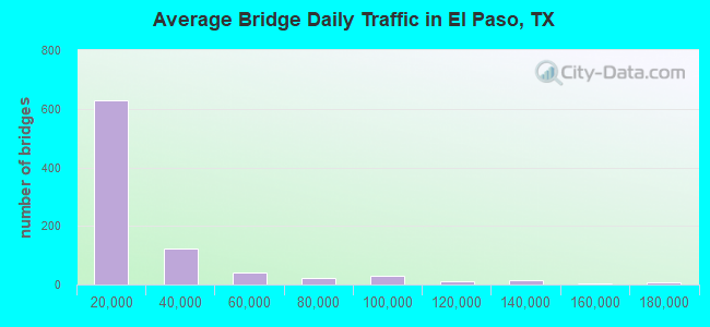
- 19,800,083Total average daily traffic
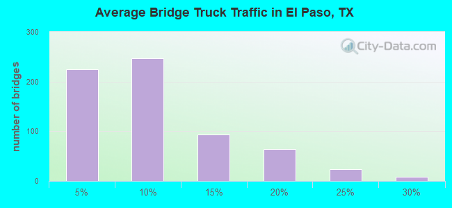
- 1,444,372Total average daily truck traffic
- National Bridge Inventory (NBI) Registered Bridges for El Paso
- No street view available for this location
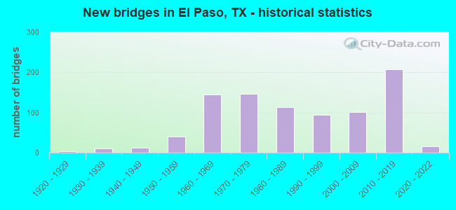
- New bridges - historical statistics
- 11910-1919
- 41920-1929
- 101930-1939
- 121940-1949
- 401950-1959
- 1441960-1969
- 1461970-1979
- 1131980-1989
- 941990-1999
- 1012000-2009
- 2072010-2019
- 162020-2022
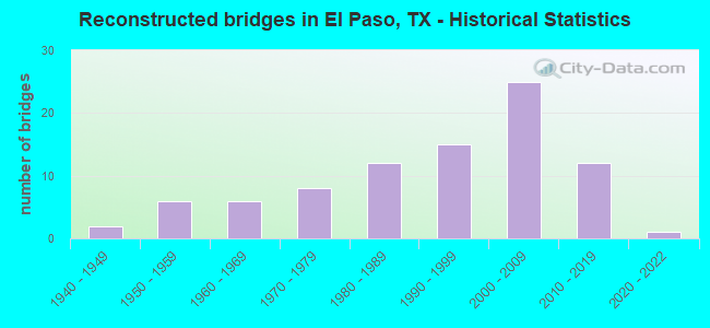
- Reconstructed bridges - Historical Statistics
- 21940-1949
- 61950-1959
- 61960-1969
- 81970-1979
- 121980-1989
- 151990-1999
- 252000-2009
- 122010-2019
- 12020-2022
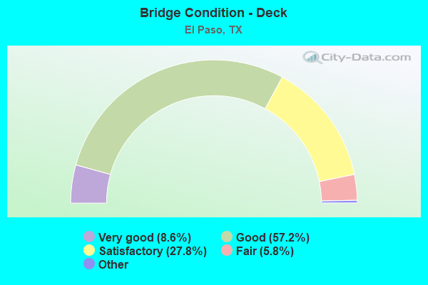
- Bridge Condition - Deck
- 8.6%Excellent
- 57.2%Very good
- 27.8%Good
- 5.8%Satisfactory
- 0.6%Fair
- 0.2%Poor
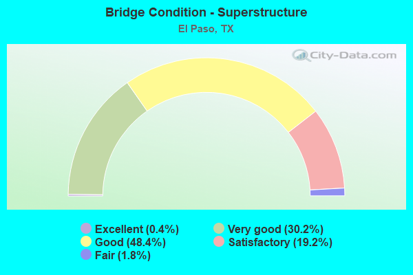
- Bridge Condition - Superstructure
- 0.4%Excellent
- 30.2%Very good
- 48.4%Good
- 19.2%Satisfactory
- 1.8%Fair
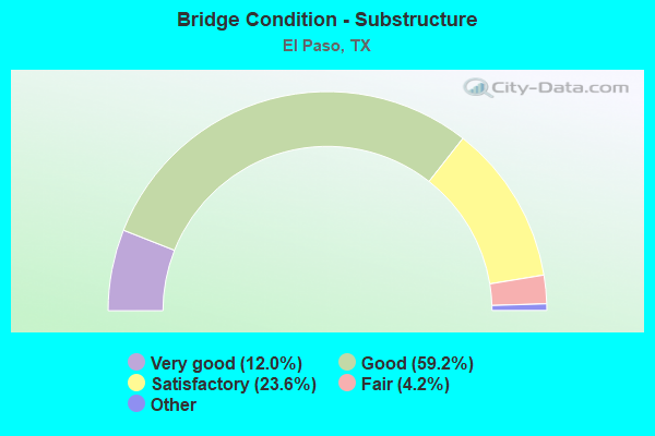
- Bridge Condition - Substructure
- 12.0%Excellent
- 59.2%Very good
- 23.6%Good
- 4.2%Satisfactory
- 1.0%Fair
- 0.6%Poor
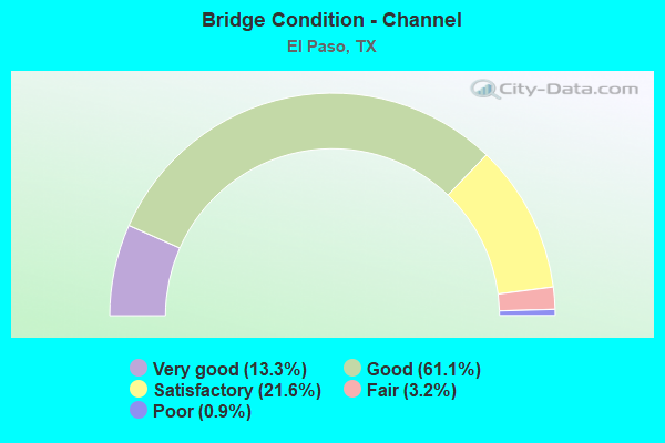
- Bridge Condition - Channel
- 13.3%Very good
- 61.1%Good
- 21.6%Satisfactory
- 3.2%Fair
- 0.9%Poor
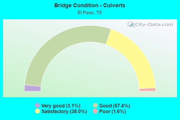
- Bridge Condition - Culverts
- 3.1%Very good
- 57.4%Good
- 38.0%Satisfactory
- 1.6%Poor
Find on map >> Show street view
Structure Number: 240720255203273, Location: 3.1 MI S OF US 62 (Lat: 31.761033, Lng: -106.267925), Route carried "under" structure: City street , Year Built: 2006, Structure Length: 0. m, Average Daily Traffic: 22,542 (year 2015), Features Intersected: MONTWOOD DR, Facility Carried by Structure: LP 375
Minimum Vertical Clearance: 5.36m (17.59ft), Kilometerpoint: 8.381, Lanes on structure: 6, Lanes under structure: 10, Material/Design: Prestressed concrete, Design/Construction: Stringer/Multi-beam, Length of Maximum Span: 36.3m (119.1ft)
Find on map >> Show street view
Structure Number: 240720255203274, Location: 2.1 MI S OF US 62 (Lat: 31.776694, Lng: -106.268111), Route carried "under" structure: City street , Year Built: 2006, Structure Length: 0. m, Average Daily Traffic: 8,634 (year 2015), Features Intersected: PEBBLE HILLS BLVD, Facility Carried by Structure: SL 375
Minimum Vertical Clearance: 5.08m (16.67ft), Kilometerpoint: 6.780, Lanes on structure: 4, Lanes under structure: 8, Material/Design: Prestressed concrete, Design/Construction: Stringer/Multi-beam, Length of Maximum Span: 36.3m (119.1ft)
Find on map >> Show street view
Structure Number: 240720255203275, Location: 3.0 MI S OF US 62 (Lat: 31.762950, Lng: -106.267994), Route carried "under" structure: State highway 659, Year Built: 2006, Structure Length: 0. m, Average Daily Traffic: 38,050 (year 2011), Features Intersected: ZARAGOSA (FM 659), Facility Carried by Structure: SL 375
Minimum Vertical Clearance: 5.41m (17.75ft), Kilometerpoint: 7.726, Lanes on structure: 6, Lanes under structure: 6, Material/Design: Steel, Design/Construction: Stringer/Multi-beam, Length of Maximum Span: 41.1m (134.8ft)
Find on map >> Show street view
Structure Number: 24072025520329, Location: LP 375 & FM 659 I/C (Lat: 31.761719, Lng: -106.267350), Route carried "under" structure: ServiceState highway 375, Year Built: 2013, Structure Length: 0. m, Average Daily Traffic: 4,500 (year 2018), Truck Traffic: 5%, Features Intersected: LP 375 NBFR
Minimum Vertical Clearance: 4.62m (15.16ft), Kilometerpoint: 45.850, Lanes on structure: 1, Lanes under structure: 17, Material/Design: Steel continuous, Design/Construction: Stringer/Multi-beam, Length of Maximum Span: 73.5m (241.1ft)
Find on map >> Show street view
Structure Number: 240720255203291, Location: LP 375 & FM 659 I/C (Lat: 31.761819, Lng: -106.267831), Route carried "under" structure: State highway 375, Year Built: 2013, Structure Length: 0. m, Average Daily Traffic: 3,000 (year 2018), Features Intersected: LP 375, Facility Carried by Structure: FM 659 SB CONN
Minimum Vertical Clearance: 5.72m (18.77ft), Kilometerpoint: 46.092, Lanes on structure: 1, Lanes under structure: 4, Material/Design: Steel continuous, Design/Construction: Stringer/Multi-beam, Length of Maximum Span: 73.5m (241.1ft)
Find on map >> Show street view
Structure Number: 240720255204022, Location: EL PASO ST & MEXICO BORD (Lat: 31.747719, Lng: -106.486933), Route carried "under" structure: State highway 375, Year Built: 1967, Structure Length: 0. m, Average Daily Traffic: 7,720 (year 2015), Truck Traffic: 7%, Features Intersected: LOOP 375, Facility Carried by Structure: EL PASO ST.
Minimum Vertical Clearance: 6.02m (19.75ft), Kilometerpoint: 20.794, Lanes on structure: 4, Lanes under structure: 4, Material/Design: Prestressed concrete, Design/Construction: Stringer/Multi-beam, Length of Maximum Span: 22.9m (75.1ft)
Find on map >> Show street view
Structure Number: 240720255204023, Location: AT STANTON ST & MEXICO BO (Lat: 31.748400, Lng: -106.482622), Route carried "under" structure: State highway 375, Year Built: 1967, Structure Length: 0. m, Average Daily Traffic: 3,086 (year 2017), Truck Traffic: 6%, Features Intersected: LOOP-375, Facility Carried by Structure: STANTON ST.
Minimum Vertical Clearance: 6.02m (19.75ft), Kilometerpoint: 20.413, Lanes on structure: 3, Lanes under structure: 4, Material/Design: Prestressed concrete, Design/Construction: Stringer/Multi-beam, Length of Maximum Span: 21.3m (69.9ft)
Find on map >> Show street view
Structure Number: 240720255204024, Location: 4.7 MI SE OF US 54 (Lat: 31.731569, Lng: -106.378408), Route carried "under" structure: City street , Year Built: 1979, Structure Length: 0. m, Average Daily Traffic: 1,000 (year 2009), Features Intersected: MIDWAY DR, Facility Carried by Structure: LOOP 375 WB
Minimum Vertical Clearance: 5.01m (16.44ft), Kilometerpoint: 1.003, Lanes on structure: 3, Lanes under structure: 4, Material/Design: Prestressed concrete, Design/Construction: Stringer/Multi-beam, Length of Maximum Span: 27.4m (89.9ft)
Find on map >> Show street view
Structure Number: 240720255204025, Location: 4.7 MI SE OF US 54 (Lat: 31.731511, Lng: -106.378500), Route carried "under" structure: City street , Year Built: 1979, Structure Length: 0. m, Average Daily Traffic: 1,000 (year 2009), Features Intersected: MIDWAY DR, Facility Carried by Structure: LOOP 375 EB
Minimum Vertical Clearance: 5.01m (16.44ft), Kilometerpoint: 1.025, Lanes on structure: 3, Lanes under structure: 4, Material/Design: Prestressed concrete, Design/Construction: Stringer/Multi-beam, Length of Maximum Span: 27.4m (89.9ft)
Find on map >> Show street view
Structure Number: 240720255204026, Location: 6.3 MI SE OF US 54 (Lat: 31.711450, Lng: -106.367808), Route carried "under" structure: City street , Year Built: 1982, Structure Length: 0. m, Average Daily Traffic: 1,000 (year 2009), Features Intersected: YARBROUGH DR, Facility Carried by Structure: LOOP 375 WB
Minimum Vertical Clearance: 4.88m (16.01ft), Kilometerpoint: 11.327, Lanes on structure: 3, Lanes under structure: 4, Material/Design: Prestressed concrete, Design/Construction: Stringer/Multi-beam, Length of Maximum Span: 27.4m (89.9ft)
Find on map >> Show street view
Structure Number: 240720255204027, Location: 6.3 MI SE OF US 54 (Lat: 31.711369, Lng: -106.367858), Route carried "under" structure: City street , Year Built: 1982, Structure Length: 0. m, Average Daily Traffic: 1,000 (year 2009), Features Intersected: YARBROUGH DR, Facility Carried by Structure: LOOP 375 EB
Minimum Vertical Clearance: 4.88m (16.01ft), Kilometerpoint: 11.446, Lanes on structure: 3, Lanes under structure: 4, Material/Design: Prestressed concrete, Design/Construction: Stringer/Multi-beam, Length of Maximum Span: 27.4m (89.9ft)
Find on map >> Show street view
Structure Number: 240720255204028, Location: 1.9 MI SE OF US 54 (Lat: 31.753419, Lng: -106.418122), Route carried "under" structure: City street , Year Built: 1987, Structure Length: 0. m, Average Daily Traffic: 1,000 (year 2009), Features Intersected: FONSECA DR, Facility Carried by Structure: LOOP 375 WB
Minimum Vertical Clearance: 5.01m (16.44ft), Kilometerpoint: 0.933, Lanes on structure: 3, Lanes under structure: 4, Material/Design: Prestressed concrete, Design/Construction: Box Beam or Girders - Multiple, Length of Maximum Span: 27.4m (89.9ft)
Find on map >> Show street view
Structure Number: 240720255204029, Location: 1.9 MI SE OF US 54 (Lat: 31.753319, Lng: -106.418131), Route carried "under" structure: City street , Year Built: 1987, Structure Length: 0. m, Average Daily Traffic: 1,000 (year 2009), Features Intersected: FONSECA DR, Facility Carried by Structure: LOOP 375 EB
Minimum Vertical Clearance: 5.01m (16.44ft), Kilometerpoint: 0.859, Lanes on structure: 3, Lanes under structure: 4, Material/Design: Prestressed concrete, Design/Construction: Box Beam or Girders - Multiple, Length of Maximum Span: 27.4m (89.9ft)
Find on map >> Show street view
Structure Number: 240720255204046, Location: 8.2 MI SE OF US 54 (Lat: 31.691850, Lng: -106.345056), Route carried "under" structure: City street , Year Built: 1997, Structure Length: 0. m, Average Daily Traffic: 1,000 (year 2009), Features Intersected: PADRES DR, Facility Carried by Structure: LOOP 375 EB
Minimum Vertical Clearance: 5.11m (16.77ft), Kilometerpoint: 1.054, Lanes on structure: 3, Lanes under structure: 4, Material/Design: Prestressed concrete, Design/Construction: Stringer/Multi-beam, Length of Maximum Span: 27.4m (89.9ft)
Find on map >> Show street view
Structure Number: 240720255204047, Location: 8.2 MI SE OF US 54 (Lat: 31.691475, Lng: -106.344583), Route carried "under" structure: City street , Year Built: 1997, Structure Length: 0. m, Average Daily Traffic: 1,000 (year 2009), Features Intersected: PADRES DR, Facility Carried by Structure: LOOP 375 WB
Minimum Vertical Clearance: 5.11m (16.77ft), Kilometerpoint: 1.032, Lanes on structure: 3, Lanes under structure: 4, Material/Design: Prestressed concrete, Design/Construction: Stringer/Multi-beam, Length of Maximum Span: 27.4m (89.9ft)
Find on map >> Show street view
Structure Number: 240720255204304, Location: US62/SL375 INTERCHANGE (Lat: 31.760183, Lng: -106.471267), Route carried "under" structure: State highway 375, Year Built: 2018, Structure Length: 0. m, Average Daily Traffic: 15,250 (year 2013), Truck Traffic: 1%, Features Intersected: US62 SL375 DELTA UPRR CO
Minimum Vertical Clearance: 30+ m (98+ ft), Kilometerpoint: 10.913, Lanes on structure: 1, Lanes under structure: 14, Material/Design: Steel continuous, Design/Construction: Stringer/Multi-beam, Length of Maximum Span: 76.2m (250.0ft)
Find on map >> Show street view
Structure Number: 240720255204305, Location: 1.244 MI. WEST OF US 54 (Lat: 31.761067, Lng: -106.466600), Route carried "under" structure: US 62, Year Built: 2018, Structure Length: 0. m, Average Daily Traffic: 15,250 (year 2018), Truck Traffic: 1%, Features Intersected: US62/UPRR/Coles St./Delt
Minimum Vertical Clearance: 30+ m (98+ ft), Kilometerpoint: 10.979, Lanes on structure: 1, Lanes under structure: 14, Material/Design: Prestressed concrete, Design/Construction: Stringer/Multi-beam, Length of Maximum Span: 47.5m (155.8ft)
Find on map >> Show street view
Structure Number: 240720255204306, Location: .57 Mi. SE of IH 10 (Lat: 31.803517, Lng: -106.539933), Route carried "under" structure: City street , Year Built: 2018, Structure Length: 0. m, Average Daily Traffic: 15,400 (year 2015), Truck Traffic: 1%, Features Intersected: Doniphan Dr., Facility Carried by Structure: EB US 85
Minimum Vertical Clearance: 6.01m (19.72ft), Kilometerpoint: 1.801, Lanes on structure: 2, Lanes under structure: 5, Material/Design: Prestressed concrete, Design/Construction: Stringer/Multi-beam, Length of Maximum Span: 51.8m (169.9ft)
Find on map >> Show street view
Structure Number: 24072025520431, Location: AT JCT EXECUTIVE & SL 375 (Lat: 31.791378, Lng: -106.521742), Route carried "under" structure: State highway 375, Year Built: 2018, Structure Length: 0. m, Average Daily Traffic: 10,100 (year 2015), Truck Traffic: 10%, Features Intersected: SL 375, Facility Carried by Structure: EXECUTIVE CEN BLVD
Minimum Vertical Clearance: 5.33m (17.49ft), Kilometerpoint: 0.000, Lanes on structure: 6, Lanes under structure: 4, Toll: On toll road, Material/Design: Prestressed concrete, Design/Construction: Stringer/Multi-beam, Length of Maximum Span: 32.6m (107.0ft)
Find on map >> Show street view
Structure Number: 240720255204313, Location: .3 MI. W. JCT NEW MEX 273 (Lat: 31.805300, Lng: -106.541500), Route carried "under" structure: City street , Year Built: 2018, Structure Length: 0. m, Average Daily Traffic: 11,650 (year 2015), Features Intersected: RACETRACK DR., Facility Carried by Structure: SL 375 EB
Minimum Vertical Clearance: 8.11m (26.61ft), Kilometerpoint: 0.983, Lanes on structure: 3, Lanes under structure: 2, Material/Design: Prestressed concrete, Design/Construction: Stringer/Multi-beam, Length of Maximum Span: 30.2m (99.1ft)
Find on map >> Show street view
Structure Number: 240720255204314, Location: .3 Mi.W. Jct. New Mex.273 (Lat: 31.805300, Lng: -106.541500), Route carried "under" structure: City street , Year Built: 2018, Structure Length: 0. m, Average Daily Traffic: 11,650 (year 2015), Features Intersected: RACETRACK DR., Facility Carried by Structure: WBSL375/WB US85ER
Minimum Vertical Clearance: 8.14m (26.71ft), Kilometerpoint: 0.983, Lanes on structure: 3, Lanes under structure: 2, Material/Design: Prestressed concrete, Design/Construction: Stringer/Multi-beam, Length of Maximum Span: 30.2m (99.1ft)
Find on map >> Show street view
Structure Number: 240720255204315, Location: .3 Mi.W.Jct.New.Mex.273 (Lat: 31.805483, Lng: -106.540867), Route carried "under" structure: City street , Year Built: 2018, Structure Length: 0. m, Average Daily Traffic: 15,400 (year 2015), Features Intersected: Racetrack Dr., Facility Carried by Structure: US 85 WB
Minimum Vertical Clearance: 6.73m (22.08ft), Kilometerpoint: 0.000, Lanes on structure: 2, Lanes under structure: 2, Material/Design: Prestressed concrete, Design/Construction: Stringer/Multi-beam, Length of Maximum Span: 30.2m (99.1ft)
Find on map >> Show street view
Structure Number: 240720255204316, Location: .5 Mi.SE of IH 10 (Lat: 31.803050, Lng: -106.538883), Route carried "under" structure: City street , Year Built: 2018, Structure Length: 0. m, Average Daily Traffic: 23,300 (year 2015), Truck Traffic: 5%, Features Intersected: WB Doniphan Dr., Facility Carried by Structure: EB SL 375
Minimum Vertical Clearance: 5.30m (17.39ft), Kilometerpoint: 0.000, Lanes on structure: 2, Lanes under structure: 2, Material/Design: Prestressed concrete, Design/Construction: Stringer/Multi-beam, Length of Maximum Span: 48.8m (160.1ft)
Find on map >> Show street view
Structure Number: 240720255204317, Location: 0.04 MI SE OF US 85 (Lat: 31.802933, Lng: -106.538417), Route carried "under" structure: City street , Year Built: 2018, Structure Length: 0. m, Average Daily Traffic: 3,000 (year 2015), Truck Traffic: 5%, Features Intersected: DONIPHAN DRIVE WB, Facility Carried by Structure: SL 375 WB
Minimum Vertical Clearance: 5.64m (18.50ft), Kilometerpoint: 0.000, Lanes on structure: 2, Lanes under structure: 2, Material/Design: Prestressed concrete, Design/Construction: Stringer/Multi-beam, Length of Maximum Span: 49.7m (163.1ft)
Find on map >> Show street view
Structure Number: 240720255204319, Location: 3.50 MI NW OF SPUR 1966 (Lat: 31.802733, Lng: -106.537850), Route carried "under" structure: City street , Year Built: 2018, Structure Length: 0. m, Average Daily Traffic: 1,000 (year 2015), Truck Traffic: 2%, Features Intersected: DONIPHAN DRIVE, Facility Carried by Structure: SL 375 WB OFF RAMP
Minimum Vertical Clearance: 12.12m (39.76ft), Kilometerpoint: 0.000, Lanes on structure: 1, Lanes under structure: 2, Material/Design: Prestressed concrete, Design/Construction: Stringer/Multi-beam, Length of Maximum Span: 46.3m (151.9ft)
Find on map >> Show street view
Structure Number: 240720255204326, Location: AT JCT SPUR 1966 & SL 375 (Lat: 31.762983, Lng: -106.506494), Route carried "under" structure: State highway 375, Year Built: 2018, Structure Length: 0. m, Average Daily Traffic: 7,100 (year 2015), Truck Traffic: 10%, Features Intersected: SL 375
Minimum Vertical Clearance: 6.83m (22.41ft), Kilometerpoint: 0.000, Lanes on structure: 1, Lanes under structure: 4, Toll: On toll road, Material/Design: Prestressed concrete, Design/Construction: Stringer/Multi-beam, Length of Maximum Span: 29.3m (96.1ft)
Find on map >> Show street view
Structure Number: 240720255204327, Location: 0.17 MI SE OF SPUR 1966 (Lat: 31.761072, Lng: -106.505317), Route carried "under" structure: US 85, Year Built: 2018, Structure Length: 0. m, Average Daily Traffic: 17,954 (year 2018), Truck Traffic: 5%, Features Intersected: US 85 BNSF UP RAILROAD, Facility Carried by Structure: SL 375
Minimum Vertical Clearance: 12.80m (41.99ft), Kilometerpoint: 0.000, Lanes on structure: 4, Lanes under structure: 4, Material/Design: Prestressed concrete, Design/Construction: Stringer/Multi-beam, Length of Maximum Span: 44.2m (145.0ft)
Find on map >> Show street view
Structure Number: 240720359201001, Location: 1.4 MI E OF NM ST LINE (Lat: 31.879561, Lng: -106.605814), Route carried "under" structure: City street , Year Built: 2001, Structure Length: 0. m, Average Daily Traffic: 500 (year 2009), Features Intersected: STRAHAN RD., Facility Carried by Structure: SH 178(ARTCRAFT)
Minimum Vertical Clearance: 5.01m (16.44ft), Kilometerpoint: 0.002, Lanes on structure: 5, Lanes under structure: 2, Material/Design: Prestressed concrete, Design/Construction: Stringer/Multi-beam, Length of Maximum Span: 36.6m (120.1ft)
Find on map >> Show street view
Structure Number: 240720359201004, Location: 1.0 MI W OF IH 10 (Lat: 31.878450, Lng: -106.597167), Route carried "under" structure: Ramp State highway 178, Year Built: 2000, Structure Length: 0. m, Average Daily Traffic: 1,850 (year 2010), Truck Traffic: 27%, Features Intersected: SH 178 WB ON-RP
Minimum Vertical Clearance: 5.97m (19.59ft), Kilometerpoint: 3.190, Lanes on structure: 1, Lanes under structure: 1, Material/Design: Prestressed concrete, Design/Construction: Box Beam or Girders - Multiple, Length of Maximum Span: 32.0m (105.0ft)
Find on map >> Show street view
Structure Number: 240720359201005, Location: 1.0 MI W OF IH 10 (Lat: 31.878025, Lng: -106.599408), Route carried "under" structure: Ramp State highway 178, Year Built: 2000, Structure Length: 0. m, Average Daily Traffic: 1,850 (year 2010), Truck Traffic: 27%, Features Intersected: SH 178 EB ON-RP
Minimum Vertical Clearance: 5.03m (16.50ft), Kilometerpoint: 3.001, Lanes on structure: 1, Lanes under structure: 1, Material/Design: Prestressed concrete, Design/Construction: Box Beam or Girders - Multiple, Length of Maximum Span: 35.1m (115.2ft)
Find on map >> Show street view
Structure Number: 240720B00560003, Location: 1.9 MI W OF US 54 (Lat: 31.825500, Lng: -106.405039), Route carried "under" structure: City street , Year Built: 2008, Structure Length: 0. m, Average Daily Traffic: 1,500 (year 2018), Features Intersected: AIRPORT RD NB, Facility Carried by Structure: SGT. MAJOR BLVD
Minimum Vertical Clearance: 5.36m (17.59ft), Kilometerpoint: 0.161, Lanes on structure: 2, Lanes under structure: 2, Material/Design: Prestressed concrete, Design/Construction: Slab, Length of Maximum Span: 14.6m (47.9ft)
Find on map >> Show street view
Structure Number: 240720B00560004, Location: 0.35 MI S OF SP 601 (Lat: 31.819881, Lng: -106.404600), Route carried "under" structure: City street , Year Built: 2008, Structure Length: 0. m, Average Daily Traffic: 2,000 (year 2018), Features Intersected: AIRPORT RD, Facility Carried by Structure: HAAN RD
Minimum Vertical Clearance: 5.33m (17.49ft), Kilometerpoint: 0.563, Lanes on structure: 4, Lanes under structure: 6, Material/Design: Prestressed concrete, Design/Construction: Stringer/Multi-beam, Length of Maximum Span: 19.8m (65.0ft)
Find on map >> Show street view
Structure Number: 240720B00600006, Location: 0.40 MI N OF US 62 (Lat: 31.795369, Lng: -106.396200), Route carried "under" structure: City street , Year Built: 1969, Structure Length: 0. m, Average Daily Traffic: 34,700 (year 2015), Truck Traffic: 1%, Features Intersected: AIRWAY BLVD NB, Facility Carried by Structure: TERMINAL DR SB
Minimum Vertical Clearance: 4.83m (15.85ft), Kilometerpoint: 0.724, Lanes on structure: 2, Lanes under structure: 2, Material/Design: Steel, Design/Construction: Stringer/Multi-beam, Length of Maximum Span: 17.7m (58.1ft)
Find on map >> Show street view
Structure Number: 240720B22080001, Location: 0.15 MI W OF AIRWAY BLVD (Lat: 31.784028, Lng: -106.397989), Route carried "under" structure: City street , Year Built: 1973, Structure Length: 0. m, Average Daily Traffic: 1 (year 2017), Truck Traffic: 1%, Features Intersected: EDGEMERE BLBD, Facility Carried by Structure: EDGEMERE BLVD
Minimum Vertical Clearance: 4.37m (14.34ft), Kilometerpoint: 0.161, Lanes on structure: 4, Lanes under structure: 2, Material/Design: Prestressed concrete, Design/Construction: Stringer/Multi-beam, Length of Maximum Span: 29.0m (95.1ft)
Find on map >> Show street view
Structure Number: 240720B42270003, Location: 0.25 MI N OF FRED WILSON (Lat: 31.831597, Lng: -106.431758), Route carried "under" structure: City street 8005, Year Built: 1976, Structure Length: 0. m, Average Daily Traffic: 15,230 (year 2017), Features Intersected: MARSHALL RD, Facility Carried by Structure: MARSHALL RD
Minimum Vertical Clearance: 5.41m (17.75ft), Kilometerpoint: 9.286, Lanes on structure: 4, Lanes under structure: 6, Material/Design: Prestressed concrete, Design/Construction: Stringer/Multi-beam, Length of Maximum Span: 35.7m (117.1ft)
Find on map >> Show street view
Structure Number: 240720B52920009, Location: 0.02 MI S OF IH-10 (Lat: 31.776453, Lng: -106.461594), Route carried "under" structure: City street 1, Year Built: 1967, Structure Length: 0. m, Average Daily Traffic: 100 (year 2018), Truck Traffic: 1%, Features Intersected: N PIEDRAS ST, Facility Carried by Structure: N PIEDRAS ST
Minimum Vertical Clearance: 4.42m (14.50ft), Kilometerpoint: 1.609, Lanes on structure: 2, Lanes under structure: 4, Material/Design: Prestressed concrete, Design/Construction: Stringer/Multi-beam, Length of Maximum Span: 18.3m (60.0ft)
Find on map >> Show street view
Structure Number: 240720B55760011, Location: 0.25 MI S OF IH 10 (Lat: 37.772400, Lng: -106.432989), Route carried "under" structure: City street , Year Built: 1983, Structure Length: 0. m, Average Daily Traffic: 500 (year 2018), Truck Traffic: 1%, Features Intersected: ALBERTA AVENUE, Facility Carried by Structure: RAYNOLDS ST
Minimum Vertical Clearance: 4.95m (16.24ft), Kilometerpoint: 1.609, Lanes on structure: 4, Lanes under structure: 2, Material/Design: Prestressed concrete, Design/Construction: Box Beam or Girders - Multiple, Length of Maximum Span: 30.5m (100.1ft)
Find on map >> Show street view
Structure Number: 240720B5580301, Location: 0.03 MI S OF IH 10 (Lat: 31.776761, Lng: -106.460219), Route carried "under" structure: City street 48, Year Built: 1967, Structure Length: 0. m, Average Daily Traffic: 1 (year 2017), Features Intersected: N RAYNOS ST, Facility Carried by Structure: N RAYNOR ST
Minimum Vertical Clearance: 5.28m (17.32ft), Kilometerpoint: 1.609, Lanes on structure: 2, Lanes under structure: 4, Material/Design: Prestressed concrete, Design/Construction: Stringer/Multi-beam, Length of Maximum Span: 18.3m (60.0ft)
Find on map >> Show street view
Structure Number: 240720B67080011, Location: 0.02 MI E OF POPLAR ST (Lat: 31.774422, Lng: -106.462869), Route carried "under" structure: City street , Year Built: 1967, Structure Length: 0. m, Average Daily Traffic: 500 (year 2018), Features Intersected: TEXAS AVE RAMP, Facility Carried by Structure: TEXAS AVE RAMP
Minimum Vertical Clearance: 6.78m (22.24ft), Kilometerpoint: 1.609, Lanes on structure: 1, Lanes under structure: 4, Material/Design: Prestressed concrete, Design/Construction: Stringer/Multi-beam, Length of Maximum Span: 18.3m (60.0ft)