Bridge Statistics for El Paso, Texas (TX)
Condition, Traffic, Stress, Structural Evaluation, Project Costs
- National Bridge Inventory (NBI) Statistics
- 888Number of bridges
- 22,736ft / 6,930mTotal length
- $11,261,000Total costs
- 19,800,083Total average daily traffic
- 1,444,372Total average daily truck traffic
- National Bridge Inventory (NBI) Registered Bridges for El Paso
- No street view available for this location
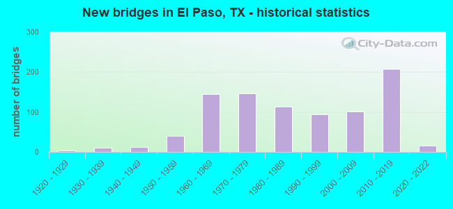
- New bridges - historical statistics
- 11910-1919
- 41920-1929
- 101930-1939
- 121940-1949
- 401950-1959
- 1441960-1969
- 1461970-1979
- 1131980-1989
- 941990-1999
- 1012000-2009
- 2072010-2019
- 162020-2022
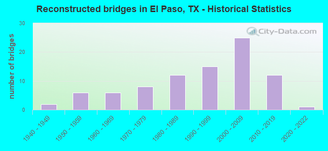
- Reconstructed bridges - Historical Statistics
- 21940-1949
- 61950-1959
- 61960-1969
- 81970-1979
- 121980-1989
- 151990-1999
- 252000-2009
- 122010-2019
- 12020-2022
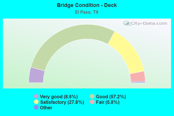
- Bridge Condition - Deck
- 8.6%Excellent
- 57.2%Very good
- 27.8%Good
- 5.8%Satisfactory
- 0.6%Fair
- 0.2%Poor
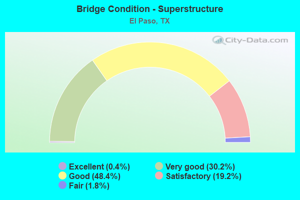
- Bridge Condition - Superstructure
- 0.4%Excellent
- 30.2%Very good
- 48.4%Good
- 19.2%Satisfactory
- 1.8%Fair
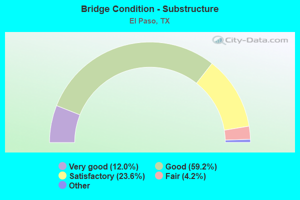
- Bridge Condition - Substructure
- 12.0%Excellent
- 59.2%Very good
- 23.6%Good
- 4.2%Satisfactory
- 1.0%Fair
- 0.6%Poor
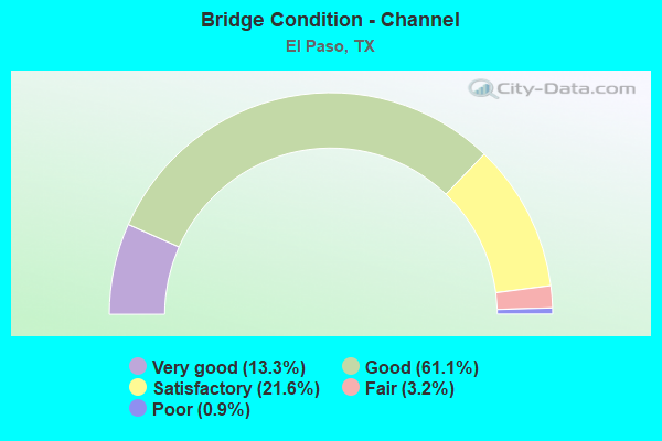
- Bridge Condition - Channel
- 13.3%Very good
- 61.1%Good
- 21.6%Satisfactory
- 3.2%Fair
- 0.9%Poor
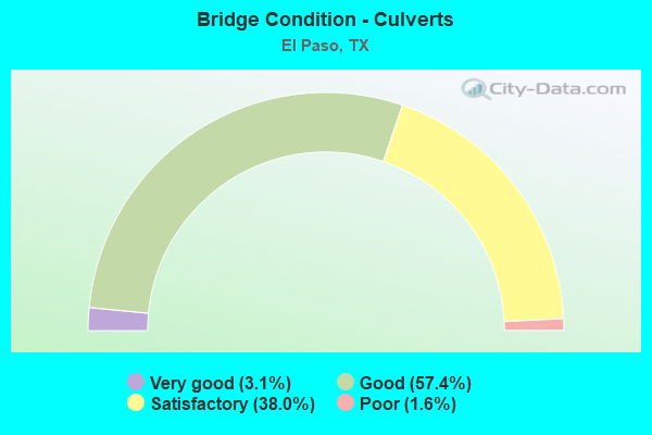
- Bridge Condition - Culverts
- 3.1%Very good
- 57.4%Good
- 38.0%Satisfactory
- 1.6%Poor
Find on map >> Show street view
Structure Number: 240720255204306, Location: .57 Mi. SE of IH 10 (Lat: 31.803517, Lng: -106.539933), Route carried "on" structure: US 85, Year Built: 2018, Status: Open, Structure Length: 18.07m (59.28ft), Average Daily Traffic: 13,100 (year 2015), Truck Traffic: 5%, Average Future Daily Traffic: 17,200 (year 2035), Design Load: HL 93, Features Intersected: DONIPHAN DR/MCNUTT/BNSF
Minimum Vertical Clearance: 6.01m (19.72ft), Kilometerpoint: 1.825, Lanes on structure: 2, Lanes under structure: 5, Owner: State Highway Agency, Approaching Roadway Width: 11.0m (36.1ft), Skew: 6 degrees, Material/Design: Prestressed concrete, Design/Construction: Stringer/Multi-beam, Number Of Spans In Main Unit: 3, Number Of Approach Spans: 1, Length of Maximum Span: 51.8m (169.9ft), Curb-To-Curb Width: 11.0m (36.1ft), Out-to-Out Width: 11.6m (38.1ft)
Condition: Deck: Very good, Superstructure: Very good, Substructure: Very good, Operating Rating: 54.4 metric tons, Method Used To Determine Operating Rating: Assigned ratings based on Load and Resistance Factor Design (LRFD) reported in metric tons, Inventory Rating: 32.7 metric tons, Method Used To Determine Inventory Rating: Assigned ratings based on Load and Resistance Factor Design (LRFD) reported in metric tons, Structural Evaluation: Equal to present desirable criteria, Deck Geometry: Somewhat better than minimum adequacy, Underclear: High priority of corrective action, Approach Roadway Alignment: Equal to present desirable criteria, Designated Inspection Frequency: Every 24 months, Inspection Date: August 2021, Deck Structure Type: Concrete Cast-file-Place
Find on map >> Show street view
Structure Number: 240720255204307, Location: 1.85 MI SE OF US 85 (Lat: 31.792700, Lng: -106.523547), Route carried "on" structure: State highway 375, Year Built: 2018, Status: Open, Structure Length: 14.42m (47.31ft), Average Daily Traffic: 23,300 (year 2015), Truck Traffic: 5%, Average Future Daily Traffic: 33,200 (year 2035), Design Load: HL 93, Features Intersected: WATER #2 AND ACCESS ROAD
Minimum Vertical Clearance: 30+ m (98+ ft), Kilometerpoint: 0.000, Lanes on structure: 4, Lanes under structure: 2, Base Highway Network: Yes, Toll: On toll road, Owner: Local Toll Authority, Approaching Roadway Width: 25.6m (84.0ft), Skew: 31 degrees, Material/Design: Prestressed concrete, Design/Construction: Stringer/Multi-beam, Number Of Spans In Main Unit: 4, Length of Maximum Span: 40.8m (133.9ft), Curb-To-Curb Width: 25.7m (84.3ft), Out-to-Out Width: 27.1m (88.9ft)
Condition: Deck: Good, Superstructure: Very good, Substructure: Good, Channel: Very good, Operating Rating: 54.4 metric tons, Method Used To Determine Operating Rating: Assigned ratings based on Load and Resistance Factor Design (LRFD) reported in metric tons, Inventory Rating: 32.7 metric tons, Method Used To Determine Inventory Rating: Assigned ratings based on Load and Resistance Factor Design (LRFD) reported in metric tons, Structural Evaluation: Better than present minimum criteria, Deck Geometry: Superior to present desirable criteria, Underclear: Meets minimum limits, Waterway Adequacy: Superior to present desirable criteria, Approach Roadway Alignment: Equal to present desirable criteria, Designated Inspection Frequency: Every 24 months, Inspection Date: August 2021, Deck Structure Type: Concrete Cast-file-Place
Find on map >> Show street view
Structure Number: 240720255204308, Location: AT EXECUTIVE CENTER BLVD (Lat: 31.792667, Lng: -106.523589), Route carried "on" structure: Ramp State highway 375, Year Built: 2018, Status: Open, Structure Length: 12.95m (42.49ft), Average Daily Traffic: 1,500 (year 2015), Truck Traffic: 10%, Average Future Daily Traffic: 2,500 (year 2035), Design Load: HL 93, Features Intersected: WATER #2 AND ACCESS RD
Minimum Vertical Clearance: 30+ m (98+ ft), Kilometerpoint: 0.000, Lanes on structure: 2, Lanes under structure: 2, Toll: On toll road, Owner: Local Toll Authority, Approaching Roadway Width: 14.6m (47.9ft), Skew: 9 degrees, Material/Design: Prestressed concrete, Design/Construction: Stringer/Multi-beam, Number Of Spans In Main Unit: 3, Length of Maximum Span: 45.1m (148.0ft), Curb-To-Curb Width: 14.5m (47.6ft), Out-to-Out Width: 15.4m (50.5ft)
Condition: Deck: Very good, Superstructure: Very good, Substructure: Very good, Channel: Very good, Operating Rating: 54.4 metric tons, Method Used To Determine Operating Rating: Assigned ratings based on Load and Resistance Factor Design (LRFD) reported in metric tons, Inventory Rating: 32.7 metric tons, Method Used To Determine Inventory Rating: Assigned ratings based on Load and Resistance Factor Design (LRFD) reported in metric tons, Structural Evaluation: Equal to present desirable criteria, Deck Geometry: Superior to present desirable criteria, Underclear: Meets minimum limits, Waterway Adequacy: Superior to present desirable criteria, Approach Roadway Alignment: Equal to present desirable criteria, Designated Inspection Frequency: Every 24 months, Inspection Date: August 2021, Deck Structure Type: Concrete Cast-file-Place
Find on map >> Show street view
Structure Number: 240720255204309, Location: AT EXECUTIVE CENTER BLVD (Lat: 31.792181, Lng: -106.522058), Route carried "on" structure: Ramp State highway 375, Year Built: 2018, Status: Open, Structure Length: 15.94m (52.30ft), Average Daily Traffic: 1,500 (year 2015), Truck Traffic: 5%, Average Future Daily Traffic: 2,500 (year 2035), Design Load: HL 93, Features Intersected: WATER #2 AND ACCESS RD
Minimum Vertical Clearance: 30+ m (98+ ft), Kilometerpoint: 0.000, Lanes on structure: 1, Lanes under structure: 2, Toll: On toll road, Owner: Local Toll Authority, Approaching Roadway Width: 7.6m (24.9ft), Skew: 9 degrees, Material/Design: Prestressed concrete, Design/Construction: Stringer/Multi-beam, Number Of Spans In Main Unit: 4, Length of Maximum Span: 40.8m (133.9ft), Curb-To-Curb Width: 7.7m (25.3ft), Out-to-Out Width: 8.5m (27.9ft)
Condition: Deck: Good, Superstructure: Very good, Substructure: Very good, Channel: Very good, Operating Rating: 54.4 metric tons, Method Used To Determine Operating Rating: Assigned ratings based on Load and Resistance Factor Design (LRFD) reported in metric tons, Inventory Rating: 32.7 metric tons, Method Used To Determine Inventory Rating: Assigned ratings based on Load and Resistance Factor Design (LRFD) reported in metric tons, Structural Evaluation: Equal to present desirable criteria, Deck Geometry: Better than present minimum criteria, Underclear: Meets minimum limits, Waterway Adequacy: Superior to present desirable criteria, Approach Roadway Alignment: Equal to present desirable criteria, Designated Inspection Frequency: Every 24 months, Inspection Date: August 2021, Deck Structure Type: Concrete Cast-file-Place
Find on map >> Show street view
Structure Number: 24072025520431, Location: AT JCT EXECUTIVE & SL 375 (Lat: 31.791378, Lng: -106.521742), Route carried "on" structure: City street , Year Built: 2018, Status: Open, Structure Length: 3.26m (10.70ft), Average Daily Traffic: 2,500 (year 2015), Truck Traffic: 10%, Average Future Daily Traffic: 10,000 (year 2035), Design Load: HL 93, Features Intersected: SL 375, Facility Carried by Structure: EXECUTIVE CEN BLVD
Minimum Vertical Clearance: 30+ m (98+ ft), Kilometerpoint: 0.000, Lanes on structure: 6, Lanes under structure: 4, Owner: City or Municipal Highway Agency, Approaching Roadway Width: 28.7m (94.2ft), Material/Design: Prestressed concrete, Design/Construction: Stringer/Multi-beam, Number Of Spans In Main Unit: 1, Length of Maximum Span: 32.6m (107.0ft), Curb or Sidewalk Widths: Left: 2.8m (9.2ft), Right: 3.0m (9.8ft), Curb-To-Curb Width: 28.6m (93.8ft), Out-to-Out Width: 68.6m (225.1ft)
Condition: Deck: Good, Superstructure: Very good, Substructure: Very good, Operating Rating: 54.4 metric tons, Method Used To Determine Operating Rating: Assigned ratings based on Load and Resistance Factor Design (LRFD) reported in metric tons, Inventory Rating: 32.7 metric tons, Method Used To Determine Inventory Rating: Assigned ratings based on Load and Resistance Factor Design (LRFD) reported in metric tons, Structural Evaluation: Equal to present desirable criteria, Deck Geometry: Superior to present desirable criteria, Underclear: High priority of corrective action, Approach Roadway Alignment: Equal to present desirable criteria, Designated Inspection Frequency: Every 24 months, Inspection Date: August 2021, Deck Structure Type: Concrete Cast-file-Place
Find on map >> Show street view
Structure Number: 240720255204311, Location: 0.18 MI SE OF US 85 (Lat: 31.801967, Lng: -106.537083), Route carried "on" structure: State highway 375, Year Built: 2018, Status: Open, Structure Length: 11.34m (37.20ft), Average Daily Traffic: 23,300 (year 2015), Truck Traffic: 10%, Average Future Daily Traffic: 35,000 (year 2035), Design Load: HL 93, Features Intersected: WATER # 6 & FUTURE DR
Minimum Vertical Clearance: 30+ m (98+ ft), Kilometerpoint: 0.000, Lanes on structure: 4, Base Highway Network: Yes, Toll: On toll road, Owner: Local Toll Authority, Approaching Roadway Width: 26.8m (87.9ft), Skew: 31 degrees, Material/Design: Prestressed concrete, Design/Construction: Stringer/Multi-beam, Number Of Spans In Main Unit: 2, Number Of Approach Spans: 1, Length of Maximum Span: 42.1m (138.1ft), Curb-To-Curb Width: 27.2m (89.2ft), Out-to-Out Width: 28.7m (94.2ft)
Condition: Deck: Good, Superstructure: Very good, Substructure: Very good, Channel: Very good, Operating Rating: 54.4 metric tons, Method Used To Determine Operating Rating: Assigned ratings based on Load and Resistance Factor Design (LRFD) reported in metric tons, Inventory Rating: 32.7 metric tons, Method Used To Determine Inventory Rating: Assigned ratings based on Load and Resistance Factor Design (LRFD) reported in metric tons, Structural Evaluation: Equal to present desirable criteria, Deck Geometry: Superior to present desirable criteria, Waterway Adequacy: Superior to present desirable criteria, Approach Roadway Alignment: Equal to present desirable criteria, Designated Inspection Frequency: Every 24 months, Inspection Date: August 2021, Deck Structure Type: Concrete Cast-file-Place
Find on map >> Show street view
Structure Number: 240720255204312, Location: 0.20 MI SE OF US 85 (Lat: 31.801733, Lng: -106.536150), Route carried "on" structure: Ramp State highway 375, Year Built: 2018, Status: Open, Structure Length: 8.35m (27.40ft), Average Daily Traffic: 2,000 (year 2015), Truck Traffic: 5%, Average Future Daily Traffic: 4,000 (year 2035), Design Load: HL 93, Features Intersected: WATER # 6
Minimum Vertical Clearance: 30+ m (98+ ft), Kilometerpoint: 0.000, Lanes on structure: 1, Toll: On toll road, Owner: Local Toll Authority, Approaching Roadway Width: 7.6m (24.9ft), Skew: 1 degrees, Material/Design: Prestressed concrete, Design/Construction: Stringer/Multi-beam, Number Of Spans In Main Unit: 2, Length of Maximum Span: 42.1m (138.1ft), Curb-To-Curb Width: 7.7m (25.3ft), Out-to-Out Width: 8.5m (27.9ft)
Condition: Deck: Good, Superstructure: Very good, Substructure: Very good, Channel: Very good, Operating Rating: 54.4 metric tons, Method Used To Determine Operating Rating: Assigned ratings based on Load and Resistance Factor Design (LRFD) reported in metric tons, Inventory Rating: 32.7 metric tons, Method Used To Determine Inventory Rating: Assigned ratings based on Load and Resistance Factor Design (LRFD) reported in metric tons, Structural Evaluation: Equal to present desirable criteria, Deck Geometry: Better than present minimum criteria, Waterway Adequacy: Superior to present desirable criteria, Approach Roadway Alignment: Equal to present desirable criteria, Designated Inspection Frequency: Every 24 months, Inspection Date: August 2021, Deck Structure Type: Concrete Cast-file-Place
Find on map >> Show street view
Structure Number: 240720255204313, Location: .3 MI. W. JCT NEW MEX 273 (Lat: 31.805508, Lng: -106.541478), Route carried "on" structure: State highway 375, Year Built: 2018, Status: Open, Structure Length: 3.02m (9.91ft), Average Daily Traffic: 11,650 (year 2015), Truck Traffic: 9%, Average Future Daily Traffic: 1 (year 1900), Design Load: HL 93, Features Intersected: RACETRACK DR.
Minimum Vertical Clearance: 30+ m (98+ ft), Kilometerpoint: 0.983, Lanes on structure: 3, Lanes under structure: 2, Base Highway Network: Yes, Owner: State Highway Agency, Approaching Roadway Width: 17.1m (56.1ft), Material/Design: Prestressed concrete, Design/Construction: Stringer/Multi-beam, Number Of Spans In Main Unit: 1, Length of Maximum Span: 30.2m (99.1ft), Curb-To-Curb Width: 17.1m (56.1ft), Out-to-Out Width: 17.7m (58.1ft)
Condition: Deck: Very good, Superstructure: Very good, Substructure: Very good, Operating Rating: 54.4 metric tons, Method Used To Determine Operating Rating: Assigned ratings based on Load and Resistance Factor Design (LRFD) reported in metric tons, Inventory Rating: 32.7 metric tons, Method Used To Determine Inventory Rating: Assigned ratings based on Load and Resistance Factor Design (LRFD) reported in metric tons, Structural Evaluation: Equal to present desirable criteria, Deck Geometry: Equal to present minimum criteria, Underclear: Superior to present desirable criteria, Approach Roadway Alignment: Equal to present desirable criteria, Designated Inspection Frequency: Every 24 months, Inspection Date: August 2021, Deck Structure Type: Concrete Cast-file-Place
Find on map >> Show street view
Structure Number: 240720255204314, Location: .3 Mi.W. Jct. New Mex.273 (Lat: 31.805383, Lng: -106.541083), Route carried "on" structure: State highway 375, Year Built: 2018, Status: Open, Structure Length: 3.02m (9.91ft), Average Daily Traffic: 11,650 (year 2015), Truck Traffic: 1%, Average Future Daily Traffic: 1 (year 1900), Design Load: HL 93, Features Intersected: Racetrack Dr.
Minimum Vertical Clearance: 30+ m (98+ ft), Kilometerpoint: 0.983, Lanes on structure: 3, Lanes under structure: 2, Owner: State Highway Agency, Approaching Roadway Width: 20.4m (66.9ft), Material/Design: Prestressed concrete, Design/Construction: Stringer/Multi-beam, Number Of Spans In Main Unit: 1, Length of Maximum Span: 30.2m (99.1ft), Curb-To-Curb Width: 20.6m (67.6ft), Out-to-Out Width: 23.0m (75.5ft)
Condition: Deck: Good, Superstructure: Very good, Substructure: Very good, Operating Rating: 54.4 metric tons, Method Used To Determine Operating Rating: Assigned ratings based on Load and Resistance Factor Design (LRFD) reported in metric tons, Inventory Rating: 32.7 metric tons, Method Used To Determine Inventory Rating: Assigned ratings based on Load and Resistance Factor Design (LRFD) reported in metric tons, Structural Evaluation: Equal to present desirable criteria, Deck Geometry: Superior to present desirable criteria, Underclear: Superior to present desirable criteria, Approach Roadway Alignment: Equal to present desirable criteria, Designated Inspection Frequency: Every 24 months, Inspection Date: August 2021, Deck Structure Type: Concrete Cast-file-Place
Find on map >> Show street view
Structure Number: 240720255204315, Location: .3 Mi.W.Jct.New.Mex.273 (Lat: 31.805483, Lng: -106.540867), Route carried "on" structure: Ramp US 85, Year Built: 2018, Status: Open, Structure Length: 3.02m (9.91ft), Average Daily Traffic: 15,400 (year 2015), Average Future Daily Traffic: 21,305 (year 2035), Design Load: HL 93, Features Intersected: Racetrack Dr.
Minimum Vertical Clearance: 6.73m (22.08ft), Kilometerpoint: 1.490, Lanes on structure: 2, Lanes under structure: 2, Base Highway Network: Yes, Owner: State Highway Agency, Approaching Roadway Width: 12.5m (41.0ft), Material/Design: Prestressed concrete, Design/Construction: Stringer/Multi-beam, Number Of Spans In Main Unit: 1, Length of Maximum Span: 30.2m (99.1ft), Curb-To-Curb Width: 12.7m (41.7ft), Out-to-Out Width: 13.3m (43.6ft)
Condition: Deck: Good, Superstructure: Very good, Substructure: Good, Operating Rating: 54.4 metric tons, Method Used To Determine Operating Rating: Assigned ratings based on Load and Resistance Factor Design (LRFD) reported in metric tons, Inventory Rating: 32.7 metric tons, Method Used To Determine Inventory Rating: Assigned ratings based on Load and Resistance Factor Design (LRFD) reported in metric tons, Structural Evaluation: Better than present minimum criteria, Deck Geometry: Superior to present desirable criteria, Underclear: Superior to present desirable criteria, Approach Roadway Alignment: Equal to present desirable criteria, Designated Inspection Frequency: Every 24 months, Inspection Date: August 2021, Deck Structure Type: Concrete Cast-file-Place
Find on map >> Show street view
Structure Number: 240720255204316, Location: .5 Mi.SE of IH 10 (Lat: 31.803050, Lng: -106.538883), Route carried "on" structure: State highway 375, Year Built: 2018, Status: Open, Structure Length: 4.88m (16.01ft), Average Daily Traffic: 23,300 (year 2015), Truck Traffic: 5%, Average Future Daily Traffic: 33,200 (year 2035), Design Load: HL 93, Features Intersected: WB Doniphan Dr.
Minimum Vertical Clearance: 5.30m (17.39ft), Kilometerpoint: 0.000, Lanes on structure: 2, Lanes under structure: 2, Base Highway Network: Yes, Owner: State Highway Agency, Approaching Roadway Width: 14.9m (48.9ft), Skew: 7 degrees, Material/Design: Prestressed concrete, Design/Construction: Stringer/Multi-beam, Number Of Spans In Main Unit: 1, Length of Maximum Span: 48.8m (160.1ft), Curb-To-Curb Width: 14.2m (46.6ft), Out-to-Out Width: 14.8m (48.6ft)
Condition: Deck: Very good, Superstructure: Very good, Substructure: Very good, Operating Rating: 54.4 metric tons, Method Used To Determine Operating Rating: Assigned ratings based on Load and Resistance Factor Design (LRFD) reported in metric tons, Inventory Rating: 32.7 metric tons, Method Used To Determine Inventory Rating: Assigned ratings based on Load and Resistance Factor Design (LRFD) reported in metric tons, Structural Evaluation: Equal to present desirable criteria, Deck Geometry: Superior to present desirable criteria, Underclear: High priority of corrective action, Approach Roadway Alignment: Better than present minimum criteria, Designated Inspection Frequency: Every 24 months, Inspection Date: August 2021, Deck Structure Type: Concrete Cast-file-Place
Find on map >> Show street view
Structure Number: 240720255204317, Location: 0.04 MI SE OF US 85 (Lat: 31.802933, Lng: -106.538417), Route carried "on" structure: State highway 375, Year Built: 2018, Status: Open, Structure Length: 4.97m (16.31ft), Average Daily Traffic: 23,300 (year 2015), Truck Traffic: 10%, Average Future Daily Traffic: 30,000 (year 2035), Design Load: HL 93, Features Intersected: DONIPHAN DRIVE WB
Minimum Vertical Clearance: 30+ m (98+ ft), Kilometerpoint: 0.000, Lanes on structure: 2, Lanes under structure: 2, Base Highway Network: Yes, Toll: On toll road, Owner: State Highway Agency, Maintenance Responsibility: Local Toll Authority, Approaching Roadway Width: 13.1m (43.0ft), Skew: 7 degrees, Material/Design: Prestressed concrete, Design/Construction: Stringer/Multi-beam, Number Of Spans In Main Unit: 1, Length of Maximum Span: 49.7m (163.1ft), Curb-To-Curb Width: 13.2m (43.3ft), Out-to-Out Width: 14.0m (45.9ft)
Condition: Deck: Good, Superstructure: Very good, Substructure: Very good, Operating Rating: 54.4 metric tons, Method Used To Determine Operating Rating: Assigned ratings based on Load and Resistance Factor Design (LRFD) reported in metric tons, Inventory Rating: 32.7 metric tons, Method Used To Determine Inventory Rating: Assigned ratings based on Load and Resistance Factor Design (LRFD) reported in metric tons, Structural Evaluation: Equal to present desirable criteria, Deck Geometry: Superior to present desirable criteria, Underclear: Somewhat better than minimum adequacy, Approach Roadway Alignment: Equal to present desirable criteria, Designated Inspection Frequency: Every 24 months, Inspection Date: August 2021, Deck Structure Type: Concrete Cast-file-Place
Find on map >> Show street view
Structure Number: 240720255204318, Location: 0.01 MI NW OF SPUR 1966 (Lat: 31.763433, Lng: -106.507039), Route carried "on" structure: State highway 375, Year Built: 2018, Status: Open, Structure Length: 3.08m (10.10ft), Average Daily Traffic: 10,100 (year 2015), Truck Traffic: 5%, Average Future Daily Traffic: 16,900 (year 2035), Design Load: HL 93, Features Intersected: WATER # 3
Minimum Vertical Clearance: 30+ m (98+ ft), Kilometerpoint: 0.000, Lanes on structure: 4, Base Highway Network: Yes, Toll: On toll road, Owner: Local Toll Authority, Approaching Roadway Width: 24.4m (80.1ft), Skew: 30 degrees, Material/Design: Prestressed concrete, Design/Construction: Stringer/Multi-beam, Number Of Spans In Main Unit: 1, Length of Maximum Span: 30.8m (101.0ft), Curb-To-Curb Width: 24.1m (79.1ft), Out-to-Out Width: 25.6m (84.0ft)
Condition: Deck: Very good, Superstructure: Very good, Substructure: Very good, Channel: Satisfactory, Operating Rating: 54.4 metric tons, Method Used To Determine Operating Rating: Assigned ratings based on Load and Resistance Factor Design (LRFD) reported in metric tons, Inventory Rating: 32.7 metric tons, Method Used To Determine Inventory Rating: Assigned ratings based on Load and Resistance Factor Design (LRFD) reported in metric tons, Structural Evaluation: Equal to present desirable criteria, Deck Geometry: Superior to present desirable criteria, Waterway Adequacy: Superior to present desirable criteria, Approach Roadway Alignment: Equal to present desirable criteria, Designated Inspection Frequency: Every 24 months, Inspection Date: August 2021, Deck Structure Type: Concrete Cast-file-Place
Find on map >> Show street view
Structure Number: 240720255204319, Location: 3.50 MI NW OF SPUR 1966 (Lat: 31.802733, Lng: -106.537850), Route carried "on" structure: Ramp State highway 375, Year Built: 2018, Status: Open, Structure Length: 22.56m (74.02ft), Average Daily Traffic: 1,500 (year 2015), Truck Traffic: 5%, Average Future Daily Traffic: 2,500 (year 2035), Design Load: HL 93, Features Intersected: WB DONIPHAN DRIVE
Minimum Vertical Clearance: 30+ m (98+ ft), Kilometerpoint: 0.000, Lanes on structure: 1, Lanes under structure: 2, Toll: On toll road, Owner: Local Toll Authority, Approaching Roadway Width: 7.6m (24.9ft), Skew: 9 degrees, Material/Design: Prestressed concrete, Design/Construction: Stringer/Multi-beam, Number Of Spans In Main Unit: 5, Number Of Approach Spans: 1, Length of Maximum Span: 46.3m (151.9ft), Curb-To-Curb Width: 7.7m (25.3ft), Out-to-Out Width: 8.5m (27.9ft)
Condition: Deck: Good, Superstructure: Very good, Substructure: Very good, Operating Rating: 54.4 metric tons, Method Used To Determine Operating Rating: Assigned ratings based on Load and Resistance Factor Design (LRFD) reported in metric tons, Inventory Rating: 32.7 metric tons, Method Used To Determine Inventory Rating: Assigned ratings based on Load and Resistance Factor Design (LRFD) reported in metric tons, Structural Evaluation: Equal to present desirable criteria, Deck Geometry: Better than present minimum criteria, Underclear: Meets minimum limits, Approach Roadway Alignment: Equal to present desirable criteria, Designated Inspection Frequency: Every 24 months, Inspection Date: August 2021, Deck Structure Type: Concrete Cast-file-Place
Find on map >> Show street view
Structure Number: 24072025520432, Location: 1.25 MI NW OF SPUR 1966 (Lat: 31.780017, Lng: -106.518142), Route carried "on" structure: State highway 375, Year Built: 2018, Status: Open, Structure Length: 59.44m (195.01ft), Average Daily Traffic: 10,100 (year 2015), Truck Traffic: 10%, Average Future Daily Traffic: 23,900 (year 2035), Design Load: HL 93, Features Intersected: UNION PACIFIC RAILROAD
Minimum Vertical Clearance: 30+ m (98+ ft), Kilometerpoint: 0.000, Lanes on structure: 2, Base Highway Network: Yes, Toll: On toll road, Owner: Local Toll Authority, Approaching Roadway Width: 11.6m (38.1ft), Material/Design: Prestressed concrete, Design/Construction: Stringer/Multi-beam, Number Of Spans In Main Unit: 5, Number Of Approach Spans: 8, Length of Maximum Span: 48.8m (160.1ft), Curb-To-Curb Width: 11.6m (38.1ft), Out-to-Out Width: 12.5m (41.0ft)
Condition: Deck: Good, Superstructure: Very good, Substructure: Very good, Operating Rating: 54.4 metric tons, Method Used To Determine Operating Rating: Assigned ratings based on Load and Resistance Factor Design (LRFD) reported in metric tons, Inventory Rating: 32.7 metric tons, Method Used To Determine Inventory Rating: Assigned ratings based on Load and Resistance Factor Design (LRFD) reported in metric tons, Structural Evaluation: Equal to present desirable criteria, Deck Geometry: Equal to present minimum criteria, Underclear: Meets minimum limits, Approach Roadway Alignment: Equal to present desirable criteria, Designated Inspection Frequency: Every 24 months, Critical Feature Inspection Frequency: Every 24 months, Inspection Date: August 2021, Critical Feature Inspection Date: September 2021, Deck Structure Type: Concrete Cast-file-Place
Find on map >> Show street view
Structure Number: 240720255204321, Location: 0.60 MI NW OF SPUR 1966 (Lat: 31.770089, Lng: -106.511597), Route carried "on" structure: State highway 375, Year Built: 2018, Status: Open, Structure Length: 44.81m (147.01ft), Average Daily Traffic: 10,100 (year 2015), Truck Traffic: 10%, Average Future Daily Traffic: 1 (year 1900), Design Load: HL 93, Features Intersected: UNION PACIFIC RAILROAD
Minimum Vertical Clearance: 30+ m (98+ ft), Kilometerpoint: 0.000, Lanes on structure: 2, Base Highway Network: Yes, Toll: On toll road, Owner: Local Toll Authority, Approaching Roadway Width: 11.6m (38.1ft), Material/Design: Prestressed concrete, Design/Construction: Stringer/Multi-beam, Number Of Spans In Main Unit: 5, Number Of Approach Spans: 5, Length of Maximum Span: 47.2m (154.9ft), Curb-To-Curb Width: 11.6m (38.1ft), Out-to-Out Width: 12.5m (41.0ft)
Condition: Deck: Good, Superstructure: Very good, Substructure: Very good, Operating Rating: 54.4 metric tons, Method Used To Determine Operating Rating: Assigned ratings based on Load and Resistance Factor Design (LRFD) reported in metric tons, Inventory Rating: 32.7 metric tons, Method Used To Determine Inventory Rating: Assigned ratings based on Load and Resistance Factor Design (LRFD) reported in metric tons, Structural Evaluation: Equal to present desirable criteria, Deck Geometry: Equal to present minimum criteria, Underclear: Better than present minimum criteria, Approach Roadway Alignment: Equal to present desirable criteria, Designated Inspection Frequency: Every 24 months, Critical Feature Inspection Frequency: Every 24 months, Inspection Date: August 2021, Critical Feature Inspection Date: September 2021, Deck Structure Type: Concrete Cast-file-Place
Find on map >> Show street view
Structure Number: 240720255204322, Location: 0.01 MI NW of SPUR 1966 (Lat: 31.763353, Lng: -106.507200), Route carried "on" structure: Ramp State highway 375, Year Built: 2018, Status: Open, Structure Length: 3.69m (12.11ft), Average Daily Traffic: 1,000 (year 2015), Truck Traffic: 5%, Average Future Daily Traffic: 2,500 (year 2035), Design Load: HL 93, Features Intersected: WATER # 3
Minimum Vertical Clearance: 30+ m (98+ ft), Kilometerpoint: 0.000, Lanes on structure: 3, Toll: On toll road, Owner: Local Toll Authority, Approaching Roadway Width: 14.9m (48.9ft), Material/Design: Prestressed concrete, Design/Construction: Stringer/Multi-beam, Number Of Spans In Main Unit: 1, Length of Maximum Span: 35.4m (116.1ft), Curb-To-Curb Width: 14.8m (48.6ft), Out-to-Out Width: 15.5m (50.9ft)
Condition: Deck: Good, Superstructure: Very good, Substructure: Very good, Channel: Satisfactory, Operating Rating: 54.4 metric tons, Method Used To Determine Operating Rating: Assigned ratings based on Load and Resistance Factor Design (LRFD) reported in metric tons, Inventory Rating: 32.7 metric tons, Method Used To Determine Inventory Rating: Assigned ratings based on Load and Resistance Factor Design (LRFD) reported in metric tons, Structural Evaluation: Equal to present desirable criteria, Deck Geometry: Equal to present desirable criteria, Waterway Adequacy: Superior to present desirable criteria, Approach Roadway Alignment: Equal to present desirable criteria, Designated Inspection Frequency: Every 24 months, Inspection Date: August 2021, Deck Structure Type: Concrete Cast-file-Place
Find on map >> Show street view
Structure Number: 240720255204323, Location: 0.01 MI NW of SPUR 1966 (Lat: 31.763592, Lng: -106.506825), Route carried "on" structure: Ramp State highway 375, Year Built: 2018, Status: Open, Structure Length: 13.47m (44.19ft), Average Daily Traffic: 1,000 (year 2015), Truck Traffic: 5%, Average Future Daily Traffic: 5,000 (year 2035), Design Load: HL 93, Features Intersected: WATER # 3
Minimum Vertical Clearance: 30+ m (98+ ft), Kilometerpoint: 0.000, Lanes on structure: 1, Toll: On toll road, Owner: Local Toll Authority, Approaching Roadway Width: 7.9m (25.9ft), Material/Design: Prestressed concrete, Design/Construction: Stringer/Multi-beam, Number Of Spans In Main Unit: 4, Length of Maximum Span: 36.9m (121.1ft), Curb-To-Curb Width: 7.7m (25.3ft), Out-to-Out Width: 8.5m (27.9ft)
Condition: Deck: Good, Superstructure: Very good, Substructure: Very good, Channel: Good, Operating Rating: 54.4 metric tons, Method Used To Determine Operating Rating: Assigned ratings based on Load and Resistance Factor Design (LRFD) reported in metric tons, Inventory Rating: 32.7 metric tons, Method Used To Determine Inventory Rating: Assigned ratings based on Load and Resistance Factor Design (LRFD) reported in metric tons, Structural Evaluation: Equal to present desirable criteria, Deck Geometry: Better than present minimum criteria, Waterway Adequacy: Superior to present desirable criteria, Approach Roadway Alignment: Equal to present desirable criteria, Designated Inspection Frequency: Every 24 months, Inspection Date: August 2021, Deck Structure Type: Concrete Cast-file-Place
Find on map >> Show street view
Structure Number: 240720255204324, Location: 0.01 MI SE of SPUR 1966 (Lat: 31.761239, Lng: -106.505022), Route carried "on" structure: Ramp State highway 375, Year Built: 2018, Status: Open, Structure Length: 24.96m (81.89ft), Average Daily Traffic: 1,500 (year 2015), Truck Traffic: 10%, Average Future Daily Traffic: 3,500 (year 2035), Design Load: HL 93, Features Intersected: OPEN LAND
Minimum Vertical Clearance: 30+ m (98+ ft), Kilometerpoint: 0.000, Lanes on structure: 1, Toll: On toll road, Owner: Local Toll Authority, Approaching Roadway Width: 7.3m (24.0ft), Material/Design: Prestressed concrete, Design/Construction: Stringer/Multi-beam, Number Of Spans In Main Unit: 5, Number Of Approach Spans: 3, Length of Maximum Span: 36.6m (120.1ft), Curb-To-Curb Width: 7.2m (23.6ft), Out-to-Out Width: 8.8m (28.9ft)
Condition: Deck: Good, Superstructure: Very good, Substructure: Good, Operating Rating: 54.4 metric tons, Method Used To Determine Operating Rating: Assigned ratings based on Load and Resistance Factor Design (LRFD) reported in metric tons, Inventory Rating: 32.7 metric tons, Method Used To Determine Inventory Rating: Assigned ratings based on Load and Resistance Factor Design (LRFD) reported in metric tons, Structural Evaluation: Better than present minimum criteria, Deck Geometry: Equal to present minimum criteria, Approach Roadway Alignment: Equal to present desirable criteria, Designated Inspection Frequency: Every 24 months, Inspection Date: August 2021, Deck Structure Type: Concrete Cast-file-Place
Find on map >> Show street view
Structure Number: 240720255204325, Location: 0.01 MI SE OF SPUR 1966 (Lat: 31.762861, Lng: -106.506897), Route carried "on" structure: Ramp State highway 375, Year Built: 2018, Status: Open, Structure Length: 2.38m (7.81ft), Average Daily Traffic: 1,200 (year 2015), Truck Traffic: 5%, Average Future Daily Traffic: 2,200 (year 2035), Design Load: HL 93, Features Intersected: LAND
Minimum Vertical Clearance: 30+ m (98+ ft), Kilometerpoint: 0.000, Lanes on structure: 1, Toll: On toll road, Owner: Local Toll Authority, Approaching Roadway Width: 8.2m (26.9ft), Material/Design: Prestressed concrete, Design/Construction: Stringer/Multi-beam, Number Of Spans In Main Unit: 1, Length of Maximum Span: 22.3m (73.2ft), Curb-To-Curb Width: 8.3m (27.2ft), Out-to-Out Width: 9.1m (29.9ft)
Condition: Deck: Good, Superstructure: Very good, Substructure: Very good, Operating Rating: 54.4 metric tons, Method Used To Determine Operating Rating: Assigned ratings based on Load and Resistance Factor Design (LRFD) reported in metric tons, Inventory Rating: 32.7 metric tons, Method Used To Determine Inventory Rating: Assigned ratings based on Load and Resistance Factor Design (LRFD) reported in metric tons, Structural Evaluation: Equal to present desirable criteria, Deck Geometry: Superior to present desirable criteria, Approach Roadway Alignment: Equal to present desirable criteria, Designated Inspection Frequency: Every 24 months, Inspection Date: August 2021, Deck Structure Type: Concrete Cast-file-Place
Find on map >> Show street view
Structure Number: 240720255204326, Location: AT JCT SPUR 1966 & SL 375 (Lat: 31.762983, Lng: -106.506494), Route carried "on" structure: Ramp State highway 375, Year Built: 2018, Status: Open, Structure Length: 2.93m (9.61ft), Average Daily Traffic: 350 (year 2015), Truck Traffic: 1%, Average Future Daily Traffic: 1,000 (year 2035), Design Load: HL 93, Features Intersected: SL 375
Minimum Vertical Clearance: 30+ m (98+ ft), Kilometerpoint: 0.000, Lanes on structure: 1, Lanes under structure: 4, Base Highway Network: Yes, Toll: On toll road, Owner: Local Toll Authority, Approaching Roadway Width: 8.8m (28.9ft), Material/Design: Prestressed concrete, Design/Construction: Stringer/Multi-beam, Number Of Spans In Main Unit: 1, Length of Maximum Span: 29.3m (96.1ft), Curb-To-Curb Width: 8.8m (28.9ft), Out-to-Out Width: 20.0m (65.6ft)
Condition: Deck: Good, Superstructure: Very good, Substructure: Very good, Operating Rating: 54.4 metric tons, Method Used To Determine Operating Rating: Assigned ratings based on Load and Resistance Factor Design (LRFD) reported in metric tons, Inventory Rating: 32.7 metric tons, Method Used To Determine Inventory Rating: Assigned ratings based on Load and Resistance Factor Design (LRFD) reported in metric tons, Structural Evaluation: Equal to present desirable criteria, Deck Geometry: Superior to present desirable criteria, Underclear: Meets minimum limits, Approach Roadway Alignment: Equal to present desirable criteria, Designated Inspection Frequency: Every 24 months, Inspection Date: August 2021, Deck Structure Type: Concrete Cast-file-Place
Find on map >> Show street view
Structure Number: 240720255204327, Location: 0.17 MI SE OF SPUR 1966 (Lat: 31.761072, Lng: -106.505317), Route carried "on" structure: State highway 375, Year Built: 2018, Status: Open, Structure Length: 190.90m (626.31ft), Average Daily Traffic: 7,100 (year 2015), Truck Traffic: 10%, Average Future Daily Traffic: 16,900 (year 2035), Design Load: HL 93, Features Intersected: UP RR BNSF RR US 85
Minimum Vertical Clearance: 30+ m (98+ ft), Kilometerpoint: 0.000, Lanes on structure: 4, Lanes under structure: 4, Base Highway Network: Yes, Toll: On toll road, Owner: Local Toll Authority, Approaching Roadway Width: 24.1m (79.1ft), Skew: 39 degrees, Material/Design: Prestressed concrete, Design/Construction: Stringer/Multi-beam, Number Of Spans In Main Unit: 45, Number Of Approach Spans: 1, Length of Maximum Span: 44.2m (145.0ft), Curb-To-Curb Width: 24.1m (79.1ft), Out-to-Out Width: 25.6m (84.0ft)
Condition: Deck: Good, Superstructure: Good, Substructure: Good, Operating Rating: 54.4 metric tons, Method Used To Determine Operating Rating: Assigned ratings based on Load and Resistance Factor Design (LRFD) reported in metric tons, Inventory Rating: 32.7 metric tons, Method Used To Determine Inventory Rating: Assigned ratings based on Load and Resistance Factor Design (LRFD) reported in metric tons, Structural Evaluation: Better than present minimum criteria, Deck Geometry: Superior to present desirable criteria, Underclear: Better than present minimum criteria, Approach Roadway Alignment: Equal to present desirable criteria, Designated Inspection Frequency: Every 24 months, Inspection Date: August 2021, Deck Structure Type: Concrete Cast-file-Place
Find on map >> Show street view
Structure Number: 240720255204328, Location: 1.45 MI SE OF SPUR 1966 (Lat: 31.748822, Lng: -106.487697), Route carried "on" structure: State highway 375, Year Built: 2018, Status: Open, Structure Length: 26.09m (85.60ft), Average Daily Traffic: 7,100 (year 2015), Truck Traffic: 10%, Average Future Daily Traffic: 16,900 (year 2035), Design Load: HL 93, Features Intersected: BNSF RAILROAD LAND
Minimum Vertical Clearance: 30+ m (98+ ft), Kilometerpoint: 0.000, Lanes on structure: 2, Base Highway Network: Yes, Toll: On toll road, Owner: Local Toll Authority, Approaching Roadway Width: 11.6m (38.1ft), Skew: 4 degrees, Material/Design: Prestressed concrete, Design/Construction: Stringer/Multi-beam, Number Of Spans In Main Unit: 3, Number Of Approach Spans: 4, Length of Maximum Span: 43.3m (142.1ft), Curb-To-Curb Width: 11.6m (38.1ft), Out-to-Out Width: 12.5m (41.0ft)
Condition: Deck: Good, Superstructure: Very good, Substructure: Very good, Operating Rating: 54.4 metric tons, Method Used To Determine Operating Rating: Assigned ratings based on Load and Resistance Factor Design (LRFD) reported in metric tons, Inventory Rating: 32.7 metric tons, Method Used To Determine Inventory Rating: Assigned ratings based on Load and Resistance Factor Design (LRFD) reported in metric tons, Structural Evaluation: Equal to present desirable criteria, Deck Geometry: Equal to present minimum criteria, Underclear: Better than present minimum criteria, Approach Roadway Alignment: Equal to present desirable criteria, Designated Inspection Frequency: Every 24 months, Inspection Date: August 2021, Deck Structure Type: Concrete Cast-file-Place
Find on map >> Show street view
Structure Number: 240720255204329, Location: 1.35 MI SE OF SPUR 1966 (Lat: 31.749525, Lng: -106.490367), Route carried "on" structure: State highway 375, Year Built: 2018, Status: Open, Structure Length: 26.30m (86.29ft), Average Daily Traffic: 7,100 (year 2015), Truck Traffic: 10%, Average Future Daily Traffic: 16,900 (year 2035), Design Load: HL 93, Features Intersected: BNSF RAILROAD AND LAND
Minimum Vertical Clearance: 30+ m (98+ ft), Kilometerpoint: 0.000, Lanes on structure: 2, Base Highway Network: Yes, Toll: On toll road, Owner: Local Toll Authority, Approaching Roadway Width: 11.6m (38.1ft), Skew: 5 degrees, Material/Design: Steel, Design/Construction: Stringer/Multi-beam, Number Of Spans In Main Unit: 1, Number Of Approach Spans: 6, Length of Maximum Span: 62.2m (204.1ft), Curb-To-Curb Width: 11.6m (38.1ft), Out-to-Out Width: 12.5m (41.0ft)
Condition: Deck: Good, Superstructure: Very good, Substructure: Very good, Operating Rating: 54.4 metric tons, Method Used To Determine Operating Rating: Assigned ratings based on Load and Resistance Factor Design (LRFD) reported in metric tons, Inventory Rating: 32.7 metric tons, Method Used To Determine Inventory Rating: Assigned ratings based on Load and Resistance Factor Design (LRFD) reported in metric tons, Structural Evaluation: Equal to present desirable criteria, Deck Geometry: Equal to present minimum criteria, Underclear: Somewhat better than minimum adequacy, Approach Roadway Alignment: Equal to present desirable criteria, Designated Inspection Frequency: Every 24 months, Inspection Date: August 2021, Deck Structure Type: Concrete Cast-file-Place
Find on map >> Show street view
Structure Number: 24072025520433, Location: 1.45 MI SE of US 85 (Lat: 31.790975, Lng: -106.521125), Route carried "on" structure: State highway 375, Year Built: 2018, Status: Open, Structure Length: 4.42m (14.50ft), Average Daily Traffic: 10,100 (year 2015), Truck Traffic: 10%, Average Future Daily Traffic: 23,900 (year 2035), Design Load: HL 93, Features Intersected: WATER # 5
Minimum Vertical Clearance: 30+ m (98+ ft), Kilometerpoint: 0.000, Lanes on structure: 4, Base Highway Network: Yes, Toll: On toll road, Owner: Local Toll Authority, Approaching Roadway Width: 25.6m (84.0ft), Skew: 32 degrees, Material/Design: Prestressed concrete, Design/Construction: Stringer/Multi-beam, Number Of Spans In Main Unit: 1, Length of Maximum Span: 44.2m (145.0ft), Curb-To-Curb Width: 25.7m (84.3ft), Out-to-Out Width: 27.1m (88.9ft)
Condition: Deck: Good, Superstructure: Good, Substructure: Very good, Channel: Very good, Operating Rating: 54.4 metric tons, Method Used To Determine Operating Rating: Assigned ratings based on Load and Resistance Factor Design (LRFD) reported in metric tons, Inventory Rating: 32.7 metric tons, Method Used To Determine Inventory Rating: Assigned ratings based on Load and Resistance Factor Design (LRFD) reported in metric tons, Structural Evaluation: Better than present minimum criteria, Deck Geometry: Superior to present desirable criteria, Waterway Adequacy: Superior to present desirable criteria, Approach Roadway Alignment: Equal to present desirable criteria, Designated Inspection Frequency: Every 24 months, Inspection Date: August 2021, Deck Structure Type: Concrete Cast-file-Place
Find on map >> Show street view
Structure Number: 240720255204331, Location: AT EXECUTIVE CENTER BLVD (Lat: 31.790953, Lng: -106.521417), Route carried "on" structure: Ramp State highway 375, Year Built: 2018, Status: Open, Structure Length: 8.72m (28.61ft), Average Daily Traffic: 1,500 (year 2015), Truck Traffic: 5%, Average Future Daily Traffic: 6,000 (year 2035), Design Load: HL 93, Features Intersected: WATER # 5
Minimum Vertical Clearance: 30+ m (98+ ft), Kilometerpoint: 0.000, Lanes on structure: 2, Toll: On toll road, Owner: Local Toll Authority, Approaching Roadway Width: 11.6m (38.1ft), Material/Design: Prestressed concrete, Design/Construction: Stringer/Multi-beam, Number Of Spans In Main Unit: 1, Number Of Approach Spans: 2, Length of Maximum Span: 44.2m (145.0ft), Curb-To-Curb Width: 11.5m (37.7ft), Out-to-Out Width: 12.3m (40.4ft)
Condition: Deck: Good, Superstructure: Very good, Substructure: Very good, Channel: Very good, Operating Rating: 54.4 metric tons, Method Used To Determine Operating Rating: Assigned ratings based on Load and Resistance Factor Design (LRFD) reported in metric tons, Inventory Rating: 32.7 metric tons, Method Used To Determine Inventory Rating: Assigned ratings based on Load and Resistance Factor Design (LRFD) reported in metric tons, Structural Evaluation: Equal to present desirable criteria, Deck Geometry: Superior to present desirable criteria, Waterway Adequacy: Superior to present desirable criteria, Approach Roadway Alignment: Equal to present desirable criteria, Designated Inspection Frequency: Every 24 months, Inspection Date: August 2021, Deck Structure Type: Concrete Cast-file-Place
Find on map >> Show street view
Structure Number: 240720255204332, Location: 0.05 MI SE OF EXECUTIVE (Lat: 31.790661, Lng: -106.520572), Route carried "on" structure: Ramp State highway 375, Year Built: 2018, Status: Open, Structure Length: 8.78m (28.81ft), Average Daily Traffic: 1,000 (year 2015), Truck Traffic: 3%, Average Future Daily Traffic: 2,500 (year 2035), Design Load: HL 93, Features Intersected: WATER # 5
Minimum Vertical Clearance: 30+ m (98+ ft), Kilometerpoint: 0.000, Lanes on structure: 1, Toll: On toll road, Owner: Local Toll Authority, Approaching Roadway Width: 7.6m (24.9ft), Material/Design: Prestressed concrete, Design/Construction: Stringer/Multi-beam, Number Of Spans In Main Unit: 1, Number Of Approach Spans: 2, Length of Maximum Span: 44.8m (147.0ft), Curb-To-Curb Width: 7.7m (25.3ft), Out-to-Out Width: 8.5m (27.9ft)
Condition: Deck: Very good, Superstructure: Very good, Substructure: Very good, Channel: Satisfactory, Operating Rating: 54.4 metric tons, Method Used To Determine Operating Rating: Assigned ratings based on Load and Resistance Factor Design (LRFD) reported in metric tons, Inventory Rating: 32.7 metric tons, Method Used To Determine Inventory Rating: Assigned ratings based on Load and Resistance Factor Design (LRFD) reported in metric tons, Structural Evaluation: Equal to present desirable criteria, Deck Geometry: Better than present minimum criteria, Waterway Adequacy: Superior to present desirable criteria, Approach Roadway Alignment: Equal to present desirable criteria, Designated Inspection Frequency: Every 24 months, Inspection Date: August 2021, Deck Structure Type: Concrete Cast-file-Place
Find on map >> Show street view
Structure Number: 240720359201001, Location: 1.4 MI E OF NM ST LINE (Lat: 31.879700, Lng: -106.605650), Route carried "on" structure: State highway 178, Year Built: 2001, Status: Open, Structure Length: 3.66m (12.01ft), Average Daily Traffic: 3,700 (year 2010), Truck Traffic: 27%, Average Future Daily Traffic: 5,180 (year 2030), Design Load: HS 20, Features Intersected: STRAHAN RD.
Minimum Vertical Clearance: 30+ m (98+ ft), Kilometerpoint: 2.385, Lanes on structure: 5, Lanes under structure: 2, Owner: State Highway Agency, Approaching Roadway Width: 34.1m (111.9ft), Skew: 31 degrees, Material/Design: Prestressed concrete, Design/Construction: Stringer/Multi-beam, Number Of Spans In Main Unit: 1, Length of Maximum Span: 36.6m (120.1ft), Curb-To-Curb Width: 34.4m (112.9ft), Out-to-Out Width: 36.0m (118.1ft)
Condition: Deck: Good, Superstructure: Very good, Substructure: Very good, Operating Rating: 54.4 metric tons, Method Used To Determine Operating Rating: Assigned rating based on Load Factor Design (LFD) reported in metric tons, Inventory Rating: 32.7 metric tons, Method Used To Determine Inventory Rating: No rating analysis performed, Structural Evaluation: Equal to present desirable criteria, Deck Geometry: Superior to present desirable criteria, Underclear: Better than present minimum criteria, Approach Roadway Alignment: Equal to present desirable criteria, Designated Inspection Frequency: Every 24 months, Inspection Date: April 2021, Deck Structure Type: Concrete Cast-file-Place, Wearing Surface/Protective System: Deck Protection: Epoxy Coated Reinforcing
Find on map >> Show street view
Structure Number: 240720359201002, Location: 1.67 MI E OF NM ST LINE (Lat: 31.878708, Lng: -106.600725), Route carried "on" structure: State highway 178, Year Built: 2000, Status: Open, Structure Length: 20.12m (66.01ft), Average Daily Traffic: 3,700 (year 2010), Truck Traffic: 27%, Average Future Daily Traffic: 5,180 (year 2030), Design Load: HS 20, Features Intersected: RIO GRANDE RIVER
Minimum Vertical Clearance: 30+ m (98+ ft), Kilometerpoint: 2.681, Lanes on structure: 6, Owner: State Highway Agency, Approaching Roadway Width: 34.1m (111.9ft), Skew: 31 degrees, Material/Design: Prestressed concrete, Design/Construction: Stringer/Multi-beam, Number Of Spans In Main Unit: 6, Length of Maximum Span: 33.5m (109.9ft), Curb-To-Curb Width: 34.7m (113.8ft), Out-to-Out Width: 36.3m (119.1ft)
Condition: Deck: Good, Superstructure: Good, Substructure: Good, Channel: Good, Operating Rating: 54.4 metric tons, Method Used To Determine Operating Rating: Assigned rating based on Load Factor Design (LFD) reported in metric tons, Inventory Rating: 32.7 metric tons, Method Used To Determine Inventory Rating: Assigned rating based on Load Factor Design (LFD) reported in metric tons, Structural Evaluation: Better than present minimum criteria, Deck Geometry: Superior to present desirable criteria, Waterway Adequacy: Superior to present desirable criteria, Approach Roadway Alignment: Equal to present desirable criteria, Designated Inspection Frequency: Every 24 months, Inspection Date: April 2021, Deck Structure Type: Concrete Cast-file-Place, Wearing Surface/Protective System: Deck Protection: Epoxy Coated Reinforcing
Find on map >> Show street view
Structure Number: 240720359201004, Location: 1.0 MI W OF IH 10 (Lat: 31.878453, Lng: -106.596869), Route carried "on" structure: Ramp State highway 178, Year Built: 2000, Status: Open, Structure Length: 8.69m (28.51ft), Average Daily Traffic: 1,850 (year 2010), Truck Traffic: 27%, Average Future Daily Traffic: 2,590 (year 2030), Design Load: HS 20, Features Intersected: SH 178 WB ON-RP
Minimum Vertical Clearance: 30+ m (98+ ft), Kilometerpoint: 3.190, Lanes on structure: 1, Lanes under structure: 1, Owner: State Highway Agency, Approaching Roadway Width: 7.3m (24.0ft), Material/Design: Prestressed concrete, Design/Construction: Box Beam or Girders - Multiple, Number Of Spans In Main Unit: 3, Length of Maximum Span: 32.0m (105.0ft), Curb-To-Curb Width: 7.3m (24.0ft), Out-to-Out Width: 8.1m (26.6ft)
Condition: Deck: Good, Superstructure: Good, Substructure: Good, Operating Rating: 54.4 metric tons, Method Used To Determine Operating Rating: Assigned rating based on Load Factor Design (LFD) reported in metric tons, Inventory Rating: 32.7 metric tons, Method Used To Determine Inventory Rating: Assigned rating based on Load Factor Design (LFD) reported in metric tons, Structural Evaluation: Better than present minimum criteria, Deck Geometry: Better than present minimum criteria, Underclear: High priority of corrective action, Approach Roadway Alignment: Equal to present desirable criteria, Designated Inspection Frequency: Every 24 months, Inspection Date: April 2021, Deck Structure Type: Concrete Cast-file-Place, Wearing Surface/Protective System: Deck Protection: Epoxy Coated Reinforcing
Find on map >> Show street view
Structure Number: 240720359201005, Location: 1.0 MI W OF IH 10 (Lat: 31.878067, Lng: -106.599761), Route carried "on" structure: Ramp State highway 178, Year Built: 2000, Status: Open, Structure Length: 7.01m (23.00ft), Average Daily Traffic: 1,850 (year 2010), Truck Traffic: 27%, Average Future Daily Traffic: 2,590 (year 2030), Design Load: HS 20, Features Intersected: SH 178 EB ON-RP
Minimum Vertical Clearance: 30+ m (98+ ft), Kilometerpoint: 3.001, Lanes on structure: 1, Lanes under structure: 1, Owner: State Highway Agency, Approaching Roadway Width: 7.3m (24.0ft), Material/Design: Prestressed concrete, Design/Construction: Box Beam or Girders - Multiple, Number Of Spans In Main Unit: 2, Length of Maximum Span: 35.1m (115.2ft), Curb-To-Curb Width: 7.3m (24.0ft), Out-to-Out Width: 7.9m (25.9ft)
Condition: Deck: Good, Superstructure: Good, Substructure: Good, Operating Rating: 54.4 metric tons, Method Used To Determine Operating Rating: Assigned rating based on Load Factor Design (LFD) reported in metric tons, Inventory Rating: 32.7 metric tons, Method Used To Determine Inventory Rating: Assigned rating based on Load Factor Design (LFD) reported in metric tons, Structural Evaluation: Better than present minimum criteria, Deck Geometry: Better than present minimum criteria, Underclear: High priority of corrective action, Approach Roadway Alignment: Equal to present desirable criteria, Designated Inspection Frequency: Every 24 months, Inspection Date: April 2021, Deck Structure Type: Concrete Cast-file-Place, Wearing Surface/Protective System: Deck Protection: Epoxy Coated Reinforcing
Find on map >> Show street view
Structure Number: 240720B00560003, Location: 1.9 MI W OF US 54 (Lat: 31.825494, Lng: -106.405031), Route carried "on" structure: City street , Year Built: 2008, Status: Open, Structure Length: 1.46m (4.79ft), Average Daily Traffic: 50 (year 2014), Average Future Daily Traffic: 100 (year 2034), Design Load: HS 25 or greater, Features Intersected: AIRPORT RD NB, Facility Carried by Structure: SGT. MAJOR BLVD
Minimum Vertical Clearance: 6.77m (22.21ft), Kilometerpoint: 0.161, Lanes on structure: 2, Lanes under structure: 2, Owner: City or Municipal Highway Agency, Approaching Roadway Width: 10.4m (34.1ft), Skew: 9 degrees, Material/Design: Prestressed concrete, Design/Construction: Slab, Number Of Spans In Main Unit: 1, Length of Maximum Span: 14.6m (47.9ft), Curb-To-Curb Width: 10.4m (34.1ft), Out-to-Out Width: 27.5m (90.2ft)
Condition: Deck: Good, Superstructure: Very good, Substructure: Good, Operating Rating: 68.0 metric tons, Method Used To Determine Operating Rating: Assigned rating based on Load Factor Design (LFD) reported in metric tons, Inventory Rating: 40.8 metric tons, Method Used To Determine Inventory Rating: Assigned rating based on Load Factor Design (LFD) reported in metric tons, Structural Evaluation: Better than present minimum criteria, Deck Geometry: Somewhat better than minimum adequacy, Underclear: High priority of corrective action, Approach Roadway Alignment: Equal to present desirable criteria, Designated Inspection Frequency: Every 24 months, Inspection Date: May 2020, Deck Structure Type: Concrete Precast Panels, Wearing Surface/Protective System: Deck Protection: Epoxy Coated Reinforcing
Find on map >> Show street view
Structure Number: 240720B00560004, Location: 0.35 MI S OF SP 601 (Lat: 31.819842, Lng: -106.404603), Route carried "on" structure: City street , Year Built: 2008, Status: Open, Structure Length: 3.96m (12.99ft), Average Daily Traffic: 1,000 (year 2018), Average Future Daily Traffic: 1,500 (year 2038), Design Load: HS 25 or greater, Features Intersected: AIRPORT RD, Facility Carried by Structure: HAAN RD
Minimum Vertical Clearance: 30+ m (98+ ft), Kilometerpoint: 3.170, Lanes on structure: 4, Lanes under structure: 6, Owner: City or Municipal Highway Agency, Approaching Roadway Width: 17.1m (56.1ft), Material/Design: Prestressed concrete, Design/Construction: Stringer/Multi-beam, Number Of Spans In Main Unit: 2, Length of Maximum Span: 19.8m (65.0ft), Curb or Sidewalk Widths: Left: 1.9m (6.2ft), Right: 0.0m, Curb-To-Curb Width: 17.1m (56.1ft), Out-to-Out Width: 20.0m (65.6ft)
Condition: Deck: Very good, Superstructure: Good, Substructure: Satisfactory, Operating Rating: 68.0 metric tons, Method Used To Determine Operating Rating: Assigned rating based on Load Factor Design (LFD) reported in metric tons, Inventory Rating: 40.8 metric tons, Method Used To Determine Inventory Rating: Assigned rating based on Load Factor Design (LFD) reported in metric tons, Structural Evaluation: Equal to present minimum criteria, Deck Geometry: Somewhat better than minimum adequacy, Underclear: Equal to present minimum criteria, Approach Roadway Alignment: Equal to present desirable criteria, Designated Inspection Frequency: Every 24 months, Inspection Date: May 2020, Deck Structure Type: Concrete Cast-file-Place, Wearing Surface/Protective System: Deck Protection: Epoxy Coated Reinforcing
Find on map >> Show street view
Structure Number: 240720B00600006, Location: 0.40 MI N OF US 62 (Lat: 31.795317, Lng: -106.396239), Route carried "on" structure: City street , Year Built: 1969, Status: Open, Structure Length: 1.83m (6.00ft), Average Daily Traffic: 6,250 (year 2015), Truck Traffic: 2%, Average Future Daily Traffic: 10,000 (year 2035), Features Intersected: AIRWAY BLVD NB, Facility Carried by Structure: TERMINAL DR SB
Minimum Vertical Clearance: 30+ m (98+ ft), Kilometerpoint: 0.805, Lanes on structure: 2, Lanes under structure: 2, Owner: City or Municipal Highway Agency, Approaching Roadway Width: 7.9m (25.9ft), Skew: 4 degrees, Material/Design: Steel, Design/Construction: Stringer/Multi-beam, Number Of Spans In Main Unit: 1, Length of Maximum Span: 17.7m (58.1ft), Curb or Sidewalk Widths: Left: 1.2m (3.9ft), Right: 1.2m (3.9ft), Curb-To-Curb Width: 7.9m (25.9ft), Out-to-Out Width: 12.4m (40.7ft)
Condition: Deck: Fair, Superstructure: Good, Substructure: Fair, Operating Rating: 47.2 metric tons, Method Used To Determine Operating Rating: Load Factor (LF), Inventory Rating: 28.1 metric tons, Method Used To Determine Inventory Rating: Load Factor (LF), Structural Evaluation: Somewhat better than minimum adequacy, Deck Geometry: High priority of replacement, Underclear: High priority of corrective action, Approach Roadway Alignment: Equal to present desirable criteria, Length Of Structure Improvement: 1.74m (5.71ft), Designated Inspection Frequency: Every 24 months, Inspection Date: May 2020, Deck Structure Type: Concrete Cast-file-Place
Find on map >> Show street view
Structure Number: 240720B00680001, Location: 0.35 MI S OF ZION LN (Lat: 31.844886, Lng: -106.454153), Route carried "on" structure: City street , Year Built: 1960, Status: Open, Structure Length: 0.94m (3.08ft), Average Daily Traffic: 9,810 (year 2017), Average Future Daily Traffic: 17,500 (year 2037), Design Load: HS 20, Features Intersected: DRAW, Facility Carried by Structure: ALABAMA ST SB
Minimum Vertical Clearance: 30+ m (98+ ft), Kilometerpoint: 0.563, Lanes on structure: 2, Owner: City or Municipal Highway Agency, Approaching Roadway Width: 9.8m (32.2ft), Skew: 1 degrees, Material/Design: Prestressed concrete, Number Of Spans In Main Unit: 1, Length of Maximum Span: 9.1m (29.9ft), Curb or Sidewalk Widths: Left: 0.0m, Right: 1.7m (5.6ft), Curb-To-Curb Width: 9.8m (32.2ft), Out-to-Out Width: 12.0m (39.4ft)
Condition: Deck: Good, Superstructure: Good, Substructure: Good, Channel: Very good, Operating Rating: 44.4 metric tons, Method Used To Determine Operating Rating: Assigned ratings based on Allowable Stress Design (ASD) reported in metric tons, Inventory Rating: 32.7 metric tons, Method Used To Determine Inventory Rating: Assigned ratings based on Allowable Stress Design (ASD) reported in metric tons, Structural Evaluation: Better than present minimum criteria, Deck Geometry: Meets minimum limits, Waterway Adequacy: Superior to present desirable criteria, Approach Roadway Alignment: Equal to present desirable criteria, Designated Inspection Frequency: Every 24 months, Inspection Date: April 2020, Deck Structure Type: Concrete Precast Panels, Wearing Surface/Protective System: Wearing Surface: Bituminous
Find on map >> Show street view
Structure Number: 240720B00680002, Location: 0.35 MI S OF ZION LN (Lat: 31.844808, Lng: -106.453869), Route carried "on" structure: City street , Year Built: 1960, Status: Open, Structure Length: 0.94m (3.08ft), Average Daily Traffic: 9,810 (year 2017), Average Future Daily Traffic: 17,500 (year 2037), Design Load: HS 20, Features Intersected: DRAW, Facility Carried by Structure: ALABAMA ST NB
Minimum Vertical Clearance: 30+ m (98+ ft), Kilometerpoint: 0.563, Lanes on structure: 2, Owner: City or Municipal Highway Agency, Approaching Roadway Width: 9.8m (32.2ft), Skew: 1 degrees, Material/Design: Prestressed concrete, Number Of Spans In Main Unit: 1, Length of Maximum Span: 9.1m (29.9ft), Curb or Sidewalk Widths: Left: 1.7m (5.6ft), Right: 0.0m, Curb-To-Curb Width: 9.8m (32.2ft), Out-to-Out Width: 12.0m (39.4ft)
Condition: Deck: Good, Superstructure: Satisfactory, Substructure: Good, Channel: Good, Operating Rating: 44.4 metric tons, Method Used To Determine Operating Rating: Assigned ratings based on Allowable Stress Design (ASD) reported in metric tons, Inventory Rating: 32.7 metric tons, Method Used To Determine Inventory Rating: Assigned ratings based on Allowable Stress Design (ASD) reported in metric tons, Structural Evaluation: Equal to present minimum criteria, Deck Geometry: Meets minimum limits, Waterway Adequacy: Superior to present desirable criteria, Approach Roadway Alignment: Equal to present desirable criteria, Designated Inspection Frequency: Every 24 months, Inspection Date: April 2020, Deck Structure Type: Concrete Precast Panels, Wearing Surface/Protective System: Wearing Surface: Bituminous
Find on map >> Show street view
Structure Number: 240720B00680003, Location: 0.55 MI S OF ZION LN (Lat: 31.842161, Lng: -106.455922), Route carried "on" structure: City street , Year Built: 1960, Status: Open, Structure Length: 1.55m (5.09ft), Average Daily Traffic: 10,540 (year 2017), Average Future Daily Traffic: 17,500 (year 2037), Design Load: HS 20, Features Intersected: DRAW, Facility Carried by Structure: ALABAMA ST SB
Minimum Vertical Clearance: 30+ m (98+ ft), Kilometerpoint: 0.885, Lanes on structure: 2, Owner: City or Municipal Highway Agency, Approaching Roadway Width: 9.8m (32.2ft), Skew: 3 degrees, Material/Design: Prestressed concrete, Design/Construction: Box Beam or Girders - Multiple, Number Of Spans In Main Unit: 1, Length of Maximum Span: 15.2m (49.9ft), Curb or Sidewalk Widths: Left: 0.0m, Right: 1.8m (5.9ft), Curb-To-Curb Width: 9.8m (32.2ft), Out-to-Out Width: 12.1m (39.7ft)
Condition: Deck: Very good, Superstructure: Good, Substructure: Good, Channel: Good, Operating Rating: 54.4 metric tons, Method Used To Determine Operating Rating: Assigned rating based on Load Factor Design (LFD) reported in metric tons, Inventory Rating: 32.7 metric tons, Method Used To Determine Inventory Rating: Assigned rating based on Load Factor Design (LFD) reported in metric tons, Structural Evaluation: Better than present minimum criteria, Deck Geometry: Meets minimum limits, Waterway Adequacy: Superior to present desirable criteria, Approach Roadway Alignment: Equal to present desirable criteria, Designated Inspection Frequency: Every 24 months, Inspection Date: April 2020, Deck Structure Type: Concrete Precast Panels, Wearing Surface/Protective System: Wearing Surface: Bituminous
Find on map >> Show street view
Structure Number: 240720B00680004, Location: 0.55 MI S OF ZION LN (Lat: 31.842025, Lng: -106.455686), Route carried "on" structure: City street , Year Built: 1960, Status: Open, Structure Length: 1.55m (5.09ft), Average Daily Traffic: 10,540 (year 2017), Average Future Daily Traffic: 17,500 (year 2037), Design Load: HS 20, Features Intersected: DRAW, Facility Carried by Structure: ALABAMA ST NB
Minimum Vertical Clearance: 30+ m (98+ ft), Kilometerpoint: 0.885, Lanes on structure: 2, Owner: City or Municipal Highway Agency, Approaching Roadway Width: 9.8m (32.2ft), Skew: 3 degrees, Material/Design: Prestressed concrete, Design/Construction: Box Beam or Girders - Multiple, Number Of Spans In Main Unit: 1, Length of Maximum Span: 15.2m (49.9ft), Curb or Sidewalk Widths: Left: 1.7m (5.6ft), Right: 0.0m, Curb-To-Curb Width: 9.8m (32.2ft), Out-to-Out Width: 12.1m (39.7ft)
Condition: Deck: Very good, Superstructure: Good, Substructure: Satisfactory, Channel: Satisfactory, Operating Rating: 54.4 metric tons, Method Used To Determine Operating Rating: Assigned rating based on Load Factor Design (LFD) reported in metric tons, Inventory Rating: 32.7 metric tons, Method Used To Determine Inventory Rating: Assigned rating based on Load Factor Design (LFD) reported in metric tons, Structural Evaluation: Equal to present minimum criteria, Deck Geometry: Meets minimum limits, Waterway Adequacy: Superior to present desirable criteria, Approach Roadway Alignment: Equal to present desirable criteria, Designated Inspection Frequency: Every 24 months, Inspection Date: April 2020, Deck Structure Type: Concrete Precast Panels, Wearing Surface/Protective System: Wearing Surface: Bituminous
Find on map >> Show street view
Structure Number: 240720B01120001, Location: 0.01 MI N OF DONALD ST (Lat: 31.914033, Lng: -106.412078), Route carried "on" structure: City street , Year Built: 2011, Status: Open, Structure Length: 1.31m (4.30ft), Average Daily Traffic: 1,000 (year 2017), Average Future Daily Traffic: 1,050 (year 2037), Features Intersected: DRAINAGE CHANNEL NO. 2, Facility Carried by Structure: ALCAN ST
Minimum Vertical Clearance: 30+ m (98+ ft), Kilometerpoint: 0.352, Lanes on structure: 2, Owner: City or Municipal Highway Agency, Approaching Roadway Width: 11.6m (38.1ft), Material/Design: Concrete, Design/Construction: Culvert, Number Of Spans In Main Unit: 4, Length of Maximum Span: 3.0m (9.8ft), Curb or Sidewalk Widths: Left: 1.2m (3.9ft), Right: 0.9m (3.0ft), Curb-To-Curb Width: 11.6m (38.1ft), Out-to-Out Width: 14.3m (46.9ft)
Condition: Channel: Very good, Culverts: Good, Operating Rating: 32.7 metric tons, Method Used To Determine Operating Rating: Field evaluation and documented engineering judgment, Inventory Rating: 24.5 metric tons, Method Used To Determine Inventory Rating: Field evaluation and documented engineering judgment, Structural Evaluation: Equal to present minimum criteria, Deck Geometry: Better than present minimum criteria, Waterway Adequacy: Better than present minimum criteria, Approach Roadway Alignment: Equal to present desirable criteria, Designated Inspection Frequency: Every 24 months, Inspection Date: April 2020, Deck Structure Type: Concrete Cast-file-Place, Wearing Surface/Protective System: Wearing Surface: Bituminous