Bridge Statistics for El Paso, Texas (TX)
Condition, Traffic, Stress, Structural Evaluation, Project Costs
- National Bridge Inventory (NBI) Statistics
- 888Number of bridges
- 22,736ft / 6,930mTotal length
- $11,261,000Total costs
- 19,800,083Total average daily traffic
- 1,444,372Total average daily truck traffic
- National Bridge Inventory (NBI) Registered Bridges for El Paso
- No street view available for this location
- New bridges - historical statistics
- 11910-1919
- 41920-1929
- 101930-1939
- 121940-1949
- 401950-1959
- 1441960-1969
- 1461970-1979
- 1131980-1989
- 941990-1999
- 1012000-2009
- 2072010-2019
- 162020-2022
- Reconstructed bridges - Historical Statistics
- 21940-1949
- 61950-1959
- 61960-1969
- 81970-1979
- 121980-1989
- 151990-1999
- 252000-2009
- 122010-2019
- 12020-2022
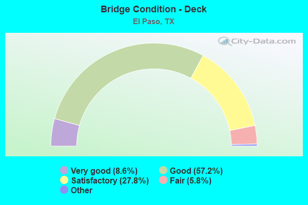
- Bridge Condition - Deck
- 8.6%Excellent
- 57.2%Very good
- 27.8%Good
- 5.8%Satisfactory
- 0.6%Fair
- 0.2%Poor
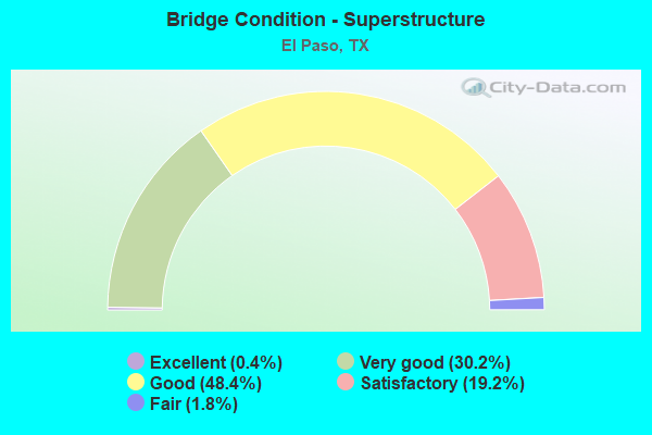
- Bridge Condition - Superstructure
- 0.4%Excellent
- 30.2%Very good
- 48.4%Good
- 19.2%Satisfactory
- 1.8%Fair
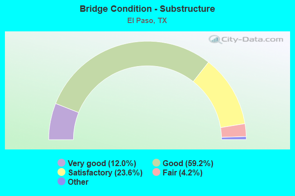
- Bridge Condition - Substructure
- 12.0%Excellent
- 59.2%Very good
- 23.6%Good
- 4.2%Satisfactory
- 1.0%Fair
- 0.6%Poor
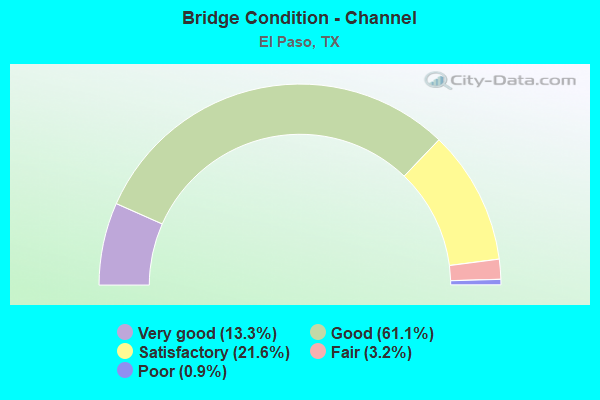
- Bridge Condition - Channel
- 13.3%Very good
- 61.1%Good
- 21.6%Satisfactory
- 3.2%Fair
- 0.9%Poor
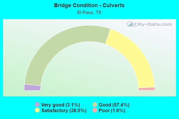
- Bridge Condition - Culverts
- 3.1%Very good
- 57.4%Good
- 38.0%Satisfactory
- 1.6%Poor
Find on map >> Show street view
Structure Number: 240720255203049, Location: 0.3 MI N OF IH 10 (Lat: 31.705531, Lng: -106.280950), Route carried "on" structure: State highway 375, Year Built: 2005, Status: Open, Structure Length: 10.52m (34.51ft), Average Daily Traffic: 45,100 (year 2013), Truck Traffic: 4%, Average Future Daily Traffic: 63,140 (year 2033), Design Load: HS 25 or greater, Features Intersected: ROJAS DRIVE
Minimum Vertical Clearance: 30+ m (98+ ft), Kilometerpoint: 19.296, Lanes on structure: 4, Lanes under structure: 8, Owner: State Highway Agency, Approaching Roadway Width: 33.5m (109.9ft), Skew: 30 degrees, Material/Design: Prestressed concrete, Design/Construction: Stringer/Multi-beam, Number Of Spans In Main Unit: 3, Length of Maximum Span: 35.1m (115.2ft), Curb-To-Curb Width: 33.8m (110.9ft), Out-to-Out Width: 35.4m (116.1ft)
Condition: Deck: Good, Superstructure: Good, Substructure: Good, Operating Rating: 68.0 metric tons, Method Used To Determine Operating Rating: Assigned rating based on Load Factor Design (LFD) reported in metric tons, Inventory Rating: 40.8 metric tons, Method Used To Determine Inventory Rating: Assigned rating based on Load Factor Design (LFD) reported in metric tons, Structural Evaluation: Better than present minimum criteria, Deck Geometry: Superior to present desirable criteria, Underclear: Better than present minimum criteria, Approach Roadway Alignment: Equal to present desirable criteria, Designated Inspection Frequency: Every 24 months, Inspection Date: March 2020, Deck Structure Type: Corrugated Steel, Wearing Surface/Protective System: Wearing Surface: Monolithic Concrete
Find on map >> Show street view
Structure Number: 24072025520305, Location: 1.59 MI N OF IH 10 (Lat: 31.719039, Lng: -106.268936), Route carried "on" structure: State highway 375, Year Built: 2005, Status: Open, Structure Length: 9.54m (31.30ft), Average Daily Traffic: 70,140 (year 2012), Truck Traffic: 11%, Average Future Daily Traffic: 81,000 (year 2030), Design Load: HS 25 or greater, Features Intersected: BOB HOPE DR
Minimum Vertical Clearance: 30+ m (98+ ft), Kilometerpoint: 20.577, Lanes on structure: 4, Lanes under structure: 8, Owner: State Highway Agency, Approaching Roadway Width: 33.5m (109.9ft), Skew: 30 degrees, Material/Design: Prestressed concrete, Design/Construction: Stringer/Multi-beam, Number Of Spans In Main Unit: 3, Length of Maximum Span: 34.1m (111.9ft), Curb-To-Curb Width: 33.5m (109.9ft), Out-to-Out Width: 35.4m (116.1ft)
Condition: Deck: Good, Superstructure: Good, Substructure: Good, Operating Rating: 68.0 metric tons, Method Used To Determine Operating Rating: Assigned rating based on Load Factor Design (LFD) reported in metric tons, Inventory Rating: 40.8 metric tons, Method Used To Determine Inventory Rating: Assigned rating based on Load Factor Design (LFD) reported in metric tons, Structural Evaluation: Better than present minimum criteria, Deck Geometry: Superior to present desirable criteria, Underclear: Better than present minimum criteria, Approach Roadway Alignment: Equal to present desirable criteria, Designated Inspection Frequency: Every 24 months, Inspection Date: March 2020, Deck Structure Type: Concrete Cast-file-Place
Find on map >> Show street view
Structure Number: 240720255203051, Location: 2.00 MI NE OF IH 10 (Lat: 31.726461, Lng: -106.267053), Route carried "on" structure: City street , Year Built: 2005, Status: Open, Structure Length: 5.79m (19.00ft), Average Daily Traffic: 2,000 (year 2018), Truck Traffic: 1%, Average Future Daily Traffic: 3,000 (year 2038), Design Load: HS 25 or greater, Features Intersected: LP 375, Facility Carried by Structure: PELLICANO DR WB
Minimum Vertical Clearance: 30+ m (98+ ft), Kilometerpoint: 0.161, Lanes on structure: 3, Lanes under structure: 4, Owner: State Highway Agency, Approaching Roadway Width: 9.8m (32.2ft), Skew: 20 degrees, Material/Design: Prestressed concrete, Design/Construction: Stringer/Multi-beam, Number Of Spans In Main Unit: 2, Length of Maximum Span: 29.0m (95.1ft), Curb or Sidewalk Widths: Left: 1.7m (5.6ft), Right: 0.0m, Curb-To-Curb Width: 15.2m (49.9ft), Out-to-Out Width: 30.9m (101.4ft)
Condition: Deck: Good, Superstructure: Good, Substructure: Good, Operating Rating: 68.0 metric tons, Method Used To Determine Operating Rating: Assigned rating based on Load Factor Design (LFD) reported in metric tons, Inventory Rating: 40.8 metric tons, Method Used To Determine Inventory Rating: Assigned rating based on Load Factor Design (LFD) reported in metric tons, Structural Evaluation: Better than present minimum criteria, Deck Geometry: Equal to present minimum criteria, Underclear: Equal to present minimum criteria, Approach Roadway Alignment: Equal to present desirable criteria, Designated Inspection Frequency: Every 24 months, Inspection Date: March 2020, Deck Structure Type: Concrete Cast-file-Place
Find on map >> Show street view
Structure Number: 24072025520309, Location: LOOP 375 AT NORTH LOOP (Lat: 31.686431, Lng: -106.298736), Route carried "on" structure: State highway 375, Year Built: 2000, Status: Open, Structure Length: 9.00m (29.53ft), Average Daily Traffic: 22,550 (year 2013), Truck Traffic: 4%, Average Future Daily Traffic: 31,570 (year 2033), Design Load: HS 25 or greater, Features Intersected: NORTH LOOP
Minimum Vertical Clearance: 30+ m (98+ ft), Kilometerpoint: 21.889, Lanes on structure: 2, Lanes under structure: 8, Owner: State Highway Agency, Approaching Roadway Width: 12.2m (40.0ft), Material/Design: Prestressed concrete, Design/Construction: Stringer/Multi-beam, Number Of Spans In Main Unit: 2, Number Of Approach Spans: 1, Length of Maximum Span: 37.0m (121.4ft), Curb-To-Curb Width: 11.2m (36.7ft), Out-to-Out Width: 12.0m (39.4ft)
Condition: Deck: Good, Superstructure: Good, Substructure: Good, Operating Rating: 68.0 metric tons, Method Used To Determine Operating Rating: Assigned rating based on Load Factor Design (LFD) reported in metric tons, Inventory Rating: 40.8 metric tons, Method Used To Determine Inventory Rating: Assigned rating based on Load Factor Design (LFD) reported in metric tons, Structural Evaluation: Better than present minimum criteria, Deck Geometry: Somewhat better than minimum adequacy, Underclear: Equal to present minimum criteria, Approach Roadway Alignment: Equal to present desirable criteria, Designated Inspection Frequency: Every 24 months, Inspection Date: March 2020, Deck Structure Type: Concrete Precast Panels
Find on map >> Show street view
Structure Number: 240720255203091, Location: LOOP 375 AT NORTH LOOP (Lat: 31.687086, Lng: -106.298228), Route carried "on" structure: State highway 375, Year Built: 2000, Status: Open, Structure Length: 9.00m (29.53ft), Average Daily Traffic: 22,550 (year 2013), Truck Traffic: 4%, Average Future Daily Traffic: 31,570 (year 2033), Design Load: HS 25 or greater, Features Intersected: NORTH LOOP
Minimum Vertical Clearance: 30+ m (98+ ft), Kilometerpoint: 21.889, Lanes on structure: 2, Lanes under structure: 8, Owner: State Highway Agency, Approaching Roadway Width: 12.2m (40.0ft), Material/Design: Prestressed concrete, Design/Construction: Stringer/Multi-beam, Number Of Spans In Main Unit: 2, Number Of Approach Spans: 1, Length of Maximum Span: 37.0m (121.4ft), Curb-To-Curb Width: 11.2m (36.7ft), Out-to-Out Width: 12.0m (39.4ft)
Condition: Deck: Good, Superstructure: Good, Substructure: Good, Operating Rating: 68.0 metric tons, Method Used To Determine Operating Rating: Assigned rating based on Load Factor Design (LFD) reported in metric tons, Inventory Rating: 40.8 metric tons, Method Used To Determine Inventory Rating: Assigned rating based on Load Factor Design (LFD) reported in metric tons, Structural Evaluation: Better than present minimum criteria, Deck Geometry: Somewhat better than minimum adequacy, Underclear: Equal to present minimum criteria, Approach Roadway Alignment: Equal to present desirable criteria, Designated Inspection Frequency: Every 24 months, Inspection Date: March 2020, Deck Structure Type: Concrete Precast Panels
Find on map >> Show street view
Structure Number: 240720255203092, Location: LOOP 375 AT PAN AMERICAN (Lat: 31.676006, Lng: -106.323844), Route carried "on" structure: State highway 375, Year Built: 2000, Status: Open, Structure Length: 8.35m (27.40ft), Average Daily Traffic: 14,982 (year 2019), Truck Traffic: 4%, Average Future Daily Traffic: 18,410 (year 2033), Design Load: HS 25 or greater, Features Intersected: PAN AMERICAN DR
Minimum Vertical Clearance: 30+ m (98+ ft), Kilometerpoint: 24.488, Lanes on structure: 2, Lanes under structure: 6, Owner: State Highway Agency, Approaching Roadway Width: 12.2m (40.0ft), Material/Design: Prestressed concrete, Design/Construction: Stringer/Multi-beam, Number Of Spans In Main Unit: 1, Number Of Approach Spans: 2, Length of Maximum Span: 33.5m (109.9ft), Curb-To-Curb Width: 11.2m (36.7ft), Out-to-Out Width: 12.0m (39.4ft)
Condition: Deck: Good, Superstructure: Good, Substructure: Good, Operating Rating: 68.0 metric tons, Method Used To Determine Operating Rating: Assigned rating based on Load Factor Design (LFD) reported in metric tons, Inventory Rating: 40.8 metric tons, Method Used To Determine Inventory Rating: Assigned rating based on Load Factor Design (LFD) reported in metric tons, Structural Evaluation: Better than present minimum criteria, Deck Geometry: Somewhat better than minimum adequacy, Underclear: Meets minimum limits, Approach Roadway Alignment: Equal to present desirable criteria, Designated Inspection Frequency: Every 24 months, Inspection Date: March 2020, Deck Structure Type: Concrete Precast Panels
Find on map >> Show street view
Structure Number: 240720255203093, Location: LOOP 375 AT PAN AMERICAN (Lat: 31.676442, Lng: -106.323086), Route carried "on" structure: State highway 375, Year Built: 2000, Status: Open, Structure Length: 8.35m (27.40ft), Average Daily Traffic: 16,343 (year 2019), Truck Traffic: 4%, Average Future Daily Traffic: 18,410 (year 2033), Design Load: HS 25 or greater, Features Intersected: PAN AMERICAN DR
Minimum Vertical Clearance: 30+ m (98+ ft), Kilometerpoint: 24.488, Lanes on structure: 2, Lanes under structure: 6, Owner: State Highway Agency, Approaching Roadway Width: 12.2m (40.0ft), Material/Design: Prestressed concrete, Design/Construction: Stringer/Multi-beam, Number Of Spans In Main Unit: 1, Number Of Approach Spans: 2, Length of Maximum Span: 33.5m (109.9ft), Curb-To-Curb Width: 11.2m (36.7ft), Out-to-Out Width: 12.0m (39.4ft)
Condition: Deck: Good, Superstructure: Good, Substructure: Good, Operating Rating: 68.0 metric tons, Method Used To Determine Operating Rating: Assigned rating based on Load Factor Design (LFD) reported in metric tons, Inventory Rating: 40.8 metric tons, Method Used To Determine Inventory Rating: Assigned rating based on Load Factor Design (LFD) reported in metric tons, Structural Evaluation: Better than present minimum criteria, Deck Geometry: Somewhat better than minimum adequacy, Underclear: Meets minimum limits, Approach Roadway Alignment: Equal to present desirable criteria, Designated Inspection Frequency: Every 24 months, Inspection Date: March 2020, Deck Structure Type: Concrete Precast Panels
Find on map >> Show street view
Structure Number: 240720255203185, Location: LOOP 375 AT SOCORRO AVE (Lat: 31.678039, Lng: -106.316828), Route carried "on" structure: State highway 375, Year Built: 2000, Status: Open, Structure Length: 8.50m (27.89ft), Average Daily Traffic: 13,150 (year 2013), Truck Traffic: 4%, Average Future Daily Traffic: 18,410 (year 2033), Design Load: HS 25 or greater, Features Intersected: SOCORRO AVE
Minimum Vertical Clearance: 30+ m (98+ ft), Kilometerpoint: 25.212, Lanes on structure: 2, Lanes under structure: 5, Owner: State Highway Agency, Approaching Roadway Width: 12.2m (40.0ft), Material/Design: Prestressed concrete, Design/Construction: Stringer/Multi-beam, Number Of Spans In Main Unit: 1, Number Of Approach Spans: 2, Length of Maximum Span: 35.0m (114.8ft), Curb-To-Curb Width: 11.2m (36.7ft), Out-to-Out Width: 12.0m (39.4ft)
Condition: Deck: Good, Superstructure: Good, Substructure: Good, Operating Rating: 68.0 metric tons, Method Used To Determine Operating Rating: Assigned rating based on Load Factor Design (LFD) reported in metric tons, Inventory Rating: 40.8 metric tons, Method Used To Determine Inventory Rating: Assigned rating based on Load Factor Design (LFD) reported in metric tons, Structural Evaluation: Better than present minimum criteria, Deck Geometry: Somewhat better than minimum adequacy, Underclear: Equal to present minimum criteria, Approach Roadway Alignment: Equal to present desirable criteria, Designated Inspection Frequency: Every 24 months, Inspection Date: March 2020, Deck Structure Type: Concrete Precast Panels
Find on map >> Show street view
Structure Number: 240720255203186, Location: LOOP 375 AT SOCORRO AVE (Lat: 31.678650, Lng: -106.316236), Route carried "on" structure: State highway 375, Year Built: 2000, Status: Open, Structure Length: 8.50m (27.89ft), Average Daily Traffic: 13,150 (year 2013), Truck Traffic: 4%, Average Future Daily Traffic: 18,410 (year 2033), Design Load: HS 25 or greater, Features Intersected: SOCORRO AVE
Minimum Vertical Clearance: 30+ m (98+ ft), Kilometerpoint: 25.212, Lanes on structure: 2, Lanes under structure: 5, Owner: State Highway Agency, Approaching Roadway Width: 12.2m (40.0ft), Material/Design: Prestressed concrete, Design/Construction: Stringer/Multi-beam, Number Of Spans In Main Unit: 1, Number Of Approach Spans: 2, Length of Maximum Span: 35.0m (114.8ft), Curb-To-Curb Width: 11.2m (36.7ft), Out-to-Out Width: 12.0m (39.4ft)
Condition: Deck: Good, Superstructure: Good, Substructure: Good, Operating Rating: 68.0 metric tons, Method Used To Determine Operating Rating: Assigned rating based on Load Factor Design (LFD) reported in metric tons, Inventory Rating: 40.8 metric tons, Method Used To Determine Inventory Rating: Assigned rating based on Load Factor Design (LFD) reported in metric tons, Structural Evaluation: Better than present minimum criteria, Deck Geometry: Somewhat better than minimum adequacy, Underclear: Equal to present minimum criteria, Approach Roadway Alignment: Equal to present desirable criteria, Designated Inspection Frequency: Every 24 months, Inspection Date: March 2020, Deck Structure Type: Concrete Precast Panels
Find on map >> Show street view
Structure Number: 24072025520327, Location: LP 375 AT EDGEMERE BLVD (Lat: 31.792647, Lng: -106.268250), Route carried "on" structure: State highway 375, Year Built: 2006, Status: Open, Structure Length: 7.89m (25.89ft), Average Daily Traffic: 39,278 (year 2020), Truck Traffic: 12%, Average Future Daily Traffic: 45,200 (year 2031), Design Load: HS 25 or greater, Features Intersected: EDGEMERE BLVD
Minimum Vertical Clearance: 30+ m (98+ ft), Kilometerpoint: 42.364, Lanes on structure: 6, Lanes under structure: 8, Base Highway Network: Yes, Owner: State Highway Agency, Approaching Roadway Width: 34.1m (111.9ft), Skew: 30 degrees, Material/Design: Prestressed concrete, Design/Construction: Stringer/Multi-beam, Number Of Spans In Main Unit: 1, Number Of Approach Spans: 2, Length of Maximum Span: 36.3m (119.1ft), Curb-To-Curb Width: 34.1m (111.9ft), Out-to-Out Width: 36.3m (119.1ft)
Condition: Deck: Good, Superstructure: Very good, Substructure: Good, Operating Rating: 68.0 metric tons, Method Used To Determine Operating Rating: Assigned rating based on Load Factor Design (LFD) reported in metric tons, Inventory Rating: 40.8 metric tons, Method Used To Determine Inventory Rating: Assigned rating based on Load Factor Design (LFD) reported in metric tons, Structural Evaluation: Better than present minimum criteria, Deck Geometry: Superior to present desirable criteria, Underclear: Superior to present desirable criteria, Approach Roadway Alignment: Equal to present desirable criteria, Designated Inspection Frequency: Every 24 months, Inspection Date: July 2021, Deck Structure Type: Concrete Cast-file-Place
Find on map >> Show street view
Structure Number: 240720255203271, Location: 4.5 MI S OF US 62 (Lat: 31.741361, Lng: -106.267703), Route carried "on" structure: State highway 375, Year Built: 2006, Status: Open, Structure Length: 7.89m (25.89ft), Average Daily Traffic: 24,300 (year 2011), Truck Traffic: 12%, Average Future Daily Traffic: 45,200 (year 2031), Design Load: HS 25 or greater, Features Intersected: VISTA DEL SOL DR
Minimum Vertical Clearance: 5.11m (16.77ft), Kilometerpoint: 48.079, Lanes on structure: 6, Lanes under structure: 8, Base Highway Network: Yes, Owner: State Highway Agency, Approaching Roadway Width: 34.7m (113.8ft), Skew: 30 degrees, Material/Design: Prestressed concrete, Design/Construction: Stringer/Multi-beam, Number Of Spans In Main Unit: 1, Number Of Approach Spans: 2, Length of Maximum Span: 36.3m (119.1ft), Curb-To-Curb Width: 34.7m (113.8ft), Out-to-Out Width: 36.3m (119.1ft)
Condition: Deck: Good, Superstructure: Good, Substructure: Good, Operating Rating: 68.0 metric tons, Method Used To Determine Operating Rating: Assigned rating based on Load Factor Design (LFD) reported in metric tons, Inventory Rating: 40.8 metric tons, Method Used To Determine Inventory Rating: Assigned rating based on Load Factor Design (LFD) reported in metric tons, Structural Evaluation: Better than present minimum criteria, Deck Geometry: Superior to present desirable criteria, Underclear: Superior to present desirable criteria, Approach Roadway Alignment: Equal to present desirable criteria, Designated Inspection Frequency: Every 24 months, Inspection Date: August 2021, Deck Structure Type: Concrete Cast-file-Place
Find on map >> Show street view
Structure Number: 240720255203272, Location: 2.00 MI NE OF IH 10 (Lat: 31.725875, Lng: -106.267594), Route carried "on" structure: Other road 2, Year Built: 2005, Status: Open, Structure Length: 5.79m (19.00ft), Average Daily Traffic: 2,000 (year 2018), Truck Traffic: 1%, Average Future Daily Traffic: 3,000 (year 2038), Design Load: HS 25 or greater, Features Intersected: LP 375, Facility Carried by Structure: PELLICANO DR EB
Minimum Vertical Clearance: 30+ m (98+ ft), Kilometerpoint: 0.161, Lanes on structure: 3, Lanes under structure: 4, Owner: State Highway Agency, Approaching Roadway Width: 9.8m (32.2ft), Skew: 20 degrees, Material/Design: Prestressed concrete, Design/Construction: Stringer/Multi-beam, Number Of Spans In Main Unit: 2, Length of Maximum Span: 29.0m (95.1ft), Curb or Sidewalk Widths: Left: 0.0m, Right: 1.7m (5.6ft), Curb-To-Curb Width: 15.2m (49.9ft), Out-to-Out Width: 30.9m (101.4ft)
Condition: Deck: Good, Superstructure: Good, Substructure: Good, Operating Rating: 68.0 metric tons, Method Used To Determine Operating Rating: Assigned rating based on Load Factor Design (LFD) reported in metric tons, Inventory Rating: 38.1 metric tons, Method Used To Determine Inventory Rating: Assigned rating based on Load Factor Design (LFD) reported in metric tons, Structural Evaluation: Better than present minimum criteria, Deck Geometry: Equal to present minimum criteria, Underclear: Equal to present minimum criteria, Approach Roadway Alignment: Equal to present desirable criteria, Designated Inspection Frequency: Every 24 months, Inspection Date: March 2020, Deck Structure Type: Concrete Cast-file-Place
Find on map >> Show street view
Structure Number: 240720255203273, Location: 3.1 MI S OF US 62 (Lat: 31.761033, Lng: -106.267925), Route carried "on" structure: State highway 375, Year Built: 2006, Status: Open, Structure Length: 7.89m (25.89ft), Average Daily Traffic: 65,790 (year 2013), Truck Traffic: 6%, Average Future Daily Traffic: 92,110 (year 2033), Design Load: HS 25 or greater, Features Intersected: MONTWOOD DR
Minimum Vertical Clearance: 5.36m (17.59ft), Kilometerpoint: 13.015, Lanes on structure: 6, Lanes under structure: 10, Base Highway Network: Yes, Owner: State Highway Agency, Approaching Roadway Width: 34.7m (113.8ft), Skew: 30 degrees, Material/Design: Prestressed concrete, Design/Construction: Stringer/Multi-beam, Number Of Spans In Main Unit: 1, Number Of Approach Spans: 2, Length of Maximum Span: 36.3m (119.1ft), Curb-To-Curb Width: 34.7m (113.8ft), Out-to-Out Width: 36.3m (119.1ft)
Condition: Deck: Good, Superstructure: Good, Substructure: Good, Operating Rating: 68.0 metric tons, Method Used To Determine Operating Rating: Assigned rating based on Load Factor Design (LFD) reported in metric tons, Inventory Rating: 40.8 metric tons, Method Used To Determine Inventory Rating: Assigned rating based on Load Factor Design (LFD) reported in metric tons, Structural Evaluation: Better than present minimum criteria, Deck Geometry: Superior to present desirable criteria, Underclear: Superior to present desirable criteria, Approach Roadway Alignment: Equal to present desirable criteria, Designated Inspection Frequency: Every 24 months, Inspection Date: August 2021, Deck Structure Type: Concrete Cast-file-Place
Find on map >> Show street view
Structure Number: 240720255203274, Location: 2.1 MI S OF US 62 (Lat: 31.776694, Lng: -106.268111), Route carried "on" structure: State highway 375, Year Built: 2006, Status: Open, Structure Length: 7.89m (25.89ft), Average Daily Traffic: 39,278 (year 2020), Truck Traffic: 12%, Average Future Daily Traffic: 45,200 (year 2027), Design Load: HS 25 or greater, Features Intersected: PEBBLE HILLS BLVD
Minimum Vertical Clearance: 5.08m (16.67ft), Kilometerpoint: 44.160, Lanes on structure: 4, Lanes under structure: 8, Base Highway Network: Yes, Owner: State Highway Agency, Approaching Roadway Width: 34.7m (113.8ft), Skew: 30 degrees, Material/Design: Prestressed concrete, Design/Construction: Stringer/Multi-beam, Number Of Spans In Main Unit: 1, Number Of Approach Spans: 2, Length of Maximum Span: 36.3m (119.1ft), Curb-To-Curb Width: 34.7m (113.8ft), Out-to-Out Width: 36.3m (119.1ft)
Condition: Deck: Good, Superstructure: Good, Substructure: Good, Operating Rating: 68.0 metric tons, Method Used To Determine Operating Rating: Assigned rating based on Load Factor Design (LFD) reported in metric tons, Inventory Rating: 40.8 metric tons, Method Used To Determine Inventory Rating: Assigned rating based on Load Factor Design (LFD) reported in metric tons, Structural Evaluation: Better than present minimum criteria, Deck Geometry: Superior to present desirable criteria, Underclear: Superior to present desirable criteria, Approach Roadway Alignment: Equal to present desirable criteria, Designated Inspection Frequency: Every 24 months, Inspection Date: August 2021, Deck Structure Type: Concrete Cast-file-Place
Find on map >> Show street view
Structure Number: 240720255203275, Location: 3.0 MI S OF US 62 (Lat: 31.762950, Lng: -106.267994), Route carried "on" structure: State highway 375, Year Built: 2006, Status: Open, Structure Length: 4.11m (13.48ft), Average Daily Traffic: 69,491 (year 2020), Truck Traffic: 6%, Average Future Daily Traffic: 92,110 (year 2033), Design Load: HS 25 or greater, Features Intersected: ZARAGOSA (FM 659)
Minimum Vertical Clearance: 30+ m (98+ ft), Kilometerpoint: 12.806, Lanes on structure: 6, Lanes under structure: 6, Base Highway Network: Yes, Owner: State Highway Agency, Approaching Roadway Width: 34.6m (113.5ft), Skew: 30 degrees, Material/Design: Steel, Design/Construction: Stringer/Multi-beam, Number Of Spans In Main Unit: 1, Length of Maximum Span: 41.1m (134.8ft), Curb-To-Curb Width: 34.6m (113.5ft), Out-to-Out Width: 36.3m (119.1ft)
Condition: Deck: Good, Superstructure: Good, Substructure: Good, Operating Rating: 68.0 metric tons, Method Used To Determine Operating Rating: Assigned rating based on Load Factor Design (LFD) reported in metric tons, Inventory Rating: 40.8 metric tons, Method Used To Determine Inventory Rating: Assigned rating based on Load Factor Design (LFD) reported in metric tons, Structural Evaluation: Better than present minimum criteria, Deck Geometry: Superior to present desirable criteria, Underclear: Equal to present minimum criteria, Approach Roadway Alignment: Equal to present desirable criteria, Designated Inspection Frequency: Every 24 months, Inspection Date: August 2021, Deck Structure Type: Concrete Cast-file-Place
Find on map >> Show street view
Structure Number: 24072025520329, Location: LP 375 & FM 659 I/C (Lat: 31.759172, Lng: -106.267503), Route carried "on" structure: Ramp State highway 375, Year Built: 2013, Status: Open, Structure Length: 78.97m (259.09ft), Average Daily Traffic: 9,392 (year 2017), Truck Traffic: 5%, Average Future Daily Traffic: 100 (year 2034), Design Load: HL 93, Features Intersected: FM 659 (ZARAGOZA)
Minimum Vertical Clearance: 30+ m (98+ ft), Kilometerpoint: 46.172, Lanes on structure: 1, Lanes under structure: 16, Owner: State Highway Agency, Approaching Roadway Width: 7.9m (25.9ft), Material/Design: Steel continuous, Design/Construction: Stringer/Multi-beam, Number Of Spans In Main Unit: 3, Number Of Approach Spans: 18, Length of Maximum Span: 73.5m (241.1ft), Curb-To-Curb Width: 7.9m (25.9ft), Out-to-Out Width: 8.5m (27.9ft)
Condition: Deck: Good, Superstructure: Good, Substructure: Good, Operating Rating: 54.4 metric tons, Method Used To Determine Operating Rating: Assigned ratings based on Load and Resistance Factor Design (LRFD) reported in metric tons, Inventory Rating: 32.7 metric tons, Method Used To Determine Inventory Rating: Assigned ratings based on Load and Resistance Factor Design (LRFD) reported in metric tons, Structural Evaluation: Better than present minimum criteria, Deck Geometry: Equal to present desirable criteria, Underclear: Somewhat better than minimum adequacy, Approach Roadway Alignment: Equal to present desirable criteria, Designated Inspection Frequency: Every 24 months, Inspection Date: March 2020, Deck Structure Type: Concrete Cast-file-Place
Find on map >> Show street view
Structure Number: 240720255203291, Location: LP 375 & FM 659 I/C (Lat: 31.764903, Lng: -106.264678), Route carried "on" structure: Ramp State highway 659, Year Built: 2013, Status: Open, Structure Length: 75.59m (248.00ft), Average Daily Traffic: 2,000 (year 2018), Truck Traffic: 5%, Average Future Daily Traffic: 2,500 (year 2038), Design Load: HL 93, Features Intersected: LP 375
Minimum Vertical Clearance: 30+ m (98+ ft), Kilometerpoint: 7.323, Lanes on structure: 1, Lanes under structure: 19, Owner: State Highway Agency, Approaching Roadway Width: 7.9m (25.9ft), Material/Design: Steel continuous, Design/Construction: Stringer/Multi-beam, Number Of Spans In Main Unit: 3, Number Of Approach Spans: 16, Length of Maximum Span: 73.5m (241.1ft), Curb-To-Curb Width: 7.9m (25.9ft), Out-to-Out Width: 8.5m (27.9ft)
Condition: Deck: Good, Superstructure: Very good, Substructure: Good, Operating Rating: 54.4 metric tons, Method Used To Determine Operating Rating: Assigned ratings based on Load and Resistance Factor Design (LRFD) reported in metric tons, Inventory Rating: 32.7 metric tons, Method Used To Determine Inventory Rating: Assigned ratings based on Load and Resistance Factor Design (LRFD) reported in metric tons, Structural Evaluation: Better than present minimum criteria, Deck Geometry: Equal to present desirable criteria, Underclear: High priority of corrective action, Approach Roadway Alignment: Equal to present desirable criteria, Designated Inspection Frequency: Every 24 months, Inspection Date: March 2020, Deck Structure Type: Concrete Cast-file-Place
Find on map >> Show street view
Structure Number: 240720255204012, Location: 1.1 MI W CORDOVA INT BR (Lat: 31.759039, Lng: -106.469250), Route carried "on" structure: State highway 375, Year Built: 1972, Status: Open, Structure Length: 31.82m (104.40ft), Average Daily Traffic: 9,530 (year 2013), Truck Traffic: 4%, Average Future Daily Traffic: 13,340 (year 2033), Design Load: HS 20, Features Intersected: UP RR & FRANKLIN CANAL
Minimum Vertical Clearance: 30+ m (98+ ft), Kilometerpoint: 17.655, Lanes on structure: 3, Base Highway Network: Yes, Owner: State Highway Agency, Approaching Roadway Width: 15.2m (49.9ft), Skew: 9 degrees, Material/Design: Prestressed concrete, Design/Construction: Stringer/Multi-beam, Number Of Spans In Main Unit: 3, Number Of Approach Spans: 11, Length of Maximum Span: 33.2m (108.9ft), Curb-To-Curb Width: 15.3m (50.2ft), Out-to-Out Width: 15.5m (50.9ft)
Condition: Deck: Good, Superstructure: Good, Substructure: Good, Operating Rating: 54.4 metric tons, Method Used To Determine Operating Rating: Assigned rating based on Load Factor Design (LFD) reported in metric tons, Inventory Rating: 32.7 metric tons, Method Used To Determine Inventory Rating: Assigned rating based on Load Factor Design (LFD) reported in metric tons, Structural Evaluation: Better than present minimum criteria, Deck Geometry: Meets minimum limits, Underclear: Somewhat better than minimum adequacy, Approach Roadway Alignment: Equal to present desirable criteria, Designated Inspection Frequency: Every 24 months, Inspection Date: May 2021, Deck Structure Type: Concrete Cast-file-Place, Wearing Surface/Protective System: Wearing Surface: Bituminous
Find on map >> Show street view
Structure Number: 240720255204013, Location: 1.5 MI W CORDOVA INT BR (Lat: 31.756833, Lng: -106.470417), Route carried "on" structure: State highway 375, Year Built: 1972, Status: Open, Structure Length: 27.74m (91.01ft), Average Daily Traffic: 9,530 (year 2013), Truck Traffic: 4%, Average Future Daily Traffic: 13,340 (year 2033), Design Load: HS 20, Features Intersected: OLD ABANDONED RAIL BED
Minimum Vertical Clearance: 30+ m (98+ ft), Kilometerpoint: 18.693, Lanes on structure: 2, Base Highway Network: Yes, Owner: State Highway Agency, Approaching Roadway Width: 11.6m (38.1ft), Skew: 9 degrees, Material/Design: Prestressed concrete, Design/Construction: Stringer/Multi-beam, Number Of Spans In Main Unit: 11, Number Of Approach Spans: 1, Length of Maximum Span: 26.5m (86.9ft), Curb-To-Curb Width: 11.6m (38.1ft), Out-to-Out Width: 12.1m (39.7ft)
Condition: Deck: Good, Superstructure: Good, Substructure: Good, Operating Rating: 54.4 metric tons, Method Used To Determine Operating Rating: Assigned rating based on Load Factor Design (LFD) reported in metric tons, Inventory Rating: 32.7 metric tons, Method Used To Determine Inventory Rating: Assigned rating based on Load Factor Design (LFD) reported in metric tons, Structural Evaluation: Better than present minimum criteria, Deck Geometry: Equal to present minimum criteria, Approach Roadway Alignment: Equal to present desirable criteria, Designated Inspection Frequency: Every 24 months, Inspection Date: August 2021, Deck Structure Type: Concrete Cast-file-Place, Wearing Surface/Protective System: Wearing Surface: Bituminous
Find on map >> Show street view
Structure Number: 240720255204014, Location: 200FT W CORDOVA INTNL BR (Lat: 31.765308, Lng: -106.452031), Route carried "on" structure: State highway 375, Year Built: 1968, Status: Open, Structure Length: 0.82m (2.69ft), Average Daily Traffic: 18,991 (year 2019), Truck Traffic: 4%, Average Future Daily Traffic: 46,810 (year 2033), Design Load: HS 20, Features Intersected: CEBADA DRAIN
Minimum Vertical Clearance: 30+ m (98+ ft), Kilometerpoint: 16.163, Lanes on structure: 10, Owner: State Highway Agency, Approaching Roadway Width: 46.0m (150.9ft), Skew: 30 degrees, Material/Design: Concrete, Design/Construction: Culvert, Number Of Spans In Main Unit: 4, Length of Maximum Span: 1.8m (5.9ft)
Condition: Channel: Good, Culverts: Good, Operating Rating: 44.4 metric tons, Method Used To Determine Operating Rating: No rating analysis performed, Inventory Rating: 32.7 metric tons, Method Used To Determine Inventory Rating: No rating analysis performed, Structural Evaluation: Better than present minimum criteria, Waterway Adequacy: Equal to present minimum criteria, Approach Roadway Alignment: Equal to present desirable criteria, Designated Inspection Frequency: Every 24 months, Inspection Date: July 2021
Find on map >> Show street view
Structure Number: 240720255204019, Location: 6.6 MI W OF FM 659 (Lat: 31.745550, Lng: -106.403292), Route carried "on" structure: State highway 375, Year Built: 1976, Status: Open, Structure Length: 0.70m (2.30ft), Average Daily Traffic: 39,280 (year 2020), Truck Traffic: 4%, Average Future Daily Traffic: 48,270 (year 2033), Design Load: HS 20, Features Intersected: ASCARATE WASTEWAY
Minimum Vertical Clearance: 30+ m (98+ ft), Kilometerpoint: 11.026, Lanes on structure: 6, Owner: State Highway Agency, Approaching Roadway Width: 25.6m (84.0ft), Skew: 30 degrees, Material/Design: Concrete, Design/Construction: Culvert, Number Of Spans In Main Unit: 4, Length of Maximum Span: 1.5m (4.9ft), Curb-To-Curb Width: 25.6m (84.0ft), Out-to-Out Width: 79.2m (259.8ft)
Condition: Channel: Good, Culverts: Satisfactory, Operating Rating: 39.9 metric tons, Method Used To Determine Operating Rating: Load Factor (LF), Inventory Rating: 23.6 metric tons, Method Used To Determine Inventory Rating: Load Factor (LF), Structural Evaluation: Somewhat better than minimum adequacy, Deck Geometry: Meets minimum limits, Waterway Adequacy: Equal to present minimum criteria, Approach Roadway Alignment: Equal to present desirable criteria, Designated Inspection Frequency: Every 48 months, Inspection Date: July 2021, Deck Structure Type: Concrete Cast-file-Place, Wearing Surface/Protective System: Wearing Surface: Monolithic Concrete
Find on map >> Show street view
Structure Number: 240720255204022, Location: EL PASO ST & MEXICO BORD (Lat: 31.747719, Lng: -106.486933), Route carried "on" structure: City street , Year Built: 1967, Status: Open, Structure Length: 29.93m (98.20ft), Average Daily Traffic: 14,586 (year 2011), Average Future Daily Traffic: 14,636 (year 2031), Design Load: HS 20, Features Intersected: LOOP-375/RIO GRANDE, Facility Carried by Structure: EL PASO ST.
Minimum Vertical Clearance: 30+ m (98+ ft), Kilometerpoint: 0.805, Lanes on structure: 4, Lanes under structure: 4, Toll: Toll bridge, Owner: City or Municipal Highway Agency, Approaching Roadway Width: 18.9m (62.0ft), Material/Design: Prestressed concrete, Design/Construction: Stringer/Multi-beam, Number Of Spans In Main Unit: 10, Number Of Approach Spans: 6, Length of Maximum Span: 22.9m (75.1ft), Curb or Sidewalk Widths: Left: 2.0m (6.6ft), Right: 2.0m (6.6ft), Curb-To-Curb Width: 13.4m (44.0ft), Out-to-Out Width: 18.9m (62.0ft)
Condition: Deck: Satisfactory, Superstructure: Good, Substructure: Fair, Channel: Good, Operating Rating: 44.4 metric tons, Method Used To Determine Operating Rating: Assigned rating based on Load Factor Design (LFD) reported in metric tons, Inventory Rating: 32.7 metric tons, Method Used To Determine Inventory Rating: Assigned rating based on Load Factor Design (LFD) reported in metric tons, Structural Evaluation: Somewhat better than minimum adequacy, Deck Geometry: High priority of replacement, Underclear: Meets minimum limits, Waterway Adequacy: Equal to present desirable criteria, Approach Roadway Alignment: Equal to present desirable criteria, Length Of Structure Improvement: 29.93m (98.20ft), Designated Inspection Frequency: Every 24 months, Inspection Date: December 2020, Bridge Improvement Cost: $86,000, Roadway Improvement Cost: $22,000, Total Project Cost: $108,000, Deck Structure Type: Concrete Cast-file-Place
Find on map >> Show street view
Structure Number: 240720255204023, Location: AT STANTON ST & MEXICO BO (Lat: 31.748400, Lng: -106.482622), Route carried "on" structure: City street , Year Built: 1967, Status: Open, Structure Length: 26.82m (87.99ft), Average Daily Traffic: 14,586 (year 2011), Average Future Daily Traffic: 14,636 (year 2031), Design Load: HS 20, Features Intersected: LOOP-375/RIO GRANDE, Facility Carried by Structure: STANTON ST.
Minimum Vertical Clearance: 30+ m (98+ ft), Kilometerpoint: 0.805, Lanes on structure: 3, Lanes under structure: 4, Base Highway Network: Yes, Toll: Toll bridge, Owner: City or Municipal Highway Agency, Approaching Roadway Width: 13.4m (44.0ft), Material/Design: Prestressed concrete, Design/Construction: Stringer/Multi-beam, Number Of Spans In Main Unit: 10, Number Of Approach Spans: 4, Length of Maximum Span: 21.3m (69.9ft), Curb or Sidewalk Widths: Left: 2.0m (6.6ft), Right: 2.0m (6.6ft), Curb-To-Curb Width: 13.4m (44.0ft), Out-to-Out Width: 18.9m (62.0ft)
Condition: Deck: Satisfactory, Superstructure: Very good, Substructure: Satisfactory, Channel: Good, Operating Rating: 44.4 metric tons, Method Used To Determine Operating Rating: Assigned rating based on Load Factor Design (LFD) reported in metric tons, Inventory Rating: 32.7 metric tons, Method Used To Determine Inventory Rating: Assigned rating based on Load Factor Design (LFD) reported in metric tons, Structural Evaluation: Equal to present minimum criteria, Deck Geometry: Somewhat better than minimum adequacy, Underclear: Somewhat better than minimum adequacy, Waterway Adequacy: Equal to present desirable criteria, Approach Roadway Alignment: Equal to present desirable criteria, Length Of Structure Improvement: 26.82m (87.99ft), Designated Inspection Frequency: Every 24 months, Inspection Date: December 2020, Bridge Improvement Cost: $77,000, Roadway Improvement Cost: $19,000, Total Project Cost: $96,000, Deck Structure Type: Concrete Cast-file-Place
Find on map >> Show street view
Structure Number: 240720255204024, Location: 4.7 MI SE OF US 54 (Lat: 31.731569, Lng: -106.378408), Route carried "on" structure: State highway 375, Year Built: 1979, Year Reconstructed: 2012, Status: Open, Structure Length: 5.79m (19.00ft), Average Daily Traffic: 17,240 (year 2013), Truck Traffic: 4%, Average Future Daily Traffic: 24,130 (year 2033), Design Load: HS 20, Features Intersected: MIDWAY DR
Minimum Vertical Clearance: 30+ m (98+ ft), Kilometerpoint: 8.145, Lanes on structure: 3, Lanes under structure: 4, Owner: State Highway Agency, Approaching Roadway Width: 16.8m (55.1ft), Material/Design: Prestressed concrete, Design/Construction: Stringer/Multi-beam, Number Of Spans In Main Unit: 1, Number Of Approach Spans: 2, Length of Maximum Span: 27.4m (89.9ft), Curb-To-Curb Width: 16.8m (55.1ft), Out-to-Out Width: 17.5m (57.4ft)
Condition: Deck: Good, Superstructure: Good, Substructure: Good, Operating Rating: 54.4 metric tons, Method Used To Determine Operating Rating: Assigned rating based on Load Factor Design (LFD) reported in metric tons, Inventory Rating: 32.7 metric tons, Method Used To Determine Inventory Rating: Assigned rating based on Load Factor Design (LFD) reported in metric tons, Structural Evaluation: Better than present minimum criteria, Deck Geometry: Equal to present minimum criteria, Underclear: Meets minimum limits, Approach Roadway Alignment: Equal to present desirable criteria, Designated Inspection Frequency: Every 24 months, Inspection Date: July 2021, Deck Structure Type: Concrete Cast-file-Place, Wearing Surface/Protective System: Wearing Surface: Bituminous
Find on map >> Show street view
Structure Number: 240720255204025, Location: 4.7 MI SE OF US 54 (Lat: 31.731511, Lng: -106.378500), Route carried "on" structure: State highway 375, Year Built: 1979, Year Reconstructed: 2012, Status: Open, Structure Length: 5.79m (19.00ft), Average Daily Traffic: 17,240 (year 2013), Truck Traffic: 4%, Average Future Daily Traffic: 24,130 (year 2033), Design Load: HS 20, Features Intersected: MIDWAY DR
Minimum Vertical Clearance: 30+ m (98+ ft), Kilometerpoint: 8.145, Lanes on structure: 3, Lanes under structure: 4, Owner: State Highway Agency, Approaching Roadway Width: 16.8m (55.1ft), Material/Design: Prestressed concrete, Design/Construction: Stringer/Multi-beam, Number Of Spans In Main Unit: 1, Number Of Approach Spans: 2, Length of Maximum Span: 27.4m (89.9ft), Curb-To-Curb Width: 16.8m (55.1ft), Out-to-Out Width: 17.5m (57.4ft)
Condition: Deck: Good, Superstructure: Good, Substructure: Good, Operating Rating: 54.4 metric tons, Method Used To Determine Operating Rating: Assigned rating based on Load Factor Design (LFD) reported in metric tons, Inventory Rating: 32.7 metric tons, Method Used To Determine Inventory Rating: Assigned rating based on Load Factor Design (LFD) reported in metric tons, Structural Evaluation: Better than present minimum criteria, Deck Geometry: Equal to present minimum criteria, Underclear: Meets minimum limits, Approach Roadway Alignment: Equal to present desirable criteria, Designated Inspection Frequency: Every 24 months, Inspection Date: July 2021, Deck Structure Type: Concrete Cast-file-Place, Wearing Surface/Protective System: Wearing Surface: Bituminous
Find on map >> Show street view
Structure Number: 240720255204026, Location: 6.3 MI SE OF US 54 (Lat: 31.711450, Lng: -106.367808), Route carried "on" structure: State highway 375, Year Built: 1982, Year Reconstructed: 2012, Status: Open, Structure Length: 5.79m (19.00ft), Average Daily Traffic: 17,760 (year 2013), Truck Traffic: 4%, Average Future Daily Traffic: 24,870 (year 2033), Design Load: HS 20, Features Intersected: YARBROUGH DR
Minimum Vertical Clearance: 30+ m (98+ ft), Kilometerpoint: 5.633, Lanes on structure: 3, Lanes under structure: 4, Owner: State Highway Agency, Approaching Roadway Width: 16.8m (55.1ft), Material/Design: Prestressed concrete, Design/Construction: Stringer/Multi-beam, Number Of Spans In Main Unit: 1, Number Of Approach Spans: 2, Length of Maximum Span: 27.4m (89.9ft), Curb-To-Curb Width: 16.7m (54.8ft), Out-to-Out Width: 17.5m (57.4ft)
Condition: Deck: Good, Superstructure: Good, Substructure: Satisfactory, Operating Rating: 54.4 metric tons, Method Used To Determine Operating Rating: Assigned rating based on Load Factor Design (LFD) reported in metric tons, Inventory Rating: 32.7 metric tons, Method Used To Determine Inventory Rating: Assigned rating based on Load Factor Design (LFD) reported in metric tons, Structural Evaluation: Equal to present minimum criteria, Deck Geometry: Equal to present minimum criteria, Underclear: Meets minimum limits, Approach Roadway Alignment: Equal to present desirable criteria, Designated Inspection Frequency: Every 24 months, Inspection Date: July 2021, Deck Structure Type: Concrete Cast-file-Place, Wearing Surface/Protective System: Wearing Surface: Bituminous
Find on map >> Show street view
Structure Number: 240720255204027, Location: 6.3 MI SE OF US 54 (Lat: 31.711369, Lng: -106.367858), Route carried "on" structure: State highway 375, Year Built: 1982, Year Reconstructed: 2012, Status: Open, Structure Length: 5.79m (19.00ft), Average Daily Traffic: 17,760 (year 2013), Truck Traffic: 4%, Average Future Daily Traffic: 24,870 (year 2033), Design Load: HS 20, Features Intersected: YARBROUGH DR
Minimum Vertical Clearance: 30+ m (98+ ft), Kilometerpoint: 5.633, Lanes on structure: 3, Lanes under structure: 4, Owner: State Highway Agency, Approaching Roadway Width: 16.8m (55.1ft), Material/Design: Prestressed concrete, Design/Construction: Stringer/Multi-beam, Number Of Spans In Main Unit: 1, Number Of Approach Spans: 2, Length of Maximum Span: 27.4m (89.9ft), Curb-To-Curb Width: 16.7m (54.8ft), Out-to-Out Width: 17.5m (57.4ft)
Condition: Deck: Good, Superstructure: Good, Substructure: Good, Operating Rating: 54.4 metric tons, Method Used To Determine Operating Rating: Assigned rating based on Load Factor Design (LFD) reported in metric tons, Inventory Rating: 32.7 metric tons, Method Used To Determine Inventory Rating: Assigned rating based on Load Factor Design (LFD) reported in metric tons, Structural Evaluation: Better than present minimum criteria, Deck Geometry: Equal to present minimum criteria, Underclear: Somewhat better than minimum adequacy, Approach Roadway Alignment: Equal to present desirable criteria, Designated Inspection Frequency: Every 24 months, Inspection Date: July 2021, Deck Structure Type: Concrete Cast-file-Place, Wearing Surface/Protective System: Wearing Surface: Bituminous
Find on map >> Show street view
Structure Number: 240720255204028, Location: 1.9 MI SE OF US 54 (Lat: 31.753419, Lng: -106.418122), Route carried "on" structure: State highway 375, Year Built: 1987, Year Reconstructed: 2012, Status: Open, Structure Length: 5.79m (19.00ft), Average Daily Traffic: 17,240 (year 2013), Truck Traffic: 4%, Average Future Daily Traffic: 24,130 (year 2033), Design Load: HS 20, Features Intersected: FONSECA DR
Minimum Vertical Clearance: 30+ m (98+ ft), Kilometerpoint: 12.638, Lanes on structure: 3, Lanes under structure: 4, Owner: State Highway Agency, Approaching Roadway Width: 16.8m (55.1ft), Material/Design: Prestressed concrete, Design/Construction: Box Beam or Girders - Multiple, Number Of Spans In Main Unit: 1, Number Of Approach Spans: 2, Length of Maximum Span: 27.4m (89.9ft), Curb-To-Curb Width: 16.6m (54.5ft), Out-to-Out Width: 17.5m (57.4ft)
Condition: Deck: Very good, Superstructure: Good, Substructure: Good, Operating Rating: 54.4 metric tons, Method Used To Determine Operating Rating: Assigned rating based on Load Factor Design (LFD) reported in metric tons, Inventory Rating: 32.7 metric tons, Method Used To Determine Inventory Rating: Assigned rating based on Load Factor Design (LFD) reported in metric tons, Structural Evaluation: Better than present minimum criteria, Deck Geometry: Equal to present minimum criteria, Underclear: Meets minimum limits, Approach Roadway Alignment: Equal to present desirable criteria, Designated Inspection Frequency: Every 24 months, Inspection Date: July 2021, Deck Structure Type: Other, Wearing Surface/Protective System: Wearing Surface: Bituminous
Find on map >> Show street view
Structure Number: 240720255204029, Location: 1.9 MI SE OF US 54 (Lat: 31.753319, Lng: -106.418131), Route carried "on" structure: State highway 375, Year Built: 1987, Year Reconstructed: 2012, Status: Open, Structure Length: 5.79m (19.00ft), Average Daily Traffic: 17,240 (year 2013), Truck Traffic: 4%, Average Future Daily Traffic: 24,130 (year 2033), Design Load: HS 20, Features Intersected: FONSECA DR
Minimum Vertical Clearance: 30+ m (98+ ft), Kilometerpoint: 12.638, Lanes on structure: 3, Lanes under structure: 4, Owner: State Highway Agency, Approaching Roadway Width: 16.8m (55.1ft), Material/Design: Prestressed concrete, Design/Construction: Box Beam or Girders - Multiple, Number Of Spans In Main Unit: 1, Number Of Approach Spans: 2, Length of Maximum Span: 27.4m (89.9ft), Curb-To-Curb Width: 16.6m (54.5ft), Out-to-Out Width: 17.6m (57.7ft)
Condition: Deck: Very good, Superstructure: Good, Substructure: Good, Operating Rating: 54.4 metric tons, Method Used To Determine Operating Rating: Assigned rating based on Load Factor Design (LFD) reported in metric tons, Inventory Rating: 32.7 metric tons, Method Used To Determine Inventory Rating: Assigned rating based on Load Factor Design (LFD) reported in metric tons, Structural Evaluation: Better than present minimum criteria, Deck Geometry: Equal to present minimum criteria, Underclear: Meets minimum limits, Approach Roadway Alignment: Equal to present desirable criteria, Designated Inspection Frequency: Every 24 months, Inspection Date: July 2021, Deck Structure Type: Other, Wearing Surface/Protective System: Wearing Surface: Bituminous
Find on map >> Show street view
Structure Number: 240720255204046, Location: 8.2 MI SE OF US 54 (Lat: 31.691850, Lng: -106.345056), Route carried "on" structure: State highway 375, Year Built: 1997, Year Reconstructed: 2013, Status: Open, Structure Length: 5.79m (19.00ft), Average Daily Traffic: 17,760 (year 2013), Truck Traffic: 4%, Average Future Daily Traffic: 24,870 (year 2033), Design Load: HS 20, Features Intersected: PADRES DR
Minimum Vertical Clearance: 30+ m (98+ ft), Kilometerpoint: 2.441, Lanes on structure: 3, Lanes under structure: 4, Owner: State Highway Agency, Approaching Roadway Width: 16.8m (55.1ft), Material/Design: Prestressed concrete, Design/Construction: Stringer/Multi-beam, Number Of Spans In Main Unit: 1, Number Of Approach Spans: 2, Length of Maximum Span: 27.4m (89.9ft), Curb-To-Curb Width: 16.8m (55.1ft), Out-to-Out Width: 17.5m (57.4ft)
Condition: Deck: Good, Superstructure: Satisfactory, Substructure: Good, Operating Rating: 54.4 metric tons, Method Used To Determine Operating Rating: Assigned rating based on Load Factor Design (LFD) reported in metric tons, Inventory Rating: 32.7 metric tons, Method Used To Determine Inventory Rating: Assigned rating based on Load Factor Design (LFD) reported in metric tons, Structural Evaluation: Equal to present minimum criteria, Deck Geometry: Equal to present minimum criteria, Underclear: Meets minimum limits, Approach Roadway Alignment: Equal to present desirable criteria, Designated Inspection Frequency: Every 24 months, Inspection Date: July 2021, Deck Structure Type: Concrete Cast-file-Place
Find on map >> Show street view
Structure Number: 240720255204047, Location: 8.2 MI SE OF US 54 (Lat: 31.691475, Lng: -106.344583), Route carried "on" structure: State highway 375, Year Built: 1997, Year Reconstructed: 2013, Status: Open, Structure Length: 5.79m (19.00ft), Average Daily Traffic: 17,760 (year 2013), Truck Traffic: 4%, Average Future Daily Traffic: 24,870 (year 2033), Design Load: HS 20, Features Intersected: PADRES DR
Minimum Vertical Clearance: 30+ m (98+ ft), Kilometerpoint: 2.441, Lanes on structure: 3, Lanes under structure: 4, Owner: State Highway Agency, Approaching Roadway Width: 16.8m (55.1ft), Material/Design: Prestressed concrete, Design/Construction: Stringer/Multi-beam, Number Of Spans In Main Unit: 1, Number Of Approach Spans: 2, Length of Maximum Span: 27.4m (89.9ft), Curb-To-Curb Width: 16.8m (55.1ft), Out-to-Out Width: 17.5m (57.4ft)
Condition: Deck: Good, Superstructure: Satisfactory, Substructure: Good, Operating Rating: 54.4 metric tons, Method Used To Determine Operating Rating: Assigned rating based on Load Factor Design (LFD) reported in metric tons, Inventory Rating: 32.7 metric tons, Method Used To Determine Inventory Rating: Assigned rating based on Load Factor Design (LFD) reported in metric tons, Structural Evaluation: Equal to present minimum criteria, Deck Geometry: Equal to present minimum criteria, Underclear: Meets minimum limits, Approach Roadway Alignment: Equal to present desirable criteria, Designated Inspection Frequency: Every 24 months, Inspection Date: July 2021, Deck Structure Type: Concrete Cast-file-Place
Find on map >> Show street view
Structure Number: 240720255204053, Location: .2 MI S JCT US 62/180 (Lat: 31.764311, Lng: -106.450928), Route carried "on" structure: State highway 375, Year Built: 1998, Status: Open, Structure Length: 20.73m (68.01ft), Average Daily Traffic: 644 (year 2020), Average Future Daily Traffic: 900 (year 2040), Features Intersected: L375; RIO GRANDE; DELTA, Facility Carried by Structure: BOTA INTERNL NBTRK
Minimum Vertical Clearance: 4.78m (15.68ft), Kilometerpoint: 0.002, Lanes on structure: 2, Lanes under structure: 6, Approaching Roadway Width: 9.1m (29.9ft), Skew: 1 degrees, Material/Design: Prestressed concrete, Design/Construction: Stringer/Multi-beam, Number Of Spans In Main Unit: 9, Length of Maximum Span: 32.3m (106.0ft), Curb-To-Curb Width: 8.3m (27.2ft), Out-to-Out Width: 9.1m (29.9ft)
Condition: Deck: Satisfactory, Superstructure: Satisfactory, Substructure: Good, Channel: Good, Operating Rating: 68.0 metric tons, Method Used To Determine Operating Rating: Load Factor (LF), Inventory Rating: 40.8 metric tons, Method Used To Determine Inventory Rating: Load Factor (LF), Structural Evaluation: Equal to present minimum criteria, Deck Geometry: Somewhat better than minimum adequacy, Underclear: High priority of corrective action, Waterway Adequacy: Equal to present desirable criteria, Approach Roadway Alignment: Equal to present desirable criteria, Length Of Structure Improvement: 20.73m (68.01ft), Designated Inspection Frequency: Every 24 months, Inspection Date: May 2020, Bridge Improvement Cost: $38,000, Roadway Improvement Cost: $10,000, Total Project Cost: $48,000, Deck Structure Type: Concrete Cast-file-Place, Wearing Surface/Protective System: Membrane: Other, Deck Protection: Epoxy Coated Reinforcing
Find on map >> Show street view
Structure Number: 240720255204054, Location: .2 MI S JCT US 62-180 (Lat: 31.764372, Lng: -106.451239), Route carried "on" structure: State highway 375, Year Built: 1998, Status: Open, Structure Length: 20.73m (68.01ft), Average Daily Traffic: 7,548 (year 2020), Average Future Daily Traffic: 9,000 (year 2040), Features Intersected: L375 RIO GRANDE DELTA ST, Facility Carried by Structure: BOTA INTERNL NBCAR
Minimum Vertical Clearance: 4.78m (15.68ft), Kilometerpoint: 0.002, Lanes on structure: 4, Lanes under structure: 6, Approaching Roadway Width: 14.6m (47.9ft), Skew: 1 degrees, Material/Design: Prestressed concrete, Design/Construction: Stringer/Multi-beam, Number Of Spans In Main Unit: 9, Length of Maximum Span: 32.3m (106.0ft), Curb or Sidewalk Widths: Left: 0.0m, Right: 2.1m (6.9ft), Curb-To-Curb Width: 14.3m (46.9ft), Out-to-Out Width: 18.0m (59.1ft)
Condition: Deck: Satisfactory, Superstructure: Satisfactory, Substructure: Good, Channel: Good, Operating Rating: 68.0 metric tons, Method Used To Determine Operating Rating: Load Factor (LF), Inventory Rating: 40.8 metric tons, Method Used To Determine Inventory Rating: Load Factor (LF), Structural Evaluation: Equal to present minimum criteria, Deck Geometry: High priority of replacement, Underclear: High priority of corrective action, Waterway Adequacy: Equal to present desirable criteria, Approach Roadway Alignment: Equal to present desirable criteria, Length Of Structure Improvement: 20.73m (68.01ft), Designated Inspection Frequency: Every 24 months, Inspection Date: May 2020, Bridge Improvement Cost: $65,000, Roadway Improvement Cost: $16,000, Total Project Cost: $81,000, Deck Structure Type: Concrete Cast-file-Place, Wearing Surface/Protective System: Membrane: Other, Deck Protection: Epoxy Coated Reinforcing
Find on map >> Show street view
Structure Number: 240720255204055, Location: .2MI S JCT US 62-180 (Lat: 31.764433, Lng: -106.451475), Route carried "on" structure: State highway 375, Year Built: 1998, Status: Open, Structure Length: 20.45m (67.09ft), Average Daily Traffic: 11,135 (year 2020), Average Future Daily Traffic: 15,000 (year 2040), Features Intersected: L375 RIO GRANDE DELTA ST, Facility Carried by Structure: BOTA INTERNLSBCAR
Minimum Vertical Clearance: 4.78m (15.68ft), Kilometerpoint: 0.002, Lanes on structure: 4, Lanes under structure: 6, Approaching Roadway Width: 14.6m (47.9ft), Material/Design: Prestressed concrete, Design/Construction: Stringer/Multi-beam, Number Of Spans In Main Unit: 9, Length of Maximum Span: 32.3m (106.0ft), Curb-To-Curb Width: 14.3m (46.9ft), Out-to-Out Width: 15.2m (49.9ft)
Condition: Deck: Good, Superstructure: Satisfactory, Substructure: Good, Channel: Good, Operating Rating: 68.0 metric tons, Method Used To Determine Operating Rating: Load Factor (LF), Inventory Rating: 40.8 metric tons, Method Used To Determine Inventory Rating: Load Factor (LF), Structural Evaluation: Equal to present minimum criteria, Deck Geometry: High priority of replacement, Underclear: High priority of corrective action, Waterway Adequacy: Equal to present desirable criteria, Approach Roadway Alignment: Equal to present desirable criteria, Length Of Structure Improvement: 20.45m (67.09ft), Designated Inspection Frequency: Every 24 months, Inspection Date: May 2020, Bridge Improvement Cost: $64,000, Roadway Improvement Cost: $16,000, Total Project Cost: $80,000, Deck Structure Type: Concrete Cast-file-Place, Wearing Surface/Protective System: Membrane: Other, Deck Protection: Epoxy Coated Reinforcing
Find on map >> Show street view
Structure Number: 240720255204056, Location: .2 MI S JCT US 62-180 (Lat: 31.764481, Lng: -106.451667), Route carried "on" structure: State highway 375, Year Built: 1998, Status: Open, Structure Length: 20.45m (67.09ft), Average Daily Traffic: 719 (year 2020), Average Future Daily Traffic: 900 (year 2040), Features Intersected: SL375 RIOGRANDE DELTA, Facility Carried by Structure: BOTA INTERNL SBTRK
Minimum Vertical Clearance: 4.78m (15.68ft), Kilometerpoint: 93.617, Lanes on structure: 2, Lanes under structure: 6, Approaching Roadway Width: 8.5m (27.9ft), Material/Design: Prestressed concrete, Design/Construction: Stringer/Multi-beam, Number Of Spans In Main Unit: 9, Length of Maximum Span: 32.3m (106.0ft), Curb or Sidewalk Widths: Left: 2.1m (6.9ft), Right: 0.0m, Curb-To-Curb Width: 8.3m (27.2ft), Out-to-Out Width: 11.9m (39.0ft)
Condition: Deck: Good, Superstructure: Satisfactory, Substructure: Satisfactory, Channel: Good, Operating Rating: 68.0 metric tons, Method Used To Determine Operating Rating: Load Factor (LF), Inventory Rating: 40.8 metric tons, Method Used To Determine Inventory Rating: Load Factor (LF), Structural Evaluation: Equal to present minimum criteria, Deck Geometry: Somewhat better than minimum adequacy, Underclear: High priority of corrective action, Waterway Adequacy: Equal to present desirable criteria, Approach Roadway Alignment: Equal to present desirable criteria, Length Of Structure Improvement: 20.45m (67.09ft), Designated Inspection Frequency: Every 24 months, Inspection Date: May 2020, Bridge Improvement Cost: $38,000, Roadway Improvement Cost: $10,000, Total Project Cost: $48,000, Deck Structure Type: Concrete Cast-file-Place, Wearing Surface/Protective System: Membrane: Other, Deck Protection: Epoxy Coated Reinforcing
Find on map >> Show street view
Structure Number: 240720255204268, Location: 1.5 MI W CORDOVA INT BR (Lat: 31.756878, Lng: -106.470622), Route carried "on" structure: State highway 375, Year Built: 1972, Status: Open, Structure Length: 27.74m (91.01ft), Average Daily Traffic: 8,200 (year 2011), Truck Traffic: 3%, Average Future Daily Traffic: 12,250 (year 2031), Design Load: HS 20, Features Intersected: OLD ABANDONED RAIL BED
Minimum Vertical Clearance: 30+ m (98+ ft), Kilometerpoint: 18.767, Lanes on structure: 2, Base Highway Network: Yes, Owner: State Highway Agency, Approaching Roadway Width: 11.6m (38.1ft), Skew: 9 degrees, Material/Design: Prestressed concrete, Design/Construction: Stringer/Multi-beam, Number Of Spans In Main Unit: 10, Number Of Approach Spans: 3, Length of Maximum Span: 26.5m (86.9ft), Curb-To-Curb Width: 11.5m (37.7ft), Out-to-Out Width: 12.4m (40.7ft)
Condition: Deck: Good, Superstructure: Good, Substructure: Good, Operating Rating: 54.4 metric tons, Method Used To Determine Operating Rating: Assigned rating based on Load Factor Design (LFD) reported in metric tons, Inventory Rating: 32.7 metric tons, Method Used To Determine Inventory Rating: Assigned rating based on Load Factor Design (LFD) reported in metric tons, Structural Evaluation: Better than present minimum criteria, Deck Geometry: Somewhat better than minimum adequacy, Approach Roadway Alignment: Equal to present desirable criteria, Designated Inspection Frequency: Every 24 months, Inspection Date: August 2021, Deck Structure Type: Concrete Cast-file-Place, Wearing Surface/Protective System: Wearing Surface: Bituminous
Find on map >> Show street view
Structure Number: 240720255204269, Location: 1.1 MI W CORDOVA INT BR (Lat: 31.761031, Lng: -106.466486), Route carried "on" structure: State highway 375, Year Built: 1972, Status: Open, Structure Length: 31.82m (104.40ft), Average Daily Traffic: 8,200 (year 2009), Truck Traffic: 3%, Average Future Daily Traffic: 12,250 (year 2029), Design Load: HS 20, Features Intersected: UP RR & FRANKLIN CANAL
Minimum Vertical Clearance: 30+ m (98+ ft), Kilometerpoint: 18.153, Lanes on structure: 3, Lanes under structure: 1, Base Highway Network: Yes, Owner: State Highway Agency, Approaching Roadway Width: 15.2m (49.9ft), Skew: 9 degrees, Material/Design: Prestressed concrete, Design/Construction: Stringer/Multi-beam, Number Of Spans In Main Unit: 11, Number Of Approach Spans: 3, Length of Maximum Span: 28.7m (94.2ft), Curb-To-Curb Width: 15.3m (50.2ft), Out-to-Out Width: 16.1m (52.8ft)
Condition: Deck: Good, Superstructure: Very good, Substructure: Good, Operating Rating: 54.4 metric tons, Method Used To Determine Operating Rating: Assigned rating based on Load Factor Design (LFD) reported in metric tons, Inventory Rating: 32.7 metric tons, Method Used To Determine Inventory Rating: Assigned rating based on Load Factor Design (LFD) reported in metric tons, Structural Evaluation: Better than present minimum criteria, Deck Geometry: Meets minimum limits, Underclear: Somewhat better than minimum adequacy, Approach Roadway Alignment: Equal to present desirable criteria, Designated Inspection Frequency: Every 24 months, Inspection Date: May 2021, Deck Structure Type: Concrete Cast-file-Place, Wearing Surface/Protective System: Wearing Surface: Bituminous
Find on map >> Show street view
Structure Number: 240720255204304, Location: US62/SL375 INTERCHANGE (Lat: 31.760183, Lng: -106.471333), Route carried "on" structure: Ramp US 62, Year Built: 2018, Status: Open, Structure Length: 52.64m (172.70ft), Average Daily Traffic: 15,250 (year 2015), Truck Traffic: 1%, Average Future Daily Traffic: 19,300 (year 2035), Design Load: HL 93, Features Intersected: US62 SL375 UPRR DELTA CO
Minimum Vertical Clearance: 30+ m (98+ ft), Kilometerpoint: 11.058, Lanes on structure: 1, Lanes under structure: 14, Owner: State Highway Agency, Approaching Roadway Width: 8.5m (27.9ft), Skew: 9 degrees, Material/Design: Steel continuous, Design/Construction: Stringer/Multi-beam, Number Of Spans In Main Unit: 2, Number Of Approach Spans: 9, Length of Maximum Span: 76.2m (250.0ft), Curb-To-Curb Width: 7.9m (25.9ft), Out-to-Out Width: 8.5m (27.9ft)
Condition: Deck: Very good, Superstructure: Very good, Substructure: Good, Operating Rating: 54.4 metric tons, Method Used To Determine Operating Rating: Assigned ratings based on Load and Resistance Factor Design (LRFD) reported in metric tons, Inventory Rating: 32.7 metric tons, Method Used To Determine Inventory Rating: Assigned ratings based on Load and Resistance Factor Design (LRFD) reported in metric tons, Structural Evaluation: Better than present minimum criteria, Deck Geometry: Equal to present desirable criteria, Underclear: High priority of corrective action, Approach Roadway Alignment: Equal to present desirable criteria, Designated Inspection Frequency: Every 24 months, Inspection Date: May 2021, Deck Structure Type: Concrete Cast-file-Place
Find on map >> Show street view
Structure Number: 240720255204305, Location: 1.244 MI. WEST OF US 54 (Lat: 31.761067, Lng: -106.466600), Route carried "on" structure: Ramp State highway 375, Year Built: 2018, Status: Open, Structure Length: 42.70m (140.09ft), Average Daily Traffic: 15,250 (year 2015), Truck Traffic: 1%, Average Future Daily Traffic: 19,300 (year 2035), Design Load: HL 93, Features Intersected: EB US62/UPRR/COLES ST
Minimum Vertical Clearance: 30+ m (98+ ft), Kilometerpoint: 18.260, Lanes on structure: 1, Lanes under structure: 14, Owner: State Highway Agency, Approaching Roadway Width: 7.9m (25.9ft), Skew: 9 degrees, Material/Design: Prestressed concrete, Design/Construction: Stringer/Multi-beam, Number Of Spans In Main Unit: 10, Length of Maximum Span: 47.5m (155.8ft), Curb-To-Curb Width: 7.9m (25.9ft), Out-to-Out Width: 8.5m (27.9ft)
Condition: Deck: Good, Superstructure: Very good, Substructure: Very good, Operating Rating: 54.4 metric tons, Method Used To Determine Operating Rating: Assigned ratings based on Load and Resistance Factor Design (LRFD) reported in metric tons, Inventory Rating: 32.7 metric tons, Method Used To Determine Inventory Rating: Assigned ratings based on Load and Resistance Factor Design (LRFD) reported in metric tons, Structural Evaluation: Equal to present desirable criteria, Deck Geometry: Equal to present desirable criteria, Underclear: High priority of corrective action, Approach Roadway Alignment: Equal to present desirable criteria, Designated Inspection Frequency: Every 24 months, Inspection Date: May 2021, Deck Structure Type: Concrete Cast-file-Place