Bridge Statistics for El Paso, Texas (TX)
Condition, Traffic, Stress, Structural Evaluation, Project Costs
- National Bridge Inventory (NBI) Statistics
- 888Number of bridges
- 22,736ft / 6,930mTotal length
- $11,261,000Total costs
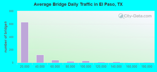
- 19,800,083Total average daily traffic
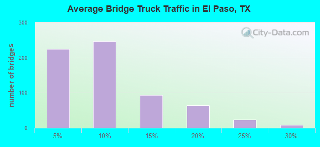
- 1,444,372Total average daily truck traffic
- National Bridge Inventory (NBI) Registered Bridges for El Paso
- No street view available for this location
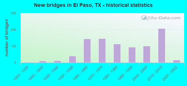
- New bridges - historical statistics
- 11910-1919
- 41920-1929
- 101930-1939
- 121940-1949
- 401950-1959
- 1441960-1969
- 1461970-1979
- 1131980-1989
- 941990-1999
- 1012000-2009
- 2072010-2019
- 162020-2022
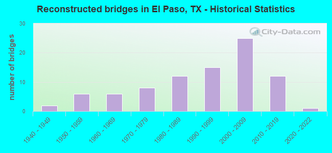
- Reconstructed bridges - Historical Statistics
- 21940-1949
- 61950-1959
- 61960-1969
- 81970-1979
- 121980-1989
- 151990-1999
- 252000-2009
- 122010-2019
- 12020-2022
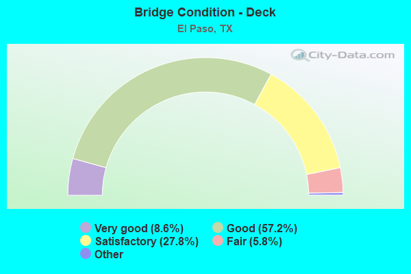
- Bridge Condition - Deck
- 8.6%Excellent
- 57.2%Very good
- 27.8%Good
- 5.8%Satisfactory
- 0.6%Fair
- 0.2%Poor
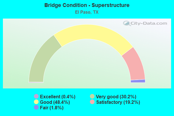
- Bridge Condition - Superstructure
- 0.4%Excellent
- 30.2%Very good
- 48.4%Good
- 19.2%Satisfactory
- 1.8%Fair
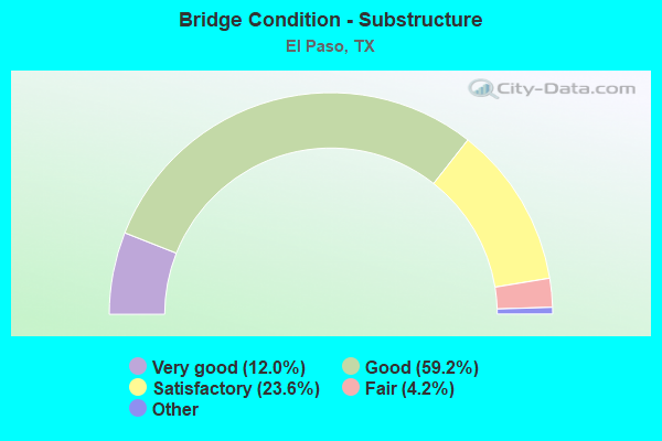
- Bridge Condition - Substructure
- 12.0%Excellent
- 59.2%Very good
- 23.6%Good
- 4.2%Satisfactory
- 1.0%Fair
- 0.6%Poor
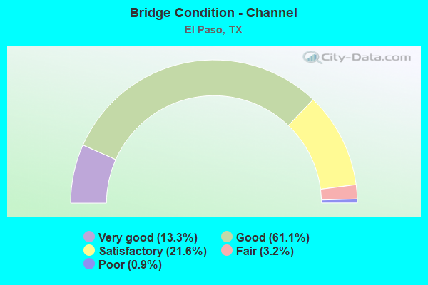
- Bridge Condition - Channel
- 13.3%Very good
- 61.1%Good
- 21.6%Satisfactory
- 3.2%Fair
- 0.9%Poor
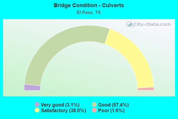
- Bridge Condition - Culverts
- 3.1%Very good
- 57.4%Good
- 38.0%Satisfactory
- 1.6%Poor
Find on map >> Show street view
Structure Number: 222400008614193, Location: 0.80 MI S OF US 59 (Lat: 27.516139, Lng: -99.448661), Route carried "on" structure: State highway 20, Year Built: 2017, Status: Open, Structure Length: 12.01m (39.40ft), Average Daily Traffic: 5,000 (year 2018), Truck Traffic: 5%, Average Future Daily Traffic: 1 (year 1900), Design Load: HL 93, Features Intersected: SP 400
Minimum Vertical Clearance: 30+ m (98+ ft), Kilometerpoint: 31.768, Lanes on structure: 4, Lanes under structure: 4, Owner: State Highway Agency, Approaching Roadway Width: 26.8m (87.9ft), Skew: 30 degrees, Material/Design: Prestressed concrete, Design/Construction: Stringer/Multi-beam, Number Of Spans In Main Unit: 3, Length of Maximum Span: 40.5m (132.9ft), Curb-To-Curb Width: 26.8m (87.9ft), Out-to-Out Width: 28.0m (91.9ft)
Condition: Deck: Good, Superstructure: Very good, Substructure: Good, Operating Rating: 54.4 metric tons, Method Used To Determine Operating Rating: Assigned ratings based on Load and Resistance Factor Design (LRFD) reported in metric tons, Inventory Rating: 32.7 metric tons, Method Used To Determine Inventory Rating: Assigned ratings based on Load and Resistance Factor Design (LRFD) reported in metric tons, Structural Evaluation: Better than present minimum criteria, Deck Geometry: Superior to present desirable criteria, Underclear: Better than present minimum criteria, Approach Roadway Alignment: Equal to present desirable criteria, Designated Inspection Frequency: Every 24 months, Inspection Date: December 2020, Deck Structure Type: Concrete Cast-file-Place
Find on map >> Show street view
Structure Number: 222400008614195, Location: 0.38 MI S OF SP 400 (Lat: 27.508600, Lng: -99.448289), Route carried "on" structure: ServiceState highway 20, Year Built: 2017, Status: Open, Structure Length: 29.41m (96.49ft), Average Daily Traffic: 4,000 (year 2019), Truck Traffic: 5%, Average Future Daily Traffic: 1 (year 1900), Design Load: HL 93, Features Intersected: KCS RR & DRAW
Minimum Vertical Clearance: 30+ m (98+ ft), Kilometerpoint: 32.428, Lanes on structure: 2, Owner: State Highway Agency, Approaching Roadway Width: 9.8m (32.2ft), Skew: 9 degrees, Material/Design: Prestressed concrete, Design/Construction: Stringer/Multi-beam, Number Of Spans In Main Unit: 7, Number Of Approach Spans: 2, Length of Maximum Span: 36.6m (120.1ft), Curb-To-Curb Width: 9.8m (32.2ft), Out-to-Out Width: 10.4m (34.1ft)
Condition: Deck: Good, Superstructure: Very good, Substructure: Very good, Channel: Very good, Operating Rating: 54.4 metric tons, Method Used To Determine Operating Rating: Assigned ratings based on Load and Resistance Factor Design (LRFD) reported in metric tons, Inventory Rating: 32.7 metric tons, Method Used To Determine Inventory Rating: Assigned ratings based on Load and Resistance Factor Design (LRFD) reported in metric tons, Structural Evaluation: Equal to present desirable criteria, Deck Geometry: Meets minimum limits, Underclear: Superior to present desirable criteria, Waterway Adequacy: Superior to present desirable criteria, Approach Roadway Alignment: Equal to present desirable criteria, Designated Inspection Frequency: Every 24 months, Inspection Date: December 2020, Deck Structure Type: Concrete Cast-file-Place
Find on map >> Show street view
Structure Number: 222400008614196, Location: 0.38 MI S OF SP 400 (Lat: 27.510150, Lng: -99.448719), Route carried "on" structure: ServiceState highway 20, Year Built: 2019, Status: Open, Structure Length: 25.18m (82.61ft), Average Daily Traffic: 4,000 (year 2019), Truck Traffic: 5%, Average Future Daily Traffic: 5,000 (year 2039), Design Load: HL 93, Features Intersected: KCS RR & DRAW
Minimum Vertical Clearance: 30+ m (98+ ft), Kilometerpoint: 32.412, Lanes on structure: 2, Owner: State Highway Agency, Approaching Roadway Width: 9.8m (32.2ft), Skew: 9 degrees, Material/Design: Prestressed concrete, Design/Construction: Stringer/Multi-beam, Number Of Spans In Main Unit: 7, Length of Maximum Span: 36.9m (121.1ft), Curb-To-Curb Width: 9.8m (32.2ft), Out-to-Out Width: 11.1m (36.4ft)
Condition: Deck: Good, Superstructure: Very good, Substructure: Very good, Channel: Very good, Operating Rating: 54.4 metric tons, Method Used To Determine Operating Rating: Assigned ratings based on Load and Resistance Factor Design (LRFD) reported in metric tons, Inventory Rating: 32.7 metric tons, Method Used To Determine Inventory Rating: Assigned ratings based on Load and Resistance Factor Design (LRFD) reported in metric tons, Structural Evaluation: Equal to present desirable criteria, Deck Geometry: Meets minimum limits, Underclear: Superior to present desirable criteria, Waterway Adequacy: Superior to present desirable criteria, Approach Roadway Alignment: Equal to present desirable criteria, Designated Inspection Frequency: Every 24 months, Inspection Date: December 2020, Deck Structure Type: Concrete Cast-file-Place
Find on map >> Show street view
Structure Number: 222400008614197, Location: 2.3 MI W OF IH 35 (Lat: 27.613161, Lng: -99.465769), Route carried "on" structure: State highway 20, Year Built: 2017, Status: Open, Structure Length: 8.78m (28.81ft), Average Daily Traffic: 15,500 (year 2013), Truck Traffic: 5%, Average Future Daily Traffic: 21,300 (year 2033), Design Load: HL 93, Features Intersected: INTERNATIONAL BLVD
Minimum Vertical Clearance: 30+ m (98+ ft), Kilometerpoint: 0.000, Lanes on structure: 2, Lanes under structure: 8, Owner: State Highway Agency, Approaching Roadway Width: 17.1m (56.1ft), Skew: 10 degrees, Material/Design: Prestressed concrete, Design/Construction: Stringer/Multi-beam, Number Of Spans In Main Unit: 3, Length of Maximum Span: 30.5m (100.1ft), Curb-To-Curb Width: 17.1m (56.1ft), Out-to-Out Width: 17.7m (58.1ft)
Condition: Deck: Good, Superstructure: Good, Substructure: Good, Operating Rating: 54.4 metric tons, Method Used To Determine Operating Rating: Assigned ratings based on Load and Resistance Factor Design (LRFD) reported in metric tons, Inventory Rating: 32.7 metric tons, Method Used To Determine Inventory Rating: Assigned ratings based on Load and Resistance Factor Design (LRFD) reported in metric tons, Structural Evaluation: Better than present minimum criteria, Deck Geometry: Superior to present desirable criteria, Underclear: Meets minimum limits, Approach Roadway Alignment: Equal to present desirable criteria, Designated Inspection Frequency: Every 24 months, Inspection Date: December 2020, Deck Structure Type: Concrete Cast-file-Place
Find on map >> Show street view
Structure Number: 222400008614198, Location: 2.3 MI W OF IH 35 (Lat: 27.612869, Lng: -99.466639), Route carried "on" structure: State highway 20, Year Built: 2017, Status: Open, Structure Length: 8.78m (28.81ft), Average Daily Traffic: 15,500 (year 2013), Truck Traffic: 5%, Average Future Daily Traffic: 21,300 (year 2033), Design Load: HL 93, Features Intersected: INTERNATIONAL BLVD
Minimum Vertical Clearance: 30+ m (98+ ft), Kilometerpoint: 0.000, Lanes on structure: 2, Lanes under structure: 6, Owner: State Highway Agency, Approaching Roadway Width: 17.1m (56.1ft), Skew: 10 degrees, Material/Design: Prestressed concrete, Design/Construction: Stringer/Multi-beam, Number Of Spans In Main Unit: 3, Length of Maximum Span: 30.5m (100.1ft), Curb-To-Curb Width: 17.1m (56.1ft), Out-to-Out Width: 17.3m (56.8ft)
Condition: Deck: Good, Superstructure: Good, Substructure: Good, Operating Rating: 54.4 metric tons, Method Used To Determine Operating Rating: Assigned ratings based on Load and Resistance Factor Design (LRFD) reported in metric tons, Inventory Rating: 32.7 metric tons, Method Used To Determine Inventory Rating: Assigned ratings based on Load and Resistance Factor Design (LRFD) reported in metric tons, Structural Evaluation: Better than present minimum criteria, Deck Geometry: Superior to present desirable criteria, Underclear: High priority of corrective action, Approach Roadway Alignment: Equal to present desirable criteria, Designated Inspection Frequency: Every 24 months, Inspection Date: December 2020, Deck Structure Type: Concrete Cast-file-Place
Find on map >> Show street view
Structure Number: 222400B00342001, Location: 0.22 MI E OF MCPHERSON (Lat: 27.563561, Lng: -99.469400), Route carried "on" structure: City street , Year Built: 2005, Status: Open, Structure Length: 2.87m (9.42ft), Average Daily Traffic: 2,000 (year 2018), Truck Traffic: 2%, Average Future Daily Traffic: 1 (year 1900), Features Intersected: ZACATE CREEK, Facility Carried by Structure: FENWICK DR
Minimum Vertical Clearance: 30+ m (98+ ft), Kilometerpoint: 1.609, Lanes on structure: 4, Owner: City or Municipal Highway Agency, Approaching Roadway Width: 14.6m (47.9ft), Material/Design: Steel, Design/Construction: Culvert, Number Of Spans In Main Unit: 9, Length of Maximum Span: 2.4m (7.9ft), Curb or Sidewalk Widths: Left: 2.0m (6.6ft), Right: 2.0m (6.6ft), Out-to-Out Width: 44.3m (145.3ft)
Condition: Channel: Satisfactory, Culverts: Satisfactory, Operating Rating: 32.7 metric tons, Method Used To Determine Operating Rating: No rating analysis performed, Inventory Rating: 24.5 metric tons, Method Used To Determine Inventory Rating: No rating analysis performed, Structural Evaluation: Equal to present minimum criteria, Waterway Adequacy: Equal to present minimum criteria, Approach Roadway Alignment: Equal to present desirable criteria, Designated Inspection Frequency: Every 24 months, Inspection Date: October 2020
Find on map >> Show street view
Structure Number: 222400B01305001, Location: 0.32 MI S OF E DEL MAR (Lat: 27.575519, Lng: -99.457519), Route carried "on" structure: City street , Year Built: 2016, Status: Open, Structure Length: 2.62m (8.60ft), Average Daily Traffic: 1,000 (year 2018), Truck Traffic: 5%, Average Future Daily Traffic: 3,000 (year 2038), Design Load: HS 20, Features Intersected: ZACATE CREEK, Facility Carried by Structure: BARTLETT AVE
Minimum Vertical Clearance: 30+ m (98+ ft), Kilometerpoint: 2.301, Lanes on structure: 4, Owner: City or Municipal Highway Agency, Approaching Roadway Width: 14.3m (46.9ft), Material/Design: Concrete, Design/Construction: Culvert, Number Of Spans In Main Unit: 8, Length of Maximum Span: 3.0m (9.8ft), Curb or Sidewalk Widths: Left: 3.0m (9.8ft), Right: 3.0m (9.8ft), Curb-To-Curb Width: 14.3m (46.9ft), Out-to-Out Width: 21.3m (69.9ft)
Condition: Channel: Good, Culverts: Good, Operating Rating: 44.4 metric tons, Method Used To Determine Operating Rating: Assigned rating based on Load Factor Design (LFD) reported in metric tons, Inventory Rating: 32.7 metric tons, Method Used To Determine Inventory Rating: Assigned rating based on Load Factor Design (LFD) reported in metric tons, Structural Evaluation: Better than present minimum criteria, Deck Geometry: High priority of replacement, Waterway Adequacy: Equal to present minimum criteria, Approach Roadway Alignment: Equal to present desirable criteria, Designated Inspection Frequency: Every 24 months, Inspection Date: October 2020, Deck Structure Type: Concrete Cast-file-Place, Wearing Surface/Protective System: Wearing Surface: Monolithic Concrete
Find on map >> Show street view
Structure Number: 240720000101001, Location: 1.73 MI S OF NM ST LINE (Lat: 31.975761, Lng: -106.604586), Route carried "on" structure: State highway 20, Year Built: 1934, Year Reconstructed: 1954, Status: Open, Structure Length: 0.82m (2.69ft), Average Daily Traffic: 8,668 (year 2020), Truck Traffic: 11%, Average Future Daily Traffic: 9,840 (year 2033), Features Intersected: DRAIN
Minimum Vertical Clearance: 30+ m (98+ ft), Kilometerpoint: 2.776, Lanes on structure: 4, Owner: State Highway Agency, Approaching Roadway Width: 18.6m (61.0ft), Material/Design: Concrete, Design/Construction: Culvert, Number Of Spans In Main Unit: 4, Length of Maximum Span: 1.8m (5.9ft), Curb-To-Curb Width: 18.6m (61.0ft), Out-to-Out Width: 20.7m (67.9ft)
Condition: Channel: Good, Culverts: Satisfactory, Operating Rating: 32.7 metric tons, Method Used To Determine Operating Rating: Field evaluation and documented engineering judgment, Inventory Rating: 24.5 metric tons, Method Used To Determine Inventory Rating: Field evaluation and documented engineering judgment, Structural Evaluation: Equal to present minimum criteria, Deck Geometry: Equal to present minimum criteria, Waterway Adequacy: Equal to present minimum criteria, Approach Roadway Alignment: Equal to present desirable criteria, Designated Inspection Frequency: Every 24 months, Inspection Date: April 2021, Deck Structure Type: Concrete Cast-file-Place, Wearing Surface/Protective System: Wearing Surface: Bituminous
Find on map >> Show street view
Structure Number: 240720000101025, Location: 1.8 MI S OF FM 259 (Lat: 31.890306, Lng: -106.597556), Route carried "on" structure: State highway 20, Year Built: 1943, Year Reconstructed: 1954, Status: Open, Structure Length: 4.72m (15.49ft), Average Daily Traffic: 13,134 (year 2017), Truck Traffic: 7%, Average Future Daily Traffic: 23,180 (year 2033), Design Load: H 20, Features Intersected: DRAIN
Minimum Vertical Clearance: 30+ m (98+ ft), Kilometerpoint: 12.323, Lanes on structure: 4, Owner: State Highway Agency, Approaching Roadway Width: 20.1m (65.9ft), Material/Design: Concrete, Design/Construction: Culvert, Number Of Spans In Main Unit: 20, Length of Maximum Span: 2.1m (6.9ft), Curb-To-Curb Width: 20.0m (65.6ft), Out-to-Out Width: 20.7m (67.9ft)
Condition: Channel: Good, Culverts: Satisfactory, Operating Rating: 39.9 metric tons, Method Used To Determine Operating Rating: Load Factor (LF), Inventory Rating: 23.6 metric tons, Method Used To Determine Inventory Rating: Load Factor (LF), Structural Evaluation: Somewhat better than minimum adequacy, Deck Geometry: Better than present minimum criteria, Waterway Adequacy: Equal to present minimum criteria, Approach Roadway Alignment: Equal to present desirable criteria, Designated Inspection Frequency: Every 24 months, Inspection Date: April 2021, Deck Structure Type: Concrete Cast-file-Place, Wearing Surface/Protective System: Wearing Surface: Bituminous
Find on map >> Show street view
Structure Number: 240720000101068, Location: 0.7 MI W OF IH 10 (Lat: 31.879442, Lng: -106.593789), Route carried "on" structure: State highway 178, Year Built: 2000, Status: Open, Structure Length: 14.02m (46.00ft), Average Daily Traffic: 3,200 (year 2015), Truck Traffic: 12%, Average Future Daily Traffic: 13,000 (year 2035), Design Load: HS 20, Features Intersected: SH 20 & BNSF RR
Minimum Vertical Clearance: 30+ m (98+ ft), Kilometerpoint: 3.447, Lanes on structure: 6, Lanes under structure: 8, Owner: State Highway Agency, Approaching Roadway Width: 34.7m (113.8ft), Skew: 30 degrees, Material/Design: Prestressed concrete, Design/Construction: Stringer/Multi-beam, Number Of Spans In Main Unit: 4, Length of Maximum Span: 36.6m (120.1ft), Curb-To-Curb Width: 34.7m (113.8ft), Out-to-Out Width: 36.0m (118.1ft)
Condition: Deck: Good, Superstructure: Very good, Substructure: Very good, Operating Rating: 54.4 metric tons, Method Used To Determine Operating Rating: Assigned rating based on Load Factor Design (LFD) reported in metric tons, Inventory Rating: 32.7 metric tons, Method Used To Determine Inventory Rating: Assigned rating based on Load Factor Design (LFD) reported in metric tons, Structural Evaluation: Equal to present desirable criteria, Deck Geometry: Superior to present desirable criteria, Underclear: Equal to present minimum criteria, Approach Roadway Alignment: Equal to present desirable criteria, Designated Inspection Frequency: Every 24 months, Inspection Date: April 2021, Deck Structure Type: Concrete Cast-file-Place, Wearing Surface/Protective System: Deck Protection: Epoxy Coated Reinforcing
Find on map >> Show street view
Structure Number: 24072000010201, Location: 4.0 MI E OF IH 10 (Lat: 31.815028, Lng: -106.513564), Route carried "on" structure: State highway 20, Year Built: 1925, Year Reconstructed: 1961, Status: Open, Structure Length: 0.70m (2.30ft), Average Daily Traffic: 44,973 (year 2017), Truck Traffic: 5%, Average Future Daily Traffic: 58,230 (year 2031), Design Load: H 15, Features Intersected: DRAIN
Minimum Vertical Clearance: 30+ m (98+ ft), Kilometerpoint: 25.185, Lanes on structure: 6, Base Highway Network: Yes, Owner: State Highway Agency, Approaching Roadway Width: 29.3m (96.1ft), Skew: 29 degrees, Material/Design: Concrete, Design/Construction: Culvert, Number Of Spans In Main Unit: 5, Length of Maximum Span: 1.2m (3.9ft)
Condition: Channel: Good, Culverts: Satisfactory, Operating Rating: 39.9 metric tons, Method Used To Determine Operating Rating: Load Factor (LF), Inventory Rating: 23.6 metric tons, Method Used To Determine Inventory Rating: Load Factor (LF), Structural Evaluation: Somewhat better than minimum adequacy, Waterway Adequacy: Equal to present minimum criteria, Approach Roadway Alignment: Equal to present desirable criteria, Designated Inspection Frequency: Every 24 months, Inspection Date: August 2021
Find on map >> Show street view
Structure Number: 240720000102011, Location: 5.5 MI E OF IH 10 (Lat: 31.793581, Lng: -106.509372), Route carried "on" structure: State highway 20, Year Built: 1925, Year Reconstructed: 1961, Status: Open, Structure Length: 0.70m (2.30ft), Average Daily Traffic: 27,254 (year 2017), Truck Traffic: 6%, Average Future Daily Traffic: 47,270 (year 2033), Design Load: H 15, Features Intersected: DRAIN
Minimum Vertical Clearance: 30+ m (98+ ft), Kilometerpoint: 27.716, Lanes on structure: 6, Base Highway Network: Yes, Owner: State Highway Agency, Approaching Roadway Width: 29.3m (96.1ft), Skew: 20 degrees, Material/Design: Concrete, Design/Construction: Culvert, Number Of Spans In Main Unit: 5, Length of Maximum Span: 1.2m (3.9ft)
Condition: Channel: Poor, Culverts: Satisfactory, Operating Rating: 39.9 metric tons, Method Used To Determine Operating Rating: Load Factor (LF), Inventory Rating: 23.6 metric tons, Method Used To Determine Inventory Rating: Load Factor (LF), Structural Evaluation: Somewhat better than minimum adequacy, Waterway Adequacy: Equal to present minimum criteria, Approach Roadway Alignment: Equal to present desirable criteria, Designated Inspection Frequency: Every 24 months, Inspection Date: August 2021
Find on map >> Show street view
Structure Number: 240720000102228, Location: 0.75 MI SE OF US 85 (Lat: 31.795622, Lng: -106.531456), Route carried "on" structure: State highway 375, Year Built: 2018, Status: Open, Structure Length: 4.45m (14.60ft), Average Daily Traffic: 10,100 (year 2015), Truck Traffic: 10%, Average Future Daily Traffic: 23,900 (year 2035), Design Load: HL 93, Features Intersected: DONIPHAN DRIVE WB
Minimum Vertical Clearance: 30+ m (98+ ft), Kilometerpoint: 0.000, Lanes on structure: 5, Lanes under structure: 1, Base Highway Network: Yes, Toll: On toll road, Owner: Local Toll Authority, Approaching Roadway Width: 31.1m (102.0ft), Skew: 36 degrees, Material/Design: Prestressed concrete, Design/Construction: Stringer/Multi-beam, Number Of Spans In Main Unit: 1, Length of Maximum Span: 44.5m (146.0ft), Curb-To-Curb Width: 31.2m (102.4ft), Out-to-Out Width: 32.9m (107.9ft)
Condition: Deck: Good, Superstructure: Very good, Substructure: Good, Operating Rating: 54.4 metric tons, Method Used To Determine Operating Rating: Assigned ratings based on Load and Resistance Factor Design (LRFD) reported in metric tons, Inventory Rating: 32.7 metric tons, Method Used To Determine Inventory Rating: Assigned ratings based on Load and Resistance Factor Design (LRFD) reported in metric tons, Structural Evaluation: Better than present minimum criteria, Deck Geometry: Superior to present desirable criteria, Underclear: Better than present minimum criteria, Approach Roadway Alignment: Equal to present desirable criteria, Designated Inspection Frequency: Every 24 months, Inspection Date: August 2021, Deck Structure Type: Concrete Cast-file-Place
Find on map >> Show street view
Structure Number: 240720000102229, Location: 0.20 MI SE OF US 85 (Lat: 31.801650, Lng: -106.535700), Route carried "on" structure: State highway , Year Built: 2018, Status: Open, Structure Length: 12.37m (40.58ft), Average Daily Traffic: 5,000 (year 2015), Truck Traffic: 5%, Average Future Daily Traffic: 10,000 (year 2035), Design Load: HL 93, Features Intersected: WATER # 6, Facility Carried by Structure: DONIPHAN DRIVE WB
Minimum Vertical Clearance: 30+ m (98+ ft), Kilometerpoint: 0.000, Lanes on structure: 2, Base Highway Network: Yes, Toll: On toll road, Owner: Local Toll Authority, Approaching Roadway Width: 10.7m (35.1ft), Skew: 21 degrees, Material/Design: Prestressed concrete, Design/Construction: Stringer/Multi-beam, Number Of Spans In Main Unit: 3, Length of Maximum Span: 41.1m (134.8ft), Curb-To-Curb Width: 10.9m (35.8ft), Out-to-Out Width: 17.1m (56.1ft)
Condition: Deck: Good, Superstructure: Very good, Substructure: Very good, Channel: Very good, Operating Rating: 54.4 metric tons, Method Used To Determine Operating Rating: Assigned ratings based on Load and Resistance Factor Design (LRFD) reported in metric tons, Inventory Rating: 32.7 metric tons, Method Used To Determine Inventory Rating: Assigned ratings based on Load and Resistance Factor Design (LRFD) reported in metric tons, Structural Evaluation: Equal to present desirable criteria, Deck Geometry: Meets minimum limits, Waterway Adequacy: Superior to present desirable criteria, Approach Roadway Alignment: Equal to present desirable criteria, Designated Inspection Frequency: Every 24 months, Inspection Date: August 2021, Deck Structure Type: Concrete Cast-file-Place
Find on map >> Show street view
Structure Number: 240720000103041, Location: 1.0 MI NW OF IH 10 (Lat: 31.774747, Lng: -106.501272), Route carried "on" structure: State highway 20, Year Built: 1921, Year Reconstructed: 1956, Status: Open, Structure Length: 0.85m (2.79ft), Average Daily Traffic: 27,254 (year 2017), Truck Traffic: 6%, Average Future Daily Traffic: 47,270 (year 2033), Features Intersected: DRAIN
Minimum Vertical Clearance: 30+ m (98+ ft), Kilometerpoint: 0.298, Lanes on structure: 5, Base Highway Network: Yes, Owner: State Highway Agency, Approaching Roadway Width: 17.7m (58.1ft), Material/Design: Concrete, Design/Construction: Slab, Number Of Spans In Main Unit: 2, Length of Maximum Span: 4.3m (14.1ft), Curb or Sidewalk Widths: Left: 1.2m (3.9ft), Right: 1.2m (3.9ft), Curb-To-Curb Width: 17.7m (58.1ft), Out-to-Out Width: 20.7m (67.9ft)
Condition: Deck: Satisfactory, Superstructure: Satisfactory, Substructure: Satisfactory, Channel: Satisfactory, Operating Rating: 32.7 metric tons, Method Used To Determine Operating Rating: Field evaluation and documented engineering judgment, Inventory Rating: 24.5 metric tons, Method Used To Determine Inventory Rating: Field evaluation and documented engineering judgment, Structural Evaluation: Equal to present minimum criteria, Deck Geometry: High priority of replacement, Waterway Adequacy: Equal to present minimum criteria, Approach Roadway Alignment: Equal to present desirable criteria, Length Of Structure Improvement: 0.85m (2.79ft), Designated Inspection Frequency: Every 24 months, Inspection Date: August 2021, Bridge Improvement Cost: $3,000, Roadway Improvement Cost: $1,000, Total Project Cost: $4,000, Deck Structure Type: Concrete Cast-file-Place, Wearing Surface/Protective System: Wearing Surface: Bituminous
Find on map >> Show street view
Structure Number: 240720000103055, Location: 0.2 MI S OF IH 10 (Lat: 31.760558, Lng: -106.488703), Route carried "on" structure: State highway 20, Year Built: 1960, Status: Open, Structure Length: 1.45m (4.76ft), Average Daily Traffic: 27,254 (year 2017), Truck Traffic: 6%, Average Future Daily Traffic: 47,270 (year 2033), Design Load: H 20, Features Intersected: UP RR
Minimum Vertical Clearance: 30+ m (98+ ft), Kilometerpoint: 2.258, Lanes on structure: 4, Maintenance Responsibility: City or Municipal Highway Agency, Approaching Roadway Width: 15.2m (49.9ft), Material/Design: Steel, Design/Construction: Stringer/Multi-beam, Number Of Spans In Main Unit: 1, Length of Maximum Span: 14.5m (47.6ft), Curb or Sidewalk Widths: Left: 3.0m (9.8ft), Right: 3.0m (9.8ft), Curb-To-Curb Width: 15.2m (49.9ft), Out-to-Out Width: 21.9m (71.9ft)
Condition: Deck: Good, Superstructure: Good, Substructure: Good, Operating Rating: 46.3 metric tons, Method Used To Determine Operating Rating: Load Factor (LF), Inventory Rating: 28.1 metric tons, Method Used To Determine Inventory Rating: Load Factor (LF), Structural Evaluation: Better than present minimum criteria, Deck Geometry: High priority of corrective action, Underclear: Meets minimum limits, Approach Roadway Alignment: Equal to present desirable criteria, Length Of Structure Improvement: 1.52m (4.99ft), Designated Inspection Frequency: Every 24 months, Inspection Date: May 2020, Bridge Improvement Cost: $5,000, Roadway Improvement Cost: $1,000, Total Project Cost: $6,000, Deck Structure Type: Concrete Cast-file-Place
Find on map >> Show street view
Structure Number: 240720000104046, Location: 1.9 MI E OF NM HWY 273 (Lat: 31.790967, Lng: -106.527603), Route carried "on" structure: US 85, Year Built: 1957, Status: Posted for load, Structure Length: 18.17m (59.61ft), Average Daily Traffic: 22,062 (year 2020), Truck Traffic: 7%, Average Future Daily Traffic: 13,510 (year 2033), Design Load: HS 20, Features Intersected: RIO GRANDE RIVER
Minimum Vertical Clearance: 30+ m (98+ ft), Kilometerpoint: 3.003, Lanes on structure: 2, Base Highway Network: Yes, Owner: State Highway Agency, Approaching Roadway Width: 7.3m (24.0ft), Material/Design: Concrete continuous, Design/Construction: Tee Beam, Number Of Spans In Main Unit: 38, Length of Maximum Span: 4.3m (14.1ft), Curb or Sidewalk Widths: Left: 0.0m, Right: 0.8m (2.6ft), Curb-To-Curb Width: 7.1m (23.3ft), Out-to-Out Width: 9.2m (30.2ft)
Condition: Deck: Fair, Superstructure: Fair, Substructure: Poor, Channel: Good, Operating Rating: 34.5 metric tons, Method Used To Determine Operating Rating: Load Factor (LF), Inventory Rating: 20.9 metric tons, Method Used To Determine Inventory Rating: Load Factor (LF), Structural Evaluation: Meets minimum limits, Deck Geometry: High priority of replacement, Waterway Adequacy: Equal to present minimum criteria, Approach Roadway Alignment: Equal to present desirable criteria, Length Of Structure Improvement: 18.17m (59.61ft), Designated Inspection Frequency: Every 24 months, Inspection Date: August 2021, Bridge Improvement Cost: $27,000, Roadway Improvement Cost: $7,000, Total Project Cost: $34,000, Deck Structure Type: Concrete Cast-file-Place
Find on map >> Show street view
Structure Number: 240720000104047, Location: 2.1 MI E OF NM HWY 273 (Lat: 31.788414, Lng: -106.525794), Route carried "on" structure: US 85, Year Built: 1957, Status: Open, Structure Length: 1.59m (5.22ft), Average Daily Traffic: 22,062 (year 2020), Truck Traffic: 7%, Average Future Daily Traffic: 27,030 (year 2033), Design Load: HS 20, Features Intersected: CEMENT PLANT ARROYO
Minimum Vertical Clearance: 30+ m (98+ ft), Kilometerpoint: 3.417, Lanes on structure: 6, Base Highway Network: Yes, Owner: State Highway Agency, Approaching Roadway Width: 27.4m (89.9ft), Skew: 20 degrees, Material/Design: Concrete, Design/Construction: Culvert, Number Of Spans In Main Unit: 6, Length of Maximum Span: 2.4m (7.9ft), Curb or Sidewalk Widths: Left: 1.3m (4.3ft), Right: 0.0m
Condition: Channel: Satisfactory, Culverts: Satisfactory, Operating Rating: 39.9 metric tons, Method Used To Determine Operating Rating: Load Factor (LF), Inventory Rating: 23.6 metric tons, Method Used To Determine Inventory Rating: Load Factor (LF), Structural Evaluation: Somewhat better than minimum adequacy, Waterway Adequacy: Equal to present minimum criteria, Approach Roadway Alignment: Equal to present desirable criteria, Designated Inspection Frequency: Every 24 months, Inspection Date: August 2021
Find on map >> Show street view
Structure Number: 240720000104057, Location: 1.6 MI W OF IH 110 (Lat: 31.761783, Lng: -106.473731), Route carried "on" structure: State highway 171, Year Built: 1971, Status: Open, Structure Length: 29.41m (96.49ft), Average Daily Traffic: 5,680 (year 2009), Average Future Daily Traffic: 10,000 (year 2029), Design Load: HS 20, Features Intersected: US 62 & UP RR YARD, Facility Carried by Structure: COTTON ST SB
Minimum Vertical Clearance: 30+ m (98+ ft), Kilometerpoint: 0.164, Lanes on structure: 2, Lanes under structure: 7, Owner: State Highway Agency, Maintenance Responsibility: City or Municipal Highway Agency, Approaching Roadway Width: 8.5m (27.9ft), Skew: 9 degrees, Material/Design: Prestressed concrete, Design/Construction: Stringer/Multi-beam, Number Of Spans In Main Unit: 2, Number Of Approach Spans: 16, Length of Maximum Span: 26.8m (87.9ft), Curb-To-Curb Width: 8.5m (27.9ft), Out-to-Out Width: 9.6m (31.5ft)
Condition: Deck: Good, Superstructure: Satisfactory, Substructure: Satisfactory, Operating Rating: 54.4 metric tons, Method Used To Determine Operating Rating: Assigned rating based on Load Factor Design (LFD) reported in metric tons, Inventory Rating: 32.7 metric tons, Method Used To Determine Inventory Rating: Assigned rating based on Load Factor Design (LFD) reported in metric tons, Structural Evaluation: Equal to present minimum criteria, Deck Geometry: High priority of corrective action, Underclear: High priority of corrective action, Approach Roadway Alignment: Equal to present desirable criteria, Length Of Structure Improvement: 29.41m (96.49ft), Designated Inspection Frequency: Every 24 months, Inspection Date: May 2021, Bridge Improvement Cost: $54,000, Roadway Improvement Cost: $14,000, Total Project Cost: $68,000, Deck Structure Type: Concrete Cast-file-Place
Find on map >> Show street view
Structure Number: 240720000104063, Location: 3.3 MI W OF IH 110 (Lat: 31.757781, Lng: -106.500817), Route carried "on" structure: US 85, Year Built: 1953, Year Reconstructed: 1976, Status: Open, Structure Length: 42.31m (138.81ft), Average Daily Traffic: 13,672 (year 2020), Truck Traffic: 8%, Average Future Daily Traffic: 20,740 (year 2033), Design Load: HS 20, Features Intersected: BNSF RR YARD
Minimum Vertical Clearance: 30+ m (98+ ft), Kilometerpoint: 7.854, Lanes on structure: 4, Owner: State Highway Agency, Approaching Roadway Width: 15.9m (52.2ft), Skew: 30 degrees, Material/Design: Steel continuous, Design/Construction: Stringer/Multi-beam, Number Of Spans In Main Unit: 16, Number Of Approach Spans: 18, Length of Maximum Span: 15.5m (50.9ft), Curb or Sidewalk Widths: Left: 1.1m (3.6ft), Right: 0.0m, Curb-To-Curb Width: 16.0m (52.5ft), Out-to-Out Width: 19.0m (62.3ft)
Condition: Deck: Good, Superstructure: Good, Substructure: Fair, Operating Rating: 65.3 metric tons, Method Used To Determine Operating Rating: Load Factor (LF), Inventory Rating: 39.0 metric tons, Method Used To Determine Inventory Rating: Load Factor (LF), Structural Evaluation: Somewhat better than minimum adequacy, Deck Geometry: Meets minimum limits, Underclear: Meets minimum limits, Approach Roadway Alignment: Equal to present desirable criteria, Designated Inspection Frequency: Every 24 months, Inspection Date: May 2021, Deck Structure Type: Concrete Cast-file-Place, Wearing Surface/Protective System: Wearing Surface: Bituminous
Find on map >> Show street view
Structure Number: 240720000104066, Location: 1.2 MI W OF IH 10 (Lat: 31.762325, Lng: -106.468672), Route carried "on" structure: US 62, Year Built: 1988, Status: Open, Structure Length: 34.69m (113.81ft), Average Daily Traffic: 14,010 (year 2013), Truck Traffic: 11%, Average Future Daily Traffic: 19,620 (year 2033), Design Load: HS 20, Features Intersected: UP RR CANAL AND STREETS
Minimum Vertical Clearance: 30+ m (98+ ft), Kilometerpoint: 11.264, Lanes on structure: 3, Lanes under structure: 4, Base Highway Network: Yes, Owner: State Highway Agency, Approaching Roadway Width: 11.3m (37.1ft), Skew: 9 degrees, Material/Design: Prestressed concrete, Design/Construction: Box Beam or Girders - Multiple, Number Of Spans In Main Unit: 3, Number Of Approach Spans: 13, Length of Maximum Span: 24.4m (80.1ft), Curb or Sidewalk Widths: Left: 0.0m, Right: 1.2m (3.9ft), Curb-To-Curb Width: 11.3m (37.1ft), Out-to-Out Width: 13.6m (44.6ft)
Condition: Deck: Satisfactory, Superstructure: Good, Substructure: Good, Channel: Good, Operating Rating: 54.4 metric tons, Method Used To Determine Operating Rating: Assigned rating based on Load Factor Design (LFD) reported in metric tons, Inventory Rating: 32.7 metric tons, Method Used To Determine Inventory Rating: Assigned rating based on Load Factor Design (LFD) reported in metric tons, Structural Evaluation: Better than present minimum criteria, Deck Geometry: High priority of replacement, Underclear: High priority of corrective action, Waterway Adequacy: Superior to present desirable criteria, Approach Roadway Alignment: Equal to present desirable criteria, Designated Inspection Frequency: Every 24 months, Inspection Date: May 2021, Deck Structure Type: Concrete Precast Panels
Find on map >> Show street view
Structure Number: 240720000104068, Location: 0.25 MI S OF US 85 (Lat: 31.762367, Lng: -106.508464), Route carried "on" structure: ServiceUS 85, Year Built: 1940, Status: Open, Structure Length: 1.10m (3.61ft), Average Daily Traffic: 13,672 (year 2020), Truck Traffic: 6%, Average Future Daily Traffic: 15,490 (year 2030), Features Intersected: HART MILL ARROYO
Minimum Vertical Clearance: 30+ m (98+ ft), Kilometerpoint: 6.970, Lanes on structure: 2, Owner: State Highway Agency, Approaching Roadway Width: 5.5m (18.0ft), Skew: 4 degrees, Material/Design: Concrete, Design/Construction: Culvert, Number Of Spans In Main Unit: 4, Length of Maximum Span: 1.8m (5.9ft)
Condition: Channel: Good, Culverts: Satisfactory, Operating Rating: 32.7 metric tons, Method Used To Determine Operating Rating: Field evaluation and documented engineering judgment, Inventory Rating: 24.5 metric tons, Method Used To Determine Inventory Rating: Field evaluation and documented engineering judgment, Structural Evaluation: Equal to present minimum criteria, Waterway Adequacy: Equal to present minimum criteria, Approach Roadway Alignment: Equal to present desirable criteria, Designated Inspection Frequency: Every 24 months, Inspection Date: March 2020
Find on map >> Show street view
Structure Number: 240720000104069, Location: 1.6 MI S OF IH 10 (Lat: 31.759144, Lng: -106.473592), Route carried "on" structure: State highway 171, Year Built: 1971, Status: Open, Structure Length: 29.41m (96.49ft), Average Daily Traffic: 5,680 (year 2009), Average Future Daily Traffic: 10,000 (year 2029), Design Load: HS 20, Features Intersected: US62 UPRR YARD OVERLAND, Facility Carried by Structure: COTTON ST NB
Minimum Vertical Clearance: 30+ m (98+ ft), Kilometerpoint: 0.164, Lanes on structure: 2, Lanes under structure: 7, Owner: State Highway Agency, Maintenance Responsibility: City or Municipal Highway Agency, Approaching Roadway Width: 8.5m (27.9ft), Skew: 9 degrees, Material/Design: Prestressed concrete, Design/Construction: Stringer/Multi-beam, Number Of Spans In Main Unit: 2, Number Of Approach Spans: 16, Length of Maximum Span: 26.8m (87.9ft), Curb or Sidewalk Widths: Left: 0.0m, Right: 1.3m (4.3ft), Curb-To-Curb Width: 8.5m (27.9ft), Out-to-Out Width: 10.7m (35.1ft)
Condition: Deck: Good, Superstructure: Satisfactory, Substructure: Satisfactory, Operating Rating: 54.4 metric tons, Method Used To Determine Operating Rating: Assigned rating based on Load Factor Design (LFD) reported in metric tons, Inventory Rating: 32.7 metric tons, Method Used To Determine Inventory Rating: Assigned ratings based on Load and Resistance Factor Design (LRFD) reported in metric tons, Structural Evaluation: Equal to present minimum criteria, Deck Geometry: High priority of corrective action, Underclear: High priority of corrective action, Approach Roadway Alignment: Equal to present desirable criteria, Length Of Structure Improvement: 29.41m (96.49ft), Designated Inspection Frequency: Every 24 months, Inspection Date: May 2021, Bridge Improvement Cost: $54,000, Roadway Improvement Cost: $14,000, Total Project Cost: $68,000, Deck Structure Type: Concrete Cast-file-Place
Find on map >> Show street view
Structure Number: 240720000104226, Location: 1.20 MI W OF IH 10 (Lat: 31.764508, Lng: -106.465889), Route carried "on" structure: US 62, Year Built: 1988, Status: Open, Structure Length: 34.69m (113.81ft), Average Daily Traffic: 17,000 (year 2009), Truck Traffic: 7%, Average Future Daily Traffic: 23,800 (year 2029), Design Load: HS 20, Features Intersected: UPRR CANAL AND STREETS
Minimum Vertical Clearance: 30+ m (98+ ft), Kilometerpoint: 11.264, Lanes on structure: 3, Lanes under structure: 4, Base Highway Network: Yes, Owner: State Highway Agency, Approaching Roadway Width: 11.3m (37.1ft), Skew: 9 degrees, Material/Design: Prestressed concrete, Design/Construction: Box Beam or Girders - Multiple, Number Of Spans In Main Unit: 3, Number Of Approach Spans: 13, Length of Maximum Span: 24.4m (80.1ft), Curb or Sidewalk Widths: Left: 1.2m (3.9ft), Right: 0.0m, Curb-To-Curb Width: 11.3m (37.1ft), Out-to-Out Width: 13.6m (44.6ft)
Condition: Deck: Satisfactory, Superstructure: Good, Substructure: Satisfactory, Channel: Good, Operating Rating: 54.4 metric tons, Method Used To Determine Operating Rating: Assigned rating based on Load Factor Design (LFD) reported in metric tons, Inventory Rating: 32.7 metric tons, Method Used To Determine Inventory Rating: Assigned rating based on Load Factor Design (LFD) reported in metric tons, Structural Evaluation: Equal to present minimum criteria, Deck Geometry: High priority of replacement, Underclear: High priority of corrective action, Waterway Adequacy: Superior to present desirable criteria, Approach Roadway Alignment: Equal to present desirable criteria, Designated Inspection Frequency: Every 24 months, Inspection Date: May 2021, Deck Structure Type: Concrete Precast Panels
Find on map >> Show street view
Structure Number: 240720000104227, Location: 1.3 Miles West of US 62 (Lat: 31.762731, Lng: -106.508772), Route carried "on" structure: US 85, Year Built: 2014, Status: Open, Structure Length: 32.61m (106.99ft), Average Daily Traffic: 13,672 (year 2020), Truck Traffic: 6%, Average Future Daily Traffic: 29,540 (year 2033), Design Load: HL 93, Features Intersected: OPEN LAND/HARTS MILL ARR
Minimum Vertical Clearance: 30+ m (98+ ft), Kilometerpoint: 0.000, Lanes on structure: 4, Owner: State Highway Agency, Approaching Roadway Width: 23.5m (77.1ft), Skew: 30 degrees, Material/Design: Prestressed concrete, Design/Construction: Stringer/Multi-beam, Number Of Spans In Main Unit: 9, Number Of Approach Spans: 1, Length of Maximum Span: 36.6m (120.1ft), Curb or Sidewalk Widths: Left: 0.0m, Right: 1.8m (5.9ft), Curb-To-Curb Width: 23.5m (77.1ft), Out-to-Out Width: 27.1m (88.9ft)
Condition: Deck: Good, Superstructure: Good, Substructure: Good, Operating Rating: 54.4 metric tons, Method Used To Determine Operating Rating: Assigned ratings based on Load and Resistance Factor Design (LRFD) reported in metric tons, Inventory Rating: 32.7 metric tons, Method Used To Determine Inventory Rating: Assigned ratings based on Load and Resistance Factor Design (LRFD) reported in metric tons, Structural Evaluation: Better than present minimum criteria, Deck Geometry: Superior to present desirable criteria, Approach Roadway Alignment: Equal to present desirable criteria, Designated Inspection Frequency: Every 24 months, Inspection Date: May 2021, Deck Structure Type: Concrete Precast Panels
Find on map >> Show street view
Structure Number: 240720000201002, Location: 1.9 MI E OF US 62 (Lat: 31.758361, Lng: -106.398056), Route carried "on" structure: State highway 20, Year Built: 1925, Year Reconstructed: 2018, Status: Open, Structure Length: 0.70m (2.30ft), Average Daily Traffic: 18,787 (year 2020), Truck Traffic: 3%, Average Future Daily Traffic: 23,210 (year 2033), Features Intersected: ASCARATE WASTEWAY
Minimum Vertical Clearance: 30+ m (98+ ft), Kilometerpoint: 41.725, Lanes on structure: 6, Owner: State Highway Agency, Approaching Roadway Width: 24.4m (80.1ft), Material/Design: Concrete, Design/Construction: Culvert, Number Of Spans In Main Unit: 4, Length of Maximum Span: 1.5m (4.9ft), Curb or Sidewalk Widths: Left: 1.5m (4.9ft), Right: 1.5m (4.9ft), Curb-To-Curb Width: 22.3m (73.2ft), Out-to-Out Width: 37.3m (122.4ft)
Condition: Channel: Good, Culverts: Good, Operating Rating: 32.7 metric tons, Method Used To Determine Operating Rating: Field evaluation and documented engineering judgment, Inventory Rating: 24.5 metric tons, Method Used To Determine Inventory Rating: Field evaluation and documented engineering judgment, Structural Evaluation: Equal to present minimum criteria, Deck Geometry: Meets minimum limits, Waterway Adequacy: Equal to present minimum criteria, Approach Roadway Alignment: Equal to present desirable criteria, Designated Inspection Frequency: Every 24 months, Inspection Date: July 2021, Deck Structure Type: Concrete Cast-file-Place, Wearing Surface/Protective System: Wearing Surface: Bituminous
Find on map >> Show street view
Structure Number: 240720000201003, Location: 3.0 MI E OF FM 76 (Lat: 31.727119, Lng: -106.359239), Route carried "on" structure: State highway 20, Year Built: 1933, Year Reconstructed: 1958, Status: Open, Structure Length: 1.62m (5.31ft), Average Daily Traffic: 14,794 (year 2020), Truck Traffic: 4%, Average Future Daily Traffic: 16,780 (year 2033), Features Intersected: FRANKLIN CANAL
Minimum Vertical Clearance: 30+ m (98+ ft), Kilometerpoint: 46.790, Lanes on structure: 5, Owner: State Highway Agency, Approaching Roadway Width: 20.7m (67.9ft), Skew: 4 degrees, Material/Design: Concrete, Design/Construction: Tee Beam, Number Of Spans In Main Unit: 2, Length of Maximum Span: 8.2m (26.9ft), Curb or Sidewalk Widths: Left: 1.5m (4.9ft), Right: 1.5m (4.9ft), Curb-To-Curb Width: 20.6m (67.6ft), Out-to-Out Width: 24.4m (80.1ft)
Condition: Deck: Good, Superstructure: Good, Substructure: Satisfactory, Channel: Satisfactory, Operating Rating: 59.0 metric tons, Method Used To Determine Operating Rating: Load Factor (LF), Inventory Rating: 33.6 metric tons, Method Used To Determine Inventory Rating: Load Factor (LF), Structural Evaluation: Equal to present minimum criteria, Deck Geometry: Somewhat better than minimum adequacy, Waterway Adequacy: Equal to present minimum criteria, Approach Roadway Alignment: Equal to present desirable criteria, Designated Inspection Frequency: Every 24 months, Inspection Date: July 2021, Deck Structure Type: Concrete Cast-file-Place, Wearing Surface/Protective System: Wearing Surface: Bituminous
Find on map >> Show street view
Structure Number: 240720000201004, Location: 2.3 MI W OF FM 258 (Lat: 31.715300, Lng: -106.350128), Route carried "on" structure: State highway 20, Year Built: 1933, Year Reconstructed: 1958, Status: Open, Structure Length: 1.92m (6.30ft), Average Daily Traffic: 16,434 (year 2017), Truck Traffic: 3%, Average Future Daily Traffic: 21,230 (year 2033), Features Intersected: FRANKLIN CANAL
Minimum Vertical Clearance: 30+ m (98+ ft), Kilometerpoint: 48.370, Lanes on structure: 5, Owner: State Highway Agency, Approaching Roadway Width: 20.7m (67.9ft), Skew: 7 degrees, Material/Design: Concrete, Design/Construction: Culvert, Number Of Spans In Main Unit: 2, Length of Maximum Span: 2.4m (7.9ft), Curb-To-Curb Width: 19.2m (63.0ft), Out-to-Out Width: 31.5m (103.3ft)
Condition: Channel: Good, Culverts: Satisfactory, Operating Rating: 32.7 metric tons, Method Used To Determine Operating Rating: Field evaluation and documented engineering judgment, Inventory Rating: 24.5 metric tons, Method Used To Determine Inventory Rating: Field evaluation and documented engineering judgment, Structural Evaluation: Equal to present minimum criteria, Deck Geometry: Meets minimum limits, Waterway Adequacy: Equal to present minimum criteria, Approach Roadway Alignment: Equal to present desirable criteria, Designated Inspection Frequency: Every 24 months, Inspection Date: July 2021, Deck Structure Type: Concrete Cast-file-Place, Wearing Surface/Protective System: Wearing Surface: Bituminous
Find on map >> Show street view
Structure Number: 240720000201071, Location: 0.4 MI E OF FM 258 (Lat: 31.688822, Lng: -106.320686), Route carried "on" structure: State highway 20, Year Built: 1942, Status: Open, Structure Length: 1.46m (4.79ft), Average Daily Traffic: 11,084 (year 2017), Truck Traffic: 3%, Average Future Daily Traffic: 21,170 (year 2033), Features Intersected: FRANKLIN CANAL
Minimum Vertical Clearance: 30+ m (98+ ft), Kilometerpoint: 52.584, Lanes on structure: 4, Owner: State Highway Agency, Approaching Roadway Width: 14.6m (47.9ft), Skew: 7 degrees, Material/Design: Concrete, Design/Construction: Culvert, Number Of Spans In Main Unit: 1, Length of Maximum Span: 3.0m (9.8ft), Curb-To-Curb Width: 15.1m (49.5ft), Out-to-Out Width: 20.1m (65.9ft)
Condition: Channel: Good, Culverts: Satisfactory, Operating Rating: 32.7 metric tons, Method Used To Determine Operating Rating: Field evaluation and documented engineering judgment, Inventory Rating: 24.5 metric tons, Method Used To Determine Inventory Rating: Field evaluation and documented engineering judgment, Structural Evaluation: Equal to present minimum criteria, Deck Geometry: High priority of corrective action, Waterway Adequacy: Equal to present minimum criteria, Approach Roadway Alignment: Equal to present desirable criteria, Length Of Structure Improvement: 1.46m (4.79ft), Designated Inspection Frequency: Every 24 months, Inspection Date: July 2021, Bridge Improvement Cost: $5,000, Roadway Improvement Cost: $1,000, Total Project Cost: $6,000, Deck Structure Type: Concrete Cast-file-Place, Wearing Surface/Protective System: Wearing Surface: Bituminous
Find on map >> Show street view
Structure Number: 240720000201277, Location: 0.1 Mi W of US 62/Paisano (Lat: 31.769014, Lng: -106.428289), Route carried "on" structure: State highway 20, Year Built: 2014, Status: Open, Structure Length: 0.82m (2.69ft), Average Daily Traffic: 13,509 (year 2017), Truck Traffic: 9%, Average Future Daily Traffic: 6,090 (year 2031), Design Load: HL 93, Features Intersected: FRANKLIN CANAL
Minimum Vertical Clearance: 30+ m (98+ ft), Kilometerpoint: 38.510, Lanes on structure: 4, Owner: State Highway Agency, Approaching Roadway Width: 15.9m (52.2ft), Skew: 24 degrees, Material/Design: Concrete, Design/Construction: Culvert, Number Of Spans In Main Unit: 2, Length of Maximum Span: 3.0m (9.8ft), Curb or Sidewalk Widths: Left: 2.4m (7.9ft), Right: 2.4m (7.9ft)
Condition: Channel: Very good, Culverts: Very good, Operating Rating: 54.4 metric tons, Method Used To Determine Operating Rating: Assigned ratings based on Load and Resistance Factor Design (LRFD) reported in metric tons, Inventory Rating: 32.7 metric tons, Method Used To Determine Inventory Rating: Assigned ratings based on Load and Resistance Factor Design (LRFD) reported in metric tons, Structural Evaluation: Equal to present desirable criteria, Waterway Adequacy: Superior to present desirable criteria, Approach Roadway Alignment: Equal to present desirable criteria, Designated Inspection Frequency: Every 24 months, Inspection Date: July 2021
Find on map >> Show street view
Structure Number: 240720000202183, Location: JCT SH 20/L375 (Lat: 31.679950, Lng: -106.312925), Route carried "on" structure: State highway 20, Year Built: 2000, Status: Open, Structure Length: 5.70m (18.70ft), Average Daily Traffic: 21,530 (year 2010), Truck Traffic: 3%, Average Future Daily Traffic: 34,580 (year 2030), Design Load: HS 25 or greater, Features Intersected: SH 20 ALAMEDA AVE, Facility Carried by Structure: LOOP 375 NB
Minimum Vertical Clearance: 30+ m (98+ ft), Kilometerpoint: 56.544, Lanes on structure: 2, Lanes under structure: 6, Owner: State Highway Agency, Approaching Roadway Width: 11.6m (38.1ft), Material/Design: Prestressed concrete, Design/Construction: Stringer/Multi-beam, Number Of Spans In Main Unit: 1, Number Of Approach Spans: 1, Length of Maximum Span: 33.0m (108.3ft), Curb-To-Curb Width: 11.2m (36.7ft), Out-to-Out Width: 12.0m (39.4ft)
Condition: Deck: Good, Superstructure: Good, Substructure: Good, Operating Rating: 68.0 metric tons, Method Used To Determine Operating Rating: Assigned ratings based on Load and Resistance Factor Design (LRFD) reported in metric tons, Inventory Rating: 40.8 metric tons, Method Used To Determine Inventory Rating: Assigned ratings based on Load and Resistance Factor Design (LRFD) reported in metric tons, Structural Evaluation: Better than present minimum criteria, Deck Geometry: Equal to present minimum criteria, Underclear: Meets minimum limits, Approach Roadway Alignment: Equal to present desirable criteria, Designated Inspection Frequency: Every 24 months, Inspection Date: March 2020, Deck Structure Type: Concrete Precast Panels
Find on map >> Show street view
Structure Number: 240720000202184, Location: JCT SH20/L375 (Lat: 31.680472, Lng: -106.312636), Route carried "on" structure: State highway 20, Year Built: 2000, Status: Open, Structure Length: 5.70m (18.70ft), Average Daily Traffic: 21,530 (year 2010), Truck Traffic: 3%, Average Future Daily Traffic: 34,580 (year 2030), Design Load: HS 25 or greater, Features Intersected: SH 20/ALAMEDA AVE, Facility Carried by Structure: LOOP 375 SB
Minimum Vertical Clearance: 30+ m (98+ ft), Kilometerpoint: 56.544, Lanes on structure: 2, Lanes under structure: 6, Owner: State Highway Agency, Approaching Roadway Width: 11.6m (38.1ft), Material/Design: Prestressed concrete, Design/Construction: Stringer/Multi-beam, Number Of Spans In Main Unit: 1, Number Of Approach Spans: 1, Length of Maximum Span: 32.9m (107.9ft), Curb-To-Curb Width: 11.2m (36.7ft), Out-to-Out Width: 12.0m (39.4ft)
Condition: Deck: Good, Superstructure: Good, Substructure: Good, Operating Rating: 68.0 metric tons, Method Used To Determine Operating Rating: Assigned ratings based on Load and Resistance Factor Design (LRFD) reported in metric tons, Inventory Rating: 40.8 metric tons, Method Used To Determine Inventory Rating: Assigned ratings based on Load and Resistance Factor Design (LRFD) reported in metric tons, Structural Evaluation: Better than present minimum criteria, Deck Geometry: Equal to present minimum criteria, Underclear: Meets minimum limits, Approach Roadway Alignment: Equal to present desirable criteria, Designated Inspection Frequency: Every 24 months, Inspection Date: March 2020, Deck Structure Type: Concrete Precast Panels
Find on map >> Show street view
Structure Number: 24072000021207, Location: 0.2 MI N OF SH 20 (Lat: 31.770339, Lng: -106.425669), Route carried "on" structure: US 62, Year Built: 1940, Year Reconstructed: 1956, Status: Open, Structure Length: 0.85m (2.79ft), Average Daily Traffic: 15,390 (year 2013), Truck Traffic: 8%, Average Future Daily Traffic: 21,540 (year 2033), Features Intersected: FRANKLIN CANAL
Minimum Vertical Clearance: 30+ m (98+ ft), Kilometerpoint: 15.749, Lanes on structure: 7, Owner: State Highway Agency, Approaching Roadway Width: 25.6m (84.0ft), Skew: 3 degrees, Material/Design: Concrete, Design/Construction: Culvert, Number Of Spans In Main Unit: 2, Length of Maximum Span: 3.0m (9.8ft), Curb or Sidewalk Widths: Left: 2.4m (7.9ft), Right: 2.4m (7.9ft), Curb-To-Curb Width: 25.6m (84.0ft), Out-to-Out Width: 42.4m (139.1ft)
Condition: Channel: Fair, Culverts: Satisfactory, Operating Rating: 32.7 metric tons, Method Used To Determine Operating Rating: Field evaluation and documented engineering judgment, Inventory Rating: 24.5 metric tons, Method Used To Determine Inventory Rating: Field evaluation and documented engineering judgment, Structural Evaluation: Equal to present minimum criteria, Deck Geometry: Meets minimum limits, Waterway Adequacy: Equal to present minimum criteria, Approach Roadway Alignment: Equal to present desirable criteria, Designated Inspection Frequency: Every 24 months, Inspection Date: July 2021, Deck Structure Type: Concrete Cast-file-Place, Wearing Surface/Protective System: Wearing Surface: Bituminous
Find on map >> Show street view
Structure Number: 240720000212107, Location: 0.3 MI N OF SH 20 (Lat: 31.772011, Lng: -106.424619), Route carried "on" structure: US 62, Year Built: 1963, Status: Open, Structure Length: 19.26m (63.19ft), Average Daily Traffic: 15,390 (year 2013), Truck Traffic: 8%, Average Future Daily Traffic: 21,540 (year 2033), Design Load: H 20, Features Intersected: UPRR CANAL AND TA
Minimum Vertical Clearance: 30+ m (98+ ft), Kilometerpoint: 15.960, Lanes on structure: 3, Owner: State Highway Agency, Approaching Roadway Width: 11.0m (36.1ft), Material/Design: Steel, Design/Construction: Stringer/Multi-beam, Number Of Spans In Main Unit: 1, Number Of Approach Spans: 14, Length of Maximum Span: 21.6m (70.9ft), Curb or Sidewalk Widths: Left: 0.0m, Right: 1.2m (3.9ft), Curb-To-Curb Width: 11.0m (36.1ft), Out-to-Out Width: 13.4m (44.0ft)
Condition: Deck: Satisfactory, Superstructure: Satisfactory, Substructure: Fair, Channel: Very good, Operating Rating: 51.7 metric tons, Method Used To Determine Operating Rating: Load Factor (LF), Inventory Rating: 30.8 metric tons, Method Used To Determine Inventory Rating: Load Factor (LF), Structural Evaluation: Somewhat better than minimum adequacy, Deck Geometry: High priority of replacement, Underclear: Equal to present minimum criteria, Waterway Adequacy: Superior to present desirable criteria, Approach Roadway Alignment: Equal to present desirable criteria, Designated Inspection Frequency: Every 24 months, Inspection Date: May 2021, Deck Structure Type: Concrete Cast-file-Place, Wearing Surface/Protective System: Wearing Surface: Bituminous
Find on map >> Show street view
Structure Number: 240720000212274, Location: 0.30 MI N OF SH 20 (Lat: 31.773631, Lng: -106.424094), Route carried "on" structure: US 62, Year Built: 1963, Status: Open, Structure Length: 19.26m (63.19ft), Average Daily Traffic: 18,400 (year 2009), Truck Traffic: 7%, Average Future Daily Traffic: 25,760 (year 2029), Design Load: H 20, Features Intersected: UPRR CANAL AND TA
Minimum Vertical Clearance: 30+ m (98+ ft), Kilometerpoint: 15.960, Lanes on structure: 3, Owner: State Highway Agency, Approaching Roadway Width: 11.0m (36.1ft), Material/Design: Steel, Design/Construction: Stringer/Multi-beam, Number Of Spans In Main Unit: 1, Number Of Approach Spans: 14, Length of Maximum Span: 21.6m (70.9ft), Curb or Sidewalk Widths: Left: 1.2m (3.9ft), Right: 0.0m, Curb-To-Curb Width: 11.0m (36.1ft), Out-to-Out Width: 14.0m (45.9ft)
Condition: Deck: Satisfactory, Superstructure: Satisfactory, Substructure: Fair, Channel: Good, Operating Rating: 51.7 metric tons, Method Used To Determine Operating Rating: Load Factor (LF), Inventory Rating: 30.8 metric tons, Method Used To Determine Inventory Rating: Load Factor (LF), Structural Evaluation: Somewhat better than minimum adequacy, Deck Geometry: High priority of replacement, Underclear: Somewhat better than minimum adequacy, Waterway Adequacy: Superior to present desirable criteria, Approach Roadway Alignment: Equal to present desirable criteria, Designated Inspection Frequency: Every 24 months, Inspection Date: May 2021, Deck Structure Type: Concrete Cast-file-Place, Wearing Surface/Protective System: Wearing Surface: Bituminous
Find on map >> Show street view
Structure Number: 240720000216083, Location: 0.2 MI N OF SH 20 (Lat: 31.768919, Lng: -106.414292), Route carried "on" structure: State highway 1505, Year Built: 1953, Status: Open, Structure Length: 1.65m (5.41ft), Average Daily Traffic: 2,694 (year 2020), Truck Traffic: 5%, Average Future Daily Traffic: 4,860 (year 2033), Features Intersected: FRANKLIN CANAL
Minimum Vertical Clearance: 30+ m (98+ ft), Kilometerpoint: 0.958, Lanes on structure: 2, Owner: State Highway Agency, Approaching Roadway Width: 7.3m (24.0ft), Skew: 2 degrees, Material/Design: Concrete, Design/Construction: Culvert, Number Of Spans In Main Unit: 4, Length of Maximum Span: 4.6m (15.1ft), Curb or Sidewalk Widths: Left: 0.0m, Right: 1.2m (3.9ft), Curb-To-Curb Width: 7.3m (24.0ft), Out-to-Out Width: 8.8m (28.9ft)
Condition: Channel: Fair, Culverts: Satisfactory, Operating Rating: 39.9 metric tons, Method Used To Determine Operating Rating: Load Factor (LF), Inventory Rating: 23.6 metric tons, Method Used To Determine Inventory Rating: Load Factor (LF), Structural Evaluation: Equal to present minimum criteria, Deck Geometry: High priority of replacement, Waterway Adequacy: Equal to present minimum criteria, Approach Roadway Alignment: Equal to present desirable criteria, Length Of Structure Improvement: 1.65m (5.41ft), Designated Inspection Frequency: Every 24 months, Inspection Date: July 2021, Bridge Improvement Cost: $3,000, Roadway Improvement Cost: $1,000, Total Project Cost: $4,000, Deck Structure Type: Concrete Cast-file-Place, Wearing Surface/Protective System: Wearing Surface: Bituminous
Find on map >> Show street view
Structure Number: 240720016701009, Location: 0.6 MI N OF IH 10 (Lat: 31.781508, Lng: -106.441203), Route carried "on" structure: City street 24, Year Built: 1970, Status: Open, Structure Length: 10.97m (35.99ft), Average Daily Traffic: 5,480 (year 2010), Truck Traffic: 6%, Average Future Daily Traffic: 1 (year 2030), Design Load: H 20, Features Intersected: US 54, Facility Carried by Structure: YANDELL ST.
Minimum Vertical Clearance: 30+ m (98+ ft), Kilometerpoint: 5.504, Lanes on structure: 5, Lanes under structure: 12, Owner: State Highway Agency, Approaching Roadway Width: 20.1m (65.9ft), Material/Design: Steel continuous, Design/Construction: Stringer/Multi-beam, Number Of Spans In Main Unit: 4, Length of Maximum Span: 27.4m (89.9ft), Curb or Sidewalk Widths: Left: 1.0m (3.3ft), Right: 1.0m (3.3ft), Curb-To-Curb Width: 20.1m (65.9ft), Out-to-Out Width: 23.7m (77.8ft)
Condition: Deck: Good, Superstructure: Very good, Substructure: Satisfactory, Operating Rating: 43.5 metric tons, Method Used To Determine Operating Rating: Load Factor (LF), Inventory Rating: 26.3 metric tons, Method Used To Determine Inventory Rating: Load Factor (LF), Structural Evaluation: Equal to present minimum criteria, Deck Geometry: Somewhat better than minimum adequacy, Underclear: Equal to present minimum criteria, Approach Roadway Alignment: Equal to present desirable criteria, Designated Inspection Frequency: Every 24 months, Inspection Date: March 2020, Deck Structure Type: Concrete Cast-file-Place
Find on map >> Show street view
Structure Number: 240720016701012, Location: 0.80 MI N OF IH 10 (Lat: 31.788628, Lng: -106.441192), Route carried "on" structure: City street , Year Built: 1970, Status: Open, Structure Length: 12.19m (39.99ft), Average Daily Traffic: 7,580 (year 2009), Average Future Daily Traffic: 10,000 (year 2027), Design Load: H 20, Features Intersected: US 54, Facility Carried by Structure: TROWBRIDGE DR
Minimum Vertical Clearance: 30+ m (98+ ft), Kilometerpoint: 0.628, Lanes on structure: 5, Lanes under structure: 14, Base Highway Network: Yes, Owner: State Highway Agency, Approaching Roadway Width: 20.1m (65.9ft), Material/Design: Prestressed concrete, Design/Construction: Stringer/Multi-beam, Number Of Spans In Main Unit: 4, Length of Maximum Span: 35.1m (115.2ft), Curb or Sidewalk Widths: Left: 1.2m (3.9ft), Right: 1.2m (3.9ft), Curb-To-Curb Width: 20.1m (65.9ft), Out-to-Out Width: 23.7m (77.8ft)
Condition: Deck: Satisfactory, Superstructure: Satisfactory, Substructure: Good, Operating Rating: 68.0 metric tons, Method Used To Determine Operating Rating: Load Factor (LF), Inventory Rating: 28.1 metric tons, Method Used To Determine Inventory Rating: Load Factor (LF), Structural Evaluation: Equal to present minimum criteria, Deck Geometry: Somewhat better than minimum adequacy, Underclear: Equal to present minimum criteria, Approach Roadway Alignment: Equal to present desirable criteria, Designated Inspection Frequency: Every 24 months, Inspection Date: July 2021, Deck Structure Type: Concrete Cast-file-Place
Find on map >> Show street view
Structure Number: 240720016701013, Location: 1.20 MI N OF IH 10 (Lat: 31.794711, Lng: -106.441742), Route carried "on" structure: City street 13, Year Built: 1970, Status: Open, Structure Length: 11.58m (37.99ft), Average Daily Traffic: 2,600 (year 2009), Average Future Daily Traffic: 5,000 (year 2027), Design Load: H 20, Features Intersected: US 54, Facility Carried by Structure: ALTURA AVE
Minimum Vertical Clearance: 30+ m (98+ ft), Kilometerpoint: 2.639, Lanes on structure: 5, Lanes under structure: 12, Base Highway Network: Yes, Owner: State Highway Agency, Approaching Roadway Width: 20.1m (65.9ft), Material/Design: Prestressed concrete, Design/Construction: Stringer/Multi-beam, Number Of Spans In Main Unit: 4, Length of Maximum Span: 31.7m (104.0ft), Curb or Sidewalk Widths: Left: 1.2m (3.9ft), Right: 1.2m (3.9ft), Curb-To-Curb Width: 20.1m (65.9ft), Out-to-Out Width: 23.7m (77.8ft)
Condition: Deck: Good, Superstructure: Satisfactory, Substructure: Satisfactory, Operating Rating: 68.0 metric tons, Method Used To Determine Operating Rating: Load Factor (LF), Inventory Rating: 40.8 metric tons, Method Used To Determine Inventory Rating: Load Factor (LF), Structural Evaluation: Equal to present minimum criteria, Deck Geometry: Somewhat better than minimum adequacy, Underclear: Equal to present minimum criteria, Approach Roadway Alignment: Equal to present desirable criteria, Designated Inspection Frequency: Every 24 months, Inspection Date: July 2021, Deck Structure Type: Concrete Cast-file-Place
Find on map >> Show street view
Structure Number: 240720016701014, Location: 2.8 MI N OF IH 10 (Lat: 31.812517, Lng: -106.441342), Route carried "on" structure: City street , Year Built: 1970, Status: Open, Structure Length: 22.37m (73.39ft), Average Daily Traffic: 14,456 (year 2013), Average Future Daily Traffic: 2,000 (year 2030), Design Load: HS 20, Features Intersected: US 54 & BNSF RR, Facility Carried by Structure: CASSIDY RD
Minimum Vertical Clearance: 30+ m (98+ ft), Kilometerpoint: 2.269, Lanes on structure: 4, Lanes under structure: 10, Owner: State Highway Agency, Approaching Roadway Width: 21.3m (69.9ft), Skew: 20 degrees, Material/Design: Steel continuous, Design/Construction: Stringer/Multi-beam, Number Of Spans In Main Unit: 7, Number Of Approach Spans: 2, Length of Maximum Span: 32.3m (106.0ft), Curb or Sidewalk Widths: Left: 1.2m (3.9ft), Right: 1.2m (3.9ft), Curb-To-Curb Width: 20.3m (66.6ft), Out-to-Out Width: 24.9m (81.7ft)
Condition: Deck: Satisfactory, Superstructure: Good, Substructure: Satisfactory, Channel: Very good, Operating Rating: 55.3 metric tons, Method Used To Determine Operating Rating: Load Factor (LF), Inventory Rating: 33.6 metric tons, Method Used To Determine Inventory Rating: Load Factor (LF), Structural Evaluation: Equal to present minimum criteria, Deck Geometry: Equal to present desirable criteria, Underclear: Equal to present minimum criteria, Approach Roadway Alignment: Equal to present desirable criteria, Designated Inspection Frequency: Every 24 months, Inspection Date: July 2021, Deck Structure Type: Concrete Cast-file-Place