Bridge Statistics for El Paso, Texas (TX)
Condition, Traffic, Stress, Structural Evaluation, Project Costs
- National Bridge Inventory (NBI) Statistics
- 888Number of bridges
- 22,736ft / 6,930mTotal length
- $11,261,000Total costs
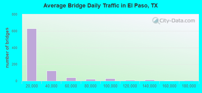
- 19,800,083Total average daily traffic
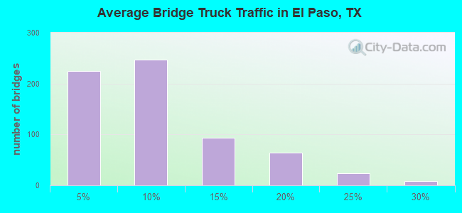
- 1,444,372Total average daily truck traffic
- National Bridge Inventory (NBI) Registered Bridges for El Paso
- No street view available for this location
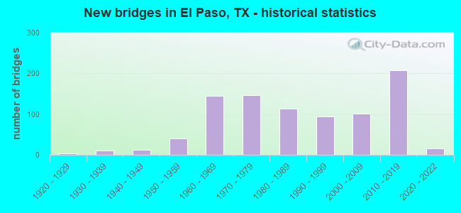
- New bridges - historical statistics
- 11910-1919
- 41920-1929
- 101930-1939
- 121940-1949
- 401950-1959
- 1441960-1969
- 1461970-1979
- 1131980-1989
- 941990-1999
- 1012000-2009
- 2072010-2019
- 162020-2022
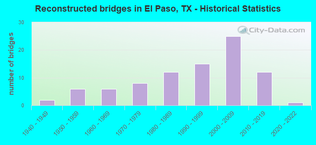
- Reconstructed bridges - Historical Statistics
- 21940-1949
- 61950-1959
- 61960-1969
- 81970-1979
- 121980-1989
- 151990-1999
- 252000-2009
- 122010-2019
- 12020-2022
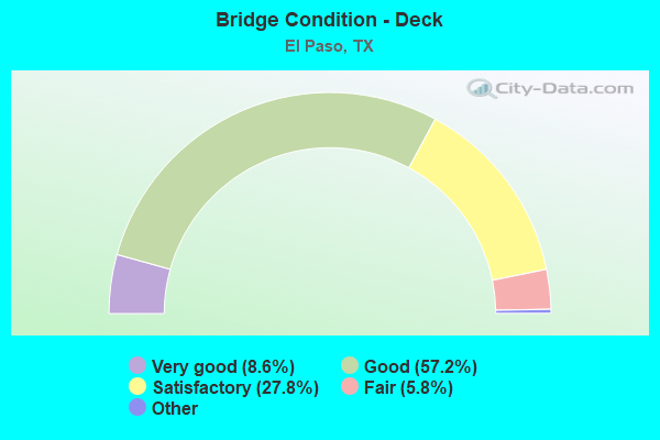
- Bridge Condition - Deck
- 8.6%Excellent
- 57.2%Very good
- 27.8%Good
- 5.8%Satisfactory
- 0.6%Fair
- 0.2%Poor
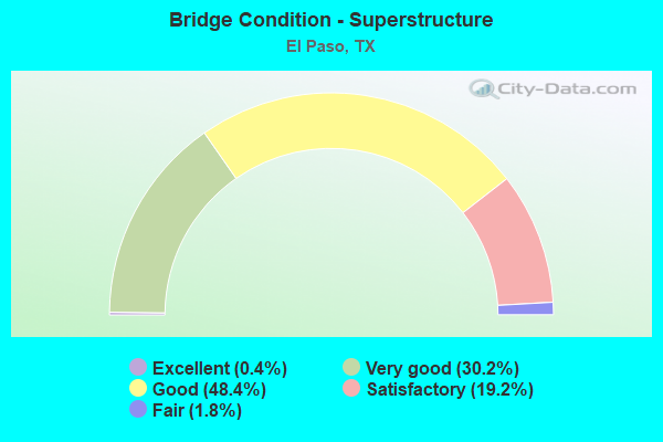
- Bridge Condition - Superstructure
- 0.4%Excellent
- 30.2%Very good
- 48.4%Good
- 19.2%Satisfactory
- 1.8%Fair
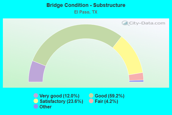
- Bridge Condition - Substructure
- 12.0%Excellent
- 59.2%Very good
- 23.6%Good
- 4.2%Satisfactory
- 1.0%Fair
- 0.6%Poor
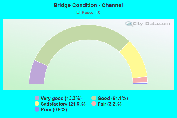
- Bridge Condition - Channel
- 13.3%Very good
- 61.1%Good
- 21.6%Satisfactory
- 3.2%Fair
- 0.9%Poor
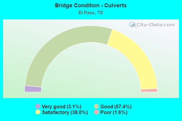
- Bridge Condition - Culverts
- 3.1%Very good
- 57.4%Good
- 38.0%Satisfactory
- 1.6%Poor
Find on map >> Show street view
Structure Number: 240720016701071, Location: JCT US 54 & LOOP 478 (Lat: 31.851156, Lng: -106.440211), Route carried "under" structure: State highway 54, Year Built: 1980, Structure Length: 0. m, Average Daily Traffic: 18,130 (year 2013), Truck Traffic: 10%, Features Intersected: DYER ST (LP 478)
Minimum Vertical Clearance: 6.53m (21.42ft), Kilometerpoint: 15.612, Lanes on structure: 3, Lanes under structure: 8, Material/Design: Prestressed concrete, Design/Construction: Stringer/Multi-beam, Length of Maximum Span: 33.5m (109.9ft)
Find on map >> Show street view
Structure Number: 240720016701072, Location: JCT US 54 & LOOP 478 (Lat: 31.851156, Lng: -106.440333), Route carried "under" structure: State highway 478, Year Built: 1980, Structure Length: 0. m, Average Daily Traffic: 14,090 (year 2013), Truck Traffic: 10%, Features Intersected: DYER ST (LP 478), Facility Carried by Structure: US 54 SB
Minimum Vertical Clearance: 5.59m (18.34ft), Kilometerpoint: 15.562, Lanes on structure: 3, Lanes under structure: 8, Material/Design: Prestressed concrete, Design/Construction: Stringer/Multi-beam, Length of Maximum Span: 33.5m (109.9ft)
Find on map >> Show street view
Structure Number: 240720016701073, Location: 0.2 MI N OF L478(DYER ST) (Lat: 31.854986, Lng: -106.440333), Route carried "under" structure: City street , Year Built: 1980, Structure Length: 0. m, Average Daily Traffic: 1,550 (year 2011), Features Intersected: HERCULES AVE, Facility Carried by Structure: US 54 NB
Minimum Vertical Clearance: 6.45m (21.16ft), Kilometerpoint: 1.328, Lanes on structure: 3, Lanes under structure: 5, Material/Design: Prestressed concrete, Design/Construction: Stringer/Multi-beam, Length of Maximum Span: 24.4m (80.1ft)
Find on map >> Show street view
Structure Number: 240720016701074, Location: 0.2 MI N OF L478(DYER ST) (Lat: 31.854975, Lng: -106.440442), Route carried "under" structure: City street , Year Built: 1980, Structure Length: 0. m, Average Daily Traffic: 1,550 (year 2011), Features Intersected: HERCULES AVE, Facility Carried by Structure: US 54 SB
Minimum Vertical Clearance: 5.13m (16.83ft), Kilometerpoint: 1.297, Lanes on structure: 3, Lanes under structure: 5, Material/Design: Prestressed concrete, Design/Construction: Stringer/Multi-beam, Length of Maximum Span: 24.4m (80.1ft)
Find on map >> Show street view
Structure Number: 240720016701076, Location: 1.2 MI N OF L478(DYER ST) (Lat: 31.869367, Lng: -106.440803), Route carried "under" structure: City street , Year Built: 1980, Structure Length: 0. m, Average Daily Traffic: 1,550 (year 2011), Features Intersected: HONDO PASS DR, Facility Carried by Structure: US 54 SB
Minimum Vertical Clearance: 5.33m (17.49ft), Kilometerpoint: 1.532, Lanes on structure: 3, Lanes under structure: 7, Material/Design: Prestressed concrete, Design/Construction: Stringer/Multi-beam, Length of Maximum Span: 24.4m (80.1ft)
Find on map >> Show street view
Structure Number: 240720016701077, Location: 1.2 MI N OF L478(DYER ST) (Lat: 31.869344, Lng: -106.440711), Route carried "under" structure: City street , Year Built: 1980, Structure Length: 0. m, Average Daily Traffic: 1,550 (year 2011), Features Intersected: HONDO PASS DR, Facility Carried by Structure: US 54 NB
Minimum Vertical Clearance: 6.35m (20.83ft), Kilometerpoint: 1.556, Lanes on structure: 2, Lanes under structure: 7, Material/Design: Prestressed concrete, Design/Construction: Stringer/Multi-beam, Length of Maximum Span: 24.4m (80.1ft)
Find on map >> Show street view
Structure Number: 240720016701086, Location: 2.2 MI N OF L478(DYER) (Lat: 31.882819, Lng: -106.441011), Route carried "under" structure: City street , Year Built: 1987, Structure Length: 0. m, Average Daily Traffic: 10,000 (year 2010), Features Intersected: DIANA DR, Facility Carried by Structure: US 54 SB
Minimum Vertical Clearance: 5.00m (16.40ft), Kilometerpoint: 0.050, Lanes on structure: 4, Lanes under structure: 6, Material/Design: Prestressed concrete, Design/Construction: Stringer/Multi-beam, Length of Maximum Span: 29.0m (95.1ft)
Find on map >> Show street view
Structure Number: 240720016701087, Location: 2.2 MI. N OF L478(DYER) (Lat: 31.882811, Lng: -106.440900), Route carried "under" structure: City street , Year Built: 1987, Structure Length: 0. m, Average Daily Traffic: 1,000 (year 2010), Features Intersected: DIANA DR, Facility Carried by Structure: US 54 NB
Minimum Vertical Clearance: 6.49m (21.29ft), Kilometerpoint: 0.066, Lanes on structure: 4, Lanes under structure: 6, Material/Design: Prestressed concrete, Design/Construction: Stringer/Multi-beam, Length of Maximum Span: 29.0m (95.1ft)
Find on map >> Show street view
Structure Number: 240720016701088, Location: 3.27 MI N OF BU 54 (DYER) (Lat: 31.899017, Lng: -106.441517), Route carried "under" structure: State highway 375, Year Built: 1987, Structure Length: 0. m, Average Daily Traffic: 16,720 (year 2017), Truck Traffic: 17%, Features Intersected: US 54 WB, Facility Carried by Structure: US 54 WB
Minimum Vertical Clearance: 5.21m (17.09ft), Kilometerpoint: 18.638, Lanes on structure: 3, Lanes under structure: 11, Material/Design: Prestressed concrete, Design/Construction: Stringer/Multi-beam, Length of Maximum Span: 33.5m (109.9ft)
Find on map >> Show street view
Structure Number: 240720016701089, Location: 3.27 MI N OF BU 54 (DYER) (Lat: 31.897961, Lng: -106.441206), Route carried "under" structure: State highway 375, Year Built: 1987, Structure Length: 0. m, Average Daily Traffic: 16,720 (year 2017), Truck Traffic: 17%, Features Intersected: US 54 EB, Facility Carried by Structure: US 54 EB
Minimum Vertical Clearance: 6.00m (19.69ft), Kilometerpoint: 18.680, Lanes on structure: 3, Lanes under structure: 11, Material/Design: Prestressed concrete, Design/Construction: Stringer/Multi-beam, Length of Maximum Span: 33.5m (109.9ft)
Find on map >> Show street view
Structure Number: 240720016701109, Location: 1.63 MI N OF LP 375 (Lat: 31.922919, Lng: -106.439689), Route carried "under" structure: State highway 3255, Year Built: 2005, Structure Length: 0. m, Average Daily Traffic: 1,000 (year 2017), Features Intersected: US 54 WB, Facility Carried by Structure: US 54 WB
Minimum Vertical Clearance: 6.17m (20.24ft), Kilometerpoint: 10.375, Lanes on structure: 2, Lanes under structure: 8, Material/Design: Prestressed concrete, Design/Construction: Stringer/Multi-beam, Length of Maximum Span: 30.5m (100.1ft)
Find on map >> Show street view
Structure Number: 240720016701112, Location: 0.19 MI N OF LP 375 (Lat: 31.901064, Lng: -106.441136), Route carried "under" structure: Ramp US 54, Year Built: 2005, Structure Length: 0. m, Average Daily Traffic: 1,000 (year 2017), Truck Traffic: 2%, Features Intersected: US 54 EB OFF-RAMP
Minimum Vertical Clearance: 6.53m (21.42ft), Kilometerpoint: 0.000, Lanes on structure: 1, Lanes under structure: 1, Material/Design: Prestressed concrete, Design/Construction: Box Beam or Girders - Multiple, Length of Maximum Span: 33.5m (109.9ft)
Find on map >> Show street view
Structure Number: 240720016701113, Location: 0.95 MI N OF LP 375 (Lat: 31.912525, Lng: -106.441525), Route carried "under" structure: City street , Year Built: 2005, Structure Length: 0. m, Average Daily Traffic: 1,000 (year 2017), Features Intersected: US 54 EB, Facility Carried by Structure: US 54 EB
Minimum Vertical Clearance: 6.73m (22.08ft), Kilometerpoint: 0.002, Lanes on structure: 2, Lanes under structure: 7, Material/Design: Prestressed concrete, Design/Construction: Stringer/Multi-beam, Length of Maximum Span: 28.7m (94.2ft)
Find on map >> Show street view
Structure Number: 240720016701114, Location: 1.63 MI N OF LP 375 (Lat: 31.922269, Lng: -106.439922), Route carried "under" structure: State highway 3255, Year Built: 2005, Structure Length: 0. m, Average Daily Traffic: 1,000 (year 2010), Features Intersected: US 54 EB, Facility Carried by Structure: US 54 EB
Minimum Vertical Clearance: 5.82m (19.09ft), Kilometerpoint: 10.393, Lanes on structure: 2, Lanes under structure: 8, Material/Design: Prestressed concrete, Design/Construction: Stringer/Multi-beam, Length of Maximum Span: 30.5m (100.1ft)
Find on map >> Show street view
Structure Number: 240720016701249, Location: 1.6 MI N OF IH 10 (Lat: 31.800589, Lng: -106.441722), Route carried "under" structure: County highway , Year Built: 1978, Structure Length: 0. m, Average Daily Traffic: 1,000 (year 2013), Features Intersected: PERSHING DR, Facility Carried by Structure: US 54 SB
Minimum Vertical Clearance: 5.05m (16.57ft), Kilometerpoint: 3.763, Lanes on structure: 6, Lanes under structure: 5, Material/Design: Prestressed concrete, Design/Construction: Stringer/Multi-beam, Length of Maximum Span: 25.9m (85.0ft)
Find on map >> Show street view
Structure Number: 24072001670125, Location: US 54 / SP 601 I/C (Lat: 31.824369, Lng: -106.436981), Route carried "under" structure: ServiceUS 54, Year Built: 2010, Structure Length: 0. m, Average Daily Traffic: 3,000 (year 2018), Truck Traffic: 5%, Features Intersected: US 54 NBFR GATEWAY NORTH
Minimum Vertical Clearance: 5.18m (16.99ft), Kilometerpoint: 14.967, Lanes on structure: 1, Lanes under structure: 2, Material/Design: Prestressed concrete, Design/Construction: Stringer/Multi-beam, Length of Maximum Span: 37.8m (124.0ft)
Find on map >> Show street view
Structure Number: 240720016701251, Location: US54 / SP601 INTERCHANGE (Lat: 31.826531, Lng: -106.438400), Route carried "under" structure: US 54, Year Built: 2010, Structure Length: 0. m, Average Daily Traffic: 1 (year 2010), Truck Traffic: 5%, Features Intersected: US 54
Minimum Vertical Clearance: 6.12m (20.08ft), Kilometerpoint: 15.718, Lanes on structure: 1, Lanes under structure: 6, Material/Design: Steel continuous, Design/Construction: Stringer/Multi-beam, Length of Maximum Span: 69.5m (228.0ft)
Find on map >> Show street view
Structure Number: 240720016701252, Location: 3.27 MI N OF BU 54 (DYER) (Lat: 31.898536, Lng: -106.441933), Route carried "under" structure: State highway 375, Year Built: 2011, Structure Length: 0. m, Average Daily Traffic: 16,720 (year 2017), Truck Traffic: 17%, Features Intersected: US 54 WBFR, Facility Carried by Structure: US 54 SBFR
Minimum Vertical Clearance: 5.69m (18.67ft), Kilometerpoint: 0.000, Lanes on structure: 4, Lanes under structure: 4, Material/Design: Prestressed concrete, Design/Construction: Stringer/Multi-beam, Length of Maximum Span: 27.7m (90.9ft)
Find on map >> Show street view
Structure Number: 240720016701253, Location: 3.27 MI N OF BU 54 (DYER) (Lat: 31.898553, Lng: -106.440817), Route carried "under" structure: State highway 375, Year Built: 2011, Structure Length: 0. m, Average Daily Traffic: 16,720 (year 2017), Truck Traffic: 17%, Features Intersected: US 54 EBFR, Facility Carried by Structure: US 54 NBFR
Minimum Vertical Clearance: 5.64m (18.50ft), Kilometerpoint: 0.000, Lanes on structure: 4, Lanes under structure: 4, Material/Design: Prestressed concrete, Design/Construction: Stringer/Multi-beam, Length of Maximum Span: 28.0m (91.9ft)
Find on map >> Show street view
Structure Number: 240720016701254, Location: 3.27 MI N OF BU 54 (DYER) (Lat: 31.898547, Lng: -106.440644), Route carried "under" structure: State highway 375, Year Built: 2011, Structure Length: 0. m, Average Daily Traffic: 16,720 (year 2017), Truck Traffic: 17%, Features Intersected: LP 375 E T/A
Minimum Vertical Clearance: 5.61m (18.41ft), Kilometerpoint: 0.000, Lanes on structure: 1, Lanes under structure: 4, Material/Design: Prestressed concrete, Design/Construction: Stringer/Multi-beam, Length of Maximum Span: 28.3m (92.8ft)
Find on map >> Show street view
Structure Number: 240720016701256, Location: 0.3 Mi S of Int IH 110 EB (Lat: 31.767494, Lng: -106.446831), Route carried "under" structure: US 62, Year Built: 2021, Structure Length: 0. m, Average Daily Traffic: 10,900 (year 2019), Truck Traffic: 5%, Features Intersected: US 62, Facility Carried by Structure: LP375EB to IH110EB
Minimum Vertical Clearance: 5.77m (18.93ft), Kilometerpoint: 2.736, Lanes on structure: 1, Lanes under structure: 11, Material/Design: Prestressed concrete, Design/Construction: Stringer/Multi-beam, Length of Maximum Span: 39.6m (129.9ft)
Find on map >> Show street view
Structure Number: 240720016701257, Location: 0.2 MI W of US 54 (Lat: 31.769278, Lng: -106.450331), Route carried "under" structure: Interstate 62, Year Built: 2021, Structure Length: 0. m, Average Daily Traffic: 10,450 (year 2022), Truck Traffic: 4%, Features Intersected: IH 110
Minimum Vertical Clearance: 7.85m (25.75ft), Kilometerpoint: 0.000, Lanes on structure: 4, Lanes under structure: 8, Material/Design: Prestressed concrete, Design/Construction: Stringer/Multi-beam, Length of Maximum Span: 38.1m (125.0ft)
Find on map >> Show street view
Structure Number: 240720016701258, Location: 0.2 MI W of US 54 (Lat: 31.769269, Lng: -106.450225), Route carried "under" structure: Interstate 110, Year Built: 2021, Structure Length: 0. m, Average Daily Traffic: 6,550 (year 2022), Truck Traffic: 4%, Features Intersected: IH 110, Facility Carried by Structure: US 62 WB
Minimum Vertical Clearance: 7.93m (26.02ft), Kilometerpoint: 0.000, Lanes on structure: 3, Lanes under structure: 8, Material/Design: Prestressed concrete, Design/Construction: Stringer/Multi-beam, Length of Maximum Span: 38.1m (125.0ft)
Find on map >> Show street view
Structure Number: 240720016701259, Location: 0.5 Mi N of US62(Paisano) (Lat: 31.773375, Lng: -106.445600), Route carried "under" structure: State highway 20, Year Built: 2021, Structure Length: 0. m, Average Daily Traffic: 11,700 (year 2019), Truck Traffic: 4%, Features Intersected: Alameda Ave, Facility Carried by Structure: IH 110 WB
Minimum Vertical Clearance: 6.61m (21.69ft), Kilometerpoint: 0.000, Lanes on structure: 2, Lanes under structure: 4, Material/Design: Prestressed concrete, Design/Construction: Stringer/Multi-beam, Length of Maximum Span: 33.5m (109.9ft)
Find on map >> Show street view
Structure Number: 240720016704078, Location: 0.70 MI S OF IH 10 (Lat: 31.768072, Lng: -106.447064), Route carried "under" structure: US 62, Year Built: 1981, Structure Length: 0. m, Average Daily Traffic: 13,280 (year 2013), Truck Traffic: 11%, Features Intersected: US 62 (PAISANO), Facility Carried by Structure: US 54 NB
Minimum Vertical Clearance: 5.36m (17.59ft), Kilometerpoint: 13.562, Lanes on structure: 3, Lanes under structure: 10, Material/Design: Prestressed concrete, Design/Construction: Stringer/Multi-beam, Length of Maximum Span: 24.4m (80.1ft)
Find on map >> Show street view
Structure Number: 240720016704079, Location: US 54 AT LP 375 (Lat: 31.763950, Lng: -106.446678), Route carried "under" structure: City street , Year Built: 1981, Structure Length: 0. m, Average Daily Traffic: 1,000 (year 2009), Features Intersected: DELTA DR, Facility Carried by Structure: LP375WB TO US54 EB
Minimum Vertical Clearance: 4.67m (15.32ft), Kilometerpoint: 3.314, Lanes on structure: 2, Lanes under structure: 5, Material/Design: Prestressed concrete, Design/Construction: Stringer/Multi-beam, Length of Maximum Span: 34.7m (113.8ft)
Find on map >> Show street view
Structure Number: 24072001670408, Location: US 54 AT LP 375 (Lat: 31.764872, Lng: -106.447739), Route carried "under" structure: State highway 375, Year Built: 1981, Structure Length: 0. m, Average Daily Traffic: 41,780 (year 2011), Truck Traffic: 4%, Features Intersected: LP 375
Minimum Vertical Clearance: 5.11m (16.77ft), Kilometerpoint: 16.198, Lanes on structure: 2, Lanes under structure: 9, Material/Design: Steel continuous, Design/Construction: Stringer/Multi-beam, Length of Maximum Span: 40.2m (131.9ft)
Find on map >> Show street view
Structure Number: 24072001670408, Location: US 54 AT LP 375 (Lat: 31.764872, Lng: -106.447739), Route carried "under" structure: City street , Year Built: 1981, Structure Length: 0. m, Average Daily Traffic: 41,780 (year 2011), Truck Traffic: 4%, Features Intersected: DELTA DR, Facility Carried by Structure: US 54WB TO LP375EB
Minimum Vertical Clearance: 5.11m (16.77ft), Kilometerpoint: 16.198, Lanes on structure: 2, Lanes under structure: 9, Material/Design: Steel continuous, Design/Construction: Stringer/Multi-beam, Length of Maximum Span: 40.2m (131.9ft)
Find on map >> Show street view
Structure Number: 240720016704081, Location: US 54 AT LOOP 375 (Lat: 31.764389, Lng: -106.449431), Route carried "under" structure: City street , Year Built: 1981, Structure Length: 0. m, Average Daily Traffic: 24,991 (year 2013), Truck Traffic: 4%, Features Intersected: DELTA DR, Facility Carried by Structure: LP375EB TO US54 NB
Minimum Vertical Clearance: 7.62m (25.00ft), Kilometerpoint: 16.198, Lanes on structure: 1, Lanes under structure: 14, Material/Design: Prestressed concrete, Design/Construction: Stringer/Multi-beam, Length of Maximum Span: 28.0m (91.9ft)
Find on map >> Show street view
Structure Number: 240720016704081, Location: US 54 AT LOOP 375 (Lat: 31.764389, Lng: -106.449431), Route carried "under" structure: Spur State highway 375, Year Built: 1981, Structure Length: 0. m, Average Daily Traffic: 24,991 (year 2013), Truck Traffic: 4%, Features Intersected: LP 375
Minimum Vertical Clearance: 7.62m (25.00ft), Kilometerpoint: 16.198, Lanes on structure: 1, Lanes under structure: 14, Material/Design: Prestressed concrete, Design/Construction: Stringer/Multi-beam, Length of Maximum Span: 28.0m (91.9ft)
Find on map >> Show street view
Structure Number: 240720016704081, Location: US 54 AT LOOP 375 (Lat: 31.764389, Lng: -106.449431), Route carried "under" structure: Ramp State highway 54, Year Built: 1981, Structure Length: 0. m, Average Daily Traffic: 1,150 (year 2013), Truck Traffic: 8%, Features Intersected: US 54WB TO LP375EB
Minimum Vertical Clearance: 6.10m (20.01ft), Kilometerpoint: 16.198, Lanes on structure: 1, Lanes under structure: 14, Material/Design: Prestressed concrete, Design/Construction: Stringer/Multi-beam, Length of Maximum Span: 28.0m (91.9ft)
Find on map >> Show street view
Structure Number: 240720016704081, Location: US 54 AT LOOP 375 (Lat: 31.764389, Lng: -106.449431), Route carried "under" structure: Ramp State highway 54, Year Built: 1981, Structure Length: 0. m, Average Daily Traffic: 1,150 (year 2013), Truck Traffic: 8%, Features Intersected: LP375WB TO US54 EB
Minimum Vertical Clearance: 5.30m (17.39ft), Kilometerpoint: 16.198, Lanes on structure: 1, Lanes under structure: 14, Material/Design: Prestressed concrete, Design/Construction: Stringer/Multi-beam, Length of Maximum Span: 28.0m (91.9ft)
Find on map >> Show street view
Structure Number: 240720016704082, Location: US 54 AT LP 375 (Lat: 31.765508, Lng: -106.447992), Route carried "under" structure: Ramp State highway 375, Year Built: 1981, Structure Length: 0. m, Average Daily Traffic: 2,070 (year 2011), Truck Traffic: 10%, Features Intersected: RAMP E
Minimum Vertical Clearance: 4.88m (16.01ft), Kilometerpoint: 3.098, Lanes on structure: 1, Lanes under structure: 6, Material/Design: Steel continuous, Design/Construction: Stringer/Multi-beam, Length of Maximum Span: 40.2m (131.9ft)
Find on map >> Show street view
Structure Number: 240720016704082, Location: US 54 AT LP 375 (Lat: 31.765508, Lng: -106.447992), Route carried "under" structure: City street , Year Built: 1981, Structure Length: 0. m, Average Daily Traffic: 1,000 (year 2009), Features Intersected: DELTA DR, Facility Carried by Structure: US54 SB TO L375 WB
Minimum Vertical Clearance: 5.56m (18.24ft), Kilometerpoint: 3.098, Lanes on structure: 1, Lanes under structure: 6, Material/Design: Steel continuous, Design/Construction: Stringer/Multi-beam, Length of Maximum Span: 40.2m (131.9ft)
Find on map >> Show street view
Structure Number: 240720016704083, Location: JCT US 54 & LOOP 375 (Lat: 31.764192, Lng: -106.446572), Route carried "under" structure: City street , Year Built: 1981, Structure Length: 0. m, Average Daily Traffic: 1,000 (year 2010), Features Intersected: DELTA DR, Facility Carried by Structure: US 54 EB OFF-RP F
Minimum Vertical Clearance: 5.16m (16.93ft), Kilometerpoint: 3.098, Lanes on structure: 1, Lanes under structure: 5, Material/Design: Prestressed concrete, Design/Construction: Stringer/Multi-beam, Length of Maximum Span: 34.7m (113.8ft)
Find on map >> Show street view
Structure Number: 240720016704115, Location: 0.70 MI S OF IH 10 (Lat: 31.768122, Lng: -106.447242), Route carried "under" structure: US 62, Year Built: 1981, Structure Length: 0. m, Average Daily Traffic: 16,670 (year 2010), Truck Traffic: 8%, Features Intersected: US 62 (PAISANO), Facility Carried by Structure: US 54 SB
Minimum Vertical Clearance: 5.36m (17.59ft), Kilometerpoint: 13.520, Lanes on structure: 2, Lanes under structure: 10, Material/Design: Prestressed concrete, Design/Construction: Stringer/Multi-beam, Length of Maximum Span: 24.4m (80.1ft)
Find on map >> Show street view
Structure Number: 240720037402084, Location: JCT. OF US 62 & LP 375 (Lat: 31.806589, Lng: -106.268119), Route carried "under" structure: US 62, Year Built: 2003, Structure Length: 0. m, Average Daily Traffic: 28,000 (year 2010), Truck Traffic: 18%, Features Intersected: US 62, Facility Carried by Structure: LP 375
Minimum Vertical Clearance: 5.87m (19.26ft), Kilometerpoint: 34.557, Lanes on structure: 4, Lanes under structure: 8, Material/Design: Steel continuous, Design/Construction: Stringer/Multi-beam, Length of Maximum Span: 45.7m (149.9ft)
Find on map >> Show street view
Structure Number: 240720037402112, Location: 3.30 MI E OF LP 375 (Lat: 31.813761, Lng: -106.212900), Route carried "under" structure: State highway 659, Year Built: 2010, Structure Length: 0. m, Average Daily Traffic: 18,397 (year 2018), Truck Traffic: 7%, Features Intersected: FM 659, Facility Carried by Structure: US 62/180
Minimum Vertical Clearance: 5.77m (18.93ft), Kilometerpoint: 0.000, Lanes on structure: 4, Lanes under structure: 4, Material/Design: Prestressed concrete, Design/Construction: Stringer/Multi-beam, Length of Maximum Span: 45.7m (149.9ft)
Find on map >> Show street view
Structure Number: 240720104603112, Location: 1.90 MI E OF US 54 (Lat: 31.825250, Lng: -106.404861), Route carried "under" structure: City street , Year Built: 2011, Structure Length: 0. m, Average Daily Traffic: 2,000 (year 2018), Truck Traffic: 4%, Features Intersected: AIRPORT DR NB, Facility Carried by Structure: SPUR 601 WB
Minimum Vertical Clearance: 7.16m (23.49ft), Kilometerpoint: 0.161, Lanes on structure: 3, Lanes under structure: 2, Material/Design: Steel, Design/Construction: Stringer/Multi-beam, Length of Maximum Span: 54.9m (180.1ft)
Find on map >> Show street view
Structure Number: 240720104603118, Location: 1.0 MI W OF LOOP 375 SB (Lat: 31.840919, Lng: -106.342050), Route carried "under" structure: County highway , Year Built: 2010, Structure Length: 0. m, Average Daily Traffic: 1,900 (year 2010), Truck Traffic: 1%, Features Intersected: CONSTITUTION AVE, Facility Carried by Structure: SPUR 601
Minimum Vertical Clearance: 5.13m (16.83ft), Kilometerpoint: 0.161, Lanes on structure: 4, Lanes under structure: 6, Material/Design: Prestressed concrete, Design/Construction: Stringer/Multi-beam, Length of Maximum Span: 27.7m (90.9ft)
Find on map >> Show street view
Structure Number: 240720104603121, Location: 4.5 MI N OF US 62/180 (Lat: 31.841131, Lng: -106.324439), Route carried "under" structure: State highway 601, Year Built: 2010, Structure Length: 0. m, Average Daily Traffic: 25,928 (year 2018), Truck Traffic: 5%, Features Intersected: SP 601, Facility Carried by Structure: LP 375 NB
Minimum Vertical Clearance: 5.16m (16.93ft), Kilometerpoint: 11.748, Lanes on structure: 2, Lanes under structure: 4, Material/Design: Prestressed concrete, Design/Construction: Stringer/Multi-beam, Length of Maximum Span: 39.3m (128.9ft)
Find on map >> Show street view
Structure Number: 240720104603127, Location: 0.10 MI E OF US 54 (Lat: 31.825922, Lng: -106.435664), Route carried "under" structure: City street , Year Built: 2010, Structure Length: 0. m, Average Daily Traffic: 17,800 (year 2017), Truck Traffic: 5%, Features Intersected: SPUR 601, Facility Carried by Structure: SPUR 601
Minimum Vertical Clearance: 5.61m (18.41ft), Kilometerpoint: 0.000, Lanes on structure: 6, Lanes under structure: 13, Material/Design: Prestressed concrete, Design/Construction: Stringer/Multi-beam, Length of Maximum Span: 38.4m (126.0ft)
Find on map >> Show street view
Structure Number: 240720104603128, Location: 1.7 MI S OF US478/54BUSIN (Lat: 31.826189, Lng: -106.435081), Route carried "under" structure: City street , Year Built: 2010, Structure Length: 0. m, Average Daily Traffic: 1 (year 2010), Truck Traffic: 1%, Features Intersected: RAILROAD DR, Facility Carried by Structure: SP 601 WB Conn W N
Minimum Vertical Clearance: 7.06m (23.16ft), Kilometerpoint: 0.000, Lanes on structure: 1, Lanes under structure: 4, Material/Design: Prestressed concrete, Design/Construction: Stringer/Multi-beam, Length of Maximum Span: 38.4m (126.0ft)
Find on map >> Show street view
Structure Number: 240720104603129, Location: US 54 / SP 601 I/C (Lat: 31.824861, Lng: -106.437800), Route carried "under" structure: US 54, Year Built: 2010, Structure Length: 0. m, Average Daily Traffic: 60,000 (year 2018), Truck Traffic: 1%, Features Intersected: US 54, Facility Carried by Structure: SP 601 WB CONN W-S
Minimum Vertical Clearance: 6.02m (19.75ft), Kilometerpoint: 15.043, Lanes on structure: 1, Lanes under structure: 6, Material/Design: Steel continuous, Design/Construction: Stringer/Multi-beam, Length of Maximum Span: 80.5m (264.1ft)
Find on map >> Show street view
Structure Number: 24072010460313, Location: 4.5 MI N OF US 62/180 (Lat: 31.841239, Lng: -106.324789), Route carried "under" structure: State highway 601, Year Built: 2010, Structure Length: 0. m, Average Daily Traffic: 25,928 (year 2018), Truck Traffic: 7%, Features Intersected: SP 601, Facility Carried by Structure: LP 375 SB
Minimum Vertical Clearance: 5.16m (16.93ft), Kilometerpoint: 11.748, Lanes on structure: 2, Lanes under structure: 6, Material/Design: Prestressed concrete, Design/Construction: Stringer/Multi-beam, Length of Maximum Span: 39.3m (128.9ft)
Find on map >> Show street view
Structure Number: 240720212101232, Location: 10.3 MI S OF NEW MEX S/L (Lat: 31.852475, Lng: -106.574375), Route carried "under" structure: Interstate 10, Year Built: 1980, Structure Length: 0. m, Average Daily Traffic: 84,500 (year 2013), Truck Traffic: 15%, Features Intersected: IH 10, Facility Carried by Structure: THORN RD
Minimum Vertical Clearance: 5.21m (17.09ft), Kilometerpoint: 16.472, Lanes on structure: 3, Lanes under structure: 5, Material/Design: Prestressed concrete, Design/Construction: Box Beam or Girders - Multiple, Length of Maximum Span: 25.9m (85.0ft)
Find on map >> Show street view
Structure Number: 240720212101251, Location: 3.088 MI N OF SH20 (Lat: 31.882922, Lng: -106.582281), Route carried "under" structure: State highway 10, Year Built: 1998, Structure Length: 0. m, Average Daily Traffic: 58,770 (year 2013), Truck Traffic: 14%, Features Intersected: IH 10, Facility Carried by Structure: SH 178 (ARTCRAFT)
Minimum Vertical Clearance: 5.09m (16.70ft), Kilometerpoint: 13.013, Lanes on structure: 7, Lanes under structure: 4, Material/Design: Prestressed concrete, Design/Construction: Stringer/Multi-beam, Length of Maximum Span: 36.6m (120.1ft)
Find on map >> Show street view
Structure Number: 240720212101252, Location: 9.5 MI S OF NM S/L (Lat: 31.863858, Lng: -106.577403), Route carried "under" structure: State highway 1905, Year Built: 1998, Structure Length: 0. m, Average Daily Traffic: 8,000 (year 2011), Features Intersected: REDD RD, Facility Carried by Structure: IH 10
Minimum Vertical Clearance: 5.92m (19.42ft), Kilometerpoint: 3.787, Lanes on structure: 4, Lanes under structure: 8, Material/Design: Prestressed concrete, Design/Construction: Stringer/Multi-beam, Length of Maximum Span: 32.9m (107.9ft)
Find on map >> Show street view
Structure Number: 240720212101268, Location: 6.30 MI S OF NM S/L (Lat: 31.908647, Lng: -106.582514), Route carried "under" structure: Interstate 10, Year Built: 2005, Structure Length: 0. m, Average Daily Traffic: 38,140 (year 2017), Truck Traffic: 22%, Features Intersected: LP 375, Facility Carried by Structure: LP 375 WB
Minimum Vertical Clearance: 5.13m (16.83ft), Kilometerpoint: 10.223, Lanes on structure: 4, Lanes under structure: 4, Material/Design: Prestressed concrete, Design/Construction: Stringer/Multi-beam, Length of Maximum Span: 30.5m (100.1ft)
Find on map >> Show street view
Structure Number: 240720212101269, Location: 6.30 MI S OF NM S/L (Lat: 31.908214, Lng: -106.583139), Route carried "under" structure: Interstate 10, Year Built: 2005, Structure Length: 0. m, Average Daily Traffic: 38,980 (year 2017), Truck Traffic: 17%, Features Intersected: LP 375 EB, Facility Carried by Structure: LP 375 EB
Minimum Vertical Clearance: 5.41m (17.75ft), Kilometerpoint: 10.247, Lanes on structure: 4, Lanes under structure: 4, Material/Design: Prestressed concrete, Design/Construction: Stringer/Multi-beam, Length of Maximum Span: 30.5m (100.1ft)
Find on map >> Show street view
Structure Number: 240720212101289, Location: LP375@IH10 INTERCHANGE (Lat: 31.908519, Lng: -106.576717), Route carried "under" structure: Interstate 10, Year Built: 2013, Structure Length: 0. m, Average Daily Traffic: 17,500 (year 2017), Truck Traffic: 17%, Features Intersected: LP 375 WB CONN TO IH 10
Minimum Vertical Clearance: 10.24m (33.60ft), Kilometerpoint: 0.000, Lanes on structure: 1, Lanes under structure: 19, Material/Design: Steel continuous, Design/Construction: Stringer/Multi-beam, Length of Maximum Span: 79.2m (259.8ft)
Find on map >> Show street view
Structure Number: 24072021210129, Location: IH 10/ LP 375 INTERCHANGE (Lat: 31.902489, Lng: -106.582503), Route carried "under" structure: ServiceInterstate 10, Year Built: 2013, Structure Length: 0. m, Average Daily Traffic: 8,100 (year 2017), Features Intersected: IH 10 WB CONN TO LP 375
Minimum Vertical Clearance: 5.33m (17.49ft), Kilometerpoint: 0.000, Lanes on structure: 1, Lanes under structure: 7, Material/Design: Steel continuous, Design/Construction: Stringer/Multi-beam, Length of Maximum Span: 77.7m (254.9ft)
Find on map >> Show street view
Structure Number: 240720212101311, Location: IH 10 AT SH 20 (MESA) (Lat: 31.840642, Lng: -106.571014), Route carried "under" structure: State highway 20, Year Built: 2017, Structure Length: 0. m, Average Daily Traffic: 33,990 (year 2013), Truck Traffic: 5%, Features Intersected: SH 20 (MESA) & DRAIN, Facility Carried by Structure: IH 10
Minimum Vertical Clearance: 5.44m (17.85ft), Kilometerpoint: 18.876, Lanes on structure: 4, Lanes under structure: 12, Material/Design: Prestressed concrete, Design/Construction: Stringer/Multi-beam, Length of Maximum Span: 50.0m (164.0ft)
Find on map >> Show street view
Structure Number: 240720212101348, Location: 1.24 MI E. OF SH 20 (Lat: 31.957900, Lng: -106.582750), Route carried "under" structure: ServiceInterstate 10, Year Built: 2019, Structure Length: 0. m, Average Daily Traffic: 53,869 (year 2017), Truck Traffic: 1%, Features Intersected: IH 10, Facility Carried by Structure: NORTH T/A SPUR 37
Minimum Vertical Clearance: 30+ m (98+ ft), Kilometerpoint: 4.828, Lanes on structure: 1, Lanes under structure: 4, Material/Design: Prestressed concrete, Design/Construction: Stringer/Multi-beam, Length of Maximum Span: 36.6m (120.1ft)
Find on map >> Show street view
Structure Number: 240720212102159, Location: 0.2 MI W OF US 62 (Lat: 31.777369, Lng: -106.425450), Route carried "under" structure: City street , Year Built: 1962, Structure Length: 0. m, Average Daily Traffic: 2,000 (year 2011), Truck Traffic: 2%, Features Intersected: CHELSEA DRIVE, Facility Carried by Structure: IH 10 WB
Minimum Vertical Clearance: 4.60m (15.09ft), Kilometerpoint: 1.679, Lanes on structure: 5, Lanes under structure: 4, Material/Design: Prestressed concrete, Design/Construction: Stringer/Multi-beam, Length of Maximum Span: 19.8m (65.0ft)
Find on map >> Show street view
Structure Number: 24072021210216, Location: 0.2 MI W OF US 62 (Lat: 31.777269, Lng: -106.425450), Route carried "under" structure: City street , Year Built: 1962, Structure Length: 0. m, Average Daily Traffic: 2,000 (year 2011), Truck Traffic: 2%, Features Intersected: CHELSEA DRIVE, Facility Carried by Structure: IH 10 EB
Minimum Vertical Clearance: 4.85m (15.91ft), Kilometerpoint: 1.679, Lanes on structure: 4, Lanes under structure: 4, Material/Design: Prestressed concrete, Design/Construction: Stringer/Multi-beam, Length of Maximum Span: 19.8m (65.0ft)
Find on map >> Show street view
Structure Number: 240720212102161, Location: 1.23 MI E OF US 54 (Lat: 31.777519, Lng: -106.422092), Route carried "under" structure: US 62, Year Built: 1962, Structure Length: 0. m, Average Daily Traffic: 32,780 (year 2013), Truck Traffic: 11%, Features Intersected: US 62 (PAISANO), Facility Carried by Structure: IH 10
Minimum Vertical Clearance: 4.70m (15.42ft), Kilometerpoint: 16.629, Lanes on structure: 8, Lanes under structure: 7, Material/Design: Prestressed concrete, Design/Construction: Stringer/Multi-beam, Length of Maximum Span: 19.8m (65.0ft)
Find on map >> Show street view
Structure Number: 240720212102168, Location: 1.7 MI W OF US 62 (Lat: 31.778217, Lng: -106.450886), Route carried "under" structure: Business State highway 478, Year Built: 1963, Structure Length: 0. m, Average Daily Traffic: 10,890 (year 2013), Truck Traffic: 10%, Features Intersected: COPIA STREET (LOOP 478), Facility Carried by Structure: IH10 WB
Minimum Vertical Clearance: 5.01m (16.44ft), Kilometerpoint: 0.982, Lanes on structure: 6, Lanes under structure: 5, Material/Design: Prestressed concrete, Design/Construction: Stringer/Multi-beam, Length of Maximum Span: 18.3m (60.0ft)
Find on map >> Show street view
Structure Number: 240720212102169, Location: 1.7 MI W OF US 62 (Lat: 31.777986, Lng: -106.450903), Route carried "under" structure: Business State highway 478, Year Built: 1963, Structure Length: 0. m, Average Daily Traffic: 8,220 (year 2013), Truck Traffic: 10%, Features Intersected: COPIA STREET (LOOP 478), Facility Carried by Structure: IH10 EB
Minimum Vertical Clearance: 5.03m (16.50ft), Kilometerpoint: 0.966, Lanes on structure: 3, Lanes under structure: 5, Material/Design: Prestressed concrete, Design/Construction: Stringer/Multi-beam, Length of Maximum Span: 18.3m (60.0ft)
Find on map >> Show street view
Structure Number: 240720212102174, Location: 0.7 MI W OF US 62 (Lat: 31.777167, Lng: -106.432792), Route carried "under" structure: Interstate 10, Year Built: 1963, Structure Length: 0. m, Average Daily Traffic: 185,240 (year 2013), Truck Traffic: 6%, Features Intersected: IH 10, Facility Carried by Structure: RAYNOLDS ST.
Minimum Vertical Clearance: 5.28m (17.32ft), Kilometerpoint: 38.561, Lanes on structure: 4, Lanes under structure: 10, Material/Design: Steel continuous, Design/Construction: Stringer/Multi-beam, Length of Maximum Span: 23.2m (76.1ft)
Find on map >> Show street view
Structure Number: 240720212102175, Location: 0.21 MI E OF SH 20 (MESA) (Lat: 31.764606, Lng: -106.487033), Route carried "under" structure: Interstate 10, Year Built: 1968, Structure Length: 0. m, Average Daily Traffic: 175,410 (year 2013), Truck Traffic: 9%, Features Intersected: IH 10, Facility Carried by Structure: WYOMING AVE
Minimum Vertical Clearance: 5.89m (19.32ft), Kilometerpoint: 31.566, Lanes on structure: 1, Lanes under structure: 10, Material/Design: Steel continuous, Design/Construction: Stringer/Multi-beam, Length of Maximum Span: 27.1m (88.9ft)
Find on map >> Show street view
Structure Number: 240720212102176, Location: 0.22 MI E OF SH 20 (Lat: 31.764058, Lng: -106.486492), Route carried "under" structure: Interstate 10, Year Built: 1968, Structure Length: 0. m, Average Daily Traffic: 175,410 (year 2013), Truck Traffic: 9%, Features Intersected: IH 10, Facility Carried by Structure: E MISSOURI AVE
Minimum Vertical Clearance: 5.18m (16.99ft), Kilometerpoint: 31.661, Lanes on structure: 4, Lanes under structure: 10, Material/Design: Steel continuous, Design/Construction: Stringer/Multi-beam, Length of Maximum Span: 32.0m (105.0ft)
Find on map >> Show street view
Structure Number: 240720212102177, Location: 1.10 MI W OF US 54 (Lat: 31.777903, Lng: -106.461950), Route carried "under" structure: City street , Year Built: 1968, Structure Length: 0. m, Average Daily Traffic: 1,000 (year 2009), Features Intersected: PEIDRAS ST, Facility Carried by Structure: IH 10 EB
Minimum Vertical Clearance: 4.60m (15.09ft), Kilometerpoint: 4.479, Lanes on structure: 6, Lanes under structure: 6, Material/Design: Steel continuous, Design/Construction: Stringer/Multi-beam, Length of Maximum Span: 28.3m (92.8ft)
Find on map >> Show street view
Structure Number: 240720212102178, Location: 1.00 MI W OF US 54 (Lat: 31.777942, Lng: -106.460253), Route carried "under" structure: City street , Year Built: 1968, Structure Length: 0. m, Average Daily Traffic: 1,000 (year 2009), Features Intersected: RAYNOR ST, Facility Carried by Structure: IH 10 EB
Minimum Vertical Clearance: 5.44m (17.85ft), Kilometerpoint: 0.925, Lanes on structure: 6, Lanes under structure: 5, Material/Design: Prestressed concrete, Design/Construction: Stringer/Multi-beam, Length of Maximum Span: 20.7m (67.9ft)
Find on map >> Show street view
Structure Number: 240720212102184, Location: 1.95 MI W OF US 54 (Lat: 31.771947, Lng: -106.473042), Route carried "under" structure: City street , Year Built: 1968, Structure Length: 0. m, Average Daily Traffic: 10,000 (year 2009), Features Intersected: COTTON AVE & UPRR, Facility Carried by Structure: IH 10 EB
Minimum Vertical Clearance: 5.11m (16.77ft), Kilometerpoint: 1.780, Lanes on structure: 5, Lanes under structure: 9, Material/Design: Steel, Design/Construction: Stringer/Multi-beam, Length of Maximum Span: 29.0m (95.1ft)
Find on map >> Show street view
Structure Number: 240720212102185, Location: 5.7 MI W OF US 62 (Lat: 31.766128, Lng: -106.507872), Route carried "under" structure: City street , Year Built: 1968, Structure Length: 0. m, Average Daily Traffic: 1,000 (year 2009), Features Intersected: SCHUSTER ST, Facility Carried by Structure: IH 10 EB
Minimum Vertical Clearance: 4.72m (15.49ft), Kilometerpoint: 0.080, Lanes on structure: 4, Lanes under structure: 3, Material/Design: Steel continuous, Design/Construction: Stringer/Multi-beam, Length of Maximum Span: 23.2m (76.1ft)
Find on map >> Show street view
Structure Number: 240720212102187, Location: 0.75 MI W OF SH 20(MESA) (Lat: 31.759858, Lng: -106.502414), Route carried "under" structure: Interstate 10, Year Built: 1968, Structure Length: 0. m, Average Daily Traffic: 131,860 (year 2013), Truck Traffic: 9%, Features Intersected: IH 10, Facility Carried by Structure: PORFIRIO DIAZ ST
Minimum Vertical Clearance: 6.53m (21.42ft), Kilometerpoint: 30.090, Lanes on structure: 2, Lanes under structure: 8, Material/Design: Steel continuous, Design/Construction: Stringer/Multi-beam, Length of Maximum Span: 29.6m (97.1ft)
Find on map >> Show street view
Structure Number: 240720212102188, Location: 0.45 MI SW OF SH20 (MESA) (Lat: 31.759361, Lng: -106.496589), Route carried "under" structure: City street , Year Built: 1968, Structure Length: 0. m, Average Daily Traffic: 1,550 (year 2011), Features Intersected: FRANKLIN AVE, Facility Carried by Structure: IH 10 EB
Minimum Vertical Clearance: 5.05m (16.57ft), Kilometerpoint: 0.119, Lanes on structure: 4, Lanes under structure: 2, Material/Design: Prestressed concrete, Design/Construction: Stringer/Multi-beam, Length of Maximum Span: 19.8m (65.0ft)
Find on map >> Show street view
Structure Number: 240720212102189, Location: 0.25 MI SW OF SH20 (MESA) (Lat: 31.760378, Lng: -106.493983), Route carried "under" structure: Interstate 10, Year Built: 1968, Structure Length: 0. m, Average Daily Traffic: 131,860 (year 2013), Truck Traffic: 9%, Features Intersected: IH 10, Facility Carried by Structure: PROSPECT ST
Minimum Vertical Clearance: 6.25m (20.51ft), Kilometerpoint: 30.814, Lanes on structure: 2, Lanes under structure: 11, Material/Design: Steel continuous, Design/Construction: Stringer/Multi-beam, Length of Maximum Span: 27.4m (89.9ft)
Find on map >> Show street view
Structure Number: 240720212102194, Location: 0.20 MI SW OF SH20 (MESA) (Lat: 31.760939, Lng: -106.493122), Route carried "under" structure: Interstate 10, Year Built: 1969, Structure Length: 0. m, Average Daily Traffic: 131,860 (year 2013), Truck Traffic: 9%, Features Intersected: IH 10, Facility Carried by Structure: SANTA FE ST
Minimum Vertical Clearance: 6.35m (20.83ft), Kilometerpoint: 30.920, Lanes on structure: 4, Lanes under structure: 6, Material/Design: Steel continuous, Design/Construction: Stringer/Multi-beam, Length of Maximum Span: 23.2m (76.1ft)
Find on map >> Show street view
Structure Number: 240720212102195, Location: 0.15 MI SW OF SH20 (MESA) (Lat: 31.761508, Lng: -106.492292), Route carried "under" structure: Interstate 10, Year Built: 1969, Structure Length: 0. m, Average Daily Traffic: 131,860 (year 2013), Truck Traffic: 9%, Features Intersected: IH 10, Facility Carried by Structure: EL PASO ST
Minimum Vertical Clearance: 6.30m (20.67ft), Kilometerpoint: 31.022, Material/Design: Steel continuous, Design/Construction: Stringer/Multi-beam, Length of Maximum Span: 23.2m (76.1ft)
Find on map >> Show street view
Structure Number: 240720212102196, Location: 0.07 MI SW OF SH20 (MESA) (Lat: 31.762097, Lng: -106.491453), Route carried "under" structure: Interstate 10, Year Built: 1969, Structure Length: 0. m, Average Daily Traffic: 131,860 (year 2013), Truck Traffic: 9%, Features Intersected: IH 10, Facility Carried by Structure: OREGON ST
Minimum Vertical Clearance: 5.54m (18.18ft), Kilometerpoint: 31.123, Lanes on structure: 3, Lanes under structure: 6, Material/Design: Steel continuous, Design/Construction: Stringer/Multi-beam, Length of Maximum Span: 23.2m (76.1ft)
Find on map >> Show street view
Structure Number: 240720212102197, Location: 3.15 MI W OF US 54 (Lat: 31.762647, Lng: -106.490553), Route carried "under" structure: Interstate 10, Year Built: 1969, Structure Length: 0. m, Average Daily Traffic: 131,860 (year 2013), Truck Traffic: 9%, Features Intersected: IH 10, Facility Carried by Structure: SH 20 (N MESA ST)
Minimum Vertical Clearance: 7.06m (23.16ft), Kilometerpoint: 31.223, Lanes on structure: 5, Lanes under structure: 6, Material/Design: Steel continuous, Design/Construction: Stringer/Multi-beam, Length of Maximum Span: 23.2m (76.1ft)
Find on map >> Show street view
Structure Number: 240720212102198, Location: 0.05 MI NW OF SH20 (MESA) (Lat: 31.763158, Lng: -106.489753), Route carried "under" structure: Interstate 10, Year Built: 1969, Structure Length: 0. m, Average Daily Traffic: 175,410 (year 2013), Truck Traffic: 9%, Features Intersected: IH 10, Facility Carried by Structure: STANTON ST
Minimum Vertical Clearance: 5.36m (17.59ft), Kilometerpoint: 31.323, Material/Design: Steel continuous, Design/Construction: Stringer/Multi-beam, Length of Maximum Span: 23.2m (76.1ft)
Find on map >> Show street view
Structure Number: 240720212102199, Location: 0.13 MI NW OF SH20 (MESA) (Lat: 31.763619, Lng: -106.488853), Route carried "under" structure: Interstate 10, Year Built: 1969, Structure Length: 0. m, Average Daily Traffic: 175,410 (year 2013), Truck Traffic: 9%, Features Intersected: IH 10, Facility Carried by Structure: KANSAS ST
Minimum Vertical Clearance: 5.23m (17.16ft), Kilometerpoint: 31.558, Lanes on structure: 4, Lanes under structure: 6, Material/Design: Steel continuous, Design/Construction: Stringer/Multi-beam, Length of Maximum Span: 23.2m (76.1ft)
Find on map >> Show street view
Structure Number: 2407202121022, Location: 0.4 MI W OF US 62 (Lat: 31.777069, Lng: -106.428531), Route carried "under" structure: Interstate 10, Year Built: 1967, Structure Length: 0. m, Average Daily Traffic: 112,150 (year 2009), Truck Traffic: 6%, Features Intersected: IH 10 EB OFF-RP
Minimum Vertical Clearance: 5.11m (16.77ft), Kilometerpoint: 38.893, Lanes on structure: 1, Lanes under structure: 1, Material/Design: Steel continuous, Design/Construction: Stringer/Multi-beam, Length of Maximum Span: 24.7m (81.0ft)
Find on map >> Show street view
Structure Number: 240720212102207, Location: 2.65 MI SE OF SUNLAND PK (Lat: 31.792653, Lng: -106.520250), Route carried "under" structure: Interstate 10, Year Built: 1969, Structure Length: 0. m, Average Daily Traffic: 121,110 (year 2013), Truck Traffic: 9%, Features Intersected: IH 10, Facility Carried by Structure: EXECUTIVE CNTR EB
Minimum Vertical Clearance: 6.38m (20.93ft), Kilometerpoint: 25.935, Lanes on structure: 2, Lanes under structure: 8, Material/Design: Steel continuous, Design/Construction: Stringer/Multi-beam, Length of Maximum Span: 29.3m (96.1ft)
Find on map >> Show street view
Structure Number: 240720212102209, Location: 0.55 MI S OF EXEC BLVD (Lat: 31.785264, Lng: -106.518986), Route carried "under" structure: Interstate 10, Year Built: 1969, Structure Length: 0. m, Average Daily Traffic: 131,170 (year 2013), Truck Traffic: 9%, Features Intersected: IH 10, Facility Carried by Structure: ASARCO SLAG RD
Minimum Vertical Clearance: 5.01m (16.44ft), Kilometerpoint: 26.802, Material/Design: Steel continuous, Design/Construction: Stringer/Multi-beam, Length of Maximum Span: 23.8m (78.1ft)
Find on map >> Show street view
Structure Number: 240720212102221, Location: 0.5 MI W OF US 54 (Lat: 31.777772, Lng: -106.450900), Route carried "under" structure: Business State highway 478, Year Built: 1973, Structure Length: 0. m, Average Daily Traffic: 2,350 (year 2013), Truck Traffic: 10%, Features Intersected: COPIA ST., Facility Carried by Structure: IH 10 EB OFF-RAMP
Minimum Vertical Clearance: 5.31m (17.42ft), Kilometerpoint: 0.121, Lanes on structure: 2, Lanes under structure: 5, Material/Design: Prestressed concrete, Design/Construction: Stringer/Multi-beam, Length of Maximum Span: 18.3m (60.0ft)
Find on map >> Show street view
Structure Number: 240720212102222, Location: JCT IH 10 & US 54 (Lat: 31.777644, Lng: -106.449706), Route carried "under" structure: Interstate 10, Year Built: 1973, Structure Length: 0. m, Average Daily Traffic: 184,380 (year 2010), Truck Traffic: 7%, Features Intersected: IH10 US54 RAMPS E D A
Minimum Vertical Clearance: 4.88m (16.01ft), Kilometerpoint: 36.843, Material/Design: Steel continuous, Design/Construction: Stringer/Multi-beam, Length of Maximum Span: 59.1m (193.9ft)
Find on map >> Show street view
Structure Number: 240720212102224, Location: JCT I10 & US 54 (Lat: 31.778100, Lng: -106.438892), Route carried "under" structure: Interstate 10, Year Built: 1973, Structure Length: 0. m, Average Daily Traffic: 224,300 (year 2010), Truck Traffic: 6%, Features Intersected: IH 10 & US 54
Minimum Vertical Clearance: 4.88m (16.01ft), Kilometerpoint: 37.889, Material/Design: Steel continuous, Design/Construction: Stringer/Multi-beam, Length of Maximum Span: 59.1m (193.9ft)
Find on map >> Show street view
Structure Number: 240720212102225, Location: JCT IH 10 & US 54 (Lat: 31.779222, Lng: -106.441536), Route carried "under" structure: Interstate 10, Year Built: 1973, Structure Length: 0. m, Average Daily Traffic: 185,240 (year 2013), Truck Traffic: 6%, Features Intersected: I10 UPRR DURAZNO PD SH20, Facility Carried by Structure: SB US 54
Minimum Vertical Clearance: 6.07m (19.91ft), Kilometerpoint: 37.586, Material/Design: Prestressed concrete, Design/Construction: Stringer/Multi-beam, Length of Maximum Span: 35.7m (117.1ft)
Find on map >> Show street view
Structure Number: 240720212102226, Location: JCT I10 & US 54 (Lat: 31.779422, Lng: -106.441947), Route carried "under" structure: Ramp Interstate 10, Year Built: 1973, Structure Length: 0. m, Average Daily Traffic: 22,430 (year 2010), Truck Traffic: 6%, Features Intersected: IH 10 & US 54
Minimum Vertical Clearance: 9.14m (29.99ft), Kilometerpoint: 37.672, Material/Design: Prestressed concrete, Design/Construction: Stringer/Multi-beam, Length of Maximum Span: 39.6m (129.9ft)
Find on map >> Show street view
Structure Number: 240720212102227, Location: JCT I10 & US 54 (Lat: 31.779347, Lng: -106.440772), Route carried "under" structure: Ramp US 54, Year Built: 1973, Structure Length: 0. m, Average Daily Traffic: 412 (year 2015), Truck Traffic: 25%, Features Intersected: RAMP B TO US54 NB FR RD
Minimum Vertical Clearance: 5.13m (16.83ft), Kilometerpoint: 22.339, Lanes on structure: 2, Lanes under structure: 1, Material/Design: Prestressed concrete, Design/Construction: Stringer/Multi-beam, Length of Maximum Span: 25.9m (85.0ft)
Find on map >> Show street view
Structure Number: 240720212102228, Location: 0.7 MI W JCT I10&US62 (Lat: 31.777792, Lng: -106.433750), Route carried "under" structure: Ramp Interstate 10, Year Built: 1973, Structure Length: 0. m, Average Daily Traffic: 22,430 (year 2010), Truck Traffic: 6%, Features Intersected: US 54 ON-RAMP (RAMP A)
Minimum Vertical Clearance: 4.98m (16.34ft), Kilometerpoint: 38.373, Lanes on structure: 1, Lanes under structure: 2, Material/Design: Prestressed concrete, Design/Construction: Stringer/Multi-beam, Length of Maximum Span: 28.0m (91.9ft)
Find on map >> Show street view
Structure Number: 240720212102229, Location: 0.19 MI NE OF SH20 (MESA) (Lat: 31.763939, Lng: -106.487764), Route carried "under" structure: Interstate 10, Year Built: 1968, Structure Length: 0. m, Average Daily Traffic: 175,410 (year 2013), Truck Traffic: 9%, Features Intersected: IH 10, Facility Carried by Structure: CAMPBELL ST
Minimum Vertical Clearance: 6.50m (21.33ft), Kilometerpoint: 31.559, Lanes on structure: 3, Lanes under structure: 10, Material/Design: Steel continuous, Design/Construction: Stringer/Multi-beam, Length of Maximum Span: 25.0m (82.0ft)
Structure Number: 240720212102247, Location: 1.95 MI W OF US 54, Route carried "under" structure: City street , Year Built: 1968, Structure Length: 0. m, Average Daily Traffic: 10,000 (year 2009), Features Intersected: COTTON AVE & UPRR, Facility Carried by Structure: IH 10 WB
Minimum Vertical Clearance: 7.26m (23.82ft), Kilometerpoint: 1.749, Material/Design: Steel, Design/Construction: Stringer/Multi-beam, Length of Maximum Span: 29.0m (95.1ft)
Minimum Vertical Clearance: 7.26m (23.82ft), Kilometerpoint: 1.749, Material/Design: Steel, Design/Construction: Stringer/Multi-beam, Length of Maximum Span: 29.0m (95.1ft)
Find on map >> Show street view
Structure Number: 240720212102248, Location: JCT US-54 & IH-10 (Lat: 31.777625, Lng: -106.442586), Route carried "under" structure: Interstate 10, Year Built: 1973, Structure Length: 0. m, Average Daily Traffic: 18,430 (year 2010), Truck Traffic: 7%, Features Intersected: WB IH 10 & DURAZNO POND, Facility Carried by Structure: US 54 SB ON-RAMP
Minimum Vertical Clearance: 5.28m (17.32ft), Kilometerpoint: 37.551, Lanes on structure: 1, Lanes under structure: 5, Material/Design: Prestressed concrete, Design/Construction: Stringer/Multi-beam, Length of Maximum Span: 31.0m (101.7ft)
Find on map >> Show street view
Structure Number: 240720212102254, Location: 3.9 MI W OF US 62 (Lat: 31.778406, Lng: -106.459636), Route carried "under" structure: City street , Year Built: 1968, Structure Length: 0. m, Average Daily Traffic: 1,550 (year 2011), Features Intersected: RAYNOR ST, Facility Carried by Structure: IH 10 WB
Minimum Vertical Clearance: 5.21m (17.09ft), Kilometerpoint: 0.946, Lanes on structure: 6, Lanes under structure: 5, Material/Design: Prestressed concrete, Design/Construction: Stringer/Multi-beam, Length of Maximum Span: 20.7m (67.9ft)
Find on map >> Show street view
Structure Number: 240720212102278, Location: 3.0 MI W OF US 62 (Lat: 31.778397, Lng: -106.461256), Route carried "under" structure: City street , Year Built: 1968, Structure Length: 0. m, Average Daily Traffic: 1,000 (year 2013), Features Intersected: PIEDRAS ST, Facility Carried by Structure: IH 10 WB
Minimum Vertical Clearance: 4.60m (15.09ft), Kilometerpoint: 4.458, Lanes on structure: 6, Lanes under structure: 6, Material/Design: Steel continuous, Design/Construction: Stringer/Multi-beam, Length of Maximum Span: 28.3m (92.8ft)
Find on map >> Show street view
Structure Number: 240720212102279, Location: 5.70 MI W OF US 62 (Lat: 31.766158, Lng: -106.507772), Route carried "under" structure: City street , Year Built: 1968, Structure Length: 0. m, Average Daily Traffic: 1,550 (year 2011), Features Intersected: SCHUSTER ST, Facility Carried by Structure: IH 10 WB
Minimum Vertical Clearance: 4.72m (15.49ft), Kilometerpoint: 0.002, Lanes on structure: 4, Lanes under structure: 3, Material/Design: Steel continuous, Design/Construction: Stringer/Multi-beam, Length of Maximum Span: 23.2m (76.1ft)
Find on map >> Show street view
Structure Number: 24072021210228, Location: 0.45 MI SW OF SH20 (MESA) (Lat: 31.759361, Lng: -106.496594), Route carried "under" structure: City street , Year Built: 1968, Structure Length: 0. m, Average Daily Traffic: 1,550 (year 2011), Features Intersected: Franklin Ave., Facility Carried by Structure: IH 10 WB
Minimum Vertical Clearance: 5.05m (16.57ft), Kilometerpoint: 0.101, Lanes on structure: 4, Lanes under structure: 2, Material/Design: Prestressed concrete, Design/Construction: Stringer/Multi-beam, Length of Maximum Span: 19.8m (65.0ft)