Bridge Statistics for El Paso, Texas (TX)
Condition, Traffic, Stress, Structural Evaluation, Project Costs
- National Bridge Inventory (NBI) Statistics
- 888Number of bridges
- 22,736ft / 6,930mTotal length
- $11,261,000Total costs
- 19,800,083Total average daily traffic
- 1,444,372Total average daily truck traffic
- National Bridge Inventory (NBI) Registered Bridges for El Paso
- No street view available for this location
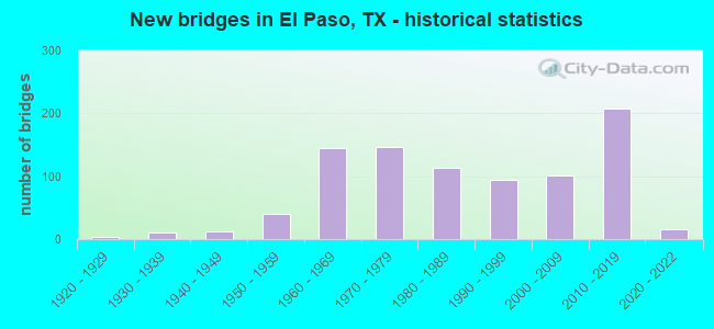
- New bridges - historical statistics
- 11910-1919
- 41920-1929
- 101930-1939
- 121940-1949
- 401950-1959
- 1441960-1969
- 1461970-1979
- 1131980-1989
- 941990-1999
- 1012000-2009
- 2072010-2019
- 162020-2022
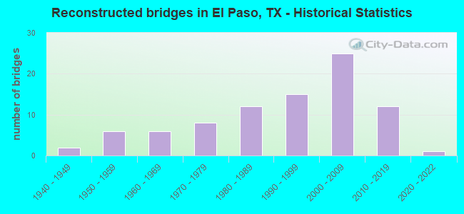
- Reconstructed bridges - Historical Statistics
- 21940-1949
- 61950-1959
- 61960-1969
- 81970-1979
- 121980-1989
- 151990-1999
- 252000-2009
- 122010-2019
- 12020-2022
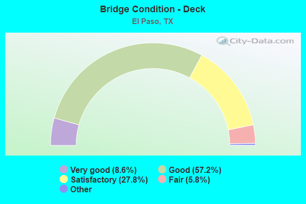
- Bridge Condition - Deck
- 8.6%Excellent
- 57.2%Very good
- 27.8%Good
- 5.8%Satisfactory
- 0.6%Fair
- 0.2%Poor
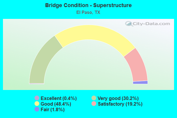
- Bridge Condition - Superstructure
- 0.4%Excellent
- 30.2%Very good
- 48.4%Good
- 19.2%Satisfactory
- 1.8%Fair
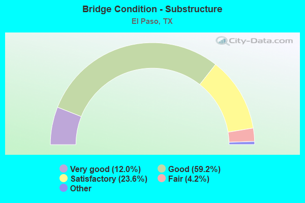
- Bridge Condition - Substructure
- 12.0%Excellent
- 59.2%Very good
- 23.6%Good
- 4.2%Satisfactory
- 1.0%Fair
- 0.6%Poor
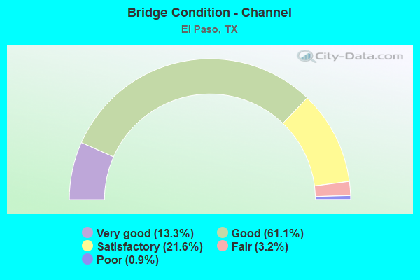
- Bridge Condition - Channel
- 13.3%Very good
- 61.1%Good
- 21.6%Satisfactory
- 3.2%Fair
- 0.9%Poor
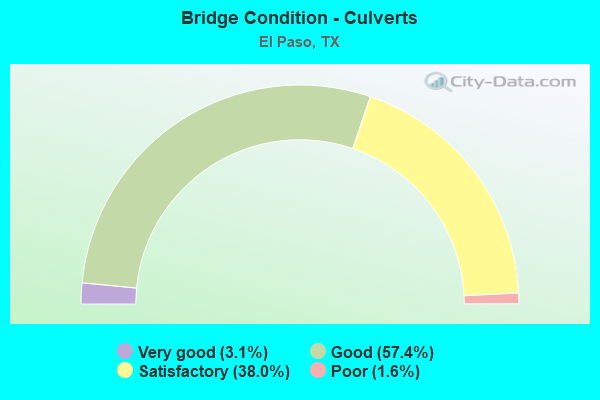
- Bridge Condition - Culverts
- 3.1%Very good
- 57.4%Good
- 38.0%Satisfactory
- 1.6%Poor
Find on map >> Show street view
Structure Number: 240720B68640004, Location: 0.10 MI E OF PERSHING DR (Lat: 31.788669, Lng: -106.446475), Route carried "on" structure: City street 48, Year Built: 1974, Status: Open, Structure Length: 0.85m (2.79ft), Average Daily Traffic: 8,450 (year 2015), Average Future Daily Traffic: 10,000 (year 2035), Design Load: H 20, Features Intersected: GOVT. HILLS DRAIN, Facility Carried by Structure: TROWBRIDGE DR
Minimum Vertical Clearance: 30+ m (98+ ft), Kilometerpoint: 0.161, Lanes on structure: 4, Owner: City or Municipal Highway Agency, Approaching Roadway Width: 18.3m (60.0ft), Material/Design: Concrete, Design/Construction: Culvert, Number Of Spans In Main Unit: 5, Length of Maximum Span: 1.5m (4.9ft), Curb or Sidewalk Widths: Left: 1.4m (4.6ft), Right: 1.3m (4.3ft), Curb-To-Curb Width: 18.3m (60.0ft), Out-to-Out Width: 21.7m (71.2ft)
Condition: Channel: Good, Culverts: Satisfactory, Operating Rating: 39.9 metric tons, Method Used To Determine Operating Rating: Load Factor (LF), Inventory Rating: 23.6 metric tons, Method Used To Determine Inventory Rating: Load Factor (LF), Structural Evaluation: Somewhat better than minimum adequacy, Deck Geometry: Somewhat better than minimum adequacy, Waterway Adequacy: Equal to present minimum criteria, Approach Roadway Alignment: Equal to present desirable criteria, Designated Inspection Frequency: Every 24 months, Inspection Date: May 2020, Deck Structure Type: Concrete Cast-file-Place
Find on map >> Show street view
Structure Number: 240720B69000001, Location: 0.05 MI S OF RIVERBEND (Lat: 31.826839, Lng: -106.580408), Route carried "on" structure: City street , Year Built: 1984, Status: Open, Structure Length: 1.83m (6.00ft), Average Daily Traffic: 8,100 (year 2018), Truck Traffic: 3%, Average Future Daily Traffic: 1,810 (year 2038), Design Load: HS 20, Features Intersected: MONTOYA DRAINAGE DITCH, Facility Carried by Structure: TURNSTONE DR
Minimum Vertical Clearance: 30+ m (98+ ft), Kilometerpoint: 0.402, Lanes on structure: 2, Owner: City or Municipal Highway Agency, Approaching Roadway Width: 14.0m (45.9ft), Material/Design: Prestressed concrete, Number Of Spans In Main Unit: 1, Length of Maximum Span: 18.3m (60.0ft), Curb or Sidewalk Widths: Left: 1.7m (5.6ft), Right: 0.0m, Curb-To-Curb Width: 14.1m (46.3ft), Out-to-Out Width: 16.5m (54.1ft)
Condition: Deck: Very good, Superstructure: Good, Substructure: Good, Channel: Satisfactory, Operating Rating: 54.4 metric tons, Method Used To Determine Operating Rating: Assigned rating based on Load Factor Design (LFD) reported in metric tons, Inventory Rating: 32.7 metric tons, Method Used To Determine Inventory Rating: Assigned rating based on Load Factor Design (LFD) reported in metric tons, Structural Evaluation: Better than present minimum criteria, Deck Geometry: Superior to present desirable criteria, Waterway Adequacy: Better than present minimum criteria, Approach Roadway Alignment: Equal to present desirable criteria, Length Of Structure Improvement: 1.83m (6.00ft), Designated Inspection Frequency: Every 24 months, Inspection Date: May 2020, Bridge Improvement Cost: $6,000, Roadway Improvement Cost: $2,000, Total Project Cost: $8,000, Deck Structure Type: Concrete Precast Panels, Wearing Surface/Protective System: Wearing Surface: Bituminous
Find on map >> Show street view
Structure Number: 240720B69240001, Location: 0.15 MI N OF FM 76 (Lat: 31.723075, Lng: -106.332986), Route carried "on" structure: City street , Year Built: 1990, Status: Open, Structure Length: 0.76m (2.49ft), Average Daily Traffic: 50 (year 2017), Average Future Daily Traffic: 300 (year 2037), Design Load: HS 20, Features Intersected: JUAN DE HERRERA LAT A, Facility Carried by Structure: UPLAND ST
Minimum Vertical Clearance: 30+ m (98+ ft), Kilometerpoint: 0.113, Lanes on structure: 2, Owner: City or Municipal Highway Agency, Approaching Roadway Width: 6.1m (20.0ft), Material/Design: Concrete, Design/Construction: Slab, Number Of Spans In Main Unit: 1, Length of Maximum Span: 7.6m (24.9ft), Curb or Sidewalk Widths: Left: 0.0m, Right: 1.1m (3.6ft), Curb-To-Curb Width: 7.2m (23.6ft), Out-to-Out Width: 9.1m (29.9ft)
Condition: Deck: Good, Superstructure: Good, Substructure: Very good, Channel: Very good, Operating Rating: 54.4 metric tons, Method Used To Determine Operating Rating: Assigned rating based on Load Factor Design (LFD) reported in metric tons, Inventory Rating: 32.7 metric tons, Method Used To Determine Inventory Rating: Assigned rating based on Load Factor Design (LFD) reported in metric tons, Structural Evaluation: Better than present minimum criteria, Deck Geometry: Somewhat better than minimum adequacy, Waterway Adequacy: Better than present minimum criteria, Approach Roadway Alignment: Better than present minimum criteria, Designated Inspection Frequency: Every 24 months, Inspection Date: April 2020, Deck Structure Type: Concrete Cast-file-Place
Find on map >> Show street view
Structure Number: 240720B69240002, Location: 0.01 MI N OF FM 76 (Lat: 31.721769, Lng: -106.333878), Route carried "on" structure: City street , Year Built: 1970, Status: Posted for load, Structure Length: 1.37m (4.49ft), Average Daily Traffic: 220 (year 2017), Truck Traffic: 1%, Average Future Daily Traffic: 851 (year 2037), Features Intersected: MESA DRAIN, Facility Carried by Structure: UPLAND ST
Minimum Vertical Clearance: 30+ m (98+ ft), Kilometerpoint: 0.274, Lanes on structure: 2, Owner: City or Municipal Highway Agency, Approaching Roadway Width: 11.0m (36.1ft), Material/Design: Prestressed concrete, Number Of Spans In Main Unit: 1, Length of Maximum Span: 13.1m (43.0ft), Curb or Sidewalk Widths: Left: 1.6m (5.2ft), Right: 1.6m (5.2ft), Curb-To-Curb Width: 11.0m (36.1ft), Out-to-Out Width: 14.7m (48.2ft)
Condition: Deck: Satisfactory, Superstructure: Good, Substructure: Good, Channel: Good, Operating Rating: 32.7 metric tons, Method Used To Determine Operating Rating: Field evaluation and documented engineering judgment, Inventory Rating: 24.5 metric tons, Method Used To Determine Inventory Rating: Field evaluation and documented engineering judgment, Structural Evaluation: Equal to present minimum criteria, Deck Geometry: Equal to present desirable criteria, Waterway Adequacy: Better than present minimum criteria, Approach Roadway Alignment: Equal to present desirable criteria, Designated Inspection Frequency: Every 24 months, Inspection Date: April 2020, Deck Structure Type: Concrete Cast-file-Place
Find on map >> Show street view
Structure Number: 240720B69440001, Location: AT INT VALDESPINO/ROSEWAY (Lat: 31.711497, Lng: -106.345706), Route carried "on" structure: City street , Year Built: 1990, Status: Open, Structure Length: 1.89m (6.20ft), Average Daily Traffic: 1,400 (year 2010), Truck Traffic: 2%, Average Future Daily Traffic: 1,800 (year 2030), Design Load: HS 20, Features Intersected: FRANKLIN CANAL, Facility Carried by Structure: VALDESPINO ST
Minimum Vertical Clearance: 30+ m (98+ ft), Kilometerpoint: 0.016, Lanes on structure: 2, Owner: City or Municipal Highway Agency, Approaching Roadway Width: 11.0m (36.1ft), Skew: 4 degrees, Material/Design: Prestressed concrete, Design/Construction: Box Beam or Girders - Multiple, Number Of Spans In Main Unit: 1, Length of Maximum Span: 18.9m (62.0ft), Curb or Sidewalk Widths: Left: 1.2m (3.9ft), Right: 1.2m (3.9ft), Curb-To-Curb Width: 8.5m (27.9ft), Out-to-Out Width: 11.6m (38.1ft)
Condition: Deck: Very good, Superstructure: Very good, Substructure: Good, Channel: Satisfactory, Operating Rating: 54.4 metric tons, Method Used To Determine Operating Rating: Assigned rating based on Load Factor Design (LFD) reported in metric tons, Inventory Rating: 32.7 metric tons, Method Used To Determine Inventory Rating: Assigned rating based on Load Factor Design (LFD) reported in metric tons, Structural Evaluation: Better than present minimum criteria, Deck Geometry: Somewhat better than minimum adequacy, Waterway Adequacy: Better than present minimum criteria, Approach Roadway Alignment: Somewhat better than minimum adequacy, Length Of Structure Improvement: 1.89m (6.20ft), Designated Inspection Frequency: Every 24 months, Inspection Date: May 2020, Deck Structure Type: Other, Wearing Surface/Protective System: Wearing Surface: Bituminous
Find on map >> Show street view
Structure Number: 240720B69520001, Location: 0.01 MI S OF EL PASO DR (Lat: 31.768594, Lng: -106.408019), Route carried "on" structure: City street , Year Built: 1974, Status: Open, Structure Length: 1.10m (3.61ft), Average Daily Traffic: 840 (year 2010), Truck Traffic: 1%, Average Future Daily Traffic: 1,351 (year 2030), Design Load: HS 20, Features Intersected: FRANKLIN CANAL, Facility Carried by Structure: VALENCIA PL
Minimum Vertical Clearance: 30+ m (98+ ft), Kilometerpoint: 0.016, Lanes on structure: 2, Owner: City or Municipal Highway Agency, Approaching Roadway Width: 7.3m (24.0ft), Material/Design: Prestressed concrete, Number Of Spans In Main Unit: 1, Length of Maximum Span: 11.0m (36.1ft), Curb or Sidewalk Widths: Left: 0.0m, Right: 1.5m (4.9ft), Curb-To-Curb Width: 7.3m (24.0ft), Out-to-Out Width: 9.4m (30.8ft)
Condition: Deck: Satisfactory, Superstructure: Good, Substructure: Good, Channel: Good, Operating Rating: 44.4 metric tons, Method Used To Determine Operating Rating: Assigned ratings based on Allowable Stress Design (ASD) reported in metric tons, Inventory Rating: 32.7 metric tons, Method Used To Determine Inventory Rating: Assigned ratings based on Allowable Stress Design (ASD) reported in metric tons, Structural Evaluation: Better than present minimum criteria, Deck Geometry: Meets minimum limits, Waterway Adequacy: Better than present minimum criteria, Approach Roadway Alignment: Equal to present minimum criteria, Length Of Structure Improvement: 1.10m (3.61ft), Designated Inspection Frequency: Every 24 months, Inspection Date: May 2020, Total Project Cost: $20,000, Deck Structure Type: Concrete Precast Panels
Find on map >> Show street view
Structure Number: 240720B69580001, Location: 0.10 MI S OF SH 20 (Lat: 31.768553, Lng: -106.432858), Route carried "on" structure: City street , Year Built: 1950, Status: Open, Structure Length: 0.67m (2.20ft), Average Daily Traffic: 9,190 (year 2015), Truck Traffic: 6%, Average Future Daily Traffic: 14,760 (year 2035), Design Load: H 20, Features Intersected: FRANKLIN CANAL, Facility Carried by Structure: VAL VERDE ST.
Minimum Vertical Clearance: 30+ m (98+ ft), Kilometerpoint: 0.177, Lanes on structure: 5, Owner: City or Municipal Highway Agency, Approaching Roadway Width: 15.5m (50.9ft), Material/Design: Concrete, Design/Construction: Culvert, Number Of Spans In Main Unit: 2, Length of Maximum Span: 3.0m (9.8ft), Curb or Sidewalk Widths: Left: 1.8m (5.9ft), Right: 1.4m (4.6ft), Curb-To-Curb Width: 15.5m (50.9ft), Out-to-Out Width: 19.3m (63.3ft)
Condition: Channel: Satisfactory, Culverts: Satisfactory, Operating Rating: 32.7 metric tons, Method Used To Determine Operating Rating: Field evaluation and documented engineering judgment, Inventory Rating: 24.5 metric tons, Method Used To Determine Inventory Rating: Field evaluation and documented engineering judgment, Structural Evaluation: Equal to present minimum criteria, Deck Geometry: High priority of replacement, Waterway Adequacy: Equal to present minimum criteria, Approach Roadway Alignment: Equal to present desirable criteria, Length Of Structure Improvement: 0.67m (2.20ft), Designated Inspection Frequency: Every 24 months, Inspection Date: May 2020, Bridge Improvement Cost: $2,000, Roadway Improvement Cost: $1,000, Total Project Cost: $3,000, Deck Structure Type: Concrete Cast-file-Place, Wearing Surface/Protective System: Wearing Surface: Bituminous
Find on map >> Show street view
Structure Number: 240720B69691001, Location: 0.15 MI N OF VAN HORN ST (Lat: 31.923006, Lng: -106.418333), Route carried "on" structure: City street , Year Built: 1977, Status: Posted for load, Structure Length: 1.83m (6.00ft), Average Daily Traffic: 530 (year 2017), Truck Traffic: 3%, Average Future Daily Traffic: 851 (year 2037), Features Intersected: DRAINAGE CHANNEL NO 1, Facility Carried by Structure: WADSWORTH AVE
Minimum Vertical Clearance: 30+ m (98+ ft), Kilometerpoint: 0.032, Lanes on structure: 2, Owner: City or Municipal Highway Agency, Approaching Roadway Width: 11.0m (36.1ft), Material/Design: Prestressed concrete, Number Of Spans In Main Unit: 2, Length of Maximum Span: 9.1m (29.9ft), Curb or Sidewalk Widths: Left: 0.0m, Right: 1.7m (5.6ft), Curb-To-Curb Width: 11.2m (36.7ft), Out-to-Out Width: 13.4m (44.0ft)
Condition: Deck: Satisfactory, Superstructure: Satisfactory, Substructure: Satisfactory, Channel: Good, Operating Rating: 32.7 metric tons, Method Used To Determine Operating Rating: Field evaluation and documented engineering judgment, Inventory Rating: 24.5 metric tons, Method Used To Determine Inventory Rating: Field evaluation and documented engineering judgment, Structural Evaluation: Equal to present minimum criteria, Deck Geometry: Better than present minimum criteria, Waterway Adequacy: Better than present minimum criteria, Approach Roadway Alignment: Equal to present desirable criteria, Designated Inspection Frequency: Every 24 months, Inspection Date: April 2020, Deck Structure Type: Concrete Precast Panels, Wearing Surface/Protective System: Wearing Surface: Bituminous
Find on map >> Show street view
Structure Number: 240720B70840001, Location: 0.28 MI N OF RAILROAD DR (Lat: 31.850214, Lng: -106.422656), Route carried "on" structure: City street , Year Built: 1989, Status: Open, Structure Length: 1.68m (5.51ft), Average Daily Traffic: 1,060 (year 2017), Truck Traffic: 3%, Average Future Daily Traffic: 2,700 (year 2037), Design Load: HS 20, Features Intersected: DIANA DRAINAGE DITCH, Facility Carried by Structure: VULCAN AVE
Minimum Vertical Clearance: 30+ m (98+ ft), Kilometerpoint: 1.609, Lanes on structure: 2, Owner: City or Municipal Highway Agency, Approaching Roadway Width: 11.0m (36.1ft), Material/Design: Concrete, Design/Construction: Culvert, Number Of Spans In Main Unit: 5, Length of Maximum Span: 3.0m (9.8ft), Curb or Sidewalk Widths: Left: 1.2m (3.9ft), Right: 1.2m (3.9ft), Curb-To-Curb Width: 11.0m (36.1ft), Out-to-Out Width: 18.4m (60.4ft)
Condition: Channel: Good, Culverts: Satisfactory, Operating Rating: 39.9 metric tons, Method Used To Determine Operating Rating: Load Factor (LF), Inventory Rating: 23.6 metric tons, Method Used To Determine Inventory Rating: Load Factor (LF), Structural Evaluation: Equal to present minimum criteria, Deck Geometry: Equal to present minimum criteria, Waterway Adequacy: Better than present minimum criteria, Approach Roadway Alignment: Equal to present desirable criteria, Designated Inspection Frequency: Every 24 months, Inspection Date: April 2020, Deck Structure Type: Concrete Cast-file-Place, Wearing Surface/Protective System: Wearing Surface: Monolithic Concrete
Find on map >> Show street view
Structure Number: 240720B71521001, Location: 0.30 MI NE OF FM 76 (Lat: 31.701983, Lng: -106.309719), Route carried "on" structure: City street , Year Built: 1977, Status: Posted for load, Structure Length: 1.46m (4.79ft), Average Daily Traffic: 2,990 (year 2010), Truck Traffic: 1%, Average Future Daily Traffic: 3,289 (year 2030), Design Load: H 20, Features Intersected: MESA DRAIN, Facility Carried by Structure: WARWICK RD
Minimum Vertical Clearance: 30+ m (98+ ft), Kilometerpoint: 0.563, Lanes on structure: 2, Owner: City or Municipal Highway Agency, Approaching Roadway Width: 13.4m (44.0ft), Material/Design: Prestressed concrete, Number Of Spans In Main Unit: 1, Length of Maximum Span: 14.6m (47.9ft), Curb or Sidewalk Widths: Left: 1.5m (4.9ft), Right: 1.5m (4.9ft), Curb-To-Curb Width: 13.4m (44.0ft), Out-to-Out Width: 17.1m (56.1ft)
Condition: Deck: Satisfactory, Superstructure: Good, Substructure: Good, Channel: Good, Operating Rating: 32.7 metric tons, Method Used To Determine Operating Rating: Field evaluation and documented engineering judgment, Inventory Rating: 24.5 metric tons, Method Used To Determine Inventory Rating: Field evaluation and documented engineering judgment, Structural Evaluation: Equal to present minimum criteria, Deck Geometry: Better than present minimum criteria, Waterway Adequacy: Better than present minimum criteria, Approach Roadway Alignment: Equal to present desirable criteria, Designated Inspection Frequency: Every 24 months, Inspection Date: April 2020, Deck Structure Type: Concrete Cast-file-Place
Find on map >> Show street view
Structure Number: 240720B71560001, Location: 0.01 MI N OF US 62 (Lat: 31.767858, Lng: -106.440650), Route carried "on" structure: City street , Year Built: 1975, Status: Open, Structure Length: 1.10m (3.61ft), Average Daily Traffic: 2,251 (year 2015), Average Future Daily Traffic: 2,651 (year 2035), Design Load: HS 20, Features Intersected: FRANKLIN CANAL, Facility Carried by Structure: WASHINGTON ST
Minimum Vertical Clearance: 30+ m (98+ ft), Kilometerpoint: 0.483, Lanes on structure: 2, Owner: City or Municipal Highway Agency, Approaching Roadway Width: 11.3m (37.1ft), Material/Design: Prestressed concrete, Number Of Spans In Main Unit: 1, Length of Maximum Span: 11.0m (36.1ft), Curb or Sidewalk Widths: Left: 0.0m, Right: 1.5m (4.9ft), Curb-To-Curb Width: 11.0m (36.1ft), Out-to-Out Width: 13.1m (43.0ft)
Condition: Deck: Satisfactory, Superstructure: Good, Substructure: Good, Channel: Good, Operating Rating: 44.4 metric tons, Method Used To Determine Operating Rating: Assigned ratings based on Allowable Stress Design (ASD) reported in metric tons, Inventory Rating: 32.7 metric tons, Method Used To Determine Inventory Rating: Assigned ratings based on Allowable Stress Design (ASD) reported in metric tons, Structural Evaluation: Better than present minimum criteria, Deck Geometry: Somewhat better than minimum adequacy, Waterway Adequacy: Better than present minimum criteria, Approach Roadway Alignment: Equal to present desirable criteria, Designated Inspection Frequency: Every 24 months, Inspection Date: May 2020, Deck Structure Type: Concrete Precast Panels
Find on map >> Show street view
Structure Number: 240720B72240001, Location: 0.15 MI NE OF FM 76 (Lat: 31.739664, Lng: -106.359250), Route carried "on" structure: City street , Year Built: 1970, Status: Posted for load, Structure Length: 1.72m (5.64ft), Average Daily Traffic: 1,440 (year 2010), Truck Traffic: 2%, Average Future Daily Traffic: 2,380 (year 2030), Features Intersected: MESA DRAIN, Facility Carried by Structure: WEST DR
Minimum Vertical Clearance: 30+ m (98+ ft), Kilometerpoint: 0.241, Lanes on structure: 2, Owner: City or Municipal Highway Agency, Approaching Roadway Width: 9.1m (29.9ft), Skew: 4 degrees, Material/Design: Prestressed concrete, Number Of Spans In Main Unit: 1, Length of Maximum Span: 17.2m (56.4ft), Curb or Sidewalk Widths: Left: 1.5m (4.9ft), Right: 1.5m (4.9ft), Curb-To-Curb Width: 11.0m (36.1ft), Out-to-Out Width: 14.6m (47.9ft)
Condition: Deck: Satisfactory, Superstructure: Good, Substructure: Good, Channel: Good, Operating Rating: 32.7 metric tons, Method Used To Determine Operating Rating: Field evaluation and documented engineering judgment, Inventory Rating: 24.5 metric tons, Method Used To Determine Inventory Rating: Field evaluation and documented engineering judgment, Structural Evaluation: Equal to present minimum criteria, Deck Geometry: Equal to present minimum criteria, Waterway Adequacy: Better than present minimum criteria, Approach Roadway Alignment: Equal to present minimum criteria, Designated Inspection Frequency: Every 24 months, Inspection Date: May 2020, Deck Structure Type: Concrete Cast-file-Place
Find on map >> Show street view
Structure Number: 240720B72540001, Location: 0.50 MI W OF SH 20 (Lat: 31.706369, Lng: -106.353622), Route carried "on" structure: City street , Year Built: 1975, Status: Posted for load, Structure Length: 1.37m (4.49ft), Average Daily Traffic: 1,470 (year 2010), Truck Traffic: 2%, Average Future Daily Traffic: 1,851 (year 2030), Design Load: H 20, Features Intersected: PLAYA DRAIN, Facility Carried by Structure: WHITTIER DR
Minimum Vertical Clearance: 30+ m (98+ ft), Kilometerpoint: 0.805, Lanes on structure: 2, Owner: City or Municipal Highway Agency, Approaching Roadway Width: 13.4m (44.0ft), Material/Design: Prestressed concrete, Number Of Spans In Main Unit: 1, Length of Maximum Span: 13.7m (44.9ft), Curb or Sidewalk Widths: Left: 1.5m (4.9ft), Right: 1.5m (4.9ft), Curb-To-Curb Width: 13.4m (44.0ft), Out-to-Out Width: 17.1m (56.1ft)
Condition: Deck: Good, Superstructure: Good, Substructure: Good, Channel: Good, Operating Rating: 32.7 metric tons, Method Used To Determine Operating Rating: Field evaluation and documented engineering judgment, Inventory Rating: 24.5 metric tons, Method Used To Determine Inventory Rating: Field evaluation and documented engineering judgment, Structural Evaluation: Equal to present minimum criteria, Deck Geometry: Equal to present desirable criteria, Waterway Adequacy: Better than present minimum criteria, Approach Roadway Alignment: Equal to present desirable criteria, Designated Inspection Frequency: Every 24 months, Inspection Date: May 2020, Deck Structure Type: Concrete Cast-file-Place
Find on map >> Show street view
Structure Number: 240720B74070004, Location: 0.10 MI NE OF FM 76 (Lat: 31.729625, Lng: -106.346656), Route carried "on" structure: City street 32, Year Built: 1962, Year Reconstructed: 1997, Status: Posted for load, Structure Length: 3.35m (10.99ft), Average Daily Traffic: 18,230 (year 2017), Average Future Daily Traffic: 21,000 (year 2037), Features Intersected: MESA DRAIN, Facility Carried by Structure: YARBROUGH DR
Minimum Vertical Clearance: 30+ m (98+ ft), Kilometerpoint: 8.159, Lanes on structure: 4, Owner: City or Municipal Highway Agency, Approaching Roadway Width: 18.9m (62.0ft), Skew: 26 degrees, Material/Design: Prestressed concrete, Design/Construction: Box Beam or Girders - Multiple, Number Of Spans In Main Unit: 2, Length of Maximum Span: 16.8m (55.1ft), Curb or Sidewalk Widths: Left: 1.9m (6.2ft), Right: 1.9m (6.2ft), Curb-To-Curb Width: 19.0m (62.3ft), Out-to-Out Width: 30.5m (100.1ft)
Condition: Deck: Good, Superstructure: Fair, Substructure: Fair, Channel: Satisfactory, Operating Rating: 32.7 metric tons, Method Used To Determine Operating Rating: Field evaluation and documented engineering judgment, Inventory Rating: 24.5 metric tons, Method Used To Determine Inventory Rating: Field evaluation and documented engineering judgment, Structural Evaluation: Somewhat better than minimum adequacy, Deck Geometry: Equal to present minimum criteria, Waterway Adequacy: Equal to present minimum criteria, Approach Roadway Alignment: Equal to present desirable criteria, Designated Inspection Frequency: Every 24 months, Inspection Date: April 2020, Deck Structure Type: Concrete Precast Panels, Wearing Surface/Protective System: Wearing Surface: Bituminous
Find on map >> Show street view
Structure Number: 240720B74070006, Location: 0.10 MI NE OF SH 20 (Lat: 31.722375, Lng: -106.351836), Route carried "on" structure: City street 32, Year Built: 2012, Status: Open, Structure Length: 6.71m (22.01ft), Average Daily Traffic: 11,980 (year 2010), Average Future Daily Traffic: 15,000 (year 2030), Design Load: HL 93, Features Intersected: UP RAILROAD, Facility Carried by Structure: YARBROUGH DR SB
Minimum Vertical Clearance: 30+ m (98+ ft), Kilometerpoint: 9.189, Lanes on structure: 2, Owner: City or Municipal Highway Agency, Approaching Roadway Width: 9.8m (32.2ft), Material/Design: Prestressed concrete, Design/Construction: Stringer/Multi-beam, Number Of Spans In Main Unit: 1, Number Of Approach Spans: 2, Length of Maximum Span: 36.6m (120.1ft), Curb or Sidewalk Widths: Left: 0.0m, Right: 1.5m (4.9ft), Curb-To-Curb Width: 9.5m (31.2ft), Out-to-Out Width: 12.0m (39.4ft)
Condition: Deck: Good, Superstructure: Very good, Substructure: Good, Operating Rating: 54.4 metric tons, Method Used To Determine Operating Rating: Assigned ratings based on Load and Resistance Factor Design (LRFD) reported in metric tons, Inventory Rating: 32.7 metric tons, Method Used To Determine Inventory Rating: Assigned ratings based on Load and Resistance Factor Design (LRFD) reported in metric tons, Structural Evaluation: Better than present minimum criteria, Deck Geometry: Meets minimum limits, Underclear: Better than present minimum criteria, Approach Roadway Alignment: Equal to present desirable criteria, Designated Inspection Frequency: Every 24 months, Inspection Date: May 2020, Deck Structure Type: Concrete Precast Panels
Find on map >> Show street view
Structure Number: 240720B74070007, Location: 0.10 MI NE OF SH 20 (Lat: 31.721719, Lng: -106.352039), Route carried "on" structure: City street 32, Year Built: 2012, Status: Open, Structure Length: 6.71m (22.01ft), Average Daily Traffic: 11,970 (year 2010), Average Future Daily Traffic: 15,000 (year 2030), Design Load: HL 93, Features Intersected: UP RAILROAD, Facility Carried by Structure: YARBROUGH DR NB
Minimum Vertical Clearance: 30+ m (98+ ft), Kilometerpoint: 9.205, Lanes on structure: 2, Owner: City or Municipal Highway Agency, Approaching Roadway Width: 9.8m (32.2ft), Material/Design: Prestressed concrete, Design/Construction: Stringer/Multi-beam, Number Of Spans In Main Unit: 1, Number Of Approach Spans: 2, Length of Maximum Span: 36.6m (120.1ft), Curb or Sidewalk Widths: Left: 1.6m (5.2ft), Right: 0.0m, Curb-To-Curb Width: 9.6m (31.5ft), Out-to-Out Width: 12.0m (39.4ft)
Condition: Deck: Good, Superstructure: Very good, Substructure: Very good, Operating Rating: 54.4 metric tons, Method Used To Determine Operating Rating: Assigned ratings based on Load and Resistance Factor Design (LRFD) reported in metric tons, Inventory Rating: 32.7 metric tons, Method Used To Determine Inventory Rating: Assigned ratings based on Load and Resistance Factor Design (LRFD) reported in metric tons, Structural Evaluation: Equal to present desirable criteria, Deck Geometry: Meets minimum limits, Underclear: Superior to present desirable criteria, Approach Roadway Alignment: Equal to present desirable criteria, Designated Inspection Frequency: Every 24 months, Inspection Date: May 2020, Deck Structure Type: Concrete Precast Panels
Find on map >> Show street view
Structure Number: 240720B74070012, Location: 0.15 MI SW OF SH 20 (Lat: 31.719553, Lng: -106.355556), Route carried "on" structure: City street 32, Year Built: 1980, Status: Open, Structure Length: 1.40m (4.59ft), Average Daily Traffic: 14,070 (year 2010), Average Future Daily Traffic: 14,450 (year 2030), Design Load: HS 20, Features Intersected: FRANKLIN CANAL, Facility Carried by Structure: YARBROUGH DR
Minimum Vertical Clearance: 30+ m (98+ ft), Kilometerpoint: 0.241, Lanes on structure: 7, Owner: City or Municipal Highway Agency, Approaching Roadway Width: 26.8m (87.9ft), Skew: 21 degrees, Material/Design: Prestressed concrete, Design/Construction: Box Beam or Girders - Multiple, Number Of Spans In Main Unit: 1, Length of Maximum Span: 14.0m (45.9ft), Curb or Sidewalk Widths: Left: 1.8m (5.9ft), Right: 1.5m (4.9ft), Curb-To-Curb Width: 26.8m (87.9ft), Out-to-Out Width: 33.4m (109.6ft)
Condition: Deck: Very good, Superstructure: Very good, Substructure: Good, Channel: Good, Operating Rating: 54.4 metric tons, Method Used To Determine Operating Rating: Assigned rating based on Load Factor Design (LFD) reported in metric tons, Inventory Rating: 32.7 metric tons, Method Used To Determine Inventory Rating: Assigned rating based on Load Factor Design (LFD) reported in metric tons, Structural Evaluation: Better than present minimum criteria, Deck Geometry: Somewhat better than minimum adequacy, Waterway Adequacy: Equal to present minimum criteria, Approach Roadway Alignment: Equal to present desirable criteria, Designated Inspection Frequency: Every 24 months, Inspection Date: May 2020, Deck Structure Type: Other, Wearing Surface/Protective System: Wearing Surface: Bituminous
Find on map >> Show street view
Structure Number: 240720B74640001, Location: 1.5 MI S JCT SH 20 (Lat: 31.671053, Lng: -106.336914), Route carried "on" structure: City street , Year Built: 1990, Status: Open, Structure Length: 24.51m (80.41ft), Average Daily Traffic: 10,500 (year 2010), Average Future Daily Traffic: 10,550 (year 2030), Features Intersected: RIO GRANDE RIVER, Facility Carried by Structure: ZARAGOSA INTL TRK
Minimum Vertical Clearance: 30+ m (98+ ft), Kilometerpoint: 2.499, Lanes on structure: 4, Toll: Toll bridge, Owner: City or Municipal Highway Agency, Approaching Roadway Width: 15.9m (52.2ft), Skew: 1 degrees, Material/Design: Prestressed concrete, Design/Construction: Stringer/Multi-beam, Number Of Spans In Main Unit: 8, Number Of Approach Spans: 1, Length of Maximum Span: 28.3m (92.8ft), Curb-To-Curb Width: 17.4m (57.1ft), Out-to-Out Width: 18.3m (60.0ft)
Condition: Deck: Satisfactory, Superstructure: Good, Substructure: Good, Channel: Good, Operating Rating: 68.0 metric tons, Method Used To Determine Operating Rating: Load Factor (LF), Inventory Rating: 40.8 metric tons, Method Used To Determine Inventory Rating: Load Factor (LF), Structural Evaluation: Better than present minimum criteria, Deck Geometry: Somewhat better than minimum adequacy, Waterway Adequacy: Equal to present desirable criteria, Approach Roadway Alignment: Equal to present desirable criteria, Length Of Structure Improvement: 24.51m (80.41ft), Designated Inspection Frequency: Every 24 months, Inspection Date: December 2020, Deck Structure Type: Concrete Cast-file-Place
Find on map >> Show street view
Structure Number: 240720B74640002, Location: 1.5 MI S JCT SH 20 (Lat: 31.671308, Lng: -106.337081), Route carried "on" structure: City street , Year Built: 1990, Status: Open, Structure Length: 24.51m (80.41ft), Average Daily Traffic: 10,500 (year 2010), Average Future Daily Traffic: 10,550 (year 2030), Features Intersected: RIO GRANDE RIVER, Facility Carried by Structure: ZARAGOSA INTL CARS
Minimum Vertical Clearance: 30+ m (98+ ft), Kilometerpoint: 2.499, Lanes on structure: 4, Toll: Toll bridge, Owner: City or Municipal Highway Agency, Approaching Roadway Width: 15.9m (52.2ft), Skew: 1 degrees, Material/Design: Prestressed concrete, Design/Construction: Stringer/Multi-beam, Number Of Spans In Main Unit: 8, Number Of Approach Spans: 1, Length of Maximum Span: 28.3m (92.8ft), Curb or Sidewalk Widths: Left: 3.0m (9.8ft), Right: 3.0m (9.8ft), Curb-To-Curb Width: 15.9m (52.2ft), Out-to-Out Width: 22.6m (74.1ft)
Condition: Deck: Satisfactory, Superstructure: Good, Substructure: Good, Channel: Good, Operating Rating: 68.0 metric tons, Method Used To Determine Operating Rating: Load Factor (LF), Inventory Rating: 40.8 metric tons, Method Used To Determine Inventory Rating: Load Factor (LF), Structural Evaluation: Better than present minimum criteria, Deck Geometry: Meets minimum limits, Waterway Adequacy: Equal to present desirable criteria, Approach Roadway Alignment: Equal to present desirable criteria, Length Of Structure Improvement: 24.51m (80.41ft), Designated Inspection Frequency: Every 24 months, Inspection Date: December 2020, Deck Structure Type: Concrete Cast-file-Place
Find on map >> Show street view
Structure Number: 240720B74640003, Location: 0.3 MI N OF SH 20 (Lat: 31.696383, Lng: -106.327506), Route carried "on" structure: City street 35, Year Built: 1977, Status: Open, Structure Length: 1.01m (3.31ft), Average Daily Traffic: 28,890 (year 2010), Average Future Daily Traffic: 35,000 (year 2030), Design Load: HS 20, Features Intersected: FRANKLIN CANAL, Facility Carried by Structure: ZARAGOSA RD
Minimum Vertical Clearance: 30+ m (98+ ft), Kilometerpoint: 1.336, Lanes on structure: 4, Owner: City or Municipal Highway Agency, Approaching Roadway Width: 14.6m (47.9ft), Skew: 2 degrees, Material/Design: Concrete, Design/Construction: Slab, Number Of Spans In Main Unit: 1, Length of Maximum Span: 10.1m (33.1ft), Curb or Sidewalk Widths: Left: 1.8m (5.9ft), Right: 1.8m (5.9ft), Curb-To-Curb Width: 14.6m (47.9ft), Out-to-Out Width: 18.9m (62.0ft)
Condition: Deck: Satisfactory, Superstructure: Satisfactory, Substructure: Good, Channel: Very good, Operating Rating: 54.4 metric tons, Method Used To Determine Operating Rating: Assigned rating based on Load Factor Design (LFD) reported in metric tons, Inventory Rating: 32.7 metric tons, Method Used To Determine Inventory Rating: Assigned rating based on Load Factor Design (LFD) reported in metric tons, Structural Evaluation: Equal to present minimum criteria, Deck Geometry: High priority of replacement, Waterway Adequacy: Equal to present minimum criteria, Approach Roadway Alignment: Equal to present desirable criteria, Length Of Structure Improvement: 1.01m (3.31ft), Designated Inspection Frequency: Every 24 months, Inspection Date: May 2020, Bridge Improvement Cost: $3,000, Roadway Improvement Cost: $1,000, Total Project Cost: $4,000, Deck Structure Type: Concrete Cast-file-Place
Find on map >> Show street view
Structure Number: 240720LH5078001, Location: .27 Mi. N. Of SH 178 (Lat: 31.886314, Lng: -106.585969), Route carried "on" structure: City street , Year Built: 2011, Status: Open, Structure Length: 0.88m (2.89ft), Average Daily Traffic: 2,895 (year 2017), Average Future Daily Traffic: 2,895 (year 2017), Design Load: HL 93, Features Intersected: DRAIN, Facility Carried by Structure: BERRINGER STREET
Minimum Vertical Clearance: 30+ m (98+ ft), Kilometerpoint: 0.435, Lanes on structure: 2, Owner: City or Municipal Highway Agency, Approaching Roadway Width: 11.0m (36.1ft), Skew: 1 degrees, Material/Design: Concrete, Design/Construction: Culvert, Number Of Spans In Main Unit: 2, Length of Maximum Span: 4.0m (13.1ft), Curb or Sidewalk Widths: Left: 1.2m (3.9ft), Right: 1.2m (3.9ft)
Condition: Channel: Very good, Culverts: Good, Operating Rating: 54.4 metric tons, Method Used To Determine Operating Rating: Assigned ratings based on Load and Resistance Factor Design (LRFD) reported in metric tons, Inventory Rating: 32.7 metric tons, Method Used To Determine Inventory Rating: Assigned ratings based on Load and Resistance Factor Design (LRFD) reported in metric tons, Structural Evaluation: Better than present minimum criteria, Waterway Adequacy: Equal to present desirable criteria, Approach Roadway Alignment: Better than present minimum criteria, Designated Inspection Frequency: Every 24 months, Inspection Date: October 2020
Find on map >> Show street view
Structure Number: 240720LH5078002, Location: .5 Mi. N. OF SH 178 (Lat: 31.890681, Lng: -106.586294), Route carried "on" structure: City street , Year Built: 2011, Status: Open, Structure Length: 0.88m (2.89ft), Average Daily Traffic: 2,895 (year 2017), Average Future Daily Traffic: 2,995 (year 2037), Design Load: HL 93, Features Intersected: DRAIN, Facility Carried by Structure: BERRINGER STREET
Minimum Vertical Clearance: 30+ m (98+ ft), Kilometerpoint: 0.805, Lanes on structure: 2, Owner: City or Municipal Highway Agency, Approaching Roadway Width: 9.8m (32.2ft), Skew: 1 degrees, Material/Design: Concrete, Design/Construction: Culvert, Number Of Spans In Main Unit: 2, Length of Maximum Span: 4.0m (13.1ft), Curb or Sidewalk Widths: Left: 1.5m (4.9ft), Right: 1.5m (4.9ft), Curb-To-Curb Width: 9.8m (32.2ft), Out-to-Out Width: 17.2m (56.4ft)
Condition: Channel: Very good, Culverts: Good, Operating Rating: 54.4 metric tons, Method Used To Determine Operating Rating: Assigned ratings based on Load and Resistance Factor Design (LRFD) reported in metric tons, Inventory Rating: 32.7 metric tons, Method Used To Determine Inventory Rating: Assigned ratings based on Load and Resistance Factor Design (LRFD) reported in metric tons, Structural Evaluation: Better than present minimum criteria, Deck Geometry: Meets minimum limits, Waterway Adequacy: Equal to present desirable criteria, Approach Roadway Alignment: Equal to present desirable criteria, Designated Inspection Frequency: Every 24 months, Inspection Date: October 2020, Deck Structure Type: Concrete Cast-file-Place
Find on map >> Show street view
Structure Number: 240720LH9000001, Location: 100 FT. W. OF MONTECILLO (Lat: 31.808433, Lng: -106.514967), Route carried "on" structure: City street , Year Built: 2018, Status: Open, Structure Length: 1.92m (6.30ft), Average Daily Traffic: 50 (year 2018), Average Future Daily Traffic: 100 (year 2038), Design Load: HL 93, Features Intersected: DRAIN, Facility Carried by Structure: CASTELLANO DR.
Minimum Vertical Clearance: 30+ m (98+ ft), Kilometerpoint: 1.609, Lanes on structure: 2, Owner: City or Municipal Highway Agency, Approaching Roadway Width: 8.7m (28.5ft), Material/Design: Prestressed concrete, Design/Construction: Stringer/Multi-beam, Number Of Spans In Main Unit: 1, Length of Maximum Span: 19.2m (63.0ft), Curb or Sidewalk Widths: Left: 1.8m (5.9ft), Right: 1.8m (5.9ft), Curb-To-Curb Width: 8.5m (27.9ft), Out-to-Out Width: 12.8m (42.0ft)
Condition: Deck: Very good, Superstructure: Satisfactory, Substructure: Good, Channel: Good, Operating Rating: 54.4 metric tons, Method Used To Determine Operating Rating: Assigned ratings based on Load and Resistance Factor Design (LRFD) reported in metric tons, Inventory Rating: 32.7 metric tons, Method Used To Determine Inventory Rating: Assigned ratings based on Load and Resistance Factor Design (LRFD) reported in metric tons, Structural Evaluation: Equal to present minimum criteria, Deck Geometry: Better than present minimum criteria, Waterway Adequacy: Better than present minimum criteria, Approach Roadway Alignment: Equal to present desirable criteria, Designated Inspection Frequency: Every 24 months, Inspection Date: May 2020, Deck Structure Type: Concrete Cast-file-Place
Find on map >> Show street view
Structure Number: 240720LZ5625001, Location: 0.10 MI N OF LP 375 WBFR (Lat: 31.909478, Lng: -106.572586), Route carried "on" structure: City street , Year Built: 2015, Status: Open, Structure Length: 1.59m (5.22ft), Average Daily Traffic: 50 (year 2017), Average Future Daily Traffic: 100 (year 2037), Design Load: H 20, Features Intersected: DRAW, Facility Carried by Structure: BLUFF CREEK ST
Minimum Vertical Clearance: 30+ m (98+ ft), Kilometerpoint: 0.161, Lanes on structure: 2, Owner: City or Municipal Highway Agency, Approaching Roadway Width: 12.8m (42.0ft), Material/Design: Concrete, Design/Construction: Culvert, Number Of Spans In Main Unit: 6, Length of Maximum Span: 2.4m (7.9ft), Curb or Sidewalk Widths: Left: 1.5m (4.9ft), Right: 1.5m (4.9ft), Curb-To-Curb Width: 13.4m (44.0ft), Out-to-Out Width: 32.6m (107.0ft)
Condition: Channel: Good, Culverts: Good, Operating Rating: 32.7 metric tons, Method Used To Determine Operating Rating: No rating analysis performed, Inventory Rating: 24.5 metric tons, Method Used To Determine Inventory Rating: No rating analysis performed, Structural Evaluation: Equal to present minimum criteria, Deck Geometry: Superior to present desirable criteria, Waterway Adequacy: Better than present minimum criteria, Approach Roadway Alignment: Equal to present desirable criteria, Designated Inspection Frequency: Every 24 months, Inspection Date: May 2020, Deck Structure Type: Concrete Cast-file-Place, Wearing Surface/Protective System: Wearing Surface: Bituminous
Find on map >> Show street view
Structure Number: 222400008614193, Location: 0.80 MI S OF US 59 (Lat: 27.516700, Lng: -99.448731), Route carried "under" structure: State highway 400, Year Built: 2017, Structure Length: 0. m, Average Daily Traffic: 5,000 (year 2019), Truck Traffic: 5%, Features Intersected: SP 400, Facility Carried by Structure: LP 20 ML
Minimum Vertical Clearance: 5.56m (18.24ft), Kilometerpoint: 0.016, Lanes on structure: 4, Lanes under structure: 4, Material/Design: Prestressed concrete, Design/Construction: Stringer/Multi-beam, Length of Maximum Span: 40.5m (132.9ft)
Find on map >> Show street view
Structure Number: 222400008614197, Location: 2.3 MI W OF IH 35 (Lat: 27.613181, Lng: -99.466169), Route carried "under" structure: State highway , Year Built: 2017, Structure Length: 0. m, Average Daily Traffic: 8,660 (year 2013), Truck Traffic: 5%, Features Intersected: INTERNATIONAL BLVD, Facility Carried by Structure: LP 20 WBML
Minimum Vertical Clearance: 6.22m (20.41ft), Kilometerpoint: 6.309, Lanes on structure: 2, Lanes under structure: 6, Material/Design: Prestressed concrete, Design/Construction: Stringer/Multi-beam, Length of Maximum Span: 30.5m (100.1ft)
Find on map >> Show street view
Structure Number: 222400008614198, Location: 2.3 MI W OF IH 35 (Lat: 27.613181, Lng: -99.466169), Route carried "under" structure: City street , Year Built: 2017, Structure Length: 0. m, Average Daily Traffic: 8,000 (year 2019), Features Intersected: INTERNATIONAL BLVD, Facility Carried by Structure: LP 20 EBML
Minimum Vertical Clearance: 5.33m (17.49ft), Kilometerpoint: 6.244, Lanes on structure: 2, Lanes under structure: 6, Material/Design: Prestressed concrete, Design/Construction: Stringer/Multi-beam, Length of Maximum Span: 30.5m (100.1ft)
Find on map >> Show street view
Structure Number: 240720000101068, Location: 0.7 MI W OF IH 10 (Lat: 31.879100, Lng: -106.594325), Route carried "under" structure: State highway 20, Year Built: 2000, Structure Length: 0. m, Average Daily Traffic: 14,550 (year 2010), Truck Traffic: 7%, Features Intersected: SH 20 & BNSF RR, Facility Carried by Structure: SH 178 (ARTCRAFT)
Minimum Vertical Clearance: 7.06m (23.16ft), Kilometerpoint: 13.789, Lanes on structure: 6, Lanes under structure: 8, Material/Design: Prestressed concrete, Design/Construction: Stringer/Multi-beam, Length of Maximum Span: 36.6m (120.1ft)
Find on map >> Show street view
Structure Number: 240720000102228, Location: 0.75 MI SE OF US 85 (Lat: 31.795622, Lng: -106.531456), Route carried "under" structure: City street , Year Built: 2018, Structure Length: 0. m, Average Daily Traffic: 5,000 (year 2015), Truck Traffic: 5%, Features Intersected: DONIPHAN DRIVE WB, Facility Carried by Structure: SL 375
Minimum Vertical Clearance: 5.49m (18.01ft), Kilometerpoint: 0.000, Lanes on structure: 5, Lanes under structure: 1, Material/Design: Prestressed concrete, Design/Construction: Stringer/Multi-beam, Length of Maximum Span: 44.5m (146.0ft)
Find on map >> Show street view
Structure Number: 240720000104057, Location: 1.6 MI W OF IH 110 (Lat: 31.761783, Lng: -106.473731), Route carried "under" structure: US 62, Year Built: 1971, Structure Length: 0. m, Average Daily Traffic: 14,010 (year 2013), Truck Traffic: 11%, Features Intersected: US 62 & UP RR YARD, Facility Carried by Structure: COTTON ST SB
Minimum Vertical Clearance: 6.04m (19.82ft), Kilometerpoint: 10.675, Lanes on structure: 2, Lanes under structure: 7, Material/Design: Prestressed concrete, Design/Construction: Stringer/Multi-beam, Length of Maximum Span: 26.8m (87.9ft)
Find on map >> Show street view
Structure Number: 240720000104066, Location: 1.2 MI W OF IH 10 (Lat: 31.762325, Lng: -106.468672), Route carried "under" structure: City street , Year Built: 1988, Structure Length: 0. m, Average Daily Traffic: 1,000 (year 2009), Features Intersected: UP RR CANAL AND STREETS, Facility Carried by Structure: US 62 EB
Minimum Vertical Clearance: 4.17m (13.68ft), Kilometerpoint: 0.000, Lanes on structure: 3, Lanes under structure: 4, Material/Design: Prestressed concrete, Design/Construction: Box Beam or Girders - Multiple, Length of Maximum Span: 24.4m (80.1ft)
Find on map >> Show street view
Structure Number: 240720000104069, Location: 1.6 MI S OF IH 10 (Lat: 31.759144, Lng: -106.473592), Route carried "under" structure: US 62, Year Built: 1971, Structure Length: 0. m, Average Daily Traffic: 18,280 (year 2009), Truck Traffic: 8%, Features Intersected: US62 UPRR YARD OVERLAND, Facility Carried by Structure: COTTON ST NB
Minimum Vertical Clearance: 6.35m (20.83ft), Kilometerpoint: 10.675, Lanes on structure: 2, Lanes under structure: 7, Material/Design: Prestressed concrete, Design/Construction: Stringer/Multi-beam, Length of Maximum Span: 26.8m (87.9ft)
Find on map >> Show street view
Structure Number: 240720000104226, Location: 1.20 MI W OF IH 10 (Lat: 31.763683, Lng: -106.467650), Route carried "under" structure: City street , Year Built: 1988, Structure Length: 0. m, Average Daily Traffic: 1,000 (year 2009), Features Intersected: UP RR CANAL STREETS, Facility Carried by Structure: US 62 WB
Minimum Vertical Clearance: 4.47m (14.67ft), Kilometerpoint: 0.000, Lanes on structure: 3, Lanes under structure: 4, Material/Design: Prestressed concrete, Design/Construction: Box Beam or Girders - Multiple, Length of Maximum Span: 24.4m (80.1ft)
Structure Number: 240720000202183, Location: JCT SH 20/L375, Route carried "under" structure: State highway 20, Year Built: 2000, Structure Length: 0. m, Average Daily Traffic: 1,000 (year 2010), Features Intersected: SH 20 ALAMEDA AVE, Facility Carried by Structure: LOOP 375 NB
Minimum Vertical Clearance: 5.64m (18.50ft), Kilometerpoint: 53.477, Material/Design: Prestressed concrete, Design/Construction: Stringer/Multi-beam, Length of Maximum Span: 33.0m (108.3ft)
Minimum Vertical Clearance: 5.64m (18.50ft), Kilometerpoint: 53.477, Material/Design: Prestressed concrete, Design/Construction: Stringer/Multi-beam, Length of Maximum Span: 33.0m (108.3ft)
Structure Number: 240720000202184, Location: JCT SH20/L375, Route carried "under" structure: State highway 20, Year Built: 2000, Structure Length: 0. m, Average Daily Traffic: 1,000 (year 2010), Features Intersected: SH 20/ALAMEDA AVE, Facility Carried by Structure: LOOP 375 SB
Minimum Vertical Clearance: 5.64m (18.50ft), Kilometerpoint: 53.501, Material/Design: Prestressed concrete, Design/Construction: Stringer/Multi-beam, Length of Maximum Span: 32.9m (107.9ft)
Minimum Vertical Clearance: 5.64m (18.50ft), Kilometerpoint: 53.501, Material/Design: Prestressed concrete, Design/Construction: Stringer/Multi-beam, Length of Maximum Span: 32.9m (107.9ft)
Find on map >> Show street view
Structure Number: 240720016701009, Location: 0.6 MI N OF IH 10 (Lat: 31.781592, Lng: -106.441264), Route carried "under" structure: US 54, Year Built: 1970, Structure Length: 0. m, Average Daily Traffic: 94,120 (year 2013), Truck Traffic: 5%, Features Intersected: US 54, Facility Carried by Structure: YANDELL ST.
Minimum Vertical Clearance: 5.16m (16.93ft), Kilometerpoint: 10.021, Lanes on structure: 5, Lanes under structure: 12, Material/Design: Steel continuous, Design/Construction: Stringer/Multi-beam, Length of Maximum Span: 27.4m (89.9ft)
Find on map >> Show street view
Structure Number: 240720016701012, Location: 0.80 MI N OF IH 10 (Lat: 31.788628, Lng: -106.441192), Route carried "under" structure: US 54, Year Built: 1970, Structure Length: 0. m, Average Daily Traffic: 94,120 (year 2013), Truck Traffic: 5%, Features Intersected: TROWBRIDGE DR, Facility Carried by Structure: TROWBRIDGE DR
Minimum Vertical Clearance: 5.74m (18.83ft), Kilometerpoint: 10.824, Lanes on structure: 5, Lanes under structure: 14, Material/Design: Prestressed concrete, Design/Construction: Stringer/Multi-beam, Length of Maximum Span: 35.1m (115.2ft)
Find on map >> Show street view
Structure Number: 240720016701013, Location: 1.20 MI N OF IH 10 (Lat: 31.794711, Lng: -106.441742), Route carried "under" structure: US 54, Year Built: 1970, Structure Length: 0. m, Average Daily Traffic: 94,120 (year 2013), Truck Traffic: 5%, Features Intersected: ALTURA AVE, Facility Carried by Structure: ALTURA AVE
Minimum Vertical Clearance: 5.54m (18.18ft), Kilometerpoint: 11.500, Lanes on structure: 5, Lanes under structure: 12, Material/Design: Prestressed concrete, Design/Construction: Stringer/Multi-beam, Length of Maximum Span: 31.7m (104.0ft)
Find on map >> Show street view
Structure Number: 240720016701014, Location: 2.8 MI N OF IH 10 (Lat: 31.812517, Lng: -106.441342), Route carried "under" structure: US 54, Year Built: 1970, Structure Length: 0. m, Average Daily Traffic: 58,030 (year 2013), Truck Traffic: 10%, Features Intersected: CASSIDY RD, Facility Carried by Structure: CASSIDY RD
Minimum Vertical Clearance: 6.04m (19.82ft), Kilometerpoint: 13.481, Lanes on structure: 4, Lanes under structure: 10, Material/Design: Steel continuous, Design/Construction: Stringer/Multi-beam, Length of Maximum Span: 32.3m (106.0ft)
Find on map >> Show street view
Structure Number: 240720016701024, Location: INTERSECTION I10 & US54 (Lat: 31.778889, Lng: -106.442331), Route carried "under" structure: Ramp US 54, Year Built: 1973, Structure Length: 0. m, Average Daily Traffic: 1 (year 2010), Truck Traffic: 6%, Features Intersected: RAMP E
Minimum Vertical Clearance: 4.62m (15.16ft), Kilometerpoint: 0.002, Lanes on structure: 2, Lanes under structure: 3, Material/Design: Prestressed concrete, Design/Construction: Stringer/Multi-beam, Length of Maximum Span: 31.7m (104.0ft)
Find on map >> Show street view
Structure Number: 240720016701026, Location: 0.95 MI N OF LP 375 (Lat: 31.913144, Lng: -106.441839), Route carried "under" structure: City street , Year Built: 2005, Structure Length: 0. m, Average Daily Traffic: 1,000 (year 2017), Features Intersected: US 54 WB, Facility Carried by Structure: US 54 WB
Minimum Vertical Clearance: 5.79m (19.00ft), Kilometerpoint: 0.002, Lanes on structure: 2, Lanes under structure: 7, Material/Design: Prestressed concrete, Design/Construction: Stringer/Multi-beam, Length of Maximum Span: 28.7m (94.2ft)
Find on map >> Show street view
Structure Number: 240720016701028, Location: INTERSECTION I10 & US54 (Lat: 31.777058, Lng: -106.437272), Route carried "under" structure: City street 214, Year Built: 1973, Structure Length: 0. m, Average Daily Traffic: 500 (year 2010), Truck Traffic: 1%, Features Intersected: DURAZNO ROSA MARR RAD GT, Facility Carried by Structure: IH110 NB TO IH10EB
Minimum Vertical Clearance: 4.29m (14.07ft), Kilometerpoint: 1.732, Lanes on structure: 1, Lanes under structure: 11, Material/Design: Prestressed concrete, Design/Construction: Stringer/Multi-beam, Length of Maximum Span: 28.7m (94.2ft)
Find on map >> Show street view
Structure Number: 240720016701035, Location: 0.65 MI N OF IH 10 (Lat: 31.787533, Lng: -106.441878), Route carried "under" structure: Ramp US 54, Year Built: 1973, Structure Length: 0. m, Average Daily Traffic: 9,520 (year 2009), Truck Traffic: 8%, Features Intersected: US 54 SB OFF-RP
Minimum Vertical Clearance: 5.18m (16.99ft), Kilometerpoint: 10.599, Lanes on structure: 1, Lanes under structure: 1, Material/Design: Steel continuous, Design/Construction: Stringer/Multi-beam, Length of Maximum Span: 30.5m (100.1ft)
Find on map >> Show street view
Structure Number: 240720016701036, Location: 0.50 MI N OF IH 10 (Lat: 31.784847, Lng: -106.440575), Route carried "under" structure: Ramp US 54, Year Built: 1973, Structure Length: 0. m, Average Daily Traffic: 9,520 (year 2009), Truck Traffic: 8%, Features Intersected: US 54 NB ON-RP
Minimum Vertical Clearance: 5.44m (17.85ft), Kilometerpoint: 10.364, Lanes on structure: 1, Lanes under structure: 1, Material/Design: Steel continuous, Design/Construction: Stringer/Multi-beam, Length of Maximum Span: 30.5m (100.1ft)
Find on map >> Show street view
Structure Number: 240720016701039, Location: 0.3 MI S OF LP 478 (Lat: 31.846625, Lng: -106.440142), Route carried "under" structure: US 54, Year Built: 1974, Structure Length: 0. m, Average Daily Traffic: 47,540 (year 2013), Truck Traffic: 11%, Features Intersected: JULIAN AVE TANK CR, Facility Carried by Structure: JULIAN AVE TANK CR
Minimum Vertical Clearance: 5.92m (19.42ft), Kilometerpoint: 17.539, Lanes on structure: 2, Lanes under structure: 12, Material/Design: Steel continuous, Design/Construction: Stringer/Multi-beam, Length of Maximum Span: 39.6m (129.9ft)
Find on map >> Show street view
Structure Number: 240720016701041, Location: 0.20 MI N OF US 62 (Lat: 31.770333, Lng: -106.447697), Route carried "under" structure: US 54, Year Built: 1972, Structure Length: 0. m, Average Daily Traffic: 11,570 (year 2013), Truck Traffic: 8%, Features Intersected: US 54
Minimum Vertical Clearance: 6.12m (20.08ft), Kilometerpoint: 2.575, Lanes on structure: 3, Lanes under structure: 5, Material/Design: Steel continuous, Design/Construction: Stringer/Multi-beam, Length of Maximum Span: 48.5m (159.1ft)
Find on map >> Show street view
Structure Number: 240720016701044, Location: 1.6 MI N OF IH 10 (Lat: 31.800192, Lng: -106.440997), Route carried "under" structure: City street , Year Built: 1978, Structure Length: 0. m, Average Daily Traffic: 1,000 (year 2013), Features Intersected: US 54 NB, Facility Carried by Structure: US 54 NB
Minimum Vertical Clearance: 5.05m (16.57ft), Kilometerpoint: 3.763, Lanes on structure: 5, Lanes under structure: 5, Material/Design: Prestressed concrete, Design/Construction: Stringer/Multi-beam, Length of Maximum Span: 25.9m (85.0ft)
Find on map >> Show street view
Structure Number: 240720016701045, Location: 1.6 MI N OF IH 10 (Lat: 31.800311, Lng: -106.440753), Route carried "under" structure: ServiceUS , Year Built: 1978, Structure Length: 0. m, Average Daily Traffic: 1,000 (year 2013), Truck Traffic: 5%, Features Intersected: US 54 NBFR, Facility Carried by Structure: US 54 NB FR
Minimum Vertical Clearance: 5.05m (16.57ft), Kilometerpoint: 3.800, Lanes on structure: 2, Lanes under structure: 7, Material/Design: Steel continuous, Design/Construction: Stringer/Multi-beam, Length of Maximum Span: 38.1m (125.0ft)
Find on map >> Show street view
Structure Number: 240720016701045, Location: 1.6 MI N OF IH 10 (Lat: 31.800311, Lng: -106.440753), Route carried "under" structure: Ramp US , Year Built: 1978, Structure Length: 0. m, Average Daily Traffic: 1,000 (year 2013), Truck Traffic: 5%, Features Intersected: US 54 NBFR, Facility Carried by Structure: US 54 NB FR
Minimum Vertical Clearance: 5.05m (16.57ft), Kilometerpoint: 3.800, Lanes on structure: 2, Lanes under structure: 7, Material/Design: Steel continuous, Design/Construction: Stringer/Multi-beam, Length of Maximum Span: 38.1m (125.0ft)
Find on map >> Show street view
Structure Number: 240720016701045, Location: 1.6 MI N OF IH 10 (Lat: 31.800311, Lng: -106.440753), Route carried "under" structure: City street , Year Built: 1978, Structure Length: 0. m, Average Daily Traffic: 1,000 (year 2013), Features Intersected: US 54 NBFR, Facility Carried by Structure: US 54 NB FR
Minimum Vertical Clearance: 5.05m (16.57ft), Kilometerpoint: 3.800, Lanes on structure: 2, Lanes under structure: 7, Material/Design: Steel continuous, Design/Construction: Stringer/Multi-beam, Length of Maximum Span: 38.1m (125.0ft)
Find on map >> Show street view
Structure Number: 24072001670105, Location: 0.7 MI N OF VAN BUREN (Lat: 31.824678, Lng: -106.436294), Route carried "under" structure: US 54, Year Built: 1976, Structure Length: 0. m, Average Daily Traffic: 58,030 (year 2013), Truck Traffic: 10%, Features Intersected: US 54, Facility Carried by Structure: RAILROAD DR SB
Minimum Vertical Clearance: 7.62m (25.00ft), Kilometerpoint: 14.779, Lanes on structure: 2, Lanes under structure: 9, Material/Design: Steel continuous, Design/Construction: Stringer/Multi-beam, Length of Maximum Span: 45.1m (148.0ft)
Find on map >> Show street view
Structure Number: 24072001670105, Location: 0.7 MI N OF VAN BUREN (Lat: 31.824678, Lng: -106.436294), Route carried "under" structure: City street , Year Built: 1976, Structure Length: 0. m, Average Daily Traffic: 58,030 (year 2013), Truck Traffic: 10%, Features Intersected: SHERIDAN RD, Facility Carried by Structure: RAILROAD DR SB
Minimum Vertical Clearance: 7.62m (25.00ft), Kilometerpoint: 14.779, Lanes on structure: 2, Lanes under structure: 9, Material/Design: Steel continuous, Design/Construction: Stringer/Multi-beam, Length of Maximum Span: 45.1m (148.0ft)
Find on map >> Show street view
Structure Number: 240720016701051, Location: 1.8 MI S OF L478(DYER ST) (Lat: 31.825797, Lng: -106.438053), Route carried "under" structure: City street , Year Built: 1980, Structure Length: 0. m, Average Daily Traffic: 1,550 (year 2011), Features Intersected: FRED WILSON RD, Facility Carried by Structure: US 54 NB
Minimum Vertical Clearance: 5.01m (16.44ft), Kilometerpoint: 1.670, Lanes on structure: 3, Lanes under structure: 9, Material/Design: Prestressed concrete, Design/Construction: Stringer/Multi-beam, Length of Maximum Span: 34.1m (111.9ft)
Find on map >> Show street view
Structure Number: 240720016701052, Location: 1.6 MI S OF L478(DYER ST) (Lat: 31.830275, Lng: -106.439331), Route carried "under" structure: City street , Year Built: 1980, Structure Length: 0. m, Average Daily Traffic: 1,550 (year 2011), Features Intersected: BROADDUS AVE, Facility Carried by Structure: US 54 NB
Minimum Vertical Clearance: 5.03m (16.50ft), Kilometerpoint: 1.267, Lanes on structure: 5, Lanes under structure: 4, Material/Design: Prestressed concrete, Design/Construction: Stringer/Multi-beam, Length of Maximum Span: 22.9m (75.1ft)
Find on map >> Show street view
Structure Number: 240720016701064, Location: 0.45 MI N OF IH 10 (Lat: 31.783569, Lng: -106.441211), Route carried "under" structure: US 54, Year Built: 1970, Structure Length: 0. m, Average Daily Traffic: 95,240 (year 2009), Truck Traffic: 8%, Features Intersected: US 54, Facility Carried by Structure: MONTANA AVE
Minimum Vertical Clearance: 5.44m (17.85ft), Kilometerpoint: 10.261, Lanes on structure: 5, Lanes under structure: 14, Material/Design: Steel continuous, Design/Construction: Stringer/Multi-beam, Length of Maximum Span: 35.7m (117.1ft)
Find on map >> Show street view
Structure Number: 240720016701065, Location: 0.40 MI N OF US 62 (Lat: 31.773111, Lng: -106.444928), Route carried "under" structure: State highway 20, Year Built: 1973, Structure Length: 0. m, Average Daily Traffic: 9,300 (year 2013), Truck Traffic: 9%, Features Intersected: SH 20 (ALAMEDA), Facility Carried by Structure: IH 110 NB (RAMP W)
Minimum Vertical Clearance: 5.56m (18.24ft), Kilometerpoint: 7.046, Lanes on structure: 3, Lanes under structure: 4, Material/Design: Prestressed concrete, Design/Construction: Stringer/Multi-beam, Length of Maximum Span: 29.9m (98.1ft)
Find on map >> Show street view
Structure Number: 240720016701067, Location: 1.8 MI S OF L478(DYER ST) (Lat: 31.825786, Lng: -106.438172), Route carried "under" structure: City street , Year Built: 1980, Structure Length: 0. m, Average Daily Traffic: 1,550 (year 2011), Features Intersected: FRED WILSON RD, Facility Carried by Structure: US 54 SB
Minimum Vertical Clearance: 5.01m (16.44ft), Kilometerpoint: 1.640, Lanes on structure: 3, Lanes under structure: 9, Material/Design: Prestressed concrete, Design/Construction: Stringer/Multi-beam, Length of Maximum Span: 34.1m (111.9ft)
Find on map >> Show street view
Structure Number: 240720016701068, Location: 1.6 MI S OF L478 (DYER) (Lat: 31.830781, Lng: -106.439933), Route carried "under" structure: City street , Year Built: 1980, Structure Length: 0. m, Average Daily Traffic: 1,550 (year 2011), Features Intersected: BROADDUS AVE, Facility Carried by Structure: US 54 SB
Minimum Vertical Clearance: 5.03m (16.50ft), Kilometerpoint: 1.231, Lanes on structure: 4, Lanes under structure: 4, Material/Design: Prestressed concrete, Design/Construction: Stringer/Multi-beam, Length of Maximum Span: 22.9m (75.1ft)
Find on map >> Show street view
Structure Number: 240720016701069, Location: 0.7 MI S OF L478(DYER ST) (Lat: 31.841011, Lng: -106.439653), Route carried "under" structure: City street , Year Built: 1980, Structure Length: 0. m, Average Daily Traffic: 1,550 (year 2011), Features Intersected: ELLERTHORPE AVE, Facility Carried by Structure: US 54 NB
Minimum Vertical Clearance: 5.05m (16.57ft), Kilometerpoint: 0.523, Lanes on structure: 4, Lanes under structure: 2, Material/Design: Prestressed concrete, Design/Construction: Stringer/Multi-beam, Length of Maximum Span: 22.9m (75.1ft)
Find on map >> Show street view
Structure Number: 24072001670107, Location: 0.7 MI S OF L478(DYER ST) (Lat: 31.841578, Lng: -106.440175), Route carried "under" structure: City street , Year Built: 1980, Structure Length: 0. m, Average Daily Traffic: 1,550 (year 2011), Features Intersected: ELLERTHORPE AVE, Facility Carried by Structure: US 54 SB
Minimum Vertical Clearance: 5.05m (16.57ft), Kilometerpoint: 0.488, Lanes on structure: 4, Lanes under structure: 2, Material/Design: Prestressed concrete, Design/Construction: Stringer/Multi-beam, Length of Maximum Span: 22.9m (75.1ft)