Please register to participate in our discussions with 2 million other members - it's free and quick! Some forums can only be seen by registered members. After you create your account, you'll be able to customize options and access all our 15,000 new posts/day with fewer ads.
Nice! Wondering if you had gone there. Too bad you didn't get a clear view, but interesting looking summit. Looks similar to the Whites, but terrain maybe a bit different? Treeline appears a bit higher. How'd you figure out the wind strength?
Yeah, the Summit was pretty much boulders and rocks but the new growth was interesting and people actually carry rocks up there to help protect the new vegetation by laying out paths to follow.
If you Google Marcy you'll see what the views look like from up there, pretty darn awesome. If it wasn't for the wind I would of been bummed for sure.
Interesting you said that about the tree line. At one point I was wondering how much further we had to go. Seemed like it was higher than I thought. I think Algonquin was lower but can that be, it's not far from Marcy.
The mph was my estimate, wish I had a wind meter with me, but after looking at maps, models and some OBS's for that time frame, I'm pretty sure it was 45-50mph. Mt Washington OBS for that same time frame was recording winds of 60mph with 75mph gusts and that was only 800 feet higher that us. It was truly perfect timing because the front was just moving in. Winds were calmer couple hours before and after that point we got there.
I never experienced sustained winds like that consistently for that long and it wasn't stopping... People didn't spend much time on the summit because of it. It was like being in a full fledge blizzard but in clouds and temps in 50s instead.
Whats more amazing is to think about that level of the atmosphere which we aren't used to. Very Fascinating. Now every front or storm that comes through I will think back and know what it feels like to be at the mid levels and visualize more how the surface doesn't get those winds other than when it mixes down to it..
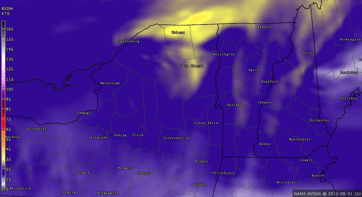
Animation of the HiRes NAM model picking up the 850mb winds that morning. Not going to be an exact like on location but watch the yellows and oranges show up in the ADK's at that time as the dry front pushed south.
Spoiler
Quote:
Originally Posted by NorthStarDelight
Sounds like an awesome day - I wanna climb Mt Marcy...lol. Can't believe you drove 4.5 hours and hiked for 8 and drove 4.5 back - isn't there any place to stay near the base?
Great pics, btw - I'd preferred a clear day myself for the views, but the coolness and wind is always nice.
Oh, the day I went to Lake Placid ('11) - it was 91 in town, and about 65 on the top of Whiteface Mtn - it was clouded over and windy at the top as well. I'd not been complaining about a 72...lol.
Drive wasn't bad but definitely sucks to be that far from the ADKs. Plenty of places to stay and even camp there but we didn't want or need to. When time isn't a factor for me, maybe. I didn't even touch on the wilderness area up there with no congestion, air, roads and residents.
Ahh, you did Whiteface? Cool. There's an ADK46 club. I got 2 down now. lol. There were other trails leading to other summits but our focus was on the longest and tallest one. I have hiked the highest mountain in CT, MA & NY now. VT Next?
I attached a camera to the front of my car. Got a cool timelapse video I need to make. Here's 1 shot of the fog we were going through along I87 Hudson Valley.
Right before we got there as the sun was coming up. Notice the temp differences. That's another mountain showing here
Ready to see all the cool places I visited on my 2-week grand northern adventure?
Will do this in chunks - starting with SE Michigan, where I visited with my uncle for 3 days before continuing on to Ontario for 3 more days. (August 19th onwards.)
Rolling into Cincinnati. Got there at a good time (after peak am rush), since I left at 3:30 am. I arrived in Birmingham, MI at 2:15 PM, a journey of 10h45m. Not too bad for 735 miles...lol.
This was taken the morning of the 20th, the first day of a 9-day run of *superb, wonderful* summer weather. Summer as it should be, baby. Nice and cool in the mornings (50's and low 60's) - warm but not hot in the daytime. (70's to near 80.) SE Michigan had been getting plenty of rain prior to my arrival, so everything was nice and green. It rained quite a bit on my first night there, leading to the exceedingly pleasant weather in the days ahead.
The creek we went for a kayak ride on. Temps were in the 70's - perfect for being on the water.
This was taken on the morning I left for Canada. Gorgeous temps in the 50's - couldn't have been any better for a nice little bike ride (one of several we did - only took my camera on one...lol). This monument is in downtown Birmingham - a wonderful suburban town of the metro area. Expensive place to live though - outa my price range...lol.
A pond just down the hill from the downtown. Lovely. No people around, either.
My first morning in another "B" town - Burlington, Ontario. This the view from my friend's 8th-floor apartment. If you look close, you can see Lake Ontario. With binoculars, it's a cinch to pick out the towers of Niagara Falls, an hour away by car.
The town of Port Dover, on the northern shore of Lake Erie. It's famous for the Friday the 13th biker rallies with 1000's of motorcycles.
The view of the lake from the pier. Amazing how clear it was. And how cool it was.
We rode farther on down to Long Point, a sandy spit that juts out into the lake. Apparently, it's quite popular as a camping and beach resort. It started to feel a bit warm on the beach, but it wasn't hot even in the sun. We started heading back soon thereafter (didn't go for a swim, although I could have - water temps were certainly in the 70's.)
Who says Canada doesn't have beaches?
Look at that nice, blue water. And that's the US in the far distance.
It being a body of fresh water, the forest grows right on the dunes - pretty neat.
A view of Hamilton on the way back.
Part of the neighborhood trail system in Burlington.
That's it for now - will post more later.
Last edited by NorthStarDelight; 09-02-2015 at 12:43 PM..
The smell oozing from stagnant water in the riverbed that goes through the city wasn't the most pleasant. One of the drawbacks of mediterranean climates.
Container handling cranes in the background. The port is closer from the city than I expected.
Huge magnolias there.
Landscape getting drier around Alicante. Southeastern Spain looks drier than I expected. The whole area between Alicante and Malaga is similar to how I imagined the Tabernas desert to be.
Higher ground is greener.
Olive tree plantations between Granada and Cordoba. Chances are that the "100% local" olive oil sold in some fishy markets around Nice is from there.
Cordoba. 34°C/93°F that day. Below average.
Spoiler
I thought the city was renowned for its narrow streets?
Where are the people? In the shade? Then where are the trees?
I see, greenery is hidden behind the walls in patios and private gardens.
Meh. My streets are narrowed than theirs.
Getting there.
Refreshing sight.
Are these fields one stone's throw away from the city center?
Quote:
Originally Posted by Cambium
Trail got rocky
That's my favorite pic. I like those picturesque trails that cut through moist forests. Though it doesn't look like the most convenient trail to walk on.
Quote:
Originally Posted by NorthStarDelight
Rolling into Cincinnati. Got there at a good time (after peak am rush), since I left at 3:30 am. I arrived in Birmingham, MI at 2:15 PM, a journey of 10h45m. Not too bad for 735 miles...lol.
Wow, I expected that journey to take much longer. And already in Ohio at the end of the morning rush hour after leaving Atlanta in the wee hours of the morning? The US isn't that big of a country after all.
Quote:
It being a body of fresh water, the forest grows right on the dunes - pretty neat.
Wow, I expected that journey to take much longer. And already in Ohio at the end of the morning rush hour after leaving Atlanta in the wee hours of the morning? The US isn't that big of a country after all.
Maybe it's because I can f-l-y on those Interstates. Actually, southern Ohio isn't that far from northern GA - just look at a map. Getting through Ohio took a long, long time - made worse by construction (at least they're building a modern Interstate next to the old, crumbling one, kudos to them.)
Syracuse is nearly a 1000 miles from here, so it did take longer to come back.
Interesting about the trees on dunes - our ocean beaches just have grass and scrub on our dunes.
@Rozenn: Yes that looks dry and desert - like in Spain, but still nice. Lucky you to avoid 40c in Cordoba.
The extreme weather fan in me was hoping for hotter weather.
Quote:
Originally Posted by NorthStarDelight
Maybe it's because I can f-l-y on those Interstates. Actually, southern Ohio isn't that far from northern GA - just look at a map. Getting through Ohio took a long, long time - made worse by construction (at least they're building a modern Interstate next to the old, crumbling one, kudos to them.)
Syracuse is nearly a 1000 miles from here, so it did take longer to come back.
Interesting about the trees on dunes - our ocean beaches just have grass and scrub on our dunes.
Yeah, they aren't that far apart after all, about as big a distance as ATL to central Florida. But Ohio sounds pretty northern to me, whereas Atlanta is obviously southern and having to cross two states makes it seem quite far away. Though both TN and KY are long and narrow.
Look at that nice, blue water. And that's the US in the far distance.
That's probably Pennsylvania in the distance, because it's the closest state to Long Point. The Allegheny Plateau rises pretty rapidly away from Lake Erie, so you can see how parts of northwestern Pennsylvania average more than 100" of mostly lake-effect snow every winter.
Maybe my eyes are fooling me, but if you look toward the right side of the picture where the water meets the ridge in the distance, you can see a thin band of a different color between the two. I wonder if that's Presque Isle? The distance between Long Point and Presque Isle is 25 miles.
Quote:
Originally Posted by Rozenn
Wow, I expected that journey to take much longer. And already in Ohio at the end of the morning rush hour after leaving Atlanta in the wee hours of the morning? The US isn't that big of a country after all.
Cincinnati and southern Ohio are actually farther south than many people realize. If you drive at the speed limit, Cincinnati is about seven hours north of Atlanta on I-75. It still takes almost 12 hours to get from Atlanta to either Chicago or Detroit. Detroit is another four-and-a-half hours north on I-75 from Cincinnati.
Last edited by Craziaskowboi; 09-02-2015 at 02:10 PM..
Please register to post and access all features of our very popular forum. It is free and quick. Over $68,000 in prizes has already been given out to active posters on our forum. Additional giveaways are planned.
Detailed information about all U.S. cities, counties, and zip codes on our site: City-data.com.

 Please register to participate in our discussions with 2 million other members - it's free and quick! Some forums can only be seen by registered members. After you create your account, you'll be able to customize options and access all our 15,000 new posts/day with fewer ads.