Welcome to City-Data.com Forum!
U.S. CitiesCity-Data Forum Index
Go Back   City-Data Forum > General Forums > Weather
 [Register]
Please register to participate in our discussions with 2 million other members - it's free and quick! Some forums can only be seen by registered members. After you create your account, you'll be able to customize options and access all our 15,000 new posts/day with fewer ads.
View detailed profile (Advanced) or search
site with Google Custom Search

Search Forums  (Advanced)
Reply Start New Thread
 
Old 12-07-2014, 11:43 AM
nei nei won $500 in our forum's Most Engaging Poster Contest - Thirteenth Edition (Jan-Feb 2015). 

Over $104,000 in prizes has already been given out to active posters on our forum and additional contests are planned
 
Location: Western Massachusetts
45,983 posts, read 53,765,156 times
Reputation: 15184

Advertisements

local NWS now has posted a Hazardous Weather Outlook:

HIGH CONFIDENCE THAT A STRONG COASTAL STORM WILL IMPACT OUR REGION
TUESDAY INTO TUESDAY EVENING. THE MAIN CONCERNS ARE AS FOLLOWS:

(1) HEAVY RAIN MAY RESULT IN SOME URBAN AND POOR DRAINAGE STREET
FLOODING ON TUESDAY INTO TUESDAY EVENING.

(2) A PERIOD OF ACCUMULATING WET SNOW IS POSSIBLE ACROSS
NORTHWEST AND NORTH CENTRAL MASSACHUSETTS ON TUESDAY. THAT IS
UNCERTAIN AND SMALL SHIFT IN THE TRACK COULD MAKE THE DIFFERENCE
BETWEEN A COLD RAIN OR 2 INCH PER HOUR SNOWFALL RATES FOR A TIME.

(3) NORTHEAST WIND GUSTS OF 40 TO 55 MPH ARE EXPECTED ALONG THE
EASTERN MASSACHUSETTS...INCLUDING THE CAPE AND ISLANDS ON TUESDAY
INTO TUESDAY EVENING. A WIND ADVISORY WILL LIKELY BE NEEDED WITH
EVEN A LOW PROBABILITY FOR A HIGH WIND WATCH.

(4) THERE IS THE POTENTIAL FOR AT LEAST SOME MINOR COASTAL
FLOODING AND BEACH EROSION ALONG THE EASTERN MASSACHUSETTS COAST
DURING THE MIDDAY HIGH TIDE CYCLE ON TUESDAY. A LOW PROBABILITY
EXISTS FOR SOME MODERATE COASTAL FLOODING ON TUESDAY IF WINDS
INCREASE A BIT EARLIER THAN EXPECTED.
Reply With Quote Quick reply to this message

 
Old 12-07-2014, 11:47 AM
 
Location: New Jersey
15,318 posts, read 17,293,217 times
Reputation: 6959
Current Hazardous Weather Outlook for this area:

HIS HAZARDOUS WEATHER OUTLOOK IS FOR NORTHERN NEW
JERSEY...NORTHWEST NEW JERSEY...EAST CENTRAL
PENNSYLVANIA...NORTHEAST PENNSYLVANIA AND SOUTHEAST PENNSYLVANIA.

.DAY ONE...TODAY AND TONIGHT.

THE PROBABILITY FOR HAZARDOUS WEATHER IS LOW.

.DAYS TWO THROUGH SEVEN...MONDAY THROUGH SATURDAY.

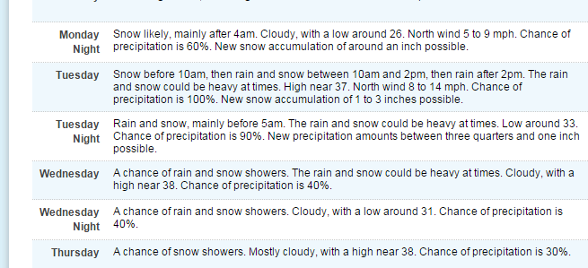
A WINTRY MIX IS POSSIBLE MONDAY NIGHT INTO WEDNESDAY MORNING WITH SOME
ACCUMULATION OF SNOW AND ICE. THIS EVENT COULD FEATURE ELEVATION
DEPENDENT HEAVY WET SNOW.

A BIT OF SNOW AND ICE SHOULD OCCUR EARLY TUESDAY MORNING AND THEN
A POTENTIALLY MUCH LARGER IMPACT FROM ELEVATION DEPENDENT WET SNOW
COULD OCCUR LATE TUESDAY AFTERNOON INTO WEDNESDAY MORNING.

FUTURE FORECASTS OF THIS STORM SHOULD BE MONITORED FOR POSSIBLE
IMPACTS ON THIS AREA.

Forecast:

Reply With Quote Quick reply to this message
 
Old 12-07-2014, 11:55 AM
 
Location: Near the Coast SWCT
83,694 posts, read 76,083,066 times
Reputation: 16713
Nice guys! Keep em coming.

Bernie Video. He mentions time frames and locations. Soaking rain for CT but I still feel Wednesday we see snow falling,. He thinks Philly too. Not a big deal at all. Just enough to get us in the winter spirits.


https://www.youtube.com/watch?v=bs2glTPE8_g&feature=youtu.be

Some Snow totals maps are out from NWS:

NWS Albany: http://www.erh.noaa.gov/aly/Past/Snow_PNS/WSW.htm
NWS Boston: http://www.weather.gov/images/box/winter/StormTotalSnowRange.png
NWS NY: http://www.erh.noaa.gov/okx/stormtotalprecip.php

NWS NJ: http://www.erh.noaa.gov/phi/StormTotalSnow/stormtotal.php

NWS Vermont: http://www.weather.gov/btv/stormtotalsnow
NWS Maine: http://www.erh.noaa.gov/gyx/StormTotalSnow/StormTotalSnow.php

NWS PA: http://www.weather.gov/ctp/WinterHazards
Reply With Quote Quick reply to this message
 
Old 12-07-2014, 12:08 PM
 
Location: Near the Coast SWCT
83,694 posts, read 76,083,066 times
Reputation: 16713
Here we go. Would be more excited to me if I was getting snow but this is special.

They are sending flights out to grab more atmospheric data to put into the models for this storm. Leaving Miami Florida dropping the tube at 34N/72.3W


Plan of the Day


WEATHER RECONNAISSANCE FLIGHTS
CARCAH, NATIONAL HURRICANE CENTER, MIAMI, FL.
0130 PM EST SUN 07 DECEMBER 2014
SUBJECT: WINTER STORM PLAN OF THE DAY (WSPOD)
VALID 08/1100Z TO 09/1100Z DECEMBER 2014
WSPOD NUMBER.....14-007

I. ATLANTIC REQUIREMENTS
1. FLIGHT ONE -- TEAL 71
A. A62/ DROP 7 (34.0N 72.3W)/ 09/0000Z
B. AFXXX 02WSA TRACK62
C. 08/1830Z
D. 10 DROPS AS PUBLISHED ON TRACK
E. AS HIGH AS POSSIBLE/ 09/0200Z
Reply With Quote Quick reply to this message
 
Old 12-07-2014, 03:18 PM
 
Location: New Jersey
15,318 posts, read 17,293,217 times
Reputation: 6959
Winter Storm Watches in Upstate NY and Eastern PA. Looking dicey here as well. Wonder if the storm watches will 'cross the river' into NJ.
Reply With Quote Quick reply to this message
 
Old 12-07-2014, 03:43 PM
 
Location: Near the Coast SWCT
83,694 posts, read 76,083,066 times
Reputation: 16713
Quote:
Originally Posted by ilovemycomputer90 View Post
Winter Storm Watches in Upstate NY and Eastern PA. Looking dicey here as well. Wonder if the storm watches will 'cross the river' into NJ.
I think our chance comes at the backside of it. There's too much warm air being pushed.

Here's latest GFS snow total projection.


Future radar loop. I find what's happening in the Atlantic interesting...

Watch the moisture and flow move "south" and then it gets sucked into the Northeast as the storm develops off the coast and the Upper Low moves towards it from Canada.

Its moving south right now because there's a fresh strong High pressure to the North.

Reply With Quote Quick reply to this message
 
Old 12-07-2014, 03:49 PM
 
Location: New Jersey
15,318 posts, read 17,293,217 times
Reputation: 6959
Quote:
Originally Posted by Cambium View Post
I think our chance comes at the backside of it. There's too much warm air being pushed.

Here's latest GFS snow total projection.


Future radar loop. I find what's happening in the Atlantic interesting...

Watch the moisture and flow move "south" and then it gets sucked into the Northeast as the storm develops off the coast and the Upper Low moves towards it from Canada.

Its moving south right now because there's a fresh strong High pressure to the North.
Even if 'wintry' weather is minimal in our areas, it still looks like we might get another soaking rain.
Reply With Quote Quick reply to this message
 
Old 12-07-2014, 05:08 PM
 
Location: Near the Coast SWCT
83,694 posts, read 76,083,066 times
Reputation: 16713
Will there be some surprises?


"ECMWF Ensembles getting a little more aggressive with this week's coastal storm for the Northeast"

https://twitter.com/MJVentrice/statu...241472/photo/1

Reply With Quote Quick reply to this message
 
Old 12-07-2014, 05:22 PM
 
Location: Near the Coast SWCT
83,694 posts, read 76,083,066 times
Reputation: 16713
NWS Binghamton snow total forecast. I wish i was living in areas under the purples.


NWS Albany snow total. Will Albany get screwed?

Reply With Quote Quick reply to this message
 
Old 12-08-2014, 04:58 AM
 
Location: Near the Coast SWCT
83,694 posts, read 76,083,066 times
Reputation: 16713
Latest Snow total forecasts pieced together from NWS Albany, Burlington, Gray and Caribou.

Click these links for updates. They sometimes change them throughout each day but since we're closer to the event it might not be changed too much.

Burlington: WFO BTV Storm Total Snow Forecast
Albany: Winter Storm Graphics
Gray: National Weather Service Forecast Office - Portland-Gray,Maine
Caribou: NOAA's NWS Forecast Office—Caribou, Maine—Storm Total Snowfall Forecast

Reply With Quote Quick reply to this message
Please register to post and access all features of our very popular forum. It is free and quick. Over $68,000 in prizes has already been given out to active posters on our forum. Additional giveaways are planned.

Detailed information about all U.S. cities, counties, and zip codes on our site: City-data.com.


Reply
Please update this thread with any new information or opinions. This open thread is still read by thousands of people, so we encourage all additional points of view.

Quick Reply
Message:


Over $104,000 in prizes was already given out to active posters on our forum and additional giveaways are planned!

Go Back   City-Data Forum > General Forums > Weather
Similar Threads

All times are GMT -6.

© 2005-2024, Advameg, Inc. · Please obey Forum Rules · Terms of Use and Privacy Policy · Bug Bounty

City-Data.com - Contact Us - Archive 1, 2, 3, 4, 5, 6, 7, 8, 9, 10, 11, 12, 13, 14, 15, 16, 17, 18, 19, 20, 21, 22, 23, 24, 25, 26, 27, 28, 29, 30, 31, 32, 33, 34, 35, 36, 37 - Top