Please register to participate in our discussions with 2 million other members - it's free and quick! Some forums can only be seen by registered members. After you create your account, you'll be able to customize options and access all our 15,000 new posts/day with fewer ads.
Thicker blue line is the freezing line for 4000'. Thinner blue line is the freezing line for the surface. Thin red lines are the temps at 4000s above 0°C, you can see the numbers in red.
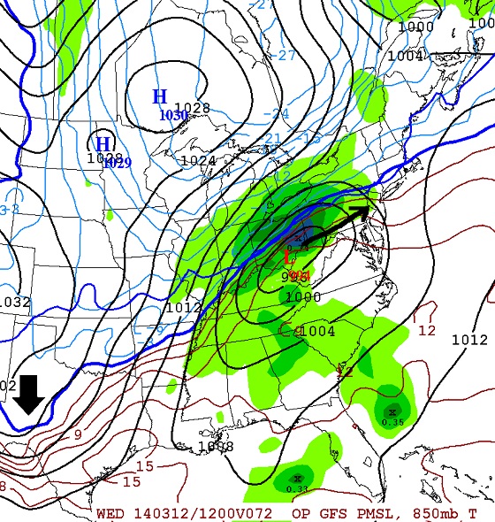
Here is Wednesday 1am. Low pressure system in Tennessee River Valley. It's snowing across northern Missouri, Illinois, Indiana. Raining in southern parts of the states. Notice it's above freezing from about Allentown southward.
Here is Wednesday 8am. Center of low is now over southern Ohio. Light snow breaking out across NW NJ and central NY. Snowing heavy in northern Ohio. Raining heavy in Pittsburgh.
Notice the freezing line at 850mb digs down into Texas.
This is Wednesday 5pm. Storm center now entering NJ. Look where the freezing line is now. Pushed well north of NJ. Its across northern MA now. So it's raining across all of NJ, southern NY, CT, RI up and down the coastal plain
Pittsbugh changed to snow at this point because cold air came back in on the back side. It's snowing across New England at this point, mixing around MA, Raining in big cities.
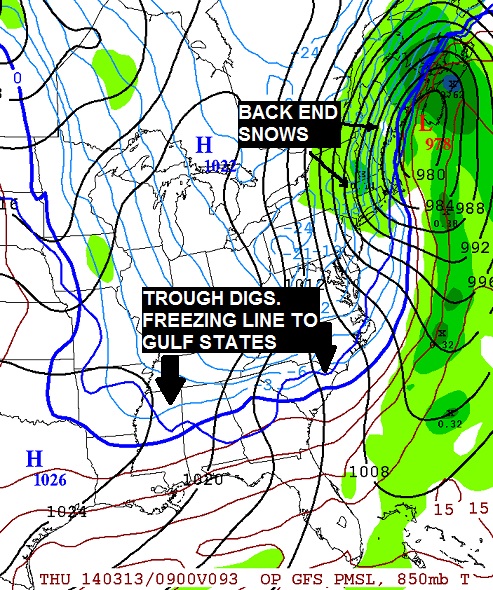
This is Thursday 5am. Strong storm now off the coast of Maine. 978mb low! Notice the freezing line digs down to gulf states but notice precip lingering around behind the storm. With the cold air moving in this would be snow NYC northward early Thursday morning. Blizzard conditions somewhere in Maine and Canada there.
This is not a forecast or guarantee. It's what is looked at to create a forecast.
Obviously this is just from the GFS. Other models might have different senarios and timing. Tonight's GFS might look different as well.
Looks to be over an inch liquid with this system. So it will mean a lot of rain or a lot of snow for those that stay snow.
Cambo, you think we are going to have snow in Chicago, but NWS right now forecasts mainly rain Tuesday with only some snow mix Tuesday night. Only a slight chance of snow on Wednesday. I wonder where exactly that rain/snow line will fall.
Quote:
Originally Posted by G8RCAT
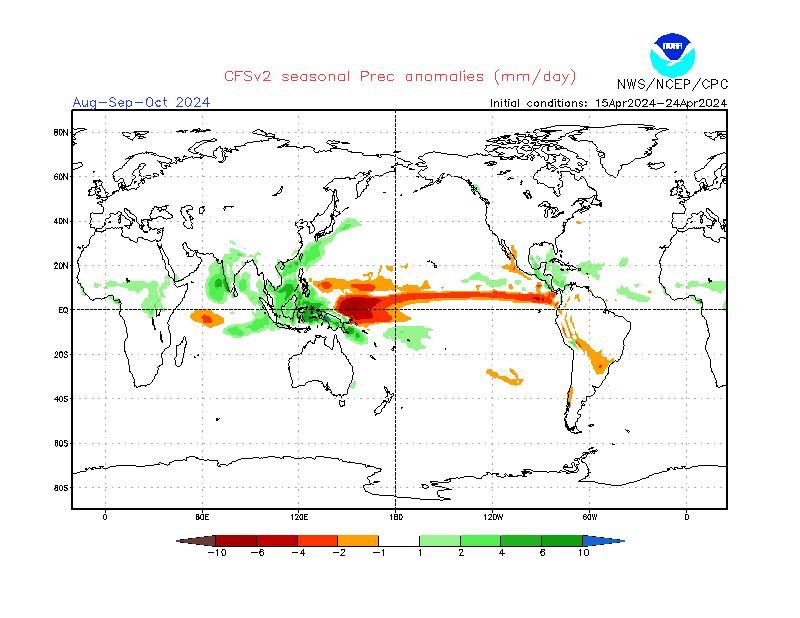
Are there any maps regarding summer precipitation?
CFSv2 does produce it, but I'm not sure how much skill there is in forecasting regional precip values. Truth be told, I don't think there is much skill in forecasting temperatures 3-6 months out either.
Cambo, you think we are going to have snow in Chicago, but NWS right now forecasts mainly rain Tuesday with only some snow mix Tuesday night. Only a slight chance of snow on Wednesday. I wonder where exactly that rain/snow line will fall.
Rain to start because temps might not support snow when the initial precip moves in. Notice the 1st frame I posted is for Wed 1am, that's when it would be snowing there. It's actually dry for ORD so maybe a drizzle to start. I think they are playing it ok based on the forecast you posted. GFS says its out of there by Wednesday Morning.
Timing looks better for you then me. Bulk of it arrives in afternoon here not night and in March that's bad timing if you want snow.
CFSv2 does produce it, but I'm not sure how much skill there is in forecasting regional precip values. Truth be told, I don't think there is much skill in forecasting temperatures 3-6 months out either.
But here it is
Hmm, so basically nothing noteworthy. I'm just trying to see how good the chance is of having a lot of wet Gulf air masses vs from the north.
Rain to start because temps might not support snow when the initial precip moves in. Notice the 1st frame I posted is for Wed 1am, that's when it would be snowing there. It's actually dry for ORD so maybe a drizzle to start. I think they are playing it ok based on the forecast you posted. GFS says its out of there by Wednesday Morning.
Timing looks better for you then me. Bulk of it arrives in afternoon here not night and in March that's bad timing if you want snow.
Timing is everything for snow chances by this time of year.
No idea what he's talking about. Whats a test case on vender site?
He's nuts. It's fun to look at solutions like that but to tweet it to the public for what? You should ask him what the consensus is and how many others support that solution/amount.
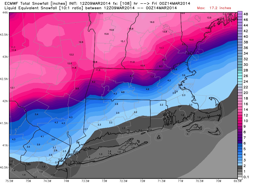
I was going to post the Euro snow totals but its less than an inch around Chicago so I wont bother since it's no big deal.
Here's the Northeast. The 2" for me is the backside snows. New England gonna get hammered
The Track is not favoring the coastal areas. It's not the Calendar, It's not what Climo says... Simply the track this time. A shift south by 75 miles and I'm in!
WEDNESDAY AND WEDNESDAY NIGHT...MODELS ARE IN BETTER AGREEMENT IN BRINGING A SURFACE LOW OVER THE OHIO VALLEY EARLY WEDNESDAY AND MOVING IT JUST NORTH OF THE BENCHMARK (40N 70W) BY LATE WEDNESDAY NIGHT. THUS...FORECASTER CONFIDENCE IS ALSO HIGHER.
THIS LOW TRACK WILL BRING A SIGNIFICANT SNOWFALL FOR VERMONT AND NORTHERN NEW YORK WEDNESDAY, WEDNESDAY NIGHT AND EARLY THURSDAY.
ALL THE MODELS...ECMWF...GFS AND CANADIAN GLOBAL MODEL ALL SHOW THE TRACK OF THE LOW JUST NORTH OF THE BENCHMARK ON WEDNESDAY.
THE ECMWF MODEL HAS THE HIGHEST QPF WITH THIS SYSTEM...
THE GFS AND CANADIAN GLOBAL MODELS SHOWING LESS QPF.
THUS...AT THIS TIME IT IS STILL TOO EARLY TO FORECAST HOW MUCH SNOW WILL FALL...BUT IT DOES LOOK LIKE A SIGNIFICANT AND PLOWABLE SNOWFALL FOR THE REGION WEDNESDAY AND WEDNESDAY NIGHT.
IF LATER MODEL TRENDS CONTINUE TO SHOW THIS POTENTIAL...THEN A WINTER STORM WATCH MAY NEED TO BE ISSUED. MODELS SHOW SNOW WILL CONTINUE INTO THURSDAY MORNING BEFORE TAPERING OFF THURSDAY AFTERNOON
As per usual after having a winter umpteen degrees warmer than average with daffodils out in January alongside Roses and Cherry blossoms we get the ice cold weather arriving in bloody April when we are heading to summer!
No idea what he's talking about. Whats a test case on vender site?
He's nuts. It's fun to look at solutions like that but to tweet it to the public for what? You should ask him what the consensus is and how many others support that solution/amount.
He was comparing his former company's forecast (I believe) for Chicago (test case) from a few days ago, and how it's changed dramatically. He is implying that the met guys over there have their hands tied to using model generated forecasts without being able to put in their own inclinations.
Quote:
I was going to post the Euro snow totals but its less than an inch around Chicago so I wont bother since it's no big deal.
Here's the Northeast. The 2" for me is the backside snows. New England gonna get hammered
12z gfs does show stronger storm west though, so maybe there is something to what he tweeted.. IDK
Still doesn't seem like a big deal to me
Last edited by chicagogeorge; 03-09-2014 at 02:51 PM..
NAM was the first one I saw that was right with the last storm giving us nothing here when forecasts and models showed 6-12" days before.
Here's what latest NAM says for Wednesday. It looks a bit colder.
remember, this is based on 10:1 ratios. most likely it will be close to 7:1 near here so cut the totals off a couple inches.
This doesn't look like a NJ or Long Island storm. I would even rule out NYC but a shift south by not much might give them a little surprise.
Please register to post and access all features of our very popular forum. It is free and quick. Over $68,000 in prizes has already been given out to active posters on our forum. Additional giveaways are planned.
Detailed information about all U.S. cities, counties, and zip codes on our site: City-data.com.

 Please register to participate in our discussions with 2 million other members - it's free and quick! Some forums can only be seen by registered members. After you create your account, you'll be able to customize options and access all our 15,000 new posts/day with fewer ads.


 LOL
LOL


