Fall 2012 Thread (September - November) (Delaware, snow, warm, days)
Please register to participate in our discussions with 2 million other members - it's free and quick! Some forums can only be seen by registered members. After you create your account, you'll be able to customize options and access all our 15,000 new posts/day with fewer ads.
Fog is pretty common here, but I don't think it is in Skipton. All day fog events are not rare here, I remember a spell in Feb 2011 when we had almost a week of fog. Max was 10.1c
? Not believing it still but a few more times showing a Hurricane on the coast and my confidence grows.
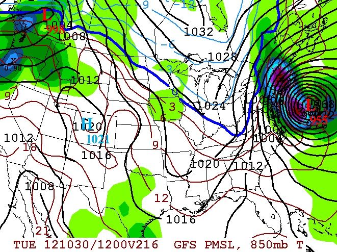
To give some credit to the GFS, it was showing a Tropical System come from the Pacific and cross down south and come up the coast.. Now its showing a Hurricane in Atlantic blow up on the coast.
So to me that is a signal that something could happen along the coast.. It's picking up an enviroment favoring this.
This would be the Nov. 1st time frame. It actually stalls it too. (never a good thing)
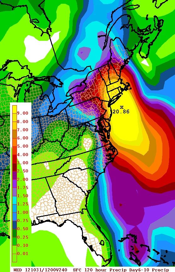
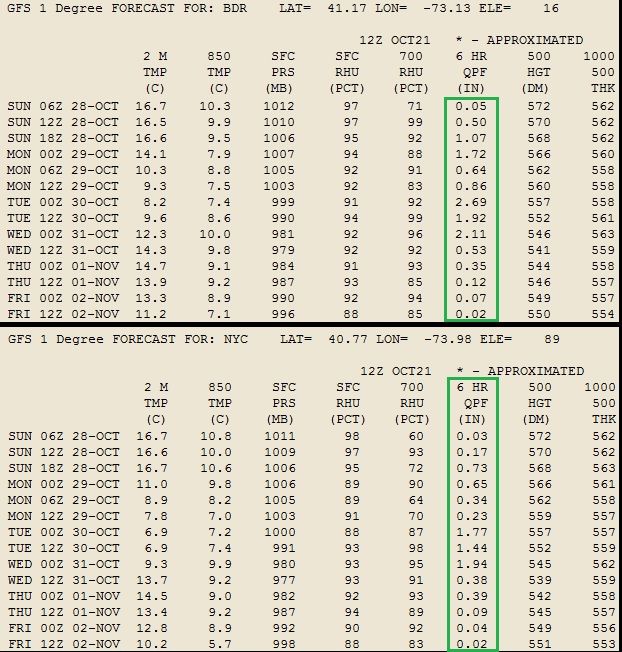
NYC and Bridgeport,CT data output from that GFS run. Anyone want to calculate what the rain totals come out to in that 4-5 day period? I believe its 3 months worth but I'm not buying it so I'm not spending too much time on it.
? Not believing it still but a few more times showing a Hurricane on the coast and my confidence grows.
To give some credit to the GFS, it was showing a Tropical System come from the Pacific and cross down south and come up the coast.. Now its showing a Hurricane in Atlantic blow up on the coast.
So to me that is a signal that something could happen along the coast.. It's picking up an enviroment favoring this.
This would be the Nov. 1st time frame. It actually stalls it too. (never a good thing)
Put it this way...Irene was a 973mb Low.
GFS12z
Temps during this timeframe too warm for snow I believe, correct and from what I see this may hit us with some rain but more out to sea than a direct hit?
The Euro Just came out, now shows it as well. Dear Lord.
I started a Hurricane thread because this system would be Hurricane Sandy. Without complicating or cluttering this thread, I will post updates here. Feel free to follow the topic to get an email when something is posted in it. https://www.city-data.com/forum/hurri...er-2012-a.html
Temps during this timeframe too warm for snow I believe, correct and from what I see this may hit us with some rain but more out to sea than a direct hit?
Yes, temps way too warm for snow but winds and rain we all know the drill at that strength. However, Euro seems to have back side snows because the thing stalls and gets engulfed into the Trough.
I'm not liking this "stall" idea with the models, that keeps things interesting but not good for flooding and wind damage
Path shouldnt be looked at yet, we wont know that until a couple days before if its a direct hit or not.
There looks to be a MAJOR TRAFFIC JAM in the air because of that blocking which would lead to a stall.
It's still 7-10 days away so lets keep watching this evolution.
The peak foliage is almost over... soon it'll be the boring part of fall. Other than the chance of seeing flurries here and there, all next month will be good for is waiting for winter to come.
Happy. It is going to be sunny tomorrow, so one more sunny day than planned.
Cold spell still coming. Will have to get ready for that.
Please register to post and access all features of our very popular forum. It is free and quick. Over $68,000 in prizes has already been given out to active posters on our forum. Additional giveaways are planned.
Detailed information about all U.S. cities, counties, and zip codes on our site: City-data.com.

 Please register to participate in our discussions with 2 million other members - it's free and quick! Some forums can only be seen by registered members. After you create your account, you'll be able to customize options and access all our 15,000 new posts/day with fewer ads.


")