Please register to participate in our discussions with 2 million other members - it's free and quick! Some forums can only be seen by registered members. After you create your account, you'll be able to customize options and access all our 15,000 new posts/day with fewer ads.
Atlanta is the only one of the four mentioned that isn't "big and spread out". Atlanta is a little larger than St. Louis, but not nearly as large as Houston/LA/NYC. Atlanta has three major employment centers ("downtowns") within the 132 square-mile city limits, and three other ones in the suburbs that are similar to Clayton.
St. Louis is also 60 sq miles, so Atlanta is more than twice as big, but you're right, it is a lot smaller than those other cities.
Quote:
Originally Posted by imperialmog
Also in the St. Louis example. Part of the reason Clayton is outside city limits is due to a city/county divorce in the 1870's, otherwise Clayton would certinly be in the city now. Clayton does function as a 2nd CBD and not a edge city pattern due to some unique issues in the region.
Also are some of these pictures something else if the high-rises are not offices but residental structures? In St. Louis the two high-rise areas between Downtown St. Louis and Clayton (Midtown and CWE) are mainly residental buildings.
Central West End has a lot of hospital buildings. They're a part of Barnes Jewish Hospital and St. Louis Children's Hospital. There are also buildings for many other medical facilities
The high-rises in Midtown are mostly dorms and apartments around SLU's campus. SLU has a lot of high-rises for a college campus
Detroit has a few CBD's with their own skylines
There's Downtown, Midtown, and New Center, Lafayette Park and the East Riverfront.
However, I'm barely qualifying midtown but because it's in the central (what I call) business corridor, I'll add it.
Downtown:
Detroit Skyline on Flickr - Photo Sharing! (http://www.flickr.com/photos/alanguir/4120991457/ - broken link)
Midtown: (Note the New Center is seen obviously, the Midtown skyline is the foreground and the right part with the cluster of buildings)
Midtown & New Center on Flickr - Photo Sharing! (http://www.flickr.com/photos/snweb/415214131/ - broken link)
http://www.flickr.com/photos/snweb/416125815/in/photostream/ (broken link)
New Center:
new center on Flickr - Photo Sharing! (http://www.flickr.com/photos/southen/4069241070/ - broken link)
Lafayette Park:
Detroit Looking Northeast on Flickr - Photo Sharing! (http://www.flickr.com/photos/22176685@N07/3391743413/ - broken link)
Boston has the Financial District and the Back Bay.
Generally speaking, dowtown Boston is where Government Center [City Hall, Fanueil Hall] is located, the Financial District surrounds the neighborhood of Downtown Crossing, and the Back Bay is centered around Copely Square about 2 miles west.
Well DC has dowtown as in Conneticut Avenue, Dupont Circle etc but it also has Georgetown. But to get technical, you also have Rosslyn and Old town Alexandria which is still part of the general Metroplitan area.
San Francisco has different urban subsections like the Castro, Haight Asbury, North Beach, Chinatown etc.
And New York has many, not only in Manhattan, but in Brooklyn, Queens and the Bronx.
Location: Austin, TX/Chicago, IL/Houston, TX/Washington, DC
10,138 posts, read 16,123,140 times
Reputation: 4047
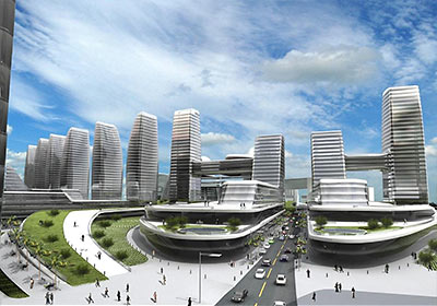
Houston's in the process of getting another skyline/business district, but this one is a master planned one at that with upscale shopping, hotels, restaurants, etc..:
My guess is this is a trend that will continue going on and also have similar things in suburbs. It is part of not having one central business district with a hub-and-spoke planning modal and more of a "galactic" model of multiple centers with suburbs of various density in between. The big problem is that transportation and especially mass-transit is designed for the former model and doesn't serve the second type too well in most cases. It is a reason why mass transit isn't utilized as much since it doesn't serve these outer centers of employment well for commuting purposes. These locations should have multiple express bus/rail lines meeting there making mass transit more practical to people who work or live in these centers. Actually commuting from two points outside the central core area in most cities is not practical to take mass transit unless it is in the direction of the central core due to how systems are designed.
Please register to post and access all features of our very popular forum. It is free and quick. Over $68,000 in prizes has already been given out to active posters on our forum. Additional giveaways are planned.
Detailed information about all U.S. cities, counties, and zip codes on our site: City-data.com.

 Please register to participate in our discussions with 2 million other members - it's free and quick! Some forums can only be seen by registered members. After you create your account, you'll be able to customize options and access all our 15,000 new posts/day with fewer ads.