Bridge Statistics for Atlanta, Georgia (GA)
Condition, Traffic, Stress, Structural Evaluation, Project Costs
- National Bridge Inventory (NBI) Statistics
- 943Number of bridges
- 11,804ft / 3,598mTotal length
- $2,063,749,000Total costs
- 46,196,877Total average daily traffic
- 629,964Total average daily truck traffic
- National Bridge Inventory (NBI) Registered Bridges for Atlanta
- No street view available for this location
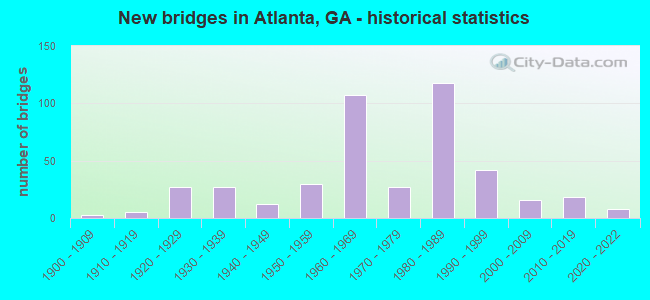
- New bridges - historical statistics
- 31900-1909
- 51910-1919
- 271920-1929
- 271930-1939
- 121940-1949
- 301950-1959
- 1071960-1969
- 271970-1979
- 1181980-1989
- 421990-1999
- 162000-2009
- 182010-2019
- 82020-2022
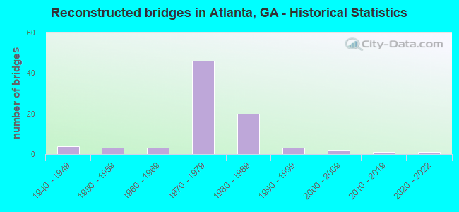
- Reconstructed bridges - Historical Statistics
- 41940-1949
- 31950-1959
- 31960-1969
- 461970-1979
- 201980-1989
- 31990-1999
- 22000-2009
- 12010-2019
- 12020-2022
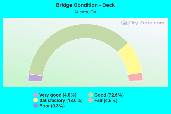
- Bridge Condition - Deck
- 4.0%Very good
- 72.6%Good
- 18.6%Satisfactory
- 4.5%Fair
- 0.3%Poor
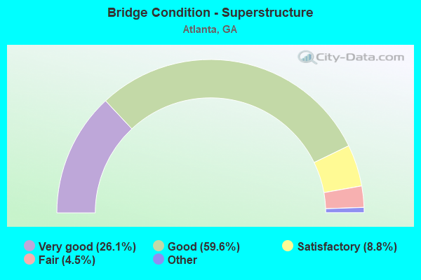
- Bridge Condition - Superstructure
- 26.1%Very good
- 59.6%Good
- 8.8%Satisfactory
- 4.5%Fair
- 1.1%Poor
- 0.3%Imminent failure
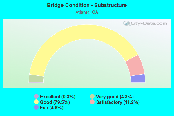
- Bridge Condition - Substructure
- 0.3%Excellent
- 4.3%Very good
- 79.5%Good
- 11.2%Satisfactory
- 4.8%Fair
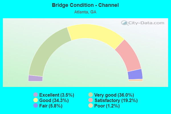
- Bridge Condition - Channel
- 3.5%Excellent
- 36.0%Very good
- 34.3%Good
- 19.2%Satisfactory
- 5.8%Fair
- 1.2%Poor
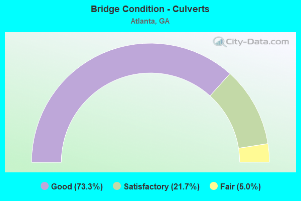
- Bridge Condition - Culverts
- 73.3%Good
- 21.7%Satisfactory
- 5.0%Fair
Find on map >> Show street view
Structure Number: 121063, Location: IN ALPHARETTA CTY LIMITS (Lat: 34.090872, Lng: -84.233353), Route carried "on" structure: City street 9284, Year Built: 1986, Status: Open, Structure Length: 4.51m (14.80ft), Average Daily Traffic: 12,980 (year 2012), Truck Traffic: 1%, Average Future Daily Traffic: 19,470 (year 2032), Design Load: HS 20, Features Intersected: BIG CREEK, Facility Carried by Structure: WINDWARD PKY (WBL)
Minimum Vertical Clearance: 30+ m (98+ ft), Kilometerpoint: 4.828, Lanes on structure: 2, Base Highway Network: Yes, Owner: City or Municipal Highway Agency, Approaching Roadway Width: 8.2m (26.9ft), Skew: 10 degrees, Material/Design: Prestressed concrete, Design/Construction: Box Beam or Girders - Multiple, Number Of Spans In Main Unit: 4, Length of Maximum Span: 11.3m (37.1ft), Curb-To-Curb Width: 9.9m (32.5ft), Out-to-Out Width: 11.9m (39.0ft)
Condition: Deck: Good, Superstructure: Good, Substructure: Good, Channel: Good, Operating Rating: 44.4 metric tons, Method Used To Determine Operating Rating: Load Factor (LF), Inventory Rating: 29.9 metric tons, Method Used To Determine Inventory Rating: Load Factor (LF), Structural Evaluation: Better than present minimum criteria, Deck Geometry: Meets minimum limits, Waterway Adequacy: Better than present minimum criteria, Approach Roadway Alignment: Equal to present desirable criteria, Designated Inspection Frequency: Every 24 months, Underwater Inspection Frequency: Every 60 months, Inspection Date: August 2021, Underwater Inspection Date: August 2018, Bridge Improvement Cost: $578,000, Roadway Improvement Cost: $58,000, Total Project Cost: $867,000, Deck Structure Type: Concrete Precast Panels, Wearing Surface/Protective System: Wearing Surface: Bituminous
Find on map >> Show street view
Structure Number: 1210631, Location: IN S ATLANTA (Lat: 33.698989, Lng: -84.404428), Route carried "on" structure: Ramp State highway 166, Year Built: 1987, Status: Open, Structure Length: 9.57m (31.40ft), Average Daily Traffic: 4,640 (year 2012), Truck Traffic: 1%, Average Future Daily Traffic: 6,960 (year 2032), Design Load: HS 20+Mod, Features Intersected: I-75- SR 166 RAMP
Minimum Vertical Clearance: 30+ m (98+ ft), Kilometerpoint: 24.140, Lanes on structure: 2, Lanes under structure: 15, Base Highway Network: Yes, Owner: State Highway Agency, Approaching Roadway Width: 12.8m (42.0ft), Skew: 1 degrees, Material/Design: Prestressed concrete continuous, Design/Construction: Box Beam or Girders - Single/Spread, Number Of Spans In Main Unit: 2, Length of Maximum Span: 48.5m (159.1ft), Curb-To-Curb Width: 12.8m (42.0ft), Out-to-Out Width: 13.8m (45.3ft)
Condition: Deck: Good, Superstructure: Good, Substructure: Good, Operating Rating: 46.2 metric tons, Method Used To Determine Operating Rating: Allowable Stress (AS), Inventory Rating: 32.6 metric tons, Method Used To Determine Inventory Rating: Allowable Stress (AS), Structural Evaluation: Better than present minimum criteria, Deck Geometry: Superior to present desirable criteria, Underclear: Equal to present minimum criteria, Approach Roadway Alignment: Better than present minimum criteria, Designated Inspection Frequency: Every 24 months, Inspection Date: March 2021, Deck Structure Type: Concrete Cast-file-Place, Wearing Surface/Protective System: Wearing Surface: Epoxy Overlay, Deck Protection: Epoxy Coated Reinforcing
Find on map >> Show street view
Structure Number: 1210632, Location: IN ATLANTA (Lat: 33.736875, Lng: -84.392028), Route carried "on" structure: Interstate 75, Year Built: 1987, Status: Open, Structure Length: 5.85m (19.19ft), Average Daily Traffic: 260,300 (year 2012), Truck Traffic: 1%, Average Future Daily Traffic: 390,450 (year 2032), Design Load: HS 20+Mod, Features Intersected: M-9053 GEORGIA AVE.
Minimum Vertical Clearance: 30+ m (98+ ft), Kilometerpoint: 395.899, Lanes on structure: 14, Lanes under structure: 7, Base Highway Network: Yes, Owner: State Highway Agency, Approaching Roadway Width: 64.0m (210.0ft), Skew: 30 degrees, Material/Design: Prestressed concrete, Design/Construction: Stringer/Multi-beam, Number Of Spans In Main Unit: 3, Length of Maximum Span: 36.6m (120.1ft), Curb-To-Curb Width: 67.8m (222.4ft), Out-to-Out Width: 69.9m (229.3ft)
Condition: Deck: Good, Superstructure: Good, Substructure: Good, Operating Rating: 46.2 metric tons, Method Used To Determine Operating Rating: Allowable Stress (AS), Inventory Rating: 32.6 metric tons, Method Used To Determine Inventory Rating: Allowable Stress (AS), Structural Evaluation: Better than present minimum criteria, Deck Geometry: Superior to present desirable criteria, Underclear: Somewhat better than minimum adequacy, Approach Roadway Alignment: Equal to present desirable criteria, Designated Inspection Frequency: Every 24 months, Inspection Date: May 2021, Bridge Improvement Cost: $3,205,000, Roadway Improvement Cost: $321,000, Total Project Cost: $4,808,000, Deck Structure Type: Concrete Cast-file-Place
Find on map >> Show street view
Structure Number: 1210633, Location: IN S ATLANTA (Lat: 33.686378, Lng: -84.401919), Route carried "on" structure: Interstate 85, Year Built: 1986, Status: Open, Structure Length: 1.49m (4.89ft), Average Daily Traffic: 92,000 (year 2012), Truck Traffic: 1%, Average Future Daily Traffic: 138,000 (year 2032), Design Load: HS 20+Mod, Features Intersected: SOUTH RIVER
Minimum Vertical Clearance: 30+ m (98+ ft), Kilometerpoint: 122.310, Lanes on structure: 6, Base Highway Network: Yes, Owner: State Highway Agency, Approaching Roadway Width: 33.2m (108.9ft), Skew: 19 degrees, Material/Design: Concrete, Design/Construction: Culvert, Number Of Spans In Main Unit: 4, Length of Maximum Span: 3.0m (9.8ft), Curb-To-Curb Width: 33.2m (108.9ft), Out-to-Out Width: 33.2m (108.9ft)
Condition: Channel: Good, Culverts: Good, Operating Rating: 55.3 metric tons, Method Used To Determine Operating Rating: Field evaluation and documented engineering judgment, Inventory Rating: 32.6 metric tons, Method Used To Determine Inventory Rating: Field evaluation and documented engineering judgment, Structural Evaluation: Better than present minimum criteria, Deck Geometry: Superior to present desirable criteria, Waterway Adequacy: Superior to present desirable criteria, Approach Roadway Alignment: Equal to present desirable criteria, Designated Inspection Frequency: Every 24 months, Inspection Date: March 2021
Find on map >> Show street view
Structure Number: 1210634, Location: IN S ATLANTA (Lat: 33.688708, Lng: -84.400058), Route carried "on" structure: Interstate 85, Year Built: 1987, Status: Open, Structure Length: 22.13m (72.60ft), Average Daily Traffic: 92,000 (year 2012), Truck Traffic: 1%, Average Future Daily Traffic: 138,000 (year 2032), Design Load: HS 20+Mod, Features Intersected: I-75- 2 I-75 RAMPS
Minimum Vertical Clearance: 30+ m (98+ ft), Kilometerpoint: 122.310, Lanes on structure: 2, Lanes under structure: 13, Base Highway Network: Yes, Owner: State Highway Agency, Approaching Roadway Width: 13.4m (44.0ft), Skew: 6 degrees, Material/Design: Prestressed concrete continuous, Design/Construction: Box Beam or Girders - Single/Spread, Number Of Spans In Main Unit: 4, Length of Maximum Span: 73.2m (240.2ft), Curb-To-Curb Width: 14.6m (47.9ft), Out-to-Out Width: 15.6m (51.2ft)
Condition: Deck: Good, Superstructure: Good, Substructure: Good, Operating Rating: 46.2 metric tons, Method Used To Determine Operating Rating: Allowable Stress (AS), Inventory Rating: 32.6 metric tons, Method Used To Determine Inventory Rating: Allowable Stress (AS), Structural Evaluation: Better than present minimum criteria, Deck Geometry: Superior to present desirable criteria, Underclear: Equal to present minimum criteria, Approach Roadway Alignment: Equal to present desirable criteria, Designated Inspection Frequency: Every 24 months, Inspection Date: April 2021, Deck Structure Type: Concrete Cast-file-Place, Wearing Surface/Protective System: Wearing Surface: Epoxy Overlay, Deck Protection: Epoxy Coated Reinforcing
Find on map >> Show street view
Structure Number: 1210639, Location: IN SOUTH ATLANTA (Lat: 33.688028, Lng: -84.399578), Route carried "on" structure: Ramp Interstate 85, Year Built: 1988, Status: Open, Structure Length: 16.76m (54.99ft), Average Daily Traffic: 4,640 (year 2012), Truck Traffic: 1%, Average Future Daily Traffic: 6,960 (year 2032), Design Load: HS 20+Mod, Features Intersected: I-75- 2 I-75 RAMPS
Minimum Vertical Clearance: 30+ m (98+ ft), Kilometerpoint: 122.310, Lanes on structure: 2, Lanes under structure: 13, Base Highway Network: Yes, Owner: State Highway Agency, Approaching Roadway Width: 12.2m (40.0ft), Skew: 5 degrees, Material/Design: Prestressed concrete continuous, Design/Construction: Box Beam or Girders - Single/Spread, Number Of Spans In Main Unit: 3, Length of Maximum Span: 70.7m (232.0ft), Curb-To-Curb Width: 12.8m (42.0ft), Out-to-Out Width: 13.8m (45.3ft)
Condition: Deck: Very good, Superstructure: Good, Substructure: Good, Operating Rating: 55.3 metric tons, Method Used To Determine Operating Rating: Load Factor (LF), Inventory Rating: 32.6 metric tons, Method Used To Determine Inventory Rating: Load Factor (LF), Structural Evaluation: Better than present minimum criteria, Deck Geometry: Superior to present desirable criteria, Underclear: Equal to present minimum criteria, Approach Roadway Alignment: Equal to present desirable criteria, Designated Inspection Frequency: Every 24 months, Inspection Date: March 2021, Deck Structure Type: Concrete Cast-file-Place, Wearing Surface/Protective System: Wearing Surface: Epoxy Overlay, Deck Protection: Epoxy Coated Reinforcing
Find on map >> Show street view
Structure Number: 121064, Location: IN COLLEGE PARK (Lat: 33.620458, Lng: -84.464119), Route carried "on" structure: Interstate 285, Year Built: 1988, Status: Open, Structure Length: 5.27m (17.29ft), Average Daily Traffic: 105,410 (year 2012), Truck Traffic: 1%, Average Future Daily Traffic: 158,115 (year 2032), Design Load: HS 20+Mod, Features Intersected: I-285 RMP TO I-85 SB
Minimum Vertical Clearance: 30+ m (98+ ft), Kilometerpoint: 99.779, Lanes on structure: 3, Lanes under structure: 1, Base Highway Network: Yes, Owner: State Highway Agency, Approaching Roadway Width: 18.3m (60.0ft), Skew: 7 degrees, Material/Design: Prestressed concrete, Design/Construction: Stringer/Multi-beam, Number Of Spans In Main Unit: 1, Length of Maximum Span: 52.7m (172.9ft), Curb-To-Curb Width: 17.7m (58.1ft), Out-to-Out Width: 18.7m (61.4ft)
Condition: Deck: Very good, Superstructure: Very good, Substructure: Good, Operating Rating: 55.3 metric tons, Method Used To Determine Operating Rating: Allowable Stress (AS), Inventory Rating: 32.6 metric tons, Method Used To Determine Inventory Rating: Allowable Stress (AS), Structural Evaluation: Better than present minimum criteria, Deck Geometry: Better than present minimum criteria, Underclear: Somewhat better than minimum adequacy, Approach Roadway Alignment: Equal to present desirable criteria, Designated Inspection Frequency: Every 24 months, Inspection Date: April 2021, Deck Structure Type: Concrete Cast-file-Place, Wearing Surface/Protective System: Wearing Surface: Bituminous, Membrane: Built-up, Deck Protection: Epoxy Coated Reinforcing
Find on map >> Show street view
Structure Number: 1210644, Location: IN ATLANTA (Lat: 33.765439, Lng: -84.385458), Route carried "on" structure: City street 9201, Year Built: 1987, Status: Open, Structure Length: 8.78m (28.81ft), Average Daily Traffic: 16,050 (year 2012), Truck Traffic: 1%, Average Future Daily Traffic: 24,075 (year 2032), Design Load: HS 20+Mod, Features Intersected: I-75, Facility Carried by Structure: PEACHTREE STREET
Minimum Vertical Clearance: 30+ m (98+ ft), Kilometerpoint: 0.000, Lanes on structure: 6, Lanes under structure: 15, Base Highway Network: Yes, Owner: State Highway Agency, Approaching Roadway Width: 19.5m (64.0ft), Skew: 3 degrees, Material/Design: Steel continuous, Design/Construction: Stringer/Multi-beam, Number Of Spans In Main Unit: 2, Length of Maximum Span: 46.0m (150.9ft), Curb or Sidewalk Widths: Left: 3.0m (9.8ft), Right: 3.0m (9.8ft), Curb-To-Curb Width: 20.1m (65.9ft), Out-to-Out Width: 26.9m (88.3ft)
Condition: Deck: Good, Superstructure: Good, Substructure: Good, Operating Rating: 49.8 metric tons, Method Used To Determine Operating Rating: Load Factor (LF), Inventory Rating: 29.9 metric tons, Method Used To Determine Inventory Rating: Load Factor (LF), Structural Evaluation: Better than present minimum criteria, Deck Geometry: High priority of replacement, Underclear: Somewhat better than minimum adequacy, Approach Roadway Alignment: Equal to present desirable criteria, Designated Inspection Frequency: Every 24 months, Inspection Date: May 2021, Bridge Improvement Cost: $2,353,000, Roadway Improvement Cost: $235,000, Total Project Cost: $3,529,000, Deck Structure Type: Concrete Cast-file-Place, Wearing Surface/Protective System: Deck Protection: Epoxy Coated Reinforcing
Find on map >> Show street view
Structure Number: 1210646, Location: IN N ATLANTA (Lat: 33.820694, Lng: -84.358517), Route carried "on" structure: State highway 236, Year Built: 1988, Status: Open, Structure Length: 4.27m (14.01ft), Average Daily Traffic: 14,650 (year 2012), Truck Traffic: 1%, Average Future Daily Traffic: 21,975 (year 2032), Design Load: HS 20, Features Intersected: NORTH FORK P'TREE CREEK, Facility Carried by Structure: LINDBERGH DRIVE
Minimum Vertical Clearance: 30+ m (98+ ft), Kilometerpoint: 1.609, Lanes on structure: 4, Base Highway Network: Yes, Owner: State Highway Agency, Approaching Roadway Width: 15.8m (51.8ft), Skew: 3 degrees, Material/Design: Prestressed concrete, Design/Construction: Stringer/Multi-beam, Number Of Spans In Main Unit: 2, Number Of Approach Spans: 1, Length of Maximum Span: 16.8m (55.1ft), Curb or Sidewalk Widths: Left: 1.8m (5.9ft), Right: 1.8m (5.9ft), Curb-To-Curb Width: 19.5m (64.0ft), Out-to-Out Width: 23.8m (78.1ft)
Condition: Deck: Good, Superstructure: Good, Substructure: Good, Channel: Very good, Operating Rating: 39.9 metric tons, Method Used To Determine Operating Rating: Load Factor (LF), Inventory Rating: 23.5 metric tons, Method Used To Determine Inventory Rating: Load Factor (LF), Structural Evaluation: Somewhat better than minimum adequacy, Deck Geometry: Better than present minimum criteria, Waterway Adequacy: Equal to present desirable criteria, Approach Roadway Alignment: Equal to present desirable criteria, Designated Inspection Frequency: Every 24 months, Inspection Date: June 2021, Bridge Improvement Cost: $845,000, Roadway Improvement Cost: $85,000, Total Project Cost: $1,268,000, Deck Structure Type: Concrete Precast Panels
Find on map >> Show street view
Structure Number: 1210647, Location: IN W ATLANTA (Lat: 33.742728, Lng: -84.403519), Route carried "on" structure: City street 9170, Year Built: 1988, Status: Open, Structure Length: 5.70m (18.70ft), Average Daily Traffic: 7,340 (year 2012), Truck Traffic: 1%, Average Future Daily Traffic: 11,010 (year 2032), Design Load: HS 20+Mod, Features Intersected: I-20, Facility Carried by Structure: MCDANIEL STREET
Minimum Vertical Clearance: 30+ m (98+ ft), Kilometerpoint: 1.609, Lanes on structure: 5, Lanes under structure: 10, Base Highway Network: Yes, Owner: State Highway Agency, Approaching Roadway Width: 20.1m (65.9ft), Material/Design: Prestressed concrete, Design/Construction: Stringer/Multi-beam, Number Of Spans In Main Unit: 2, Length of Maximum Span: 28.7m (94.2ft), Curb or Sidewalk Widths: Left: 2.1m (6.9ft), Right: 2.1m (6.9ft), Curb-To-Curb Width: 20.1m (65.9ft), Out-to-Out Width: 25.1m (82.3ft)
Condition: Deck: Good, Superstructure: Good, Substructure: Good, Operating Rating: 61.6 metric tons, Method Used To Determine Operating Rating: Load Factor (LF), Inventory Rating: 34.4 metric tons, Method Used To Determine Inventory Rating: Load Factor (LF), Structural Evaluation: Better than present minimum criteria, Deck Geometry: Somewhat better than minimum adequacy, Underclear: Somewhat better than minimum adequacy, Approach Roadway Alignment: Equal to present desirable criteria, Designated Inspection Frequency: Every 24 months, Inspection Date: April 2021, Bridge Improvement Cost: $1,328,000, Roadway Improvement Cost: $133,000, Total Project Cost: $1,993,000, Deck Structure Type: Concrete Cast-file-Place
Find on map >> Show street view
Structure Number: 1210649, Location: IN S ATLANTA (Lat: 33.695258, Lng: -84.404758), Route carried "on" structure: Ramp State highway 166, Year Built: 1987, Status: Open, Structure Length: 9.72m (31.89ft), Average Daily Traffic: 13,660 (year 2012), Truck Traffic: 1%, Average Future Daily Traffic: 20,490 (year 2032), Design Load: HS 20+Mod, Features Intersected: I-75- SR 166 RAMP
Minimum Vertical Clearance: 30+ m (98+ ft), Kilometerpoint: 24.140, Lanes on structure: 2, Lanes under structure: 14, Base Highway Network: Yes, Owner: State Highway Agency, Approaching Roadway Width: 12.5m (41.0ft), Skew: 2 degrees, Material/Design: Prestressed concrete continuous, Design/Construction: Box Beam or Girders - Single/Spread, Number Of Spans In Main Unit: 2, Length of Maximum Span: 49.7m (163.1ft), Curb-To-Curb Width: 12.8m (42.0ft), Out-to-Out Width: 13.8m (45.3ft)
Condition: Deck: Good, Superstructure: Good, Substructure: Good, Operating Rating: 46.2 metric tons, Method Used To Determine Operating Rating: Allowable Stress (AS), Inventory Rating: 32.6 metric tons, Method Used To Determine Inventory Rating: Allowable Stress (AS), Structural Evaluation: Better than present minimum criteria, Deck Geometry: Superior to present desirable criteria, Underclear: Equal to present minimum criteria, Approach Roadway Alignment: Equal to present desirable criteria, Designated Inspection Frequency: Every 24 months, Inspection Date: April 2021, Deck Structure Type: Concrete Cast-file-Place, Wearing Surface/Protective System: Wearing Surface: Epoxy Overlay, Deck Protection: Epoxy Coated Reinforcing
Find on map >> Show street view
Structure Number: 121065, Location: 4.5 M NE OF UNION CITY (Lat: 33.617100, Lng: -84.489450), Route carried "on" structure: Ramp Interstate 85, Year Built: 1987, Status: Open, Structure Length: 24.26m (79.59ft), Average Daily Traffic: 1,370 (year 2011), Truck Traffic: 1%, Average Future Daily Traffic: 2,055 (year 2031), Design Load: HS 20+Mod, Features Intersected: SR 14P & 2- I-285 RAMPS
Minimum Vertical Clearance: 30+ m (98+ ft), Kilometerpoint: 111.045, Lanes on structure: 2, Lanes under structure: 6, Base Highway Network: Yes, Owner: State Highway Agency, Approaching Roadway Width: 12.2m (40.0ft), Skew: 9 degrees, Material/Design: Prestressed concrete, Design/Construction: Stringer/Multi-beam, Number Of Spans In Main Unit: 8, Length of Maximum Span: 32.9m (107.9ft), Curb-To-Curb Width: 12.8m (42.0ft), Out-to-Out Width: 13.8m (45.3ft)
Condition: Deck: Good, Superstructure: Very good, Substructure: Good, Operating Rating: 35.3 metric tons, Method Used To Determine Operating Rating: Load Factor (LF), Inventory Rating: 20.8 metric tons, Method Used To Determine Inventory Rating: Load Factor (LF), Structural Evaluation: Somewhat better than minimum adequacy, Deck Geometry: Superior to present desirable criteria, Underclear: Equal to present minimum criteria, Approach Roadway Alignment: Equal to present desirable criteria, Designated Inspection Frequency: Every 24 months, Inspection Date: May 2020, Bridge Improvement Cost: $3,110,000, Roadway Improvement Cost: $311,000, Total Project Cost: $4,665,000, Deck Structure Type: Concrete Cast-file-Place, Wearing Surface/Protective System: Deck Protection: Epoxy Coated Reinforcing
Find on map >> Show street view
Structure Number: 1210651, Location: I-20 & I-75 INTERCHANGE (Lat: 33.745258, Lng: -84.391789), Route carried "on" structure: Interstate 20, Year Built: 1988, Status: Open, Structure Length: 54.41m (178.51ft), Average Daily Traffic: 82,980 (year 2012), Truck Traffic: 1%, Average Future Daily Traffic: 124,470 (year 2032), Design Load: HS 20+Mod, Features Intersected: 3I75RMP-2I20RMP-3MRT-2MR
Minimum Vertical Clearance: 30+ m (98+ ft), Kilometerpoint: 91.733, Lanes on structure: 2, Lanes under structure: 22, Base Highway Network: Yes, Owner: State Highway Agency, Approaching Roadway Width: 16.2m (53.1ft), Skew: 12 degrees, Material/Design: Prestressed concrete continuous, Design/Construction: Box Beam or Girders - Single/Spread, Number Of Spans In Main Unit: 9, Length of Maximum Span: 82.3m (270.0ft), Curb-To-Curb Width: 17.6m (57.7ft), Out-to-Out Width: 18.6m (61.0ft)
Condition: Deck: Good, Superstructure: Good, Substructure: Good, Operating Rating: 55.3 metric tons, Method Used To Determine Operating Rating: Allowable Stress (AS), Inventory Rating: 32.6 metric tons, Method Used To Determine Inventory Rating: Allowable Stress (AS), Structural Evaluation: Better than present minimum criteria, Deck Geometry: Superior to present desirable criteria, Underclear: High priority of corrective action, Approach Roadway Alignment: Equal to present desirable criteria, Designated Inspection Frequency: Every 24 months, Inspection Date: July 2021, Other Special Inspection Date: January 2021, Bridge Improvement Cost: $6,974,000, Roadway Improvement Cost: $697,000, Total Project Cost: $10,462,000, Deck Structure Type: Concrete Cast-file-Place, Wearing Surface/Protective System: Wearing Surface: Epoxy Overlay
Find on map >> Show street view
Structure Number: 1210652, Location: I-20 =I-75 INTERCHANGE (Lat: 33.745458, Lng: -84.391969), Route carried "on" structure: Interstate 20, Year Built: 1988, Status: Open, Structure Length: 54.68m (179.40ft), Average Daily Traffic: 82,980 (year 2012), Truck Traffic: 1%, Average Future Daily Traffic: 124,470 (year 2032), Design Load: HS 20+Mod, Features Intersected: 3I75RMP-2I20RMP-3MRT-2MR
Minimum Vertical Clearance: 30+ m (98+ ft), Kilometerpoint: 91.733, Lanes on structure: 3, Lanes under structure: 21, Base Highway Network: Yes, Owner: State Highway Agency, Approaching Roadway Width: 16.8m (55.1ft), Skew: 12 degrees, Material/Design: Prestressed concrete continuous, Design/Construction: Box Beam or Girders - Single/Spread, Number Of Spans In Main Unit: 10, Length of Maximum Span: 68.6m (225.1ft), Curb-To-Curb Width: 16.7m (54.8ft), Out-to-Out Width: 17.6m (57.7ft)
Condition: Deck: Good, Superstructure: Good, Substructure: Good, Operating Rating: 55.3 metric tons, Method Used To Determine Operating Rating: Allowable Stress (AS), Inventory Rating: 32.6 metric tons, Method Used To Determine Inventory Rating: Allowable Stress (AS), Structural Evaluation: Better than present minimum criteria, Deck Geometry: Equal to present minimum criteria, Underclear: High priority of corrective action, Approach Roadway Alignment: Equal to present desirable criteria, Designated Inspection Frequency: Every 24 months, Inspection Date: July 2021, Other Special Inspection Date: January 2021, Bridge Improvement Cost: $8,921,000, Roadway Improvement Cost: $892,000, Total Project Cost: $13,382,000, Deck Structure Type: Concrete Cast-file-Place, Wearing Surface/Protective System: Wearing Surface: Epoxy Overlay
Find on map >> Show street view
Structure Number: 1210653, Location: I-20 & I-75 INTERCHANGE (Lat: 33.744242, Lng: -84.387767), Route carried "on" structure: City street 9007, Year Built: 1988, Status: Open, Structure Length: 16.52m (54.20ft), Average Daily Traffic: 10,540 (year 2012), Truck Traffic: 1%, Average Future Daily Traffic: 15,810 (year 2032), Design Load: HS 20+Mod, Features Intersected: I-20- I-75 RMP- I-20 RMP, Facility Carried by Structure: CAPITOL AVE.
Minimum Vertical Clearance: 30+ m (98+ ft), Kilometerpoint: 1.609, Lanes on structure: 6, Lanes under structure: 12, Base Highway Network: Yes, Owner: State Highway Agency, Approaching Roadway Width: 14.6m (47.9ft), Skew: 2 degrees, Material/Design: Prestressed concrete continuous, Design/Construction: Box Beam or Girders - Multiple, Number Of Spans In Main Unit: 3, Length of Maximum Span: 59.7m (195.9ft), Curb or Sidewalk Widths: Left: 3.0m (9.8ft), Right: 3.0m (9.8ft), Curb-To-Curb Width: 20.1m (65.9ft), Out-to-Out Width: 26.9m (88.3ft)
Condition: Deck: Good, Superstructure: Good, Substructure: Good, Operating Rating: 55.3 metric tons, Method Used To Determine Operating Rating: Allowable Stress (AS), Inventory Rating: 32.6 metric tons, Method Used To Determine Inventory Rating: Allowable Stress (AS), Structural Evaluation: Better than present minimum criteria, Deck Geometry: High priority of replacement, Underclear: Somewhat better than minimum adequacy, Approach Roadway Alignment: Equal to present desirable criteria, Designated Inspection Frequency: Every 24 months, Inspection Date: November 2021, Bridge Improvement Cost: $4,428,000, Roadway Improvement Cost: $443,000, Total Project Cost: $6,642,000, Deck Structure Type: Concrete Precast Panels, Wearing Surface/Protective System: Deck Protection: Epoxy Coated Reinforcing
Find on map >> Show street view
Structure Number: 1210654, Location: IN ATLANTA (Lat: 33.741939, Lng: -84.391636), Route carried "on" structure: City street 9167, Year Built: 1988, Status: Open, Structure Length: 18.96m (62.20ft), Average Daily Traffic: 1,020 (year 2011), Truck Traffic: 2%, Average Future Daily Traffic: 1,530 (year 2030), Design Load: HS 20+Mod, Features Intersected: I-75-3 I-75R-1 MRT-1 CS, Facility Carried by Structure: FULTON STREET
Minimum Vertical Clearance: 30+ m (98+ ft), Kilometerpoint: 1.609, Lanes on structure: 5, Lanes under structure: 24, Base Highway Network: Yes, Owner: State Highway Agency, Approaching Roadway Width: 20.1m (65.9ft), Material/Design: Prestressed concrete continuous, Design/Construction: Box Beam or Girders - Multiple, Number Of Spans In Main Unit: 5, Length of Maximum Span: 50.0m (164.0ft), Curb or Sidewalk Widths: Left: 3.0m (9.8ft), Right: 3.0m (9.8ft), Curb-To-Curb Width: 20.1m (65.9ft), Out-to-Out Width: 26.9m (88.3ft)
Condition: Deck: Good, Superstructure: Good, Substructure: Good, Operating Rating: 55.3 metric tons, Method Used To Determine Operating Rating: Allowable Stress (AS), Inventory Rating: 32.6 metric tons, Method Used To Determine Inventory Rating: Allowable Stress (AS), Structural Evaluation: Better than present minimum criteria, Deck Geometry: Somewhat better than minimum adequacy, Underclear: Somewhat better than minimum adequacy, Approach Roadway Alignment: Equal to present desirable criteria, Designated Inspection Frequency: Every 24 months, Inspection Date: July 2021, Bridge Improvement Cost: $4,419,000, Roadway Improvement Cost: $442,000, Total Project Cost: $6,628,000, Deck Structure Type: Concrete Precast Panels
Find on map >> Show street view
Structure Number: 1210656, Location: I-20 & I-75-85 INTERCHANG (Lat: 33.744786, Lng: -84.392786), Route carried "on" structure: Ramp Interstate 20, Year Built: 1988, Status: Open, Structure Length: 42.31m (138.81ft), Average Daily Traffic: 4,640 (year 2012), Truck Traffic: 1%, Average Future Daily Traffic: 6,960 (year 2032), Design Load: HS 20+Mod, Features Intersected: I-75-3I-75R-I-20R-3MRT-2
Minimum Vertical Clearance: 30+ m (98+ ft), Kilometerpoint: 91.733, Lanes on structure: 2, Lanes under structure: 32, Base Highway Network: Yes, Owner: State Highway Agency, Approaching Roadway Width: 12.2m (40.0ft), Material/Design: Prestressed concrete continuous, Design/Construction: Box Beam or Girders - Single/Spread, Number Of Spans In Main Unit: 8, Length of Maximum Span: 62.8m (206.0ft), Curb-To-Curb Width: 12.8m (42.0ft), Out-to-Out Width: 13.8m (45.3ft)
Condition: Deck: Good, Superstructure: Good, Substructure: Good, Operating Rating: 55.3 metric tons, Method Used To Determine Operating Rating: Allowable Stress (AS), Inventory Rating: 32.6 metric tons, Method Used To Determine Inventory Rating: Allowable Stress (AS), Structural Evaluation: Better than present minimum criteria, Deck Geometry: Superior to present desirable criteria, Underclear: Equal to present minimum criteria, Approach Roadway Alignment: Equal to present desirable criteria, Designated Inspection Frequency: Every 24 months, Inspection Date: July 2021, Other Special Inspection Date: Febuary 2021, Bridge Improvement Cost: $5,423,000, Roadway Improvement Cost: $542,000, Total Project Cost: $8,135,000, Deck Structure Type: Concrete Cast-file-Place, Wearing Surface/Protective System: Wearing Surface: Epoxy Overlay
Find on map >> Show street view
Structure Number: 1210657, Location: I-20 & I-75-85 INTER. (Lat: 33.744650, Lng: -84.393914), Route carried "on" structure: Ramp Interstate 20, Year Built: 1987, Status: Open, Structure Length: 21.58m (70.80ft), Average Daily Traffic: 35,240 (year 2011), Truck Traffic: 1%, Average Future Daily Traffic: 52,860 (year 2031), Design Load: HS 20+Mod, Features Intersected: M-9163- M-9164- M-9166
Minimum Vertical Clearance: 30+ m (98+ ft), Kilometerpoint: 91.733, Lanes on structure: 1, Lanes under structure: 12, Base Highway Network: Yes, Owner: State Highway Agency, Approaching Roadway Width: 7.9m (25.9ft), Skew: 1 degrees, Material/Design: Prestressed concrete continuous, Design/Construction: Box Beam or Girders - Single/Spread, Number Of Spans In Main Unit: 6, Length of Maximum Span: 44.5m (146.0ft), Curb-To-Curb Width: 9.1m (29.9ft), Out-to-Out Width: 10.1m (33.1ft)
Condition: Deck: Good, Superstructure: Good, Substructure: Good, Operating Rating: 55.3 metric tons, Method Used To Determine Operating Rating: Allowable Stress (AS), Inventory Rating: 32.6 metric tons, Method Used To Determine Inventory Rating: Allowable Stress (AS), Structural Evaluation: Better than present minimum criteria, Deck Geometry: Superior to present desirable criteria, Underclear: Meets minimum limits, Approach Roadway Alignment: Equal to present desirable criteria, Designated Inspection Frequency: Every 24 months, Inspection Date: July 2021, Other Special Inspection Date: Febuary 2021, Bridge Improvement Cost: $2,012,000, Roadway Improvement Cost: $201,000, Total Project Cost: $3,018,000, Deck Structure Type: Concrete Cast-file-Place, Wearing Surface/Protective System: Wearing Surface: Epoxy Overlay
Find on map >> Show street view
Structure Number: 1210658, Location: I-20 & I-75 INTERCHANGE (Lat: 33.746119, Lng: -84.392256), Route carried "on" structure: Ramp Interstate 20, Year Built: 1988, Status: Open, Structure Length: 64.01m (210.01ft), Average Daily Traffic: 4,990 (year 2012), Truck Traffic: 1%, Average Future Daily Traffic: 7,485 (year 2032), Design Load: HS 20+Mod, Features Intersected: I-75-3I-75RMP-3I-20RMP-3
Minimum Vertical Clearance: 30+ m (98+ ft), Kilometerpoint: 91.733, Lanes on structure: 1, Lanes under structure: 34, Base Highway Network: Yes, Owner: State Highway Agency, Approaching Roadway Width: 9.4m (30.8ft), Material/Design: Prestressed concrete continuous, Design/Construction: Box Beam or Girders - Single/Spread, Number Of Spans In Main Unit: 11, Length of Maximum Span: 73.2m (240.2ft), Curb-To-Curb Width: 9.1m (29.9ft), Out-to-Out Width: 10.1m (33.1ft)
Condition: Deck: Good, Superstructure: Good, Substructure: Good, Operating Rating: 55.3 metric tons, Method Used To Determine Operating Rating: Allowable Stress (AS), Inventory Rating: 32.6 metric tons, Method Used To Determine Inventory Rating: Allowable Stress (AS), Structural Evaluation: Better than present minimum criteria, Deck Geometry: Superior to present desirable criteria, Underclear: Meets minimum limits, Approach Roadway Alignment: Equal to present desirable criteria, Designated Inspection Frequency: Every 24 months, Inspection Date: July 2021, Other Special Inspection Date: January 2021, Bridge Improvement Cost: $5,967,000, Roadway Improvement Cost: $597,000, Total Project Cost: $8,951,000, Deck Structure Type: Concrete Cast-file-Place, Wearing Surface/Protective System: Wearing Surface: Epoxy Overlay
Find on map >> Show street view
Structure Number: 1210659, Location: I-20 & I-75 INTERCHANGE (Lat: 33.745644, Lng: -84.389506), Route carried "on" structure: Ramp Interstate 20, Year Built: 1988, Status: Open, Structure Length: 25.33m (83.10ft), Average Daily Traffic: 4,640 (year 2012), Truck Traffic: 1%, Average Future Daily Traffic: 6,960 (year 2032), Design Load: HS 20+Mod, Features Intersected: I-75-3 I75 RMPS- I20 RMP
Minimum Vertical Clearance: 30+ m (98+ ft), Kilometerpoint: 91.733, Lanes on structure: 1, Lanes under structure: 15, Base Highway Network: Yes, Owner: State Highway Agency, Approaching Roadway Width: 13.4m (44.0ft), Skew: 1 degrees, Material/Design: Prestressed concrete continuous, Design/Construction: Box Beam or Girders - Single/Spread, Number Of Spans In Main Unit: 5, Length of Maximum Span: 59.4m (194.9ft), Curb-To-Curb Width: 12.8m (42.0ft), Out-to-Out Width: 13.8m (45.3ft)
Condition: Deck: Good, Superstructure: Good, Substructure: Good, Operating Rating: 55.3 metric tons, Method Used To Determine Operating Rating: Allowable Stress (AS), Inventory Rating: 32.6 metric tons, Method Used To Determine Inventory Rating: Allowable Stress (AS), Structural Evaluation: Better than present minimum criteria, Deck Geometry: Superior to present desirable criteria, Underclear: Somewhat better than minimum adequacy, Approach Roadway Alignment: Equal to present desirable criteria, Designated Inspection Frequency: Every 24 months, Inspection Date: November 2021, Other Special Inspection Date: January 2021, Bridge Improvement Cost: $2,361,000, Roadway Improvement Cost: $236,000, Total Project Cost: $3,542,000, Deck Structure Type: Concrete Cast-file-Place, Wearing Surface/Protective System: Wearing Surface: Epoxy Overlay, Deck Protection: Epoxy Coated Reinforcing
Find on map >> Show street view
Structure Number: 121066, Location: IN ATLANTA (Lat: 33.741889, Lng: -84.393308), Route carried "on" structure: City street 9167, Year Built: 1988, Status: Open, Structure Length: 2.35m (7.71ft), Average Daily Traffic: 5,880 (year 2012), Truck Traffic: 1%, Average Future Daily Traffic: 8,820 (year 2032), Design Load: HS 20+Mod, Features Intersected: M-9164 CENTRAL AVE., Facility Carried by Structure: FULTON STREET
Minimum Vertical Clearance: 30+ m (98+ ft), Kilometerpoint: 1.609, Lanes on structure: 5, Lanes under structure: 3, Base Highway Network: Yes, Owner: State Highway Agency, Approaching Roadway Width: 20.1m (65.9ft), Material/Design: Prestressed concrete, Design/Construction: Stringer/Multi-beam, Number Of Spans In Main Unit: 1, Length of Maximum Span: 23.5m (77.1ft), Curb or Sidewalk Widths: Left: 3.0m (9.8ft), Right: 3.0m (9.8ft), Curb-To-Curb Width: 20.1m (65.9ft), Out-to-Out Width: 26.9m (88.3ft)
Condition: Deck: Good, Superstructure: Very good, Substructure: Good, Operating Rating: 89.8 metric tons, Method Used To Determine Operating Rating: Load Factor (LF), Inventory Rating: 38.1 metric tons, Method Used To Determine Inventory Rating: Load Factor (LF), Structural Evaluation: Better than present minimum criteria, Deck Geometry: Somewhat better than minimum adequacy, Underclear: High priority of corrective action, Approach Roadway Alignment: Equal to present desirable criteria, Designated Inspection Frequency: Every 24 months, Inspection Date: May 2021, Bridge Improvement Cost: $547,000, Roadway Improvement Cost: $55,000, Total Project Cost: $821,000, Deck Structure Type: Concrete Cast-file-Place
Find on map >> Show street view
Structure Number: 1210661, Location: IN ATLANTA (Lat: 33.752272, Lng: -84.379583), Route carried "on" structure: Interstate 75, Year Built: 1988, Status: Open, Structure Length: 3.51m (11.52ft), Average Daily Traffic: 335,210 (year 2012), Truck Traffic: 1%, Average Future Daily Traffic: 502,815 (year 2032), Design Load: HS 20+Mod, Features Intersected: CS 3541 BELL STREET
Minimum Vertical Clearance: 30+ m (98+ ft), Kilometerpoint: 397.508, Lanes on structure: 15, Lanes under structure: 2, Base Highway Network: Yes, Owner: State Highway Agency, Approaching Roadway Width: 73.2m (240.2ft), Skew: 35 degrees, Material/Design: Prestressed concrete, Design/Construction: Stringer/Multi-beam, Number Of Spans In Main Unit: 1, Length of Maximum Span: 35.1m (115.2ft), Curb or Sidewalk Widths: Left: 0.2m (0.7ft), Right: 0.2m (0.7ft), Curb-To-Curb Width: 87.9m (288.4ft), Out-to-Out Width: 89.9m (294.9ft)
Condition: Deck: Good, Superstructure: Good, Substructure: Good, Operating Rating: 67.1 metric tons, Method Used To Determine Operating Rating: Load Factor (LF), Inventory Rating: 28.1 metric tons, Method Used To Determine Inventory Rating: Load Factor (LF), Structural Evaluation: Better than present minimum criteria, Deck Geometry: Superior to present desirable criteria, Underclear: Somewhat better than minimum adequacy, Approach Roadway Alignment: Equal to present desirable criteria, Length Of Structure Improvement: 3.51m (11.52ft), Designated Inspection Frequency: Every 24 months, Inspection Date: June 2021, Bridge Improvement Cost: $2,042,000, Roadway Improvement Cost: $204,000, Total Project Cost: $3,064,000, Deck Structure Type: Concrete Cast-file-Place, Wearing Surface/Protective System: Deck Protection: Epoxy Coated Reinforcing
Find on map >> Show street view
Structure Number: 1210662, Location: IN ATLANTA (Lat: 33.754928, Lng: -84.378469), Route carried "on" structure: Interstate 75, Year Built: 1988, Status: Open, Structure Length: 16.31m (53.51ft), Average Daily Traffic: 312,590 (year 2012), Truck Traffic: 1%, Average Future Daily Traffic: 468,885 (year 2032), Design Load: HS 20+Mod, Features Intersected: M9184 ED'WD- M9150 AUBU'
Minimum Vertical Clearance: 30+ m (98+ ft), Kilometerpoint: 397.508, Lanes on structure: 14, Lanes under structure: 10, Base Highway Network: Yes, Owner: State Highway Agency, Approaching Roadway Width: 69.5m (228.0ft), Skew: 32 degrees, Material/Design: Prestressed concrete, Design/Construction: Stringer/Multi-beam, Number Of Spans In Main Unit: 5, Length of Maximum Span: 36.9m (121.1ft), Curb or Sidewalk Widths: Left: 0.2m (0.7ft), Right: 0.2m (0.7ft), Curb-To-Curb Width: 66.5m (218.2ft), Out-to-Out Width: 68.6m (225.1ft)
Condition: Deck: Good, Superstructure: Good, Substructure: Good, Operating Rating: 43.5 metric tons, Method Used To Determine Operating Rating: Load Factor (LF), Inventory Rating: 26.3 metric tons, Method Used To Determine Inventory Rating: Load Factor (LF), Structural Evaluation: Equal to present minimum criteria, Deck Geometry: Superior to present desirable criteria, Underclear: Equal to present minimum criteria, Approach Roadway Alignment: Equal to present desirable criteria, Designated Inspection Frequency: Every 24 months, Inspection Date: June 2021, Bridge Improvement Cost: $8,932,000, Roadway Improvement Cost: $893,000, Total Project Cost: $13,397,000, Deck Structure Type: Concrete Cast-file-Place, Wearing Surface/Protective System: Deck Protection: Epoxy Coated Reinforcing
Find on map >> Show street view
Structure Number: 1210663, Location: IN ATLANTA (Lat: 33.757661, Lng: -84.378628), Route carried "on" structure: Interstate 75, Year Built: 1988, Status: Open, Structure Length: 3.57m (11.71ft), Average Daily Traffic: 291,150 (year 2012), Truck Traffic: 4%, Average Future Daily Traffic: 436,725 (year 2032), Design Load: HS 20+Mod, Features Intersected: M-9157 IRWIN STREET
Minimum Vertical Clearance: 30+ m (98+ ft), Kilometerpoint: 399.118, Lanes on structure: 14, Lanes under structure: 5, Base Highway Network: Yes, Owner: State Highway Agency, Approaching Roadway Width: 62.5m (205.1ft), Skew: 30 degrees, Material/Design: Prestressed concrete, Design/Construction: Stringer/Multi-beam, Number Of Spans In Main Unit: 1, Length of Maximum Span: 35.7m (117.1ft), Curb-To-Curb Width: 74.5m (244.4ft), Out-to-Out Width: 76.5m (251.0ft)
Condition: Deck: Good, Superstructure: Good, Substructure: Good, Operating Rating: 55.3 metric tons, Method Used To Determine Operating Rating: Load Factor (LF), Inventory Rating: 32.6 metric tons, Method Used To Determine Inventory Rating: Load Factor (LF), Structural Evaluation: Better than present minimum criteria, Deck Geometry: Superior to present desirable criteria, Underclear: Superior to present desirable criteria, Approach Roadway Alignment: Equal to present desirable criteria, Designated Inspection Frequency: Every 24 months, Inspection Date: June 2021, Bridge Improvement Cost: $1,953,000, Roadway Improvement Cost: $195,000, Total Project Cost: $2,930,000, Deck Structure Type: Concrete Cast-file-Place, Wearing Surface/Protective System: Deck Protection: Epoxy Coated Reinforcing
Find on map >> Show street view
Structure Number: 1210664, Location: IN ATLANTA (Lat: 33.764247, Lng: -84.384128), Route carried "on" structure: City street 9007, Year Built: 1987, Status: Open, Structure Length: 10.30m (33.79ft), Average Daily Traffic: 11,780 (year 2012), Truck Traffic: 1%, Average Future Daily Traffic: 17,670 (year 2032), Design Load: HS 20+Mod, Features Intersected: I-75, Facility Carried by Structure: COURTLAND STREET
Minimum Vertical Clearance: 30+ m (98+ ft), Kilometerpoint: 4.828, Lanes on structure: 3, Lanes under structure: 14, Base Highway Network: Yes, Owner: State Highway Agency, Approaching Roadway Width: 9.8m (32.2ft), Skew: 3 degrees, Material/Design: Prestressed concrete, Design/Construction: Stringer/Multi-beam, Number Of Spans In Main Unit: 2, Length of Maximum Span: 51.5m (169.0ft), Curb or Sidewalk Widths: Left: 3.0m (9.8ft), Right: 3.0m (9.8ft), Curb-To-Curb Width: 16.8m (55.1ft), Out-to-Out Width: 86.9m (285.1ft)
Condition: Deck: Good, Superstructure: Very good, Substructure: Good, Operating Rating: 51.7 metric tons, Method Used To Determine Operating Rating: Allowable Stress (AS), Inventory Rating: 32.6 metric tons, Method Used To Determine Inventory Rating: Allowable Stress (AS), Structural Evaluation: Better than present minimum criteria, Deck Geometry: Superior to present desirable criteria, Underclear: Somewhat better than minimum adequacy, Approach Roadway Alignment: Equal to present desirable criteria, Designated Inspection Frequency: Every 24 months, Inspection Date: May 2021, Bridge Improvement Cost: $1,681,000, Roadway Improvement Cost: $168,000, Total Project Cost: $2,521,000, Deck Structure Type: Concrete Cast-file-Place, Wearing Surface/Protective System: Deck Protection: Epoxy Coated Reinforcing
Find on map >> Show street view
Structure Number: 1210665, Location: IN ATALNTA (Lat: 33.764378, Lng: -84.384419), Route carried "on" structure: City street 9045, Year Built: 1987, Status: Open, Structure Length: 2.65m (8.69ft), Average Daily Traffic: 2,830 (year 2007), Truck Traffic: 1%, Average Future Daily Traffic: 4,245 (year 2030), Design Load: HS 20+Mod, Features Intersected: I-75 RAMP TO COURTLAND, Facility Carried by Structure: RALPH MCGILL BLVD
Minimum Vertical Clearance: 30+ m (98+ ft), Kilometerpoint: 12.875, Lanes on structure: 4, Lanes under structure: 1, Base Highway Network: Yes, Owner: State Highway Agency, Approaching Roadway Width: 14.6m (47.9ft), Skew: 4 degrees, Material/Design: Prestressed concrete, Design/Construction: Stringer/Multi-beam, Number Of Spans In Main Unit: 1, Length of Maximum Span: 26.5m (86.9ft), Curb or Sidewalk Widths: Left: 3.0m (9.8ft), Right: 3.0m (9.8ft), Curb-To-Curb Width: 14.6m (47.9ft), Out-to-Out Width: 21.5m (70.5ft)
Condition: Deck: Good, Superstructure: Very good, Substructure: Good, Operating Rating: 49.8 metric tons, Method Used To Determine Operating Rating: Allowable Stress (AS), Inventory Rating: 32.6 metric tons, Method Used To Determine Inventory Rating: Allowable Stress (AS), Structural Evaluation: Better than present minimum criteria, Deck Geometry: High priority of replacement, Underclear: Superior to present desirable criteria, Approach Roadway Alignment: Equal to present desirable criteria, Designated Inspection Frequency: Every 24 months, Inspection Date: June 2021, Bridge Improvement Cost: $525,000, Roadway Improvement Cost: $53,000, Total Project Cost: $788,000, Deck Structure Type: Concrete Cast-file-Place, Wearing Surface/Protective System: Deck Protection: Epoxy Coated Reinforcing
Find on map >> Show street view
Structure Number: 1210666, Location: IN ATLANTA (Lat: 33.749850, Lng: -84.382208), Route carried "on" structure: City street 9152, Year Built: 1988, Status: Open, Structure Length: 10.82m (35.50ft), Average Daily Traffic: 21,390 (year 2007), Truck Traffic: 1%, Average Future Daily Traffic: 32,085 (year 2030), Design Load: HS 20+Mod, Features Intersected: I-75, Facility Carried by Structure: DECATUR STREET
Minimum Vertical Clearance: 30+ m (98+ ft), Kilometerpoint: 1.609, Lanes on structure: 3, Lanes under structure: 16, Base Highway Network: Yes, Owner: State Highway Agency, Approaching Roadway Width: 12.2m (40.0ft), Skew: 3 degrees, Material/Design: Steel continuous, Design/Construction: Stringer/Multi-beam, Number Of Spans In Main Unit: 2, Length of Maximum Span: 56.7m (186.0ft), Curb or Sidewalk Widths: Left: 3.0m (9.8ft), Right: 3.0m (9.8ft), Curb-To-Curb Width: 15.8m (51.8ft), Out-to-Out Width: 22.7m (74.5ft)
Condition: Deck: Good, Superstructure: Good, Substructure: Good, Operating Rating: 74.3 metric tons, Method Used To Determine Operating Rating: Load Factor (LF), Inventory Rating: 44.4 metric tons, Method Used To Determine Inventory Rating: Load Factor (LF), Structural Evaluation: Better than present minimum criteria, Deck Geometry: Better than present minimum criteria, Underclear: Equal to present minimum criteria, Approach Roadway Alignment: Equal to present desirable criteria, Designated Inspection Frequency: Every 24 months, Inspection Date: April 2021, Bridge Improvement Cost: $2,144,000, Roadway Improvement Cost: $214,000, Total Project Cost: $3,215,000, Deck Structure Type: Concrete Cast-file-Place, Wearing Surface/Protective System: Deck Protection: Epoxy Coated Reinforcing
Find on map >> Show street view
Structure Number: 1210667, Location: IN ATLANTA (Lat: 33.762189, Lng: -84.381989), Route carried "on" structure: City street 9153, Year Built: 1987, Status: Open, Structure Length: 11.92m (39.11ft), Average Daily Traffic: 6,470 (year 2011), Truck Traffic: 1%, Average Future Daily Traffic: 9,705 (year 2030), Design Load: HS 20+Mod, Features Intersected: I-75 + I-75 RAMP, Facility Carried by Structure: BAKER STREET
Minimum Vertical Clearance: 30+ m (98+ ft), Kilometerpoint: 1.609, Lanes on structure: 5, Lanes under structure: 15, Base Highway Network: Yes, Owner: State Highway Agency, Approaching Roadway Width: 12.2m (40.0ft), Skew: 4 degrees, Material/Design: Prestressed concrete, Design/Construction: Stringer/Multi-beam, Number Of Spans In Main Unit: 3, Length of Maximum Span: 57.0m (187.0ft), Curb or Sidewalk Widths: Left: 3.0m (9.8ft), Right: 3.0m (9.8ft), Curb-To-Curb Width: 16.8m (55.1ft), Out-to-Out Width: 88.0m (288.7ft)
Condition: Deck: Good, Superstructure: Very good, Substructure: Good, Operating Rating: 49.8 metric tons, Method Used To Determine Operating Rating: Allowable Stress (AS), Inventory Rating: 32.6 metric tons, Method Used To Determine Inventory Rating: Allowable Stress (AS), Structural Evaluation: Better than present minimum criteria, Deck Geometry: High priority of replacement, Underclear: High priority of corrective action, Approach Roadway Alignment: Equal to present desirable criteria, Designated Inspection Frequency: Every 24 months, Inspection Date: May 2021, Bridge Improvement Cost: $2,778,000, Roadway Improvement Cost: $278,000, Total Project Cost: $4,166,000, Deck Structure Type: Concrete Cast-file-Place, Wearing Surface/Protective System: Deck Protection: Epoxy Coated Reinforcing
Find on map >> Show street view
Structure Number: 1210668, Location: IN ATLANTA (Lat: 33.737414, Lng: -84.391906), Route carried "on" structure: Ramp Interstate 75, Year Built: 1988, Status: Open, Structure Length: 22.04m (72.31ft), Average Daily Traffic: 1,900 (year 2011), Truck Traffic: 2%, Average Future Daily Traffic: 2,850 (year 2030), Design Load: HS 20+Mod, Features Intersected: I-75- I-75 RMP- 2 M-RTS
Minimum Vertical Clearance: 30+ m (98+ ft), Kilometerpoint: 395.899, Lanes on structure: 2, Lanes under structure: 25, Base Highway Network: Yes, Owner: State Highway Agency, Approaching Roadway Width: 11.0m (36.1ft), Skew: 1 degrees, Material/Design: Prestressed concrete continuous, Design/Construction: Box Beam or Girders - Single/Spread, Number Of Spans In Main Unit: 4, Length of Maximum Span: 60.4m (198.2ft), Curb-To-Curb Width: 12.8m (42.0ft), Out-to-Out Width: 13.8m (45.3ft)
Condition: Deck: Good, Superstructure: Good, Substructure: Good, Operating Rating: 55.3 metric tons, Method Used To Determine Operating Rating: Allowable Stress (AS), Inventory Rating: 32.6 metric tons, Method Used To Determine Inventory Rating: Allowable Stress (AS), Structural Evaluation: Better than present minimum criteria, Deck Geometry: Superior to present desirable criteria, Underclear: Somewhat better than minimum adequacy, Approach Roadway Alignment: Equal to present desirable criteria, Designated Inspection Frequency: Every 24 months, Inspection Date: May 2021, Bridge Improvement Cost: $2,825,000, Roadway Improvement Cost: $282,000, Total Project Cost: $4,237,000, Deck Structure Type: Concrete Cast-file-Place
Find on map >> Show street view
Structure Number: 1210669, Location: IN ATLANTA (Lat: 33.736839, Lng: -84.391228), Route carried "on" structure: Ramp Interstate 75, Year Built: 1988, Status: Open, Structure Length: 6.40m (21.00ft), Average Daily Traffic: 5,920 (year 2012), Truck Traffic: 1%, Average Future Daily Traffic: 8,880 (year 2032), Design Load: HS 20+Mod, Features Intersected: M-9053 GEORGIA AVE.
Minimum Vertical Clearance: 30+ m (98+ ft), Kilometerpoint: 395.899, Lanes on structure: 1, Lanes under structure: 7, Base Highway Network: Yes, Owner: State Highway Agency, Approaching Roadway Width: 9.1m (29.9ft), Material/Design: Prestressed concrete, Design/Construction: Stringer/Multi-beam, Number Of Spans In Main Unit: 3, Length of Maximum Span: 36.6m (120.1ft), Curb-To-Curb Width: 9.2m (30.2ft), Out-to-Out Width: 10.1m (33.1ft)
Condition: Deck: Good, Superstructure: Good, Substructure: Good, Operating Rating: 46.2 metric tons, Method Used To Determine Operating Rating: Allowable Stress (AS), Inventory Rating: 32.6 metric tons, Method Used To Determine Inventory Rating: Allowable Stress (AS), Structural Evaluation: Better than present minimum criteria, Deck Geometry: Superior to present desirable criteria, Underclear: Somewhat better than minimum adequacy, Approach Roadway Alignment: Equal to present desirable criteria, Designated Inspection Frequency: Every 24 months, Inspection Date: May 2021, Bridge Improvement Cost: $597,000, Roadway Improvement Cost: $60,000, Total Project Cost: $895,000, Deck Structure Type: Concrete Cast-file-Place
Find on map >> Show street view
Structure Number: 1210674, Location: IN W ATLANTA (Lat: 33.773069, Lng: -84.410700), Route carried "on" structure: US 78, Year Built: 1906, Status: Open, Structure Length: 1.07m (3.51ft), Average Daily Traffic: 15,770 (year 2012), Truck Traffic: 1%, Average Future Daily Traffic: 23,655 (year 2032), Design Load: H 15, Features Intersected: ATLANTA BELTLINE, Facility Carried by Structure: DONALD LEE HOLLOWE
Minimum Vertical Clearance: 30+ m (98+ ft), Kilometerpoint: 9.656, Lanes on structure: 4, Base Highway Network: Yes, Owner: State Highway Agency, Approaching Roadway Width: 12.2m (40.0ft), Skew: 4 degrees, Material/Design: Concrete, Design/Construction: Frame, Number Of Spans In Main Unit: 1, Length of Maximum Span: 10.7m (35.1ft), Curb or Sidewalk Widths: Left: 2.1m (6.9ft), Right: 2.1m (6.9ft), Curb-To-Curb Width: 12.2m (40.0ft), Out-to-Out Width: 36.3m (119.1ft)
Condition: Deck: Fair, Superstructure: Fair, Substructure: Fair, Operating Rating: 41.7 metric tons, Method Used To Determine Operating Rating: Allowable Stress (AS), Inventory Rating: 24.4 metric tons, Method Used To Determine Inventory Rating: Allowable Stress (AS), Structural Evaluation: Somewhat better than minimum adequacy, Deck Geometry: High priority of replacement, Underclear: High priority of replacement, Approach Roadway Alignment: Equal to present desirable criteria, Length Of Structure Improvement: 7.65m (25.10ft), Designated Inspection Frequency: Every 24 months, Inspection Date: April 2021, Bridge Improvement Cost: $211,000, Roadway Improvement Cost: $21,000, Total Project Cost: $317,000, Wearing Surface/Protective System: Wearing Surface: Bituminous
Find on map >> Show street view
Structure Number: 1210681, Location: IN N ATLANTA (Lat: 33.823253, Lng: -84.457367), Route carried "on" structure: City street 9003, Year Built: 1972, Status: Open, Structure Length: 0.98m (3.22ft), Average Daily Traffic: 16,800 (year 2011), Truck Traffic: 1%, Average Future Daily Traffic: 25,200 (year 2031), Design Load: HS 20, Features Intersected: SEWAGE CHNL & SERVICE RD, Facility Carried by Structure: MARIETTA BLVD.
Minimum Vertical Clearance: 30+ m (98+ ft), Kilometerpoint: 11.265, Lanes on structure: 3, Lanes under structure: 1, Base Highway Network: Yes, Owner: City or Municipal Highway Agency, Approaching Roadway Width: 11.0m (36.1ft), Skew: 21 degrees, Material/Design: Concrete, Design/Construction: Culvert, Number Of Spans In Main Unit: 2, Length of Maximum Span: 4.9m (16.1ft)
Condition: Channel: Excellent, Culverts: Satisfactory, Operating Rating: 55.3 metric tons, Method Used To Determine Operating Rating: Field evaluation and documented engineering judgment, Inventory Rating: 32.6 metric tons, Method Used To Determine Inventory Rating: Field evaluation and documented engineering judgment, Structural Evaluation: Equal to present minimum criteria, Underclear: High priority of corrective action, Waterway Adequacy: Superior to present desirable criteria, Approach Roadway Alignment: Equal to present desirable criteria, Designated Inspection Frequency: Every 24 months, Inspection Date: May 2020, Bridge Improvement Cost: $159,000, Roadway Improvement Cost: $16,000, Total Project Cost: $239,000
Find on map >> Show street view
Structure Number: 1210683, Location: IN N ATLANTA (Lat: 33.819628, Lng: -84.454819), Route carried "on" structure: City street 9013, Year Built: 1935, Year Reconstructed: 1972, Status: Open, Structure Length: 0.79m (2.59ft), Average Daily Traffic: 1,940 (year 2011), Truck Traffic: 1%, Average Future Daily Traffic: 2,910 (year 2031), Design Load: H 15, Features Intersected: WHETSTONE CREEK, Facility Carried by Structure: BOLTON ROAD
Minimum Vertical Clearance: 30+ m (98+ ft), Kilometerpoint: 9.656, Lanes on structure: 2, Base Highway Network: Yes, Owner: City or Municipal Highway Agency, Approaching Roadway Width: 9.8m (32.2ft), Skew: 9 degrees, Material/Design: Concrete, Design/Construction: Culvert, Number Of Spans In Main Unit: 3, Length of Maximum Span: 2.4m (7.9ft), Curb or Sidewalk Widths: Left: 0.2m (0.7ft), Right: 0.2m (0.7ft)
Condition: Channel: Satisfactory, Culverts: Good, Operating Rating: 43.5 metric tons, Method Used To Determine Operating Rating: Field evaluation and documented engineering judgment, Inventory Rating: 24.4 metric tons, Method Used To Determine Inventory Rating: Field evaluation and documented engineering judgment, Structural Evaluation: Equal to present minimum criteria, Waterway Adequacy: Superior to present desirable criteria, Approach Roadway Alignment: Equal to present desirable criteria, Designated Inspection Frequency: Every 24 months, Inspection Date: October 2020, Bridge Improvement Cost: $102,000, Roadway Improvement Cost: $10,000, Total Project Cost: $152,000
Find on map >> Show street view
Structure Number: 1210686, Location: IN SOUTH EAST ATLANTA (Lat: 33.682947, Lng: -84.352719), Route carried "on" structure: City street 9089, Year Built: 1960, Status: Open, Structure Length: 0.64m (2.10ft), Average Daily Traffic: 2,570 (year 2011), Truck Traffic: 13%, Average Future Daily Traffic: 3,855 (year 2031), Design Load: H 15, Features Intersected: FEDERAL PRISON BRANCH, Facility Carried by Structure: RIVER IND. BVLD.
Minimum Vertical Clearance: 30+ m (98+ ft), Kilometerpoint: 0.000, Lanes on structure: 2, Base Highway Network: Yes, Owner: City or Municipal Highway Agency, Approaching Roadway Width: 12.2m (40.0ft), Material/Design: Concrete, Design/Construction: Culvert, Number Of Spans In Main Unit: 2, Length of Maximum Span: 3.0m (9.8ft)
Condition: Channel: Good, Culverts: Satisfactory, Operating Rating: 41.7 metric tons, Method Used To Determine Operating Rating: Field evaluation and documented engineering judgment, Inventory Rating: 24.4 metric tons, Method Used To Determine Inventory Rating: Field evaluation and documented engineering judgment, Structural Evaluation: Equal to present minimum criteria, Waterway Adequacy: Superior to present desirable criteria, Approach Roadway Alignment: Equal to present desirable criteria, Designated Inspection Frequency: Every 24 months, Inspection Date: June 2020, Bridge Improvement Cost: $82,000, Roadway Improvement Cost: $8,000, Total Project Cost: $123,000
Find on map >> Show street view
Structure Number: 1210697, Location: 3.6 MI NW OF ALPHARETTA (Lat: 34.111897, Lng: -84.339389), Route carried "on" structure: State highway 372, Year Built: 1989, Status: Open, Structure Length: 0.88m (2.89ft), Average Daily Traffic: 9,400 (year 2011), Truck Traffic: 3%, Average Future Daily Traffic: 14,100 (year 2031), Design Load: HS 20+Mod, Features Intersected: COOPER SANDY CREEK, Facility Carried by Structure: BIRMINGHAM HWY
Minimum Vertical Clearance: 30+ m (98+ ft), Kilometerpoint: 4.828, Lanes on structure: 2, Base Highway Network: Yes, Owner: State Highway Agency, Approaching Roadway Width: 7.3m (24.0ft), Material/Design: Concrete, Design/Construction: Culvert, Number Of Spans In Main Unit: 3, Length of Maximum Span: 2.7m (8.9ft)
Condition: Channel: Good, Culverts: Good, Operating Rating: 59.8 metric tons, Method Used To Determine Operating Rating: Load Factor (LF), Inventory Rating: 36.2 metric tons, Method Used To Determine Inventory Rating: Load Factor (LF), Structural Evaluation: Better than present minimum criteria, Waterway Adequacy: Equal to present desirable criteria, Approach Roadway Alignment: Equal to present desirable criteria, Length Of Structure Improvement: 41.82m (137.20ft), Designated Inspection Frequency: Every 24 months, Inspection Date: September 2021, Bridge Improvement Cost: $113,000, Roadway Improvement Cost: $11,000, Total Project Cost: $170,000
Find on map >> Show street view
Structure Number: 1210699, Location: IN ATLANTA (Lat: 33.741450, Lng: -84.391169), Route carried "on" structure: Ramp Interstate 75, Year Built: 1988, Status: Open, Structure Length: 6.07m (19.91ft), Average Daily Traffic: 5,920 (year 2012), Truck Traffic: 1%, Average Future Daily Traffic: 8,880 (year 2032), Design Load: HS 20+Mod, Features Intersected: I-75 NB RMP TO I-20 E&WB
Minimum Vertical Clearance: 30+ m (98+ ft), Kilometerpoint: 395.899, Lanes on structure: 3, Lanes under structure: 2, Base Highway Network: Yes, Owner: State Highway Agency, Approaching Roadway Width: 11.3m (37.1ft), Skew: 7 degrees, Material/Design: Prestressed concrete continuous, Design/Construction: Box Beam or Girders - Single/Spread, Number Of Spans In Main Unit: 2, Length of Maximum Span: 31.1m (102.0ft), Curb-To-Curb Width: 12.8m (42.0ft), Out-to-Out Width: 13.8m (45.3ft)
Condition: Deck: Good, Superstructure: Good, Substructure: Good, Operating Rating: 55.3 metric tons, Method Used To Determine Operating Rating: Allowable Stress (AS), Inventory Rating: 32.6 metric tons, Method Used To Determine Inventory Rating: Allowable Stress (AS), Structural Evaluation: Better than present minimum criteria, Deck Geometry: Meets minimum limits, Underclear: Better than present minimum criteria, Approach Roadway Alignment: Equal to present desirable criteria, Designated Inspection Frequency: Every 24 months, Inspection Date: July 2021, Other Special Inspection Date: January 2021, Bridge Improvement Cost: $990,000, Roadway Improvement Cost: $99,000, Total Project Cost: $1,484,000, Deck Structure Type: Concrete Cast-file-Place, Wearing Surface/Protective System: Wearing Surface: Epoxy Overlay
Find on map >> Show street view
Structure Number: 12107, Location: IN ATLANTA (Lat: 33.742258, Lng: -84.391158), Route carried "on" structure: Ramp Interstate 75, Year Built: 1988, Status: Open, Structure Length: 2.59m (8.50ft), Average Daily Traffic: 4,640 (year 2012), Truck Traffic: 1%, Average Future Daily Traffic: 6,960 (year 2032), Design Load: HS 20+Mod, Features Intersected: I-75 NB RMP TO I-20 E&WB
Minimum Vertical Clearance: 30+ m (98+ ft), Kilometerpoint: 395.899, Lanes on structure: 2, Lanes under structure: 2, Base Highway Network: Yes, Owner: State Highway Agency, Approaching Roadway Width: 12.8m (42.0ft), Material/Design: Prestressed concrete continuous, Design/Construction: Box Beam or Girders - Single/Spread, Number Of Spans In Main Unit: 1, Length of Maximum Span: 25.9m (85.0ft), Curb or Sidewalk Widths: Left: 0.2m (0.7ft), Right: 0.2m (0.7ft), Curb-To-Curb Width: 12.8m (42.0ft), Out-to-Out Width: 13.8m (45.3ft)
Condition: Deck: Good, Superstructure: Good, Substructure: Good, Operating Rating: 55.3 metric tons, Method Used To Determine Operating Rating: Allowable Stress (AS), Inventory Rating: 32.6 metric tons, Method Used To Determine Inventory Rating: Allowable Stress (AS), Structural Evaluation: Better than present minimum criteria, Deck Geometry: Superior to present desirable criteria, Underclear: Superior to present desirable criteria, Approach Roadway Alignment: Equal to present desirable criteria, Designated Inspection Frequency: Every 24 months, Inspection Date: July 2021, Other Special Inspection Date: January 2021, Bridge Improvement Cost: $332,000, Roadway Improvement Cost: $33,000, Total Project Cost: $498,000, Deck Structure Type: Concrete Cast-file-Place, Wearing Surface/Protective System: Wearing Surface: Epoxy Overlay
Find on map >> Show street view
Structure Number: 1210701, Location: IN ATLANTA (Lat: 33.742600, Lng: -84.392158), Route carried "on" structure: Ramp Interstate 75, Year Built: 1988, Status: Open, Structure Length: 6.25m (20.51ft), Average Daily Traffic: 4,740 (year 2012), Truck Traffic: 1%, Average Future Daily Traffic: 7,110 (year 2032), Design Load: HS 20+Mod, Features Intersected: I-75 RMP SB FROM I-20N&S
Minimum Vertical Clearance: 30+ m (98+ ft), Kilometerpoint: 395.899, Lanes on structure: 3, Lanes under structure: 2, Base Highway Network: Yes, Owner: State Highway Agency, Approaching Roadway Width: 12.2m (40.0ft), Material/Design: Prestressed concrete continuous, Design/Construction: Box Beam or Girders - Single/Spread, Number Of Spans In Main Unit: 2, Length of Maximum Span: 31.4m (103.0ft), Curb or Sidewalk Widths: Left: 0.2m (0.7ft), Right: 0.2m (0.7ft), Curb-To-Curb Width: 12.8m (42.0ft), Out-to-Out Width: 13.8m (45.3ft)
Condition: Deck: Good, Superstructure: Good, Substructure: Good, Operating Rating: 55.3 metric tons, Method Used To Determine Operating Rating: Allowable Stress (AS), Inventory Rating: 32.6 metric tons, Method Used To Determine Inventory Rating: Allowable Stress (AS), Structural Evaluation: Better than present minimum criteria, Deck Geometry: Meets minimum limits, Underclear: Equal to present minimum criteria, Approach Roadway Alignment: Equal to present desirable criteria, Designated Inspection Frequency: Every 24 months, Inspection Date: July 2021, Other Special Inspection Date: January 2021, Bridge Improvement Cost: $1,019,000, Roadway Improvement Cost: $102,000, Total Project Cost: $1,529,000, Deck Structure Type: Concrete Cast-file-Place, Wearing Surface/Protective System: Wearing Surface: Epoxy Overlay, Deck Protection: Epoxy Coated Reinforcing