Bridge Statistics for Atlanta, Georgia (GA)
Condition, Traffic, Stress, Structural Evaluation, Project Costs
- National Bridge Inventory (NBI) Statistics
- 943Number of bridges
- 11,804ft / 3,598mTotal length
- $2,063,749,000Total costs
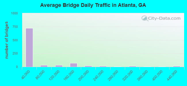
- 46,196,877Total average daily traffic
- 629,964Total average daily truck traffic
- National Bridge Inventory (NBI) Registered Bridges for Atlanta
- No street view available for this location
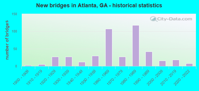
- New bridges - historical statistics
- 31900-1909
- 51910-1919
- 271920-1929
- 271930-1939
- 121940-1949
- 301950-1959
- 1071960-1969
- 271970-1979
- 1181980-1989
- 421990-1999
- 162000-2009
- 182010-2019
- 82020-2022
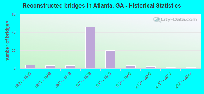
- Reconstructed bridges - Historical Statistics
- 41940-1949
- 31950-1959
- 31960-1969
- 461970-1979
- 201980-1989
- 31990-1999
- 22000-2009
- 12010-2019
- 12020-2022
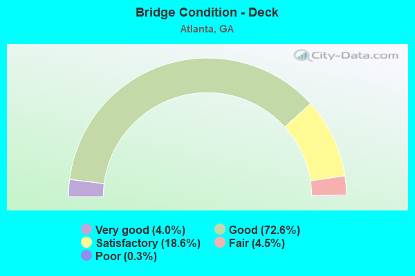
- Bridge Condition - Deck
- 4.0%Very good
- 72.6%Good
- 18.6%Satisfactory
- 4.5%Fair
- 0.3%Poor
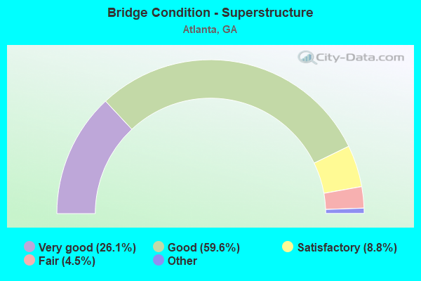
- Bridge Condition - Superstructure
- 26.1%Very good
- 59.6%Good
- 8.8%Satisfactory
- 4.5%Fair
- 1.1%Poor
- 0.3%Imminent failure
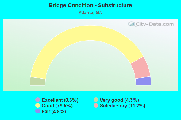
- Bridge Condition - Substructure
- 0.3%Excellent
- 4.3%Very good
- 79.5%Good
- 11.2%Satisfactory
- 4.8%Fair
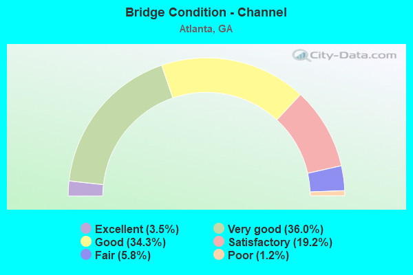
- Bridge Condition - Channel
- 3.5%Excellent
- 36.0%Very good
- 34.3%Good
- 19.2%Satisfactory
- 5.8%Fair
- 1.2%Poor
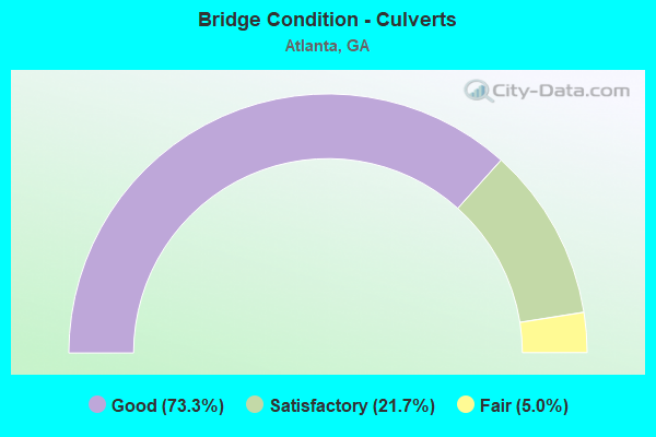
- Bridge Condition - Culverts
- 73.3%Good
- 21.7%Satisfactory
- 5.0%Fair
Find on map >> Show street view
Structure Number: 1215059, Location: 7 MI N OF FAIRBURN (Lat: 33.674700, Lng: -84.562208), Route carried "on" structure: County highway 498, Year Built: 1993, Status: Open, Structure Length: 6.10m (20.01ft), Average Daily Traffic: 1,900 (year 2008), Truck Traffic: 1%, Average Future Daily Traffic: 2,850 (year 2030), Design Load: HS 20+Mod, Features Intersected: CAMP CREEK, Facility Carried by Structure: MERK ROAD
Minimum Vertical Clearance: 30+ m (98+ ft), Kilometerpoint: 1.609, Lanes on structure: 2, Base Highway Network: Yes, Owner: City or Municipal Highway Agency, Approaching Roadway Width: 7.0m (23.0ft), Material/Design: Prestressed concrete, Design/Construction: Stringer/Multi-beam, Number Of Spans In Main Unit: 5, Length of Maximum Span: 12.2m (40.0ft), Curb-To-Curb Width: 8.5m (27.9ft), Out-to-Out Width: 9.5m (31.2ft)
Condition: Deck: Good, Superstructure: Very good, Substructure: Good, Channel: Good, Operating Rating: 45.3 metric tons, Method Used To Determine Operating Rating: Load Factor (LF), Inventory Rating: 23.5 metric tons, Method Used To Determine Inventory Rating: Load Factor (LF), Structural Evaluation: Equal to present minimum criteria, Deck Geometry: Somewhat better than minimum adequacy, Waterway Adequacy: Superior to present desirable criteria, Approach Roadway Alignment: Equal to present desirable criteria, Designated Inspection Frequency: Every 24 months, Inspection Date: July 2020, Bridge Improvement Cost: $781,000, Roadway Improvement Cost: $78,000, Total Project Cost: $1,172,000, Deck Structure Type: Concrete Cast-file-Place
Find on map >> Show street view
Structure Number: 121508, Location: 3 MI S OF FAIRBURN (Lat: 33.527450, Lng: -84.583050), Route carried "on" structure: County highway 628, Year Built: 1963, Status: Open, Structure Length: 1.83m (6.00ft), Average Daily Traffic: 1,940 (year 2011), Truck Traffic: 1%, Average Future Daily Traffic: 2,910 (year 2031), Design Load: H 15, Features Intersected: TRICKHAM CREEK, Facility Carried by Structure: LANDRUM ROAD
Minimum Vertical Clearance: 30+ m (98+ ft), Kilometerpoint: 0.000, Lanes on structure: 2, Base Highway Network: Yes, Owner: City or Municipal Highway Agency, Approaching Roadway Width: 6.1m (20.0ft), Material/Design: Prestressed concrete, Design/Construction: Channel Beam, Number Of Spans In Main Unit: 2, Length of Maximum Span: 9.1m (29.9ft), Curb or Sidewalk Widths: Left: 0.2m (0.7ft), Right: 0.2m (0.7ft), Curb-To-Curb Width: 7.0m (23.0ft), Out-to-Out Width: 7.4m (24.3ft)
Condition: Deck: Fair, Superstructure: Fair, Substructure: Good, Channel: Good, Operating Rating: 36.2 metric tons, Method Used To Determine Operating Rating: Load Factor (LF), Inventory Rating: 21.7 metric tons, Method Used To Determine Inventory Rating: Load Factor (LF), Structural Evaluation: Somewhat better than minimum adequacy, Deck Geometry: High priority of corrective action, Waterway Adequacy: Superior to present desirable criteria, Approach Roadway Alignment: Equal to present desirable criteria, Length Of Structure Improvement: 8.26m (27.10ft), Designated Inspection Frequency: Every 24 months, Inspection Date: October 2020, Bridge Improvement Cost: $234,000, Roadway Improvement Cost: $23,000, Total Project Cost: $352,000, Deck Structure Type: Concrete Precast Panels, Wearing Surface/Protective System: Wearing Surface: Bituminous
Find on map >> Show street view
Structure Number: 1215087, Location: IN ATLANTA (Lat: 33.786289, Lng: -84.363778), Route carried "on" structure: City street 641, Year Built: 1934, Status: Open, Structure Length: 0.91m (2.99ft), Average Daily Traffic: 1,940 (year 2011), Truck Traffic: 1%, Average Future Daily Traffic: 2,910 (year 2031), Design Load: H 15, Features Intersected: CLEAR CREEK, Facility Carried by Structure: BROOKRIDGE DRIVE
Minimum Vertical Clearance: 30+ m (98+ ft), Kilometerpoint: 0.000, Lanes on structure: 2, Base Highway Network: Yes, Owner: City or Municipal Highway Agency, Approaching Roadway Width: 7.3m (24.0ft), Material/Design: Concrete, Design/Construction: Arch - Deck, Number Of Spans In Main Unit: 1, Length of Maximum Span: 9.1m (29.9ft), Curb or Sidewalk Widths: Left: 2.1m (6.9ft), Right: 2.1m (6.9ft), Curb-To-Curb Width: 7.3m (24.0ft), Out-to-Out Width: 12.5m (41.0ft)
Condition: Deck: Good, Superstructure: Good, Substructure: Very good, Channel: Very good, Operating Rating: 37.1 metric tons, Method Used To Determine Operating Rating: Allowable Stress (AS), Inventory Rating: 20.8 metric tons, Method Used To Determine Inventory Rating: Allowable Stress (AS), Structural Evaluation: Somewhat better than minimum adequacy, Deck Geometry: Meets minimum limits, Waterway Adequacy: Superior to present desirable criteria, Approach Roadway Alignment: Equal to present desirable criteria, Length Of Structure Improvement: 41.48m (136.09ft), Designated Inspection Frequency: Every 24 months, Inspection Date: May 2020, Bridge Improvement Cost: $117,000, Roadway Improvement Cost: $12,000, Total Project Cost: $176,000, Deck Structure Type: Concrete Cast-file-Place, Wearing Surface/Protective System: Wearing Surface: Bituminous
Find on map >> Show street view
Structure Number: 1215088, Location: PIEDMONT PK RR717941E (Lat: 33.786258, Lng: -84.370969), Route carried "on" structure: City street 647, Year Built: 1916, Status: Open, Structure Length: 6.61m (21.69ft), Average Daily Traffic: 2,202 (year 2011), Truck Traffic: 1%, Average Future Daily Traffic: 3,303 (year 2031), Design Load: H 15, Features Intersected: PEDESTRIAN WALKWAY, Facility Carried by Structure: PARK DRIVE
Minimum Vertical Clearance: 30+ m (98+ ft), Kilometerpoint: 0.000, Lanes on structure: 2, Base Highway Network: Yes, Owner: City or Municipal Highway Agency, Approaching Roadway Width: 7.3m (24.0ft), Skew: 9 degrees, Material/Design: Concrete, Design/Construction: Arch - Deck, Number Of Spans In Main Unit: 1, Number Of Approach Spans: 4, Length of Maximum Span: 22.3m (73.2ft), Curb or Sidewalk Widths: Left: 2.1m (6.9ft), Right: 2.1m (6.9ft), Curb-To-Curb Width: 7.3m (24.0ft), Out-to-Out Width: 12.5m (41.0ft)
Condition: Deck: Satisfactory, Superstructure: Satisfactory, Substructure: Satisfactory, Channel: Very good, Operating Rating: 37.1 metric tons, Method Used To Determine Operating Rating: Load Factor (LF), Inventory Rating: 19.0 metric tons, Method Used To Determine Inventory Rating: Load Factor (LF), Structural Evaluation: Somewhat better than minimum adequacy, Deck Geometry: High priority of replacement, Approach Roadway Alignment: Equal to present desirable criteria, Length Of Structure Improvement: 46.85m (153.71ft), Designated Inspection Frequency: Every 24 months, Inspection Date: May 2020, Bridge Improvement Cost: $848,000, Roadway Improvement Cost: $85,000, Total Project Cost: $1,272,000, Deck Structure Type: Concrete Cast-file-Place, Wearing Surface/Protective System: Wearing Surface: Bituminous, Membrane: Built-up
Find on map >> Show street view
Structure Number: 1215094, Location: IN W ATLANTA (Lat: 33.776069, Lng: -84.437839), Route carried "on" structure: City street 794, Year Built: 1931, Status: Open, Structure Length: 1.10m (3.61ft), Average Daily Traffic: 1,940 (year 2011), Truck Traffic: 1%, Average Future Daily Traffic: 2,910 (year 2031), Features Intersected: PROCTOR CREEK, Facility Carried by Structure: FRANCIS PLACE
Minimum Vertical Clearance: 30+ m (98+ ft), Kilometerpoint: 0.000, Lanes on structure: 2, Base Highway Network: Yes, Owner: City or Municipal Highway Agency, Approaching Roadway Width: 7.3m (24.0ft), Material/Design: Steel, Design/Construction: Stringer/Multi-beam, Number Of Spans In Main Unit: 1, Length of Maximum Span: 11.0m (36.1ft), Curb-To-Curb Width: 7.3m (24.0ft), Out-to-Out Width: 7.9m (25.9ft)
Condition: Deck: Good, Superstructure: Satisfactory, Substructure: Satisfactory, Channel: Satisfactory, Operating Rating: 45.3 metric tons, Method Used To Determine Operating Rating: Load Factor (LF), Inventory Rating: 27.2 metric tons, Method Used To Determine Inventory Rating: Load Factor (LF), Structural Evaluation: Equal to present minimum criteria, Deck Geometry: Meets minimum limits, Waterway Adequacy: Superior to present desirable criteria, Approach Roadway Alignment: Equal to present minimum criteria, Length Of Structure Improvement: 41.33m (135.60ft), Designated Inspection Frequency: Every 24 months, Inspection Date: September 2020, Bridge Improvement Cost: $141,000, Roadway Improvement Cost: $14,000, Total Project Cost: $211,000, Deck Structure Type: Concrete Cast-file-Place, Wearing Surface/Protective System: Wearing Surface: Bituminous
Find on map >> Show street view
Structure Number: 1215095, Location: IN WEST ATLANTA (Lat: 33.775908, Lng: -84.440639), Route carried "on" structure: City street 795, Year Built: 1984, Status: Open, Structure Length: 3.78m (12.40ft), Average Daily Traffic: 1,940 (year 2011), Truck Traffic: 1%, Average Future Daily Traffic: 2,910 (year 2031), Design Load: HS 20+Mod, Features Intersected: PROCTOR CREEK, Facility Carried by Structure: HORTENSE WAY
Minimum Vertical Clearance: 30+ m (98+ ft), Kilometerpoint: 0.000, Lanes on structure: 2, Base Highway Network: Yes, Owner: City or Municipal Highway Agency, Approaching Roadway Width: 8.5m (27.9ft), Skew: 1 degrees, Material/Design: Steel, Design/Construction: Stringer/Multi-beam, Number Of Spans In Main Unit: 1, Length of Maximum Span: 37.8m (124.0ft), Curb or Sidewalk Widths: Left: 1.5m (4.9ft), Right: 1.5m (4.9ft), Curb-To-Curb Width: 8.5m (27.9ft), Out-to-Out Width: 12.3m (40.4ft)
Condition: Deck: Satisfactory, Superstructure: Good, Substructure: Good, Channel: Very good, Operating Rating: 46.2 metric tons, Method Used To Determine Operating Rating: Allowable Stress (AS), Inventory Rating: 32.6 metric tons, Method Used To Determine Inventory Rating: Allowable Stress (AS), Structural Evaluation: Better than present minimum criteria, Deck Geometry: Somewhat better than minimum adequacy, Waterway Adequacy: Superior to present desirable criteria, Approach Roadway Alignment: Equal to present minimum criteria, Designated Inspection Frequency: Every 24 months, Inspection Date: September 2020, Bridge Improvement Cost: $484,000, Roadway Improvement Cost: $48,000, Total Project Cost: $727,000, Deck Structure Type: Concrete Cast-file-Place
Find on map >> Show street view
Structure Number: 1215103, Location: 10.5 MI W OF ATLANTA (Lat: 33.743628, Lng: -84.568289), Route carried "on" structure: County highway 1277, Year Built: 1966, Status: Open, Structure Length: 4.57m (14.99ft), Average Daily Traffic: 1,940 (year 2011), Truck Traffic: 1%, Average Future Daily Traffic: 2,910 (year 2031), Design Load: H 15, Features Intersected: NORTH UTOY CREEK, Facility Carried by Structure: GREAT SOUTHWEST PY
Minimum Vertical Clearance: 30+ m (98+ ft), Kilometerpoint: 1.609, Lanes on structure: 2, Base Highway Network: Yes, Owner: County Highway Agency, Approaching Roadway Width: 15.8m (51.8ft), Material/Design: Prestressed concrete, Design/Construction: Channel Beam, Number Of Spans In Main Unit: 5, Length of Maximum Span: 9.1m (29.9ft), Curb or Sidewalk Widths: Left: 0.1m (0.3ft), Right: 0.1m (0.3ft), Curb-To-Curb Width: 15.8m (51.8ft), Out-to-Out Width: 16.5m (54.1ft)
Condition: Deck: Satisfactory, Superstructure: Satisfactory, Substructure: Satisfactory, Channel: Satisfactory, Operating Rating: 33.5 metric tons, Method Used To Determine Operating Rating: Allowable Stress (AS), Inventory Rating: 20.8 metric tons, Method Used To Determine Inventory Rating: Allowable Stress (AS), Structural Evaluation: Somewhat better than minimum adequacy, Deck Geometry: Superior to present desirable criteria, Waterway Adequacy: Superior to present desirable criteria, Approach Roadway Alignment: Equal to present desirable criteria, Designated Inspection Frequency: Every 24 months, Inspection Date: March 2020, Bridge Improvement Cost: $586,000, Roadway Improvement Cost: $59,000, Total Project Cost: $879,000, Deck Structure Type: Concrete Precast Panels, Wearing Surface/Protective System: Wearing Surface: Bituminous
Find on map >> Show street view
Structure Number: 1215115, Location: 3 MI SE OF ATLANTA (Lat: 33.717819, Lng: -84.353878), Route carried "on" structure: City street 1483, Year Built: 1932, Status: Posted for load, Structure Length: 1.28m (4.20ft), Average Daily Traffic: 1,940 (year 2011), Truck Traffic: 1%, Average Future Daily Traffic: 2,910 (year 2031), Features Intersected: INTRENCHMENT CREEK, Facility Carried by Structure: WOODLAND ROAD
Minimum Vertical Clearance: 30+ m (98+ ft), Kilometerpoint: 0.000, Lanes on structure: 2, Base Highway Network: Yes, Owner: City or Municipal Highway Agency, Approaching Roadway Width: 7.9m (25.9ft), Material/Design: Steel, Design/Construction: Stringer/Multi-beam, Number Of Spans In Main Unit: 1, Length of Maximum Span: 12.8m (42.0ft), Curb or Sidewalk Widths: Left: 0.2m (0.7ft), Right: 1.7m (5.6ft), Curb-To-Curb Width: 6.6m (21.7ft), Out-to-Out Width: 8.6m (28.2ft)
Condition: Deck: Satisfactory, Superstructure: Good, Substructure: Good, Channel: Good, Operating Rating: 20.8 metric tons, Method Used To Determine Operating Rating: Load Factor (LF), Inventory Rating: 12.7 metric tons, Method Used To Determine Inventory Rating: Load Factor (LF), Structural Evaluation: Meets minimum limits, Deck Geometry: High priority of replacement, Waterway Adequacy: Better than present minimum criteria, Approach Roadway Alignment: Equal to present desirable criteria, Bridge Posting: Required (Relationship of Operating Rating to Maximum Legal Load: 30.0 - 39.9% below), Length Of Structure Improvement: 7.71m (25.30ft), Designated Inspection Frequency: Every 24 months, Inspection Date: June 2020, Bridge Improvement Cost: $164,000, Roadway Improvement Cost: $16,000, Total Project Cost: $246,000, Deck Structure Type: Concrete Cast-file-Place, Wearing Surface/Protective System: Wearing Surface: Bituminous, Membrane: Built-up
Find on map >> Show street view
Structure Number: 121512, Location: 8 MI NW OF FAIRBURN (Lat: 33.677428, Lng: -84.641478), Route carried "on" structure: County highway 1529, Year Built: 1920, Status: Posted for load, Structure Length: 2.50m (8.20ft), Average Daily Traffic: 1,940 (year 2011), Truck Traffic: 1%, Average Future Daily Traffic: 2,910 (year 2031), Features Intersected: CAMP CREEK, Facility Carried by Structure: COCHRAN ROAD
Minimum Vertical Clearance: 30+ m (98+ ft), Kilometerpoint: 4.828, Lanes on structure: 2, Base Highway Network: Yes, Owner: City or Municipal Highway Agency, Approaching Roadway Width: 6.1m (20.0ft), Material/Design: Steel, Design/Construction: Stringer/Multi-beam, Number Of Spans In Main Unit: 2, Length of Maximum Span: 12.5m (41.0ft), Curb or Sidewalk Widths: Left: 0.2m (0.7ft), Right: 0.2m (0.7ft), Curb-To-Curb Width: 6.0m (19.7ft), Out-to-Out Width: 6.5m (21.3ft)
Condition: Deck: Fair, Superstructure: Satisfactory, Substructure: Good, Channel: Good, Operating Rating: 16.3 metric tons, Method Used To Determine Operating Rating: Load Factor (LF), Inventory Rating: 9.0 metric tons, Method Used To Determine Inventory Rating: Load Factor (LF), Structural Evaluation: High priority of replacement, Deck Geometry: High priority of replacement, Waterway Adequacy: Superior to present desirable criteria, Approach Roadway Alignment: Equal to present desirable criteria, Bridge Posting: Required (Relationship of Operating Rating to Maximum Legal Load: > 39.9% below), Length Of Structure Improvement: 42.67m (139.99ft), Designated Inspection Frequency: Every 24 months, Inspection Date: July 2020, Bridge Improvement Cost: $320,000, Roadway Improvement Cost: $32,000, Total Project Cost: $481,000, Deck Structure Type: Concrete Cast-file-Place
Find on map >> Show street view
Structure Number: 1215125, Location: IN NORTH ATLANTA (Lat: 33.865039, Lng: -84.379569), Route carried "on" structure: City street 2509, Year Built: 1938, Status: Posted for load, Structure Length: 0.79m (2.59ft), Average Daily Traffic: 1,940 (year 2011), Truck Traffic: 1%, Average Future Daily Traffic: 2,910 (year 2031), Features Intersected: NANCY CREEK TRIB., Facility Carried by Structure: LAKEMOORE DRIVE
Minimum Vertical Clearance: 30+ m (98+ ft), Kilometerpoint: 0.000, Lanes on structure: 2, Base Highway Network: Yes, Owner: City or Municipal Highway Agency, Approaching Roadway Width: 9.8m (32.2ft), Skew: 4 degrees, Material/Design: Steel, Design/Construction: Stringer/Multi-beam, Number Of Spans In Main Unit: 1, Length of Maximum Span: 7.9m (25.9ft), Curb or Sidewalk Widths: Left: 1.5m (4.9ft), Right: 1.5m (4.9ft), Curb-To-Curb Width: 9.8m (32.2ft), Out-to-Out Width: 13.7m (44.9ft)
Condition: Deck: Good, Superstructure: Satisfactory, Substructure: Fair, Channel: Good, Operating Rating: 28.1 metric tons, Method Used To Determine Operating Rating: Load Factor (LF), Inventory Rating: 17.2 metric tons, Method Used To Determine Inventory Rating: Load Factor (LF), Structural Evaluation: Meets minimum limits, Deck Geometry: Somewhat better than minimum adequacy, Waterway Adequacy: Better than present minimum criteria, Approach Roadway Alignment: Equal to present desirable criteria, Bridge Posting: Required (Relationship of Operating Rating to Maximum Legal Load: 20.0 - 29.9% below), Designated Inspection Frequency: Every 24 months, Underwater Inspection Frequency: Every 60 months, Inspection Date: March 2020, Underwater Inspection Date: August 2018, Bridge Improvement Cost: $102,000, Roadway Improvement Cost: $10,000, Total Project Cost: $152,000, Deck Structure Type: Concrete Cast-file-Place, Wearing Surface/Protective System: Wearing Surface: Bituminous, Membrane: Built-up
Find on map >> Show street view
Structure Number: 1215126, Location: IN N ATLANTA (Lat: 33.869239, Lng: -84.378658), Route carried "on" structure: City street 2518, Year Built: 1941, Status: Open, Structure Length: 2.44m (8.01ft), Average Daily Traffic: 1,940 (year 2011), Truck Traffic: 1%, Average Future Daily Traffic: 2,910 (year 2031), Design Load: H 15, Features Intersected: NANCY CREEK, Facility Carried by Structure: RICKENBACKER DR
Minimum Vertical Clearance: 30+ m (98+ ft), Kilometerpoint: 0.000, Lanes on structure: 2, Base Highway Network: Yes, Owner: City or Municipal Highway Agency, Approaching Roadway Width: 7.3m (24.0ft), Skew: 4 degrees, Material/Design: Steel, Design/Construction: Stringer/Multi-beam, Number Of Spans In Main Unit: 2, Length of Maximum Span: 12.2m (40.0ft), Curb or Sidewalk Widths: Left: 0.2m (0.7ft), Right: 0.2m (0.7ft), Curb-To-Curb Width: 7.2m (23.6ft), Out-to-Out Width: 7.9m (25.9ft)
Condition: Deck: Satisfactory, Superstructure: Good, Substructure: Good, Channel: Good, Operating Rating: 49.8 metric tons, Method Used To Determine Operating Rating: Load Factor (LF), Inventory Rating: 29.9 metric tons, Method Used To Determine Inventory Rating: Load Factor (LF), Structural Evaluation: Better than present minimum criteria, Deck Geometry: High priority of corrective action, Waterway Adequacy: Equal to present desirable criteria, Approach Roadway Alignment: Equal to present minimum criteria, Length Of Structure Improvement: 42.70m (140.09ft), Designated Inspection Frequency: Every 24 months, Inspection Date: April 2020, Bridge Improvement Cost: $313,000, Roadway Improvement Cost: $31,000, Total Project Cost: $469,000, Deck Structure Type: Concrete Cast-file-Place
Find on map >> Show street view
Structure Number: 1215128, Location: IN W ATLANTA CITY LIMIT (Lat: 33.717658, Lng: -84.484108), Route carried "on" structure: City street 2997, Year Built: 1920, Status: Open, Structure Length: 0.91m (2.99ft), Average Daily Traffic: 1,940 (year 2011), Truck Traffic: 1%, Average Future Daily Traffic: 2,910 (year 2031), Features Intersected: SOUTH UTOY CREEK, Facility Carried by Structure: HARBIN ROAD
Minimum Vertical Clearance: 30+ m (98+ ft), Kilometerpoint: 0.000, Lanes on structure: 2, Base Highway Network: Yes, Owner: City or Municipal Highway Agency, Approaching Roadway Width: 6.4m (21.0ft), Skew: 1 degrees, Material/Design: Concrete continuous, Design/Construction: Slab, Number Of Spans In Main Unit: 3, Length of Maximum Span: 3.0m (9.8ft), Curb-To-Curb Width: 8.6m (28.2ft), Out-to-Out Width: 10.4m (34.1ft)
Condition: Deck: Satisfactory, Superstructure: Satisfactory, Substructure: Fair, Channel: Fair, Operating Rating: 43.5 metric tons, Method Used To Determine Operating Rating: Load Factor (LF), Inventory Rating: 24.4 metric tons, Method Used To Determine Inventory Rating: Load Factor (LF), Structural Evaluation: Somewhat better than minimum adequacy, Deck Geometry: Somewhat better than minimum adequacy, Waterway Adequacy: Superior to present desirable criteria, Approach Roadway Alignment: Equal to present minimum criteria, Designated Inspection Frequency: Every 24 months, Inspection Date: October 2020, Bridge Improvement Cost: $117,000, Roadway Improvement Cost: $12,000, Total Project Cost: $176,000, Deck Structure Type: Concrete Cast-file-Place, Wearing Surface/Protective System: Wearing Surface: Bituminous, Membrane: Built-up
Find on map >> Show street view
Structure Number: 121513, Location: IN ROSWELL (Lat: 34.029589, Lng: -84.350547), Route carried "on" structure: City street 3114, Year Built: 1960, Status: Open, Structure Length: 2.74m (8.99ft), Average Daily Traffic: 1,940 (year 2011), Truck Traffic: 1%, Average Future Daily Traffic: 2,910 (year 2031), Design Load: H 15, Features Intersected: HOG WALLER CREEK, Facility Carried by Structure: CHARLES PLACE
Minimum Vertical Clearance: 30+ m (98+ ft), Kilometerpoint: 0.000, Lanes on structure: 2, Base Highway Network: Yes, Owner: City or Municipal Highway Agency, Approaching Roadway Width: 5.5m (18.0ft), Material/Design: Concrete, Design/Construction: Channel Beam, Number Of Spans In Main Unit: 3, Length of Maximum Span: 9.1m (29.9ft), Curb or Sidewalk Widths: Left: 0.2m (0.7ft), Right: 0.2m (0.7ft), Curb-To-Curb Width: 6.9m (22.6ft), Out-to-Out Width: 7.4m (24.3ft)
Condition: Deck: Good, Superstructure: Good, Substructure: Satisfactory, Channel: Good, Operating Rating: 33.5 metric tons, Method Used To Determine Operating Rating: Allowable Stress (AS), Inventory Rating: 20.8 metric tons, Method Used To Determine Inventory Rating: Allowable Stress (AS), Structural Evaluation: Somewhat better than minimum adequacy, Deck Geometry: High priority of corrective action, Waterway Adequacy: Better than present minimum criteria, Approach Roadway Alignment: Equal to present minimum criteria, Length Of Structure Improvement: 42.98m (141.01ft), Designated Inspection Frequency: Every 24 months, Inspection Date: July 2021, Bridge Improvement Cost: $352,000, Roadway Improvement Cost: $35,000, Total Project Cost: $527,000, Deck Structure Type: Concrete Precast Panels, Wearing Surface/Protective System: Wearing Surface: Bituminous
Find on map >> Show street view
Structure Number: 1215149, Location: IN N W ATLANTA (Lat: 33.800189, Lng: -84.442469), Route carried "on" structure: City street 77, Year Built: 1971, Status: Posted for load, Structure Length: 12.89m (42.29ft), Average Daily Traffic: 1,940 (year 2011), Truck Traffic: 1%, Average Future Daily Traffic: 2,910 (year 2031), Design Load: H 15, Features Intersected: CSX RR YARD (TILFORD), Facility Carried by Structure: MARIETTA ROAD
Minimum Vertical Clearance: 30+ m (98+ ft), Kilometerpoint: 1.609, Lanes on structure: 2, Base Highway Network: Yes, Owner: City or Municipal Highway Agency, Approaching Roadway Width: 9.1m (29.9ft), Material/Design: Prestressed concrete, Design/Construction: Box Beam or Girders - Multiple, Number Of Spans In Main Unit: 5, Length of Maximum Span: 29.0m (95.1ft), Curb or Sidewalk Widths: Left: 1.5m (4.9ft), Right: 1.5m (4.9ft), Curb-To-Curb Width: 7.5m (24.6ft), Out-to-Out Width: 11.2m (36.7ft)
Condition: Deck: Poor, Superstructure: Poor, Substructure: Fair, Operating Rating: 9.9 metric tons, Method Used To Determine Operating Rating: Field evaluation and documented engineering judgment, Inventory Rating: 5.4 metric tons, Method Used To Determine Inventory Rating: Field evaluation and documented engineering judgment, Structural Evaluation: High priority of corrective action, Deck Geometry: Meets minimum limits, Underclear: Meets minimum limits, Approach Roadway Alignment: Equal to present minimum criteria, Bridge Posting: Required (Relationship of Operating Rating to Maximum Legal Load: > 39.9% below), Length Of Structure Improvement: 53.13m (174.31ft), Designated Inspection Frequency: Every 24 months, Inspection Date: October 2020, Bridge Improvement Cost: $1,653,000, Roadway Improvement Cost: $165,000, Total Project Cost: $2,479,000, Deck Structure Type: Concrete Precast Panels, Wearing Surface/Protective System: Wearing Surface: Bituminous, Membrane: Built-up
Find on map >> Show street view
Structure Number: 1215154, Location: IN N W ATLANTA (Lat: 33.787639, Lng: -84.464269), Route carried "on" structure: City street 769, Year Built: 1925, Status: Closed, Structure Length: 0.82m (2.69ft), Average Daily Traffic: 1,940 (year 2011), Truck Traffic: 1%, Average Future Daily Traffic: 2,910 (year 2031), Features Intersected: PROCTOR CREEK TRIB, Facility Carried by Structure: LOTUS AVE.
Minimum Vertical Clearance: 30+ m (98+ ft), Kilometerpoint: 0.000, Lanes on structure: 2, Base Highway Network: Yes, Owner: City or Municipal Highway Agency, Approaching Roadway Width: 5.5m (18.0ft), Material/Design: Steel, Design/Construction: Stringer/Multi-beam, Number Of Spans In Main Unit: 1, Length of Maximum Span: 8.2m (26.9ft), Curb or Sidewalk Widths: Left: 0.2m (0.7ft), Right: 0.2m (0.7ft), Curb-To-Curb Width: 5.5m (18.0ft), Out-to-Out Width: 6.2m (20.3ft)
Condition: Deck: Satisfactory, Superstructure: Poor, Substructure: Good, Channel: Good, Operating Rating: 43.5 metric tons, Method Used To Determine Operating Rating: Field evaluation and documented engineering judgment, Inventory Rating: 26.3 metric tons, Method Used To Determine Inventory Rating: Field evaluation and documented engineering judgment, Structural Evaluation: Meets minimum limits, Waterway Adequacy: Superior to present desirable criteria, Approach Roadway Alignment: Meets minimum limits, Bridge Posting: Required (Relationship of Operating Rating to Maximum Legal Load: > 39.9% below), Length Of Structure Improvement: 41.09m (134.81ft), Designated Inspection Frequency: Every 24 months, Inspection Date: November 2020, Bridge Improvement Cost: $105,000, Roadway Improvement Cost: $11,000, Total Project Cost: $158,000, Deck Structure Type: Concrete Cast-file-Place
Find on map >> Show street view
Structure Number: 1215155, Location: IN N W ATLANTA (Lat: 33.788658, Lng: -84.466058), Route carried "on" structure: City street 782, Year Built: 1936, Status: Open, Structure Length: 0.73m (2.40ft), Average Daily Traffic: 1,940 (year 2011), Truck Traffic: 1%, Average Future Daily Traffic: 2,910 (year 2031), Design Load: H 15, Features Intersected: PROCTOR CREEK TRIB, Facility Carried by Structure: SPRING STREET
Minimum Vertical Clearance: 30+ m (98+ ft), Kilometerpoint: 0.000, Lanes on structure: 2, Base Highway Network: Yes, Owner: City or Municipal Highway Agency, Approaching Roadway Width: 6.1m (20.0ft), Skew: 3 degrees, Material/Design: Concrete, Design/Construction: Culvert, Number Of Spans In Main Unit: 2, Length of Maximum Span: 3.7m (12.1ft)
Condition: Channel: Good, Culverts: Fair, Operating Rating: 43.5 metric tons, Method Used To Determine Operating Rating: Field evaluation and documented engineering judgment, Inventory Rating: 24.4 metric tons, Method Used To Determine Inventory Rating: Field evaluation and documented engineering judgment, Structural Evaluation: Somewhat better than minimum adequacy, Waterway Adequacy: Superior to present desirable criteria, Approach Roadway Alignment: Equal to present minimum criteria, Length Of Structure Improvement: 41.15m (135.01ft), Designated Inspection Frequency: Every 24 months, Inspection Date: November 2020, Bridge Improvement Cost: $94,000, Roadway Improvement Cost: $9,000, Total Project Cost: $141,000
Find on map >> Show street view
Structure Number: 1215156, Location: IN SOUTHWEST ATLANTA (Lat: 33.699719, Lng: -84.451208), Route carried "on" structure: City street 1219, Year Built: 1966, Status: Open, Structure Length: 0.98m (3.22ft), Average Daily Traffic: 1,940 (year 2011), Truck Traffic: 1%, Average Future Daily Traffic: 2,910 (year 2031), Design Load: H 15, Features Intersected: SOUTH UTOY CREEK TRIB, Facility Carried by Structure: ALISON STREET
Minimum Vertical Clearance: 30+ m (98+ ft), Kilometerpoint: 0.000, Lanes on structure: 2, Base Highway Network: Yes, Owner: City or Municipal Highway Agency, Approaching Roadway Width: 9.8m (32.2ft), Material/Design: Concrete, Design/Construction: Culvert, Number Of Spans In Main Unit: 3, Length of Maximum Span: 3.0m (9.8ft)
Condition: Channel: Very good, Culverts: Good, Operating Rating: 43.5 metric tons, Method Used To Determine Operating Rating: Field evaluation and documented engineering judgment, Inventory Rating: 24.4 metric tons, Method Used To Determine Inventory Rating: Field evaluation and documented engineering judgment, Structural Evaluation: Equal to present minimum criteria, Waterway Adequacy: Superior to present desirable criteria, Approach Roadway Alignment: Equal to present desirable criteria, Designated Inspection Frequency: Every 24 months, Inspection Date: April 2020, Bridge Improvement Cost: $125,000, Roadway Improvement Cost: $13,000, Total Project Cost: $188,000
Find on map >> Show street view
Structure Number: 1215163, Location: IN ATLANTA (Lat: 33.752958, Lng: -84.389028), Route carried "on" structure: City street 2042, Year Built: 1927, Year Reconstructed: 1999, Status: Open, Structure Length: 20.27m (66.50ft), Average Daily Traffic: 1,940 (year 2011), Truck Traffic: 1%, Average Future Daily Traffic: 2,910 (year 2031), Design Load: H 15, Features Intersected: LOWER WALL ST PARKING LO, Facility Carried by Structure: WALL STREET
Minimum Vertical Clearance: 30+ m (98+ ft), Kilometerpoint: 0.000, Lanes on structure: 4, Base Highway Network: Yes, Owner: City or Municipal Highway Agency, Approaching Roadway Width: 10.7m (35.1ft), Material/Design: Steel continuous, Design/Construction: Stringer/Multi-beam, Number Of Spans In Main Unit: 8, Number Of Approach Spans: 12, Length of Maximum Span: 21.0m (68.9ft), Curb or Sidewalk Widths: Left: 2.1m (6.9ft), Right: 2.1m (6.9ft), Curb-To-Curb Width: 10.7m (35.1ft), Out-to-Out Width: 22.3m (73.2ft)
Condition: Deck: Good, Superstructure: Good, Substructure: Good, Operating Rating: 45.3 metric tons, Method Used To Determine Operating Rating: Allowable Stress (AS), Inventory Rating: 24.4 metric tons, Method Used To Determine Inventory Rating: Allowable Stress (AS), Structural Evaluation: Equal to present minimum criteria, Deck Geometry: High priority of replacement, Approach Roadway Alignment: Better than present minimum criteria, Length Of Structure Improvement: 28.35m (93.01ft), Designated Inspection Frequency: Every 24 months, Inspection Date: June 2020, Bridge Improvement Cost: $4,016,000, Roadway Improvement Cost: $402,000, Total Project Cost: $6,023,000, Deck Structure Type: Concrete Cast-file-Place, Wearing Surface/Protective System: Wearing Surface: Bituminous, Membrane: Built-up
Find on map >> Show street view
Structure Number: 121517, Location: IN SOUTHWEST ATLANTA (Lat: 33.668489, Lng: -84.385569), Route carried "on" structure: City street 3125, Year Built: 1950, Status: Open, Structure Length: 0.64m (2.10ft), Average Daily Traffic: 2,202 (year 2011), Truck Traffic: 1%, Average Future Daily Traffic: 3,303 (year 2031), Design Load: H 15, Features Intersected: SOUTH RIVER TRIB, Facility Carried by Structure: OAK DRIVE
Minimum Vertical Clearance: 30+ m (98+ ft), Kilometerpoint: 1.609, Lanes on structure: 2, Base Highway Network: Yes, Owner: City or Municipal Highway Agency, Approaching Roadway Width: 8.8m (28.9ft), Skew: 2 degrees, Material/Design: Concrete, Design/Construction: Culvert, Number Of Spans In Main Unit: 2, Length of Maximum Span: 3.0m (9.8ft)
Condition: Channel: Good, Culverts: Fair, Operating Rating: 41.7 metric tons, Method Used To Determine Operating Rating: Field evaluation and documented engineering judgment, Inventory Rating: 24.4 metric tons, Method Used To Determine Inventory Rating: Field evaluation and documented engineering judgment, Structural Evaluation: Somewhat better than minimum adequacy, Waterway Adequacy: Superior to present desirable criteria, Approach Roadway Alignment: Equal to present desirable criteria, Designated Inspection Frequency: Every 24 months, Inspection Date: June 2020, Bridge Improvement Cost: $82,000, Roadway Improvement Cost: $8,000, Total Project Cost: $123,000
Find on map >> Show street view
Structure Number: 1215172, Location: IN ATLANTA (Lat: 33.753678, Lng: -84.396528), Route carried "on" structure: City street 3470, Year Built: 1982, Status: Open, Structure Length: 12.74m (41.80ft), Average Daily Traffic: 1,940 (year 2011), Truck Traffic: 1%, Average Future Daily Traffic: 2,910 (year 2031), Design Load: HS 20+Mod, Features Intersected: PARKING LOT NS RR, Facility Carried by Structure: RICHARD RUSSELL
Minimum Vertical Clearance: 30+ m (98+ ft), Kilometerpoint: 0.000, Lanes on structure: 2, Base Highway Network: Yes, Owner: City or Municipal Highway Agency, Approaching Roadway Width: 13.4m (44.0ft), Skew: 9 degrees, Material/Design: Steel, Design/Construction: Stringer/Multi-beam, Number Of Spans In Main Unit: 6, Length of Maximum Span: 25.3m (83.0ft), Curb or Sidewalk Widths: Left: 2.1m (6.9ft), Right: 2.6m (8.5ft), Curb-To-Curb Width: 13.4m (44.0ft), Out-to-Out Width: 18.5m (60.7ft)
Condition: Deck: Good, Superstructure: Satisfactory, Substructure: Satisfactory, Operating Rating: 46.2 metric tons, Method Used To Determine Operating Rating: Allowable Stress (AS), Inventory Rating: 32.6 metric tons, Method Used To Determine Inventory Rating: Allowable Stress (AS), Structural Evaluation: Equal to present minimum criteria, Deck Geometry: Superior to present desirable criteria, Underclear: Better than present minimum criteria, Approach Roadway Alignment: Equal to present desirable criteria, Designated Inspection Frequency: Every 24 months, Critical Feature Inspection Frequency: Every 12 months, Inspection Date: March 2020, Critical Feature Inspection Date: March 2021, Bridge Improvement Cost: $1,633,000, Roadway Improvement Cost: $163,000, Total Project Cost: $2,450,000, Deck Structure Type: Concrete Cast-file-Place
Find on map >> Show street view
Structure Number: 1215175, Location: IN ATLANTA (Lat: 33.752897, Lng: -84.389778), Route carried "on" structure: City street 2044, Year Built: 1929, Status: Open, Structure Length: 22.13m (72.60ft), Average Daily Traffic: 1,940 (year 2011), Truck Traffic: 1%, Average Future Daily Traffic: 2,910 (year 2031), Design Load: H 15, Features Intersected: CSX RR (340311N), Facility Carried by Structure: PRYOR STREET
Minimum Vertical Clearance: 30+ m (98+ ft), Kilometerpoint: 0.000, Lanes on structure: 4, Base Highway Network: Yes, Owner: City or Municipal Highway Agency, Approaching Roadway Width: 17.1m (56.1ft), Material/Design: Steel, Design/Construction: Girder and Floorbeam System, Number Of Spans In Main Unit: 5, Number Of Approach Spans: 18, Length of Maximum Span: 16.5m (54.1ft), Curb or Sidewalk Widths: Left: 1.8m (5.9ft), Right: 1.8m (5.9ft), Curb-To-Curb Width: 13.6m (44.6ft), Out-to-Out Width: 19.4m (63.6ft)
Condition: Deck: Satisfactory, Superstructure: Satisfactory, Substructure: Satisfactory, Operating Rating: 47.1 metric tons, Method Used To Determine Operating Rating: Load Factor (LF), Inventory Rating: 21.7 metric tons, Method Used To Determine Inventory Rating: Load Factor (LF), Structural Evaluation: Somewhat better than minimum adequacy, Deck Geometry: High priority of replacement, Underclear: High priority of replacement, Approach Roadway Alignment: Better than present minimum criteria, Length Of Structure Improvement: 28.22m (92.59ft), Designated Inspection Frequency: Every 24 months, Critical Feature Inspection Frequency: Every 24 months, Inspection Date: April 2020, Critical Feature Inspection Date: April 2021, Bridge Improvement Cost: $4,384,000, Roadway Improvement Cost: $438,000, Total Project Cost: $6,576,000, Deck Structure Type: Concrete Cast-file-Place, Wearing Surface/Protective System: Wearing Surface: Bituminous, Membrane: Built-up
Find on map >> Show street view
Structure Number: 1215178, Location: IN N ATLANTA (Lat: 33.859778, Lng: -84.424508), Route carried "on" structure: City street 263, Year Built: 1928, Status: Open, Structure Length: 2.26m (7.41ft), Average Daily Traffic: 1,940 (year 2011), Truck Traffic: 1%, Average Future Daily Traffic: 2,910 (year 2031), Features Intersected: NANCY CREEK, Facility Carried by Structure: RANDALL MILL ROAD
Minimum Vertical Clearance: 30+ m (98+ ft), Kilometerpoint: 1.609, Lanes on structure: 2, Base Highway Network: Yes, Owner: City or Municipal Highway Agency, Approaching Roadway Width: 7.9m (25.9ft), Skew: 3 degrees, Material/Design: Steel, Design/Construction: Stringer/Multi-beam, Number Of Spans In Main Unit: 2, Length of Maximum Span: 11.3m (37.1ft), Curb or Sidewalk Widths: Left: 0.2m (0.7ft), Right: 0.2m (0.7ft), Curb-To-Curb Width: 8.1m (26.6ft), Out-to-Out Width: 8.9m (29.2ft)
Condition: Deck: Good, Superstructure: Good, Substructure: Good, Channel: Good, Operating Rating: 66.2 metric tons, Method Used To Determine Operating Rating: Load Factor (LF), Inventory Rating: 39.9 metric tons, Method Used To Determine Inventory Rating: Load Factor (LF), Structural Evaluation: Better than present minimum criteria, Deck Geometry: Meets minimum limits, Waterway Adequacy: Superior to present desirable criteria, Approach Roadway Alignment: Equal to present minimum criteria, Designated Inspection Frequency: Every 24 months, Inspection Date: March 2020, Bridge Improvement Cost: $289,000, Roadway Improvement Cost: $29,000, Total Project Cost: $434,000, Deck Structure Type: Concrete Cast-file-Place, Wearing Surface/Protective System: Wearing Surface: Bituminous, Membrane: Built-up
Find on map >> Show street view
Structure Number: 1215179, Location: IN N W ATLANTA (Lat: 33.792408, Lng: -84.452069), Route carried "on" structure: City street 747, Year Built: 1966, Status: Open, Structure Length: 1.16m (3.81ft), Average Daily Traffic: 1,940 (year 2011), Truck Traffic: 1%, Average Future Daily Traffic: 2,910 (year 2031), Design Load: H 15, Features Intersected: PROCTOR CREEK, Facility Carried by Structure: STANFORD DRIVE
Minimum Vertical Clearance: 30+ m (98+ ft), Kilometerpoint: 0.000, Lanes on structure: 2, Base Highway Network: Yes, Owner: City or Municipal Highway Agency, Approaching Roadway Width: 9.8m (32.2ft), Material/Design: Concrete, Design/Construction: Culvert, Number Of Spans In Main Unit: 3, Length of Maximum Span: 3.7m (12.1ft)
Condition: Channel: Good, Culverts: Good, Operating Rating: 43.5 metric tons, Method Used To Determine Operating Rating: Field evaluation and documented engineering judgment, Inventory Rating: 24.4 metric tons, Method Used To Determine Inventory Rating: Field evaluation and documented engineering judgment, Structural Evaluation: Equal to present minimum criteria, Waterway Adequacy: Superior to present desirable criteria, Approach Roadway Alignment: Better than present minimum criteria, Designated Inspection Frequency: Every 24 months, Inspection Date: October 2020, Bridge Improvement Cost: $148,000, Roadway Improvement Cost: $15,000, Total Project Cost: $223,000
Find on map >> Show street view
Structure Number: 121518, Location: IN ATLANTA (Lat: 33.770269, Lng: -84.457639), Route carried "on" structure: City street 9044, Year Built: 1966, Status: Open, Structure Length: 0.64m (2.10ft), Average Daily Traffic: 2,710 (year 2011), Truck Traffic: 1%, Average Future Daily Traffic: 4,065 (year 2031), Design Load: H 15, Features Intersected: PROCTOR CREEK TRIB, Facility Carried by Structure: BAKER ROAD
Minimum Vertical Clearance: 30+ m (98+ ft), Kilometerpoint: 1.609, Lanes on structure: 2, Base Highway Network: Yes, Owner: City or Municipal Highway Agency, Approaching Roadway Width: 8.8m (28.9ft), Material/Design: Concrete, Design/Construction: Culvert, Number Of Spans In Main Unit: 2, Length of Maximum Span: 3.0m (9.8ft), Curb or Sidewalk Widths: Left: 0.2m (0.7ft), Right: 0.2m (0.7ft)
Condition: Channel: Good, Culverts: Good, Operating Rating: 41.7 metric tons, Method Used To Determine Operating Rating: Field evaluation and documented engineering judgment, Inventory Rating: 24.4 metric tons, Method Used To Determine Inventory Rating: Field evaluation and documented engineering judgment, Structural Evaluation: Equal to present minimum criteria, Waterway Adequacy: Equal to present desirable criteria, Approach Roadway Alignment: Equal to present desirable criteria, Designated Inspection Frequency: Every 24 months, Inspection Date: September 2020, Bridge Improvement Cost: $82,000, Roadway Improvement Cost: $8,000, Total Project Cost: $123,000
Find on map >> Show street view
Structure Number: 1215192, Location: IN NORTH ATLANTA (Lat: 33.868200, Lng: -84.364958), Route carried "on" structure: City street 2490, Year Built: 1927, Status: Open, Structure Length: 0.91m (2.99ft), Average Daily Traffic: 1,940 (year 2011), Truck Traffic: 1%, Average Future Daily Traffic: 2,910 (year 2031), Design Load: H 15, Features Intersected: NANCY CREEK TRIB, Facility Carried by Structure: NORTH IVY ROAD
Minimum Vertical Clearance: 30+ m (98+ ft), Kilometerpoint: 0.000, Lanes on structure: 2, Base Highway Network: Yes, Owner: City or Municipal Highway Agency, Approaching Roadway Width: 9.1m (29.9ft), Skew: 1 degrees, Material/Design: Concrete, Design/Construction: Culvert, Number Of Spans In Main Unit: 2, Length of Maximum Span: 4.3m (14.1ft), Curb or Sidewalk Widths: Left: 0.2m (0.7ft), Right: 0.2m (0.7ft)
Condition: Channel: Good, Culverts: Good, Operating Rating: 43.5 metric tons, Method Used To Determine Operating Rating: Field evaluation and documented engineering judgment, Inventory Rating: 24.4 metric tons, Method Used To Determine Inventory Rating: Field evaluation and documented engineering judgment, Structural Evaluation: Equal to present minimum criteria, Waterway Adequacy: Superior to present desirable criteria, Approach Roadway Alignment: Better than present minimum criteria, Designated Inspection Frequency: Every 24 months, Inspection Date: March 2020, Bridge Improvement Cost: $117,000, Roadway Improvement Cost: $12,000, Total Project Cost: $176,000
Find on map >> Show street view
Structure Number: 1215193, Location: IN NORTH ATLANTA (Lat: 33.866847, Lng: -84.362608), Route carried "on" structure: City street 2490, Year Built: 1927, Status: Open, Structure Length: 0.85m (2.79ft), Average Daily Traffic: 1,940 (year 2011), Truck Traffic: 1%, Average Future Daily Traffic: 2,910 (year 2031), Design Load: H 15, Features Intersected: NANCY CREEK TRIB, Facility Carried by Structure: NORTH IVY ROAD
Minimum Vertical Clearance: 30+ m (98+ ft), Kilometerpoint: 1.609, Lanes on structure: 2, Base Highway Network: Yes, Owner: City or Municipal Highway Agency, Approaching Roadway Width: 8.5m (27.9ft), Material/Design: Concrete, Design/Construction: Culvert, Number Of Spans In Main Unit: 2, Length of Maximum Span: 4.3m (14.1ft), Curb-To-Curb Width: 8.5m (27.9ft), Out-to-Out Width: 11.9m (39.0ft)
Condition: Channel: Good, Culverts: Satisfactory, Operating Rating: 43.5 metric tons, Method Used To Determine Operating Rating: Field evaluation and documented engineering judgment, Inventory Rating: 24.4 metric tons, Method Used To Determine Inventory Rating: Field evaluation and documented engineering judgment, Structural Evaluation: Equal to present minimum criteria, Deck Geometry: Somewhat better than minimum adequacy, Waterway Adequacy: Superior to present desirable criteria, Approach Roadway Alignment: Equal to present desirable criteria, Designated Inspection Frequency: Every 24 months, Inspection Date: March 2020, Bridge Improvement Cost: $109,000, Roadway Improvement Cost: $11,000, Total Project Cost: $164,000
Find on map >> Show street view
Structure Number: 1215203, Location: IN BUCKHEAD (Lat: 33.819044, Lng: -84.370794), Route carried "on" structure: City street 482, Year Built: 1984, Status: Open, Structure Length: 2.62m (8.60ft), Average Daily Traffic: 1,900 (year 2007), Truck Traffic: 1%, Average Future Daily Traffic: 2,850 (year 2030), Design Load: HS 20+Mod, Features Intersected: MARTA, Facility Carried by Structure: GARSON DRIVE
Minimum Vertical Clearance: 30+ m (98+ ft), Kilometerpoint: 0.000, Lanes on structure: 2, Base Highway Network: Yes, Owner: City or Municipal Highway Agency, Approaching Roadway Width: 15.2m (49.9ft), Skew: 2 degrees, Material/Design: Prestressed concrete, Design/Construction: Stringer/Multi-beam, Number Of Spans In Main Unit: 1, Length of Maximum Span: 26.2m (86.0ft), Curb or Sidewalk Widths: Left: 0.3m (1.0ft), Right: 1.2m (3.9ft), Curb-To-Curb Width: 14.6m (47.9ft), Out-to-Out Width: 16.8m (55.1ft)
Condition: Deck: Good, Superstructure: Very good, Substructure: Very good, Operating Rating: 46.2 metric tons, Method Used To Determine Operating Rating: Allowable Stress (AS), Inventory Rating: 32.6 metric tons, Method Used To Determine Inventory Rating: Allowable Stress (AS), Structural Evaluation: Equal to present desirable criteria, Deck Geometry: Superior to present desirable criteria, Underclear: High priority of corrective action, Approach Roadway Alignment: Equal to present desirable criteria, Designated Inspection Frequency: Every 24 months, Inspection Date: June 2020, Bridge Improvement Cost: $336,000, Roadway Improvement Cost: $34,000, Total Project Cost: $504,000, Deck Structure Type: Concrete Cast-file-Place
Find on map >> Show street view
Structure Number: 1215206, Location: IN EAST POINT (Lat: 33.701378, Lng: -84.428200), Route carried "on" structure: City street 1194, Year Built: 1983, Status: Open, Structure Length: 4.39m (14.40ft), Average Daily Traffic: 1,940 (year 2011), Truck Traffic: 1%, Average Future Daily Traffic: 2,910 (year 2031), Design Load: HS 20+Mod, Features Intersected: CS 1191 ASTOR AVE., Facility Carried by Structure: MURPHY AVE.
Minimum Vertical Clearance: 30+ m (98+ ft), Kilometerpoint: 0.000, Lanes on structure: 2, Lanes under structure: 4, Base Highway Network: Yes, Owner: City or Municipal Highway Agency, Approaching Roadway Width: 10.7m (35.1ft), Material/Design: Steel, Design/Construction: Stringer/Multi-beam, Number Of Spans In Main Unit: 3, Length of Maximum Span: 23.8m (78.1ft), Curb or Sidewalk Widths: Left: 1.8m (5.9ft), Right: 1.8m (5.9ft), Curb-To-Curb Width: 11.0m (36.1ft), Out-to-Out Width: 15.3m (50.2ft)
Condition: Deck: Good, Superstructure: Good, Substructure: Good, Operating Rating: 46.2 metric tons, Method Used To Determine Operating Rating: Allowable Stress (AS), Inventory Rating: 32.6 metric tons, Method Used To Determine Inventory Rating: Allowable Stress (AS), Structural Evaluation: Better than present minimum criteria, Deck Geometry: Equal to present minimum criteria, Underclear: Equal to present minimum criteria, Approach Roadway Alignment: Equal to present desirable criteria, Designated Inspection Frequency: Every 24 months, Inspection Date: July 2020, Bridge Improvement Cost: $563,000, Roadway Improvement Cost: $56,000, Total Project Cost: $844,000, Deck Structure Type: Concrete Cast-file-Place
Find on map >> Show street view
Structure Number: 1215218, Location: IN ATLANTA (Lat: 33.705008, Lng: -84.412278), Route carried "on" structure: City street 1246, Year Built: 1946, Status: Open, Structure Length: 0.64m (2.10ft), Average Daily Traffic: 1,940 (year 2011), Truck Traffic: 1%, Average Future Daily Traffic: 2,910 (year 2031), Design Load: H 15, Features Intersected: SOUTH RIVER TRIB, Facility Carried by Structure: BREWER BLVD.
Minimum Vertical Clearance: 30+ m (98+ ft), Kilometerpoint: 1.609, Lanes on structure: 2, Base Highway Network: Yes, Owner: City or Municipal Highway Agency, Approaching Roadway Width: 12.2m (40.0ft), Material/Design: Concrete, Design/Construction: Culvert, Number Of Spans In Main Unit: 2, Length of Maximum Span: 3.0m (9.8ft)
Condition: Channel: Very good, Culverts: Good, Operating Rating: 43.5 metric tons, Method Used To Determine Operating Rating: Field evaluation and documented engineering judgment, Inventory Rating: 24.4 metric tons, Method Used To Determine Inventory Rating: Field evaluation and documented engineering judgment, Structural Evaluation: Equal to present minimum criteria, Waterway Adequacy: Superior to present desirable criteria, Approach Roadway Alignment: Better than present minimum criteria, Designated Inspection Frequency: Every 24 months, Inspection Date: September 2020, Bridge Improvement Cost: $82,000, Roadway Improvement Cost: $8,000, Total Project Cost: $123,000
Find on map >> Show street view
Structure Number: 1215226, Location: IN N ATLANTA (Lat: 33.806497, Lng: -84.433539), Route carried "on" structure: City street 56, Year Built: 1960, Status: Open, Structure Length: 0.67m (2.20ft), Average Daily Traffic: 1,940 (year 2011), Truck Traffic: 1%, Average Future Daily Traffic: 2,910 (year 2031), Design Load: H 15, Features Intersected: PEACHTREE CREEK TRIB, Facility Carried by Structure: LOGAN CIR. (NORTH)
Minimum Vertical Clearance: 30+ m (98+ ft), Kilometerpoint: 0.000, Lanes on structure: 2, Base Highway Network: Yes, Owner: City or Municipal Highway Agency, Approaching Roadway Width: 9.8m (32.2ft), Skew: 1 degrees, Material/Design: Concrete, Design/Construction: Culvert, Number Of Spans In Main Unit: 2, Length of Maximum Span: 3.0m (9.8ft)
Condition: Channel: Satisfactory, Culverts: Satisfactory, Structural Evaluation: Equal to present minimum criteria, Waterway Adequacy: Superior to present desirable criteria, Approach Roadway Alignment: Equal to present desirable criteria, Designated Inspection Frequency: Every 24 months, Inspection Date: October 2020, Bridge Improvement Cost: $86,000, Roadway Improvement Cost: $9,000, Total Project Cost: $129,000
Find on map >> Show street view
Structure Number: 1215227, Location: IN N ATLANTA (Lat: 33.805347, Lng: -84.432928), Route carried "on" structure: City street 56, Year Built: 1960, Status: Open, Structure Length: 0.73m (2.40ft), Average Daily Traffic: 1,940 (year 2011), Truck Traffic: 1%, Average Future Daily Traffic: 2,910 (year 2031), Design Load: H 15, Features Intersected: PEACHTREE CREEK TRIB, Facility Carried by Structure: LOGAN CIR. (SOUTH)
Minimum Vertical Clearance: 30+ m (98+ ft), Kilometerpoint: 1.609, Lanes on structure: 2, Base Highway Network: Yes, Owner: City or Municipal Highway Agency, Approaching Roadway Width: 9.8m (32.2ft), Skew: 3 degrees, Material/Design: Concrete, Design/Construction: Culvert, Number Of Spans In Main Unit: 2, Length of Maximum Span: 3.7m (12.1ft)
Condition: Channel: Good, Culverts: Good, Structural Evaluation: Better than present minimum criteria, Waterway Adequacy: Superior to present desirable criteria, Approach Roadway Alignment: Equal to present desirable criteria, Designated Inspection Frequency: Every 24 months, Inspection Date: October 2020, Bridge Improvement Cost: $94,000, Roadway Improvement Cost: $9,000, Total Project Cost: $141,000
Find on map >> Show street view
Structure Number: 1215228, Location: IN WEST ATLANTA (Lat: 33.774678, Lng: -84.426178), Route carried "on" structure: City street 716, Year Built: 1967, Status: Open, Structure Length: 2.38m (7.81ft), Average Daily Traffic: 1,940 (year 2011), Truck Traffic: 1%, Average Future Daily Traffic: 2,910 (year 2031), Design Load: HS 20, Features Intersected: CSX RAILROAD SPUR, Facility Carried by Structure: MARIETTA BLVD. NW
Minimum Vertical Clearance: 30+ m (98+ ft), Kilometerpoint: 1.609, Lanes on structure: 5, Base Highway Network: Yes, Owner: City or Municipal Highway Agency, Approaching Roadway Width: 15.8m (51.8ft), Skew: 3 degrees, Material/Design: Concrete, Design/Construction: Slab, Number Of Spans In Main Unit: 3, Length of Maximum Span: 9.1m (29.9ft), Curb or Sidewalk Widths: Left: 0.8m (2.6ft), Right: 0.8m (2.6ft), Curb-To-Curb Width: 17.1m (56.1ft), Out-to-Out Width: 19.2m (63.0ft)
Condition: Deck: Good, Superstructure: Good, Substructure: Good, Operating Rating: 51.7 metric tons, Method Used To Determine Operating Rating: Allowable Stress (AS), Inventory Rating: 32.6 metric tons, Method Used To Determine Inventory Rating: Allowable Stress (AS), Structural Evaluation: Better than present minimum criteria, Deck Geometry: High priority of replacement, Underclear: Meets minimum limits, Approach Roadway Alignment: Equal to present desirable criteria, Designated Inspection Frequency: Every 24 months, Inspection Date: June 2020, Bridge Improvement Cost: $554,000, Roadway Improvement Cost: $55,000, Total Project Cost: $831,000, Deck Structure Type: Concrete Cast-file-Place, Wearing Surface/Protective System: Wearing Surface: Epoxy Overlay
Find on map >> Show street view
Structure Number: 1215229, Location: IN ATLANTA (Lat: 33.714208, Lng: -84.397300), Route carried "on" structure: City street 1293, Year Built: 1958, Status: Open, Structure Length: 0.79m (2.59ft), Average Daily Traffic: 2,202 (year 2011), Truck Traffic: 1%, Average Future Daily Traffic: 3,303 (year 2031), Design Load: H 15, Features Intersected: SOUTH RIVER TRIB, Facility Carried by Structure: AUTHER LANGFORD RD
Minimum Vertical Clearance: 30+ m (98+ ft), Kilometerpoint: 0.000, Lanes on structure: 2, Base Highway Network: Yes, Owner: City or Municipal Highway Agency, Approaching Roadway Width: 7.6m (24.9ft), Skew: 2 degrees, Material/Design: Concrete, Design/Construction: Culvert, Number Of Spans In Main Unit: 3, Length of Maximum Span: 2.4m (7.9ft)
Condition: Channel: Satisfactory, Culverts: Good, Operating Rating: 41.7 metric tons, Method Used To Determine Operating Rating: Field evaluation and documented engineering judgment, Inventory Rating: 24.4 metric tons, Method Used To Determine Inventory Rating: Field evaluation and documented engineering judgment, Structural Evaluation: Equal to present minimum criteria, Waterway Adequacy: Superior to present desirable criteria, Approach Roadway Alignment: Better than present minimum criteria, Designated Inspection Frequency: Every 24 months, Inspection Date: September 2020, Bridge Improvement Cost: $102,000, Roadway Improvement Cost: $10,000, Total Project Cost: $152,000
Find on map >> Show street view
Structure Number: 121523, Location: IN ATLANTA (Lat: 33.711739, Lng: -84.395069), Route carried "on" structure: City street 1296, Year Built: 1955, Status: Open, Structure Length: 0.70m (2.30ft), Average Daily Traffic: 2,202 (year 2011), Truck Traffic: 1%, Average Future Daily Traffic: 3,303 (year 2031), Design Load: H 15, Features Intersected: SOUTH RIVER TRIB, Facility Carried by Structure: THORNTON STREET
Minimum Vertical Clearance: 30+ m (98+ ft), Kilometerpoint: 0.000, Lanes on structure: 2, Base Highway Network: Yes, Owner: City or Municipal Highway Agency, Approaching Roadway Width: 6.1m (20.0ft), Material/Design: Concrete, Design/Construction: Culvert, Number Of Spans In Main Unit: 3, Length of Maximum Span: 2.1m (6.9ft)
Condition: Channel: Fair, Culverts: Good, Operating Rating: 41.7 metric tons, Method Used To Determine Operating Rating: Field evaluation and documented engineering judgment, Inventory Rating: 24.4 metric tons, Method Used To Determine Inventory Rating: Field evaluation and documented engineering judgment, Structural Evaluation: Equal to present minimum criteria, Waterway Adequacy: Superior to present desirable criteria, Approach Roadway Alignment: Better than present minimum criteria, Designated Inspection Frequency: Every 24 months, Inspection Date: September 2020, Bridge Improvement Cost: $90,000, Roadway Improvement Cost: $9,000, Total Project Cost: $135,000
Find on map >> Show street view
Structure Number: 1215231, Location: IN SOUTH EAST ATLANTA (Lat: 33.697708, Lng: -84.359878), Route carried "on" structure: City street 1536, Year Built: 1960, Status: Posted for load, Structure Length: 4.02m (13.19ft), Average Daily Traffic: 2,530 (year 2011), Truck Traffic: 1%, Average Future Daily Traffic: 3,795 (year 2031), Design Load: H 15, Features Intersected: NS RAILROAD (718380W), Facility Carried by Structure: FORREST PARK RD
Minimum Vertical Clearance: 30+ m (98+ ft), Kilometerpoint: 3.219, Lanes on structure: 2, Base Highway Network: Yes, Owner: City or Municipal Highway Agency, Approaching Roadway Width: 9.8m (32.2ft), Skew: 1 degrees, Material/Design: Steel, Design/Construction: Stringer/Multi-beam, Number Of Spans In Main Unit: 3, Length of Maximum Span: 17.4m (57.1ft), Curb or Sidewalk Widths: Left: 1.4m (4.6ft), Right: 1.4m (4.6ft), Curb-To-Curb Width: 9.8m (32.2ft), Out-to-Out Width: 12.5m (41.0ft)
Condition: Deck: Satisfactory, Superstructure: Satisfactory, Substructure: Good, Operating Rating: 20.8 metric tons, Method Used To Determine Operating Rating: Load Factor (LF), Inventory Rating: 12.7 metric tons, Method Used To Determine Inventory Rating: Load Factor (LF), Structural Evaluation: Meets minimum limits, Deck Geometry: Meets minimum limits, Underclear: Somewhat better than minimum adequacy, Approach Roadway Alignment: Somewhat better than minimum adequacy, Bridge Posting: Required (Relationship of Operating Rating to Maximum Legal Load: 30.0 - 39.9% below), Designated Inspection Frequency: Every 24 months, Inspection Date: June 2020, Bridge Improvement Cost: $516,000, Roadway Improvement Cost: $52,000, Total Project Cost: $774,000, Deck Structure Type: Concrete Cast-file-Place
Find on map >> Show street view
Structure Number: 1215234, Location: IN NORTH ATLANTA (Lat: 33.866608, Lng: -84.361697), Route carried "on" structure: City street 2488, Year Built: 1955, Status: Open, Structure Length: 0.73m (2.40ft), Average Daily Traffic: 1,940 (year 2011), Truck Traffic: 1%, Average Future Daily Traffic: 2,910 (year 2031), Design Load: H 15, Features Intersected: NANCY CREEK TRIB, Facility Carried by Structure: N. STRATFORD ROAD
Minimum Vertical Clearance: 30+ m (98+ ft), Kilometerpoint: 0.000, Lanes on structure: 2, Base Highway Network: Yes, Owner: City or Municipal Highway Agency, Approaching Roadway Width: 9.1m (29.9ft), Skew: 3 degrees, Material/Design: Concrete, Design/Construction: Culvert, Number Of Spans In Main Unit: 2, Length of Maximum Span: 3.7m (12.1ft), Curb or Sidewalk Widths: Left: 3.2m (10.5ft), Right: 2.4m (7.9ft), Curb-To-Curb Width: 9.3m (30.5ft), Out-to-Out Width: 14.9m (48.9ft)
Condition: Channel: Good, Culverts: Good, Operating Rating: 43.5 metric tons, Method Used To Determine Operating Rating: Field evaluation and documented engineering judgment, Inventory Rating: 24.4 metric tons, Method Used To Determine Inventory Rating: Field evaluation and documented engineering judgment, Structural Evaluation: Equal to present minimum criteria, Deck Geometry: Somewhat better than minimum adequacy, Waterway Adequacy: Superior to present desirable criteria, Approach Roadway Alignment: Equal to present desirable criteria, Designated Inspection Frequency: Every 24 months, Inspection Date: March 2020, Bridge Improvement Cost: $94,000, Roadway Improvement Cost: $9,000, Total Project Cost: $141,000
Find on map >> Show street view
Structure Number: 1215235, Location: IN N ATLANTA (Lat: 33.869139, Lng: -84.369369), Route carried "on" structure: City street 2499, Year Built: 1955, Status: Posted for load, Structure Length: 0.76m (2.49ft), Average Daily Traffic: 1,940 (year 2011), Truck Traffic: 1%, Average Future Daily Traffic: 2,910 (year 2031), Features Intersected: NANCY CREEK TRIB., Facility Carried by Structure: MOUNTAIN WAY RD
Minimum Vertical Clearance: 30+ m (98+ ft), Kilometerpoint: 0.000, Lanes on structure: 2, Base Highway Network: Yes, Owner: City or Municipal Highway Agency, Approaching Roadway Width: 7.3m (24.0ft), Skew: 2 degrees, Material/Design: Steel, Design/Construction: Stringer/Multi-beam, Number Of Spans In Main Unit: 1, Length of Maximum Span: 7.6m (24.9ft), Curb or Sidewalk Widths: Left: 0.6m (2.0ft), Right: 0.6m (2.0ft), Curb-To-Curb Width: 7.3m (24.0ft), Out-to-Out Width: 8.5m (27.9ft)
Condition: Deck: Very good, Superstructure: Good, Substructure: Satisfactory, Channel: Good, Operating Rating: 31.7 metric tons, Method Used To Determine Operating Rating: Load Factor (LF), Inventory Rating: 19.0 metric tons, Method Used To Determine Inventory Rating: Load Factor (LF), Structural Evaluation: Somewhat better than minimum adequacy, Deck Geometry: Meets minimum limits, Waterway Adequacy: Better than present minimum criteria, Approach Roadway Alignment: Better than present minimum criteria, Bridge Posting: Required (Relationship of Operating Rating to Maximum Legal Load: 10.0 - 19.9% below), Designated Inspection Frequency: Every 24 months, Inspection Date: March 2020, Bridge Improvement Cost: $98,000, Roadway Improvement Cost: $10,000, Total Project Cost: $147,000, Deck Structure Type: Concrete Cast-file-Place, Wearing Surface/Protective System: Wearing Surface: Bituminous, Membrane: Built-up
Find on map >> Show street view
Structure Number: 1215236, Location: IN ATLANTA (Lat: 33.739047, Lng: -84.479189), Route carried "on" structure: City street 2822, Year Built: 1931, Status: Open, Structure Length: 0.76m (2.49ft), Average Daily Traffic: 1,940 (year 2011), Truck Traffic: 1%, Average Future Daily Traffic: 2,910 (year 2031), Features Intersected: NORTH UTOY CREEK, Facility Carried by Structure: PEYTON ROAD
Minimum Vertical Clearance: 30+ m (98+ ft), Kilometerpoint: 1.609, Lanes on structure: 2, Base Highway Network: Yes, Owner: City or Municipal Highway Agency, Approaching Roadway Width: 7.3m (24.0ft), Material/Design: Steel, Design/Construction: Stringer/Multi-beam, Number Of Spans In Main Unit: 1, Length of Maximum Span: 7.6m (24.9ft), Curb or Sidewalk Widths: Left: 0.3m (1.0ft), Right: 0.3m (1.0ft), Curb-To-Curb Width: 7.7m (25.3ft), Out-to-Out Width: 9.0m (29.5ft)
Condition: Deck: Good, Superstructure: Very good, Substructure: Satisfactory, Channel: Satisfactory, Operating Rating: 89.8 metric tons, Method Used To Determine Operating Rating: Load Factor (LF), Inventory Rating: 84.3 metric tons, Method Used To Determine Inventory Rating: Load Factor (LF), Structural Evaluation: Equal to present minimum criteria, Deck Geometry: Meets minimum limits, Waterway Adequacy: Superior to present desirable criteria, Approach Roadway Alignment: Equal to present minimum criteria, Designated Inspection Frequency: Every 24 months, Inspection Date: October 2020, Bridge Improvement Cost: $98,000, Roadway Improvement Cost: $10,000, Total Project Cost: $147,000, Deck Structure Type: Concrete Cast-file-Place, Wearing Surface/Protective System: Wearing Surface: Bituminous, Membrane: Built-up
Find on map >> Show street view
Structure Number: 1215239, Location: AT RICH'S DOWNTOWN (Lat: 33.753258, Lng: -84.394158), Route carried "on" structure: City street 9134, Year Built: 1996, Year Reconstructed: 2018, Status: Open, Structure Length: 10.30m (33.79ft), Average Daily Traffic: 5,840 (year 2011), Truck Traffic: 1%, Average Future Daily Traffic: 8,760 (year 2031), Features Intersected: PARKING LOT & RICH'S, Facility Carried by Structure: M.L.K. JR. DRIVE
Minimum Vertical Clearance: 30+ m (98+ ft), Kilometerpoint: 4.828, Lanes on structure: 2, Base Highway Network: Yes, Owner: City or Municipal Highway Agency, Approaching Roadway Width: 16.5m (54.1ft), Material/Design: Concrete continuous, Design/Construction: Stringer/Multi-beam, Number Of Spans In Main Unit: 4, Length of Maximum Span: 25.6m (84.0ft), Curb or Sidewalk Widths: Left: 0.0m, Right: 2.0m (6.6ft), Curb-To-Curb Width: 11.7m (38.4ft), Out-to-Out Width: 27.7m (90.9ft)
Condition: Deck: Good, Superstructure: Very good, Substructure: Satisfactory, Operating Rating: 56.2 metric tons, Method Used To Determine Operating Rating: Load Factor (LF), Inventory Rating: 19.0 metric tons, Method Used To Determine Inventory Rating: Load Factor (LF), Structural Evaluation: Meets minimum limits, Deck Geometry: Better than present minimum criteria, Approach Roadway Alignment: Somewhat better than minimum adequacy, Designated Inspection Frequency: Every 24 months, Inspection Date: January 2021, Bridge Improvement Cost: $1,321,000, Roadway Improvement Cost: $132,000, Total Project Cost: $1,981,000, Deck Structure Type: Concrete Cast-file-Place