Bridge Statistics for Atlanta, Georgia (GA)
Condition, Traffic, Stress, Structural Evaluation, Project Costs
- National Bridge Inventory (NBI) Statistics
- 943Number of bridges
- 11,804ft / 3,598mTotal length
- $2,063,749,000Total costs
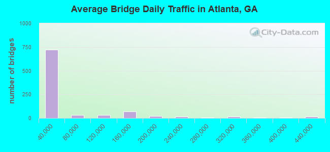
- 46,196,877Total average daily traffic
- 629,964Total average daily truck traffic
- National Bridge Inventory (NBI) Registered Bridges for Atlanta
- No street view available for this location
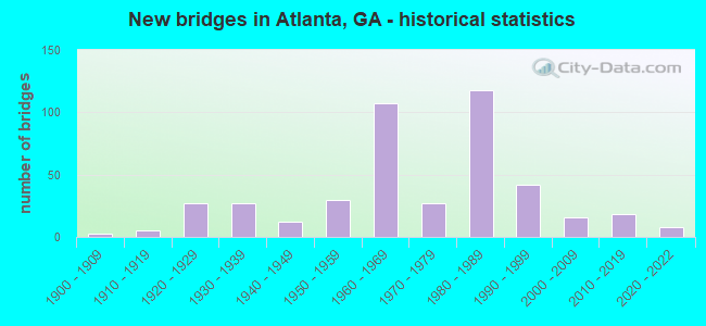
- New bridges - historical statistics
- 31900-1909
- 51910-1919
- 271920-1929
- 271930-1939
- 121940-1949
- 301950-1959
- 1071960-1969
- 271970-1979
- 1181980-1989
- 421990-1999
- 162000-2009
- 182010-2019
- 82020-2022
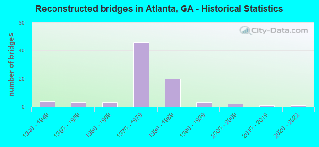
- Reconstructed bridges - Historical Statistics
- 41940-1949
- 31950-1959
- 31960-1969
- 461970-1979
- 201980-1989
- 31990-1999
- 22000-2009
- 12010-2019
- 12020-2022
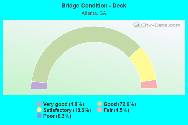
- Bridge Condition - Deck
- 4.0%Very good
- 72.6%Good
- 18.6%Satisfactory
- 4.5%Fair
- 0.3%Poor
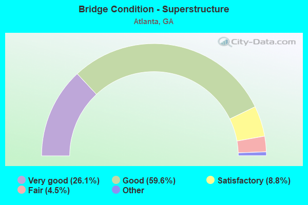
- Bridge Condition - Superstructure
- 26.1%Very good
- 59.6%Good
- 8.8%Satisfactory
- 4.5%Fair
- 1.1%Poor
- 0.3%Imminent failure
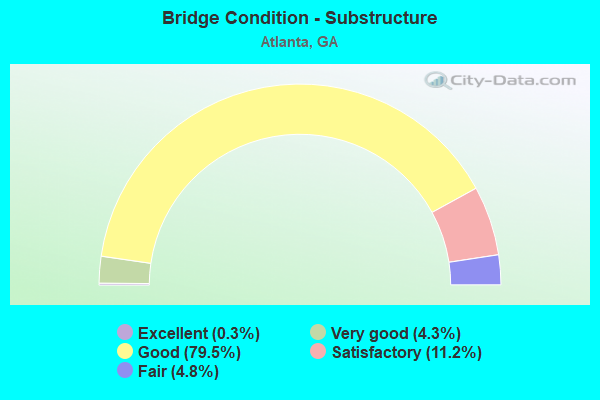
- Bridge Condition - Substructure
- 0.3%Excellent
- 4.3%Very good
- 79.5%Good
- 11.2%Satisfactory
- 4.8%Fair
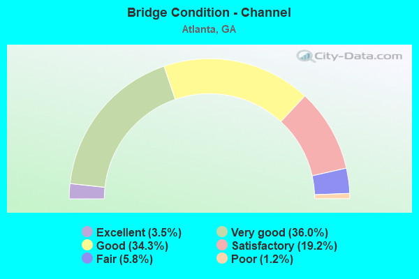
- Bridge Condition - Channel
- 3.5%Excellent
- 36.0%Very good
- 34.3%Good
- 19.2%Satisfactory
- 5.8%Fair
- 1.2%Poor
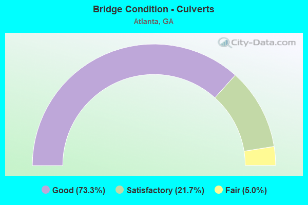
- Bridge Condition - Culverts
- 73.3%Good
- 21.7%Satisfactory
- 5.0%Fair
Find on map >> Show street view
Structure Number: 121538, Location: 1.9 MI W OF ALPHARETTA (Lat: 34.075519, Lng: -84.327608), Route carried "on" structure: County highway 9410, Year Built: 2018, Status: Open, Structure Length: 1.37m (4.49ft), Average Daily Traffic: 17,190 (year 2011), Truck Traffic: 1%, Average Future Daily Traffic: 25,785 (year 2031), Design Load: HS 20, Features Intersected: FOE KILLER CREEK, Facility Carried by Structure: RUCKER ROAD
Minimum Vertical Clearance: 30+ m (98+ ft), Kilometerpoint: 0.000, Lanes on structure: 2, Base Highway Network: Yes, Owner: City or Municipal Highway Agency, Approaching Roadway Width: 6.4m (21.0ft), Material/Design: Concrete, Design/Construction: Culvert, Number Of Spans In Main Unit: 1, Length of Maximum Span: 13.4m (44.0ft), Curb or Sidewalk Widths: Left: 2.4m (7.9ft), Right: 2.4m (7.9ft)
Condition: Channel: Satisfactory, Culverts: Good, Operating Rating: 40.8 metric tons, Method Used To Determine Operating Rating: Field evaluation and documented engineering judgment, Inventory Rating: 32.6 metric tons, Method Used To Determine Inventory Rating: Field evaluation and documented engineering judgment, Structural Evaluation: Better than present minimum criteria, Waterway Adequacy: Superior to present desirable criteria, Approach Roadway Alignment: Equal to present desirable criteria, Length Of Structure Improvement: 1.65m (5.41ft), Designated Inspection Frequency: Every 24 months, Inspection Date: August 2021, Bridge Improvement Cost: $3,996,000, Roadway Improvement Cost: $400,000, Total Project Cost: $5,994,000 ( Estimate for 2018)
Find on map >> Show street view
Structure Number: 1215386, Location: IN N W ATLANTA (Lat: 33.789508, Lng: -84.466272), Route carried "on" structure: City street 9042, Year Built: 1931, Status: Open, Structure Length: 0.67m (2.20ft), Average Daily Traffic: 2,890 (year 2011), Truck Traffic: 1%, Average Future Daily Traffic: 4,335 (year 2031), Design Load: H 15, Features Intersected: PROCTOR CREEK TRIB, Facility Carried by Structure: HOLLYWOOD ROAD
Minimum Vertical Clearance: 30+ m (98+ ft), Kilometerpoint: 1.609, Lanes on structure: 2, Base Highway Network: Yes, Owner: City or Municipal Highway Agency, Approaching Roadway Width: 9.1m (29.9ft), Skew: 3 degrees, Material/Design: Concrete, Design/Construction: Culvert, Number Of Spans In Main Unit: 2, Length of Maximum Span: 3.0m (9.8ft)
Condition: Channel: Very good, Culverts: Satisfactory, Operating Rating: 43.5 metric tons, Method Used To Determine Operating Rating: Field evaluation and documented engineering judgment, Inventory Rating: 24.4 metric tons, Method Used To Determine Inventory Rating: Field evaluation and documented engineering judgment, Structural Evaluation: Equal to present minimum criteria, Waterway Adequacy: Equal to present desirable criteria, Approach Roadway Alignment: Better than present minimum criteria, Length Of Structure Improvement: 0.79m (2.59ft), Designated Inspection Frequency: Every 24 months, Inspection Date: November 2020, Bridge Improvement Cost: $1,924,000, Roadway Improvement Cost: $192,000, Total Project Cost: $2,886,000 ( Estimate for 2019)
Find on map >> Show street view
Structure Number: 121539, Location: 1.4 MI N OF I-285 (Lat: 33.929828, Lng: -84.357828), Route carried "on" structure: City street 1318, Year Built: 2019, Status: Open, Structure Length: 13.42m (44.03ft), Average Daily Traffic: 5,410 (year 2011), Truck Traffic: 1%, Average Future Daily Traffic: 8,115 (year 2031), Design Load: HL 93, Features Intersected: SR 400 (US 19), Facility Carried by Structure: MT. VERNON HWY
Minimum Vertical Clearance: 30+ m (98+ ft), Kilometerpoint: 16.093, Lanes on structure: 4, Lanes under structure: 10, Base Highway Network: Yes, Owner: State Highway Agency, Approaching Roadway Width: 17.7m (58.1ft), Skew: 12 degrees, Material/Design: Prestressed concrete, Design/Construction: Stringer/Multi-beam, Number Of Spans In Main Unit: 4, Length of Maximum Span: 42.7m (140.1ft), Curb or Sidewalk Widths: Left: 3.0m (9.8ft), Right: 3.0m (9.8ft), Curb-To-Curb Width: 17.7m (58.1ft), Out-to-Out Width: 29.4m (96.5ft)
Condition: Deck: Good, Superstructure: Very good, Substructure: Very good, Operating Rating: 63.5 metric tons, Method Used To Determine Operating Rating: Load Factor (LF), Inventory Rating: 37.1 metric tons, Method Used To Determine Inventory Rating: Load Factor (LF), Structural Evaluation: Equal to present desirable criteria, Deck Geometry: Somewhat better than minimum adequacy, Underclear: Meets minimum limits, Approach Roadway Alignment: Better than present minimum criteria, Designated Inspection Frequency: Every 24 months, Inspection Date: April 2020, Deck Structure Type: Concrete Cast-file-Place
Find on map >> Show street view
Structure Number: 1215392, Location: IN N ATLANTA (Lat: 33.867758, Lng: -84.392897), Route carried "on" structure: County highway 9243, Year Built: 2019, Status: Open, Structure Length: 3.51m (11.52ft), Average Daily Traffic: 5,800 (year 2017), Truck Traffic: 1%, Average Future Daily Traffic: 7,100 (year 2037), Design Load: HL 93, Features Intersected: NANCY CREEK, Facility Carried by Structure: POWERS FERRY ROAD
Minimum Vertical Clearance: 30+ m (98+ ft), Kilometerpoint: 1.609, Lanes on structure: 2, Base Highway Network: Yes, Owner: City or Municipal Highway Agency, Approaching Roadway Width: 6.7m (22.0ft), Material/Design: Prestressed concrete, Design/Construction: Box Beam or Girders - Multiple, Number Of Spans In Main Unit: 1, Length of Maximum Span: 35.1m (115.2ft), Curb or Sidewalk Widths: Left: 1.8m (5.9ft), Right: 3.3m (10.8ft), Curb-To-Curb Width: 7.9m (25.9ft), Out-to-Out Width: 13.7m (44.9ft)
Condition: Deck: Very good, Superstructure: Very good, Substructure: Very good, Channel: Very good, Operating Rating: 87.9 metric tons, Method Used To Determine Operating Rating: Load Factor (LF), Inventory Rating: 31.7 metric tons, Method Used To Determine Inventory Rating: Load Factor (LF), Structural Evaluation: Better than present minimum criteria, Deck Geometry: High priority of replacement, Waterway Adequacy: Equal to present desirable criteria, Approach Roadway Alignment: Equal to present desirable criteria, Length Of Structure Improvement: 4.21m (13.81ft), Designated Inspection Frequency: Every 24 months, Inspection Date: April 2020, Bridge Improvement Cost: $10,212,000, Roadway Improvement Cost: $1,021,000, Total Project Cost: $15,318,000 ( Estimate for 2019), Deck Structure Type: Concrete Cast-file-Place, Wearing Surface/Protective System: Wearing Surface: Monolithic Concrete
Find on map >> Show street view
Structure Number: 1215398, Location: IN WEST ATLANTA (Lat: 33.715108, Lng: -84.490469), Route carried "on" structure: City street 2991, Year Built: 2020, Status: Open, Structure Length: 2.13m (6.99ft), Average Daily Traffic: 4,348 (year 2017), Truck Traffic: 1%, Average Future Daily Traffic: 5,305 (year 2037), Design Load: HS 20+Mod, Features Intersected: SOUTH UTOY CREEK, Facility Carried by Structure: CHILDRESS DRIVE
Minimum Vertical Clearance: 30+ m (98+ ft), Kilometerpoint: 6.437, Lanes on structure: 2, Base Highway Network: Yes, Owner: City or Municipal Highway Agency, Approaching Roadway Width: 6.1m (20.0ft), Skew: 3 degrees, Material/Design: Prestressed concrete, Design/Construction: Box Beam or Girders - Multiple, Number Of Spans In Main Unit: 1, Length of Maximum Span: 21.3m (69.9ft), Curb or Sidewalk Widths: Left: 1.8m (5.9ft), Right: 1.8m (5.9ft), Curb-To-Curb Width: 8.5m (27.9ft), Out-to-Out Width: 12.8m (42.0ft)
Condition: Deck: Very good, Superstructure: Good, Substructure: Excellent, Channel: Very good, Operating Rating: 59.8 metric tons, Method Used To Determine Operating Rating: Load Factor (LF), Inventory Rating: 27.2 metric tons, Method Used To Determine Inventory Rating: Load Factor (LF), Structural Evaluation: Equal to present minimum criteria, Deck Geometry: Meets minimum limits, Waterway Adequacy: Better than present minimum criteria, Approach Roadway Alignment: Equal to present desirable criteria, Length Of Structure Improvement: 2.56m (8.40ft), Designated Inspection Frequency: Every 24 months, Inspection Date: October 2020, Bridge Improvement Cost: $6,216,000, Roadway Improvement Cost: $622,000, Total Project Cost: $9,324,000 ( Estimate for 2020), Deck Structure Type: Concrete Cast-file-Place, Wearing Surface/Protective System: Wearing Surface: Bituminous
Find on map >> Show street view
Structure Number: 1215399, Location: SANDY SPRINGS (Lat: 33.912581, Lng: -84.356417), Route carried "on" structure: Ramp Interstate 400, Year Built: 2020, Status: Not yet open, Structure Length: 76.50m (250.98ft), Average Daily Traffic: 28,220 (year 2019), Truck Traffic: 6%, Average Future Daily Traffic: 2,039 (year 2039), Design Load: HL 93, Features Intersected: SR400, I-285
Minimum Vertical Clearance: 0.00m, Kilometerpoint: 12.875, Lanes on structure: 1, Lanes under structure: 20, Owner: State Highway Agency, Approaching Roadway Width: 9.1m (29.9ft), Material/Design: Prestressed concrete, Design/Construction: Stringer/Multi-beam, Number Of Spans In Main Unit: 22, Length of Maximum Span: 51.2m (168.0ft), Curb-To-Curb Width: 11.6m (38.1ft), Out-to-Out Width: 13.4m (44.0ft)
Condition: Deck: Very good, Superstructure: Good, Substructure: Good, Operating Rating: 34.4 metric tons, Method Used To Determine Operating Rating: Load Factor (LF), Inventory Rating: 20.8 metric tons, Method Used To Determine Inventory Rating: Load Factor (LF), Structural Evaluation: Somewhat better than minimum adequacy, Deck Geometry: Superior to present desirable criteria, Underclear: High priority of replacement, Approach Roadway Alignment: Equal to present desirable criteria, Length Of Structure Improvement: 91.81m (301.21ft), Designated Inspection Frequency: Every 24 months, Inspection Date: July 2020, Bridge Improvement Cost: $222,888,000, Roadway Improvement Cost: $22,289,000, Total Project Cost: $334,332,000 ( Estimate for 2020), Deck Structure Type: Concrete Cast-file-Place
Find on map >> Show street view
Structure Number: 1215401, Location: .3 MI E OF SR 54 (Lat: 33.717361, Lng: -84.379861), Route carried "on" structure: Spur State highway 42, Year Built: 2021, Status: Not yet open, Structure Length: 8.50m (27.89ft), Average Daily Traffic: 6,700 (year 2018), Truck Traffic: 9%, Average Future Daily Traffic: 8,300 (year 2038), Design Load: HL 93, Features Intersected: NORFOLK-SOUTHERN RR, Facility Carried by Structure: MCDONOUGH BLVD.
Minimum Vertical Clearance: 30+ m (98+ ft), Kilometerpoint: 0.000, Lanes on structure: 2, Base Highway Network: Yes, Owner: State Highway Agency, Approaching Roadway Width: 10.7m (35.1ft), Skew: 4 degrees, Material/Design: Prestressed concrete, Design/Construction: Stringer/Multi-beam, Number Of Spans In Main Unit: 3, Length of Maximum Span: 40.8m (133.9ft), Curb or Sidewalk Widths: Left: 1.7m (5.6ft), Right: 1.7m (5.6ft), Curb-To-Curb Width: 11.0m (36.1ft), Out-to-Out Width: 15.1m (49.5ft)
Condition: Deck: Very good, Superstructure: Very good, Substructure: Very good, Operating Rating: 87.0 metric tons, Method Used To Determine Operating Rating: Load Factor (LF), Inventory Rating: 43.5 metric tons, Method Used To Determine Inventory Rating: Load Factor (LF), Structural Evaluation: Equal to present desirable criteria, Deck Geometry: Meets minimum limits, Underclear: High priority of replacement, Approach Roadway Alignment: Better than present minimum criteria, Length Of Structure Improvement: 9.51m (31.20ft), Designated Inspection Frequency: Every 24 months, Inspection Date: March 2021, Bridge Improvement Cost: $23,088,000, Roadway Improvement Cost: $2,308,000, Total Project Cost: $34,632,000 ( Estimate for 2021), Deck Structure Type: Concrete Cast-file-Place, Wearing Surface/Protective System: Deck Protection: Epoxy Coated Reinforcing
Find on map >> Show street view
Structure Number: 1215409, Location: 9 MI W OF ATLANTA (Lat: 33.733647, Lng: -84.547519), Route carried "on" structure: City street 4176, Year Built: 2021, Status: Open, Structure Length: 1.25m (4.10ft), Average Daily Traffic: 6,590 (year 2011), Truck Traffic: 1%, Average Future Daily Traffic: 9,885 (year 2025), Design Load: HL 93, Features Intersected: BRANCH OF UTOY CREEK, Facility Carried by Structure: CASCADE ROAD
Minimum Vertical Clearance: 30+ m (98+ ft), Kilometerpoint: 2.269, Lanes on structure: 2, Base Highway Network: Yes, Owner: City or Municipal Highway Agency, Approaching Roadway Width: 9.4m (30.8ft), Skew: 1 degrees, Material/Design: Concrete, Design/Construction: Culvert, Number Of Spans In Main Unit: 1, Length of Maximum Span: 12.5m (41.0ft), Curb or Sidewalk Widths: Left: 4.1m (13.5ft), Right: 4.1m (13.5ft), Curb-To-Curb Width: 9.4m (30.8ft), Out-to-Out Width: 26.9m (88.3ft)
Condition: Channel: Very good, Culverts: Good, Operating Rating: 54.4 metric tons, Method Used To Determine Operating Rating: Field evaluation and documented engineering judgment, Inventory Rating: 32.6 metric tons, Method Used To Determine Inventory Rating: Field evaluation and documented engineering judgment, Structural Evaluation: Better than present minimum criteria, Deck Geometry: High priority of corrective action, Waterway Adequacy: Better than present minimum criteria, Approach Roadway Alignment: Equal to present desirable criteria, Designated Inspection Frequency: Every 24 months, Inspection Date: July 2021
Find on map >> Show street view
Structure Number: 630056, Location: ATLANTA AIRPORT (Lat: 33.641892, Lng: -84.449661), Route carried "under" structure: City street 1911, Structure Length: 0. m, Average Daily Traffic: 10,500 (year 2009), Truck Traffic: 1%, Features Intersected: M-1910 AIRPORT ROAD, Facility Carried by Structure: AIRPORT ROAD
Minimum Vertical Clearance: 5.58m (18.31ft), Kilometerpoint: 1.609, Lanes on structure: 8, Length of Maximum Span: 0.0m
Find on map >> Show street view
Structure Number: 63006, Location: ATLANTA AIRPORT (Lat: 33.646108, Lng: -84.445208), Route carried "under" structure: City street 1912, Structure Length: 0. m, Average Daily Traffic: 8,100 (year 2010), Truck Traffic: 1%, Features Intersected: M-1911 AIRPORT ROAD, Facility Carried by Structure: AIRPORT ROAD
Minimum Vertical Clearance: 5.15m (16.90ft), Kilometerpoint: 1.609, Lanes on structure: 1, Length of Maximum Span: 0.0m
Find on map >> Show street view
Structure Number: 630061, Location: ATLANTA AIRPORT (Lat: 33.644072, Lng: -84.447308), Route carried "under" structure: City street 1910, Structure Length: 0. m, Average Daily Traffic: 13,690 (year 2010), Truck Traffic: 1%, Features Intersected: M-1913 AIRPORT ROAD, Facility Carried by Structure: AIRPORT ROAD
Minimum Vertical Clearance: 5.46m (17.91ft), Kilometerpoint: 1.609, Lanes on structure: 2, Length of Maximum Span: 0.0m
Find on map >> Show street view
Structure Number: 630061, Location: ATLANTA AIRPORT (Lat: 33.644072, Lng: -84.447308), Route carried "under" structure: City street 1912, Structure Length: 0. m, Average Daily Traffic: 7,200 (year 1994), Truck Traffic: 1%, Features Intersected: M-1913 AIRPORT ROAD, Facility Carried by Structure: AIRPORT ROAD
Minimum Vertical Clearance: 5.10m (16.73ft), Kilometerpoint: 0.000, Lanes on structure: 2, Length of Maximum Span: 0.0m
Find on map >> Show street view
Structure Number: 670176, Location: 5.3 MILES SOUTH EAST OF S (Lat: 33.827708, Lng: -84.459400), Route carried "under" structure: City street 9003, Structure Length: 0. m, Average Daily Traffic: 22,520 (year 2012), Truck Traffic: 1%, Features Intersected: M-9003 ATLANTA ROAD, Facility Carried by Structure: CSX RR (639135A)
Minimum Vertical Clearance: 4.47m (14.67ft), Kilometerpoint: 0.000, Length of Maximum Span: 0.0m
Find on map >> Show street view
Structure Number: 675146, Location: 5.5 MILES SOUTH EAST OF S (Lat: 33.814489, Lng: -84.489978), Route carried "under" structure: County highway 1971, Structure Length: 0. m, Average Daily Traffic: 1,930 (year 2012), Truck Traffic: 1%, Features Intersected: CR 1971 RIVERVIEW ROAD, Facility Carried by Structure: NOR SOUTHERN RR (7
Minimum Vertical Clearance: 7.87m (25.82ft), Kilometerpoint: 3.219, Length of Maximum Span: 0.0m
Find on map >> Show street view
Structure Number: 675147, Location: 5 MI SE OF SMYRNA (Lat: 33.828469, Lng: -84.460700), Route carried "under" structure: County highway 1985, Structure Length: 0. m, Average Daily Traffic: 1,930 (year 2012), Truck Traffic: 1%, Features Intersected: CR 1985 NIFDA DRIVE, Facility Carried by Structure: CSX RR (639136G)
Minimum Vertical Clearance: 5.18m (16.99ft), Kilometerpoint: 0.000, Length of Maximum Span: 0.0m
Find on map >> Show street view
Structure Number: 890022, Location: 12 MI SW OF DECATUR (Lat: 33.667908, Lng: -84.340328), Route carried "under" structure: Interstate 285, Structure Length: 0. m, Average Daily Traffic: 115,000 (year 1999), Truck Traffic: 1%, Features Intersected: SR 42 MORELAND AVE., Facility Carried by Structure: MORELAND AVE.US 23
Minimum Vertical Clearance: 5.13m (16.83ft), Kilometerpoint: 85.295, Lanes on structure: 8, Length of Maximum Span: 0.0m
Find on map >> Show street view
Structure Number: 890105, Location: 9.5 MI S OF DECATUR (Lat: 33.671019, Lng: -84.332847), Route carried "under" structure: County highway 142, Structure Length: 0. m, Average Daily Traffic: 1,820 (year 1999), Truck Traffic: 1%, Features Intersected: I-285 (SR 407), Facility Carried by Structure: I-285
Minimum Vertical Clearance: 5.02m (16.47ft), Kilometerpoint: 0.000, Lanes on structure: 9, Length of Maximum Span: 0.0m
Find on map >> Show street view
Structure Number: 890164, Location: DEKALB-FULTON C/L IN ATL (Lat: 33.760094, Lng: -84.349164), Route carried "under" structure: US 23, Structure Length: 0. m, Average Daily Traffic: 27,900 (year 1999), Truck Traffic: 1%, Features Intersected: M-9332 DEKALB AVE., Facility Carried by Structure: DEKALB AVE-GA RR
Minimum Vertical Clearance: 4.74m (15.55ft), Kilometerpoint: 12.875, Lanes on structure: 5, Length of Maximum Span: 0.0m
Find on map >> Show street view
Structure Number: 890243, Location: 2.7 MI W OF DECATUR (Lat: 33.761389, Lng: -84.341847), Route carried "under" structure: City street 9193, Structure Length: 0. m, Average Daily Traffic: 6,140 (year 2011), Truck Traffic: 2%, Features Intersected: M-9193 WHITEFOORD AVE., Facility Carried by Structure: CSX RAILROAD
Minimum Vertical Clearance: 5.02m (16.47ft), Kilometerpoint: 1.609, Length of Maximum Span: 0.0m
Find on map >> Show street view
Structure Number: 890281, Location: 5.5 MI S OF DECATUR (Lat: 33.671533, Lng: -84.333800), Route carried "under" structure: City street 142, Structure Length: 0. m, Average Daily Traffic: 1,820 (year 1999), Truck Traffic: 1%, Features Intersected: I-285 RMP TO MORELAND, Facility Carried by Structure: I-285R TO MORELAND
Minimum Vertical Clearance: 5.00m (16.40ft), Kilometerpoint: 0.000, Lanes on structure: 1, Length of Maximum Span: 0.0m
Find on map >> Show street view
Structure Number: 890284, Location: 7 MI S OF DECATUR (Lat: 33.670292, Lng: -84.332003), Route carried "under" structure: County highway 142, Structure Length: 0. m, Average Daily Traffic: 1,820 (year 1999), Truck Traffic: 1%, Features Intersected: I-285 E. RMP TO I-675 SB, Facility Carried by Structure: I-285 EAST RAMP TO
Minimum Vertical Clearance: 6.37m (20.90ft), Kilometerpoint: 1.609, Lanes on structure: 2, Length of Maximum Span: 0.0m
Find on map >> Show street view
Structure Number: 890285, Location: 7 MI S OF DECATUR (Lat: 33.669539, Lng: -84.334819), Route carried "under" structure: Ramp State highway 42, Structure Length: 0. m, Average Daily Traffic: 3,001 (year 2009), Truck Traffic: 1%, Features Intersected: I-285 RAMP TO I-675 SBL, Facility Carried by Structure: I-285R TO I-675 SB
Minimum Vertical Clearance: 5.48m (17.98ft), Kilometerpoint: 1.609, Lanes on structure: 1, Length of Maximum Span: 0.0m
Find on map >> Show street view
Structure Number: 890293, Location: 5 MI S OF DECATUR (Lat: 33.671469, Lng: -84.334000), Route carried "under" structure: Ramp Interstate 285, Structure Length: 0. m, Average Daily Traffic: 3,500 (year 2009), Truck Traffic: 1%, Features Intersected: I675R TO I285 WB & CR 14
Minimum Vertical Clearance: 5.05m (16.57ft), Kilometerpoint: 83.686, Lanes on structure: 2, Length of Maximum Span: 0.0m
Find on map >> Show street view
Structure Number: 8903, Location: 2.6 MI W OF DECATUR (Lat: 33.762158, Lng: -84.340078), Route carried "under" structure: City street 9332, Structure Length: 0. m, Average Daily Traffic: 18,060 (year 2011), Truck Traffic: 3%, Features Intersected: M-9332 DEKALB AVE., Facility Carried by Structure: MARTA PED O/PASS
Minimum Vertical Clearance: 8.33m (27.33ft), Kilometerpoint: 0.000, Length of Maximum Span: 0.0m
Find on map >> Show street view
Structure Number: 890301, Location: 2.7 MI W OF DECATUR (Lat: 33.761528, Lng: -84.341828), Route carried "under" structure: City street 9193, Structure Length: 0. m, Average Daily Traffic: 6,140 (year 2011), Truck Traffic: 2%, Features Intersected: M 9193 WHITEFOORD AVE, Facility Carried by Structure: MARTA
Minimum Vertical Clearance: 6.40m (21.00ft), Kilometerpoint: 1.609, Length of Maximum Span: 0.0m
Find on map >> Show street view
Structure Number: 890302, Location: 2.7 MI W OF DECATUR (Lat: 33.761650, Lng: -84.341842), Route carried "under" structure: City street 9193, Structure Length: 0. m, Average Daily Traffic: 6,140 (year 2011), Truck Traffic: 2%, Features Intersected: M 9193 WHITEFOORD AVE, Facility Carried by Structure: MARTA
Minimum Vertical Clearance: 6.29m (20.64ft), Kilometerpoint: 1.609, Length of Maximum Span: 0.0m
Find on map >> Show street view
Structure Number: 890308, Location: 5 MI SW OF DECATUR (Lat: 33.745481, Lng: -84.349236), Route carried "under" structure: Interstate 20, Structure Length: 0. m, Average Daily Traffic: 152,600 (year 1999), Truck Traffic: 1%, Features Intersected: SR 42 MORELAND AVE., Facility Carried by Structure: MORELAND AVE.
Minimum Vertical Clearance: 5.43m (17.81ft), Kilometerpoint: 94.951, Lanes on structure: 7, Length of Maximum Span: 0.0m
Find on map >> Show street view
Structure Number: 89031, Location: 2.8 MI SW OF DECATUR (Lat: 33.739853, Lng: -84.328419), Route carried "under" structure: Interstate 20, Structure Length: 0. m, Average Daily Traffic: 138,800 (year 1999), Truck Traffic: 1%, Features Intersected: SR 260 GLENWOOD AVE., Facility Carried by Structure: GLENWOOD AVE.
Minimum Vertical Clearance: 5.61m (18.41ft), Kilometerpoint: 98.170, Lanes on structure: 6, Length of Maximum Span: 0.0m
Find on map >> Show street view
Structure Number: 890314, Location: IN ATLANTA (Lat: 33.726808, Lng: -84.323947), Route carried "under" structure: Interstate 20, Structure Length: 0. m, Average Daily Traffic: 131,600 (year 1999), Truck Traffic: 1%, Features Intersected: M-9122 FLAT SHOALS ROAD, Facility Carried by Structure: FLAT SHOAL ROAD
Minimum Vertical Clearance: 6.70m (21.98ft), Kilometerpoint: 99.779, Lanes on structure: 4, Length of Maximum Span: 0.0m
Find on map >> Show street view
Structure Number: 890316, Location: IN ATLANTA (Lat: 33.725200, Lng: -84.324100), Route carried "under" structure: Interstate 20, Structure Length: 0. m, Average Daily Traffic: 131,600 (year 1999), Truck Traffic: 1%, Features Intersected: M-9174 FAYETTEVILLE ROAD, Facility Carried by Structure: FAYETTEVILLE ROAD
Minimum Vertical Clearance: 8.22m (26.97ft), Kilometerpoint: 99.779, Lanes on structure: 2, Length of Maximum Span: 0.0m
Find on map >> Show street view
Structure Number: 890317, Location: IN ATLANTA (Lat: 33.744653, Lng: -84.334303), Route carried "under" structure: Interstate 20, Structure Length: 0. m, Average Daily Traffic: 139,400 (year 1999), Truck Traffic: 1%, Features Intersected: M-9194 MAYNARD TERR., Facility Carried by Structure: MAYNARD TERR.
Minimum Vertical Clearance: 7.08m (23.23ft), Kilometerpoint: 96.561, Lanes on structure: 3, Length of Maximum Span: 0.0m
Find on map >> Show street view
Structure Number: 89032, Location: IN ATLANTA (Lat: 33.743458, Lng: -84.332128), Route carried "under" structure: Interstate 20, Structure Length: 0. m, Average Daily Traffic: 139,400 (year 1999), Truck Traffic: 1%, Features Intersected: CS 2631 CLIFTON STREET, Facility Carried by Structure: CLIFTON STREET
Minimum Vertical Clearance: 7.69m (25.23ft), Kilometerpoint: 96.561, Lanes on structure: 2, Length of Maximum Span: 0.0m
Find on map >> Show street view
Structure Number: 895113, Location: 2 MI W OF DECATUR (Lat: 33.761069, Lng: -84.331089), Route carried "under" structure: City street 2685, Structure Length: 0. m, Average Daily Traffic: 2,202 (year 2011), Truck Traffic: 1%, Features Intersected: CR 2685 ARIZONA AVE., Facility Carried by Structure: CSX RAILROAD
Minimum Vertical Clearance: 4.95m (16.24ft), Kilometerpoint: 0.000, Length of Maximum Span: 0.0m
Find on map >> Show street view
Structure Number: 895114, Location: 2 MI W OF DECATUR (Lat: 33.761189, Lng: -84.331069), Route carried "under" structure: City street 2685, Structure Length: 0. m, Average Daily Traffic: 2,202 (year 2011), Truck Traffic: 1%, Features Intersected: CR 2685 ARIZONA AVE., Facility Carried by Structure: MARTA
Minimum Vertical Clearance: 5.00m (16.40ft), Kilometerpoint: 0.000, Length of Maximum Span: 0.0m
Find on map >> Show street view
Structure Number: 895115, Location: 2 MI W OF DECATUR (Lat: 33.761269, Lng: -84.331058), Route carried "under" structure: City street 2685, Structure Length: 0. m, Average Daily Traffic: 2,202 (year 2011), Truck Traffic: 1%, Features Intersected: CR 2685 ARIZONA AVE., Facility Carried by Structure: MARTA
Minimum Vertical Clearance: 4.92m (16.14ft), Kilometerpoint: 0.000, Length of Maximum Span: 0.0m
Find on map >> Show street view
Structure Number: 895117, Location: 1 MI W OF DECATUR (Lat: 33.762619, Lng: -84.319608), Route carried "under" structure: City street 2831, Structure Length: 0. m, Average Daily Traffic: 7,841 (year 2011), Truck Traffic: 1%, Features Intersected: CR 2831 ROCKY FORD ROAD, Facility Carried by Structure: CSX RAILROAD
Minimum Vertical Clearance: 5.10m (16.73ft), Kilometerpoint: 0.000, Length of Maximum Span: 0.0m
Find on map >> Show street view
Structure Number: 89516, Location: 1 MI W OF DECATUR (Lat: 33.762700, Lng: -84.319658), Route carried "under" structure: County highway 2831, Structure Length: 0. m, Average Daily Traffic: 7,841 (year 2011), Truck Traffic: 1%, Features Intersected: ROCKY FORD ROAD, Facility Carried by Structure: MARTA EBL
Minimum Vertical Clearance: 10.33m (33.89ft), Kilometerpoint: 0.000, Length of Maximum Span: 0.0m
Find on map >> Show street view
Structure Number: 895161, Location: 1 MI W OF DECATUR (Lat: 33.762808, Lng: -84.319728), Route carried "under" structure: County highway 2831, Structure Length: 0. m, Average Daily Traffic: 7,841 (year 2011), Truck Traffic: 1%, Features Intersected: ROCKY FORD ROAD, Facility Carried by Structure: MARTA WBL
Minimum Vertical Clearance: 10.21m (33.50ft), Kilometerpoint: 0.000, Length of Maximum Span: 0.0m
Find on map >> Show street view
Structure Number: 1210009, Location: IN ATLANTA (Lat: 33.746619, Lng: -84.397850), Route carried "under" structure: City street 9073, Structure Length: 0. m, Average Daily Traffic: 25,900 (year 1999), Truck Traffic: 1%, Features Intersected: M-9124 WHITEHALL STREET, Facility Carried by Structure: WHITEHALL STREET
Minimum Vertical Clearance: 5.96m (19.55ft), Kilometerpoint: 0.000, Lanes on structure: 4, Length of Maximum Span: 0.0m
Find on map >> Show street view
Structure Number: 121001, Location: DOWNTOWN ATLANTA (Lat: 33.755044, Lng: -84.393828), Route carried "under" structure: City street 2041, Structure Length: 0. m, Average Daily Traffic: 100 (year 1901), Truck Traffic: 1%, Features Intersected: TED TURNER DRIVE, Facility Carried by Structure: TED TURNER DRIVE
Minimum Vertical Clearance: 4.44m (14.57ft), Kilometerpoint: 0.000, Lanes on structure: 4, Length of Maximum Span: 0.0m
Find on map >> Show street view
Structure Number: 1210011, Location: IN N ATLANTA (Lat: 33.776569, Lng: -84.406328), Route carried "under" structure: City street 9150, Structure Length: 0. m, Average Daily Traffic: 11,370 (year 1999), Truck Traffic: 1%, Features Intersected: SR 3 NBL NORTHSIDE DRIVE, Facility Carried by Structure: NORTHSIDE DR (NBL)
Minimum Vertical Clearance: 5.00m (16.40ft), Kilometerpoint: 0.000, Lanes on structure: 2, Length of Maximum Span: 0.0m
Find on map >> Show street view
Structure Number: 1210012, Location: IN NORTH ATLANTA (Lat: 33.802569, Lng: -84.407803), Route carried "under" structure: Interstate 75, Structure Length: 0. m, Average Daily Traffic: 218,200 (year 1998), Truck Traffic: 1%, Features Intersected: SR 3(US 41) NORTHSIDE DR, Facility Carried by Structure: NORTHSIDE DRIVE
Minimum Vertical Clearance: 5.76m (18.90ft), Kilometerpoint: 405.555, Lanes on structure: 7, Length of Maximum Span: 0.0m
Find on map >> Show street view
Structure Number: 1210012, Location: IN NORTH ATLANTA (Lat: 33.802569, Lng: -84.407803), Route carried "under" structure: Ramp Interstate 75, Structure Length: 0. m, Average Daily Traffic: 12,000 (year 1995), Truck Traffic: 1%, Features Intersected: SR 3(US 41) NORTHSIDE DR, Facility Carried by Structure: NORTHSIDE DRIVE
Minimum Vertical Clearance: 5.51m (18.08ft), Kilometerpoint: 405.555, Lanes on structure: 7, Length of Maximum Span: 0.0m
Find on map >> Show street view
Structure Number: 1210017, Location: IN SOUTH ATLANTA (Lat: 33.703089, Lng: -84.403989), Route carried "under" structure: Interstate 75, Structure Length: 0. m, Average Daily Traffic: 315,700 (year 1998), Truck Traffic: 1%, Features Intersected: FAIR DRIVE, Facility Carried by Structure: FAIR DRIVE
Minimum Vertical Clearance: 6.22m (20.41ft), Kilometerpoint: 391.071, Lanes on structure: 4, Length of Maximum Span: 0.0m
Find on map >> Show street view
Structure Number: 1210019, Location: IN NW ATLANTA (Lat: 33.786858, Lng: -84.493119), Route carried "under" structure: Interstate 285, Structure Length: 0. m, Average Daily Traffic: 150,800 (year 1999), Truck Traffic: 1%, Features Intersected: SR 8(US 78)BANKHEAD HWY., Facility Carried by Structure: BANKHEAD HIGHWAY U
Minimum Vertical Clearance: 5.30m (17.39ft), Kilometerpoint: 19.312, Lanes on structure: 6, Length of Maximum Span: 0.0m
Find on map >> Show street view
Structure Number: 1210022, Location: IN ATLANTA (Lat: 33.771278, Lng: -84.390028), Route carried "under" structure: Interstate 75, Structure Length: 0. m, Average Daily Traffic: 405,300 (year 1999), Truck Traffic: 1%, Features Intersected: SR 8 NORTH AVE., Facility Carried by Structure: NORTH AVENUE
Minimum Vertical Clearance: 6.22m (20.41ft), Kilometerpoint: 400.727, Lanes on structure: 5, Length of Maximum Span: 0.0m
Find on map >> Show street view
Structure Number: 1210023, Location: IN ATLANTA (Lat: 33.754300, Lng: -84.366558), Route carried "under" structure: City street 3474, Structure Length: 0. m, Average Daily Traffic: 1,820 (year 1999), Truck Traffic: 1%, Features Intersected: M-9184 EDGEWOOD AVE., Facility Carried by Structure: EDGEWOOD AVE.
Minimum Vertical Clearance: 4.16m (13.65ft), Kilometerpoint: 0.000, Lanes on structure: 4, Length of Maximum Span: 0.0m
Find on map >> Show street view
Structure Number: 1210025, Location: IN ATLANTA (Lat: 33.767483, Lng: -84.388908), Route carried "under" structure: Interstate 75, Structure Length: 0. m, Average Daily Traffic: 288,200 (year 1998), Truck Traffic: 1%, Features Intersected: M-9073 SPRING STREET, Facility Carried by Structure: SPRING STREET
Minimum Vertical Clearance: 10.64m (34.91ft), Kilometerpoint: 399.118, Lanes on structure: 3, Length of Maximum Span: 0.0m
Find on map >> Show street view
Structure Number: 1210026, Location: IN N ATLANTA (Lat: 33.799197, Lng: -84.391989), Route carried "under" structure: State highway 13, Structure Length: 0. m, Average Daily Traffic: 39,400 (year 1998), Truck Traffic: 1%, Features Intersected: SR 9 US 19 PEACHTREE ST, Facility Carried by Structure: PEACHTREE STREET U
Minimum Vertical Clearance: 5.91m (19.39ft), Kilometerpoint: 1.609, Lanes on structure: 7, Length of Maximum Span: 0.0m
Find on map >> Show street view
Structure Number: 1210026, Location: IN N ATLANTA (Lat: 33.799197, Lng: -84.391989), Route carried "under" structure: Interstate 85, Structure Length: 0. m, Average Daily Traffic: 232,000 (year 1995), Truck Traffic: 1%, Features Intersected: SR 9 US 19 PEACHTREE ST, Facility Carried by Structure: PEACHTREE STREET U
Minimum Vertical Clearance: 11.15m (36.58ft), Kilometerpoint: 136.794, Lanes on structure: 7, Length of Maximum Span: 0.0m
Find on map >> Show street view
Structure Number: 1210048, Location: IN W ATLANTA (Lat: 33.743286, Lng: -84.408286), Route carried "under" structure: US 19, Structure Length: 0. m, Average Daily Traffic: 11,773 (year 1999), Truck Traffic: 1%, Features Intersected: SR 14 PETERS STREET, Facility Carried by Structure: PETERS STREET
Minimum Vertical Clearance: 4.64m (15.22ft), Kilometerpoint: 11.265, Lanes on structure: 6, Length of Maximum Span: 0.0m
Find on map >> Show street view
Structure Number: 1210052, Location: IN SOUTH ATLANTA (Lat: 33.652039, Lng: -84.367075), Route carried "under" structure: Interstate 285, Structure Length: 0. m, Average Daily Traffic: 115,100 (year 1999), Truck Traffic: 1%, Features Intersected: SR 54 JONESBORO ROAD, Facility Carried by Structure: JONESBORO ROAD
Minimum Vertical Clearance: 5.35m (17.55ft), Kilometerpoint: 88.514, Lanes on structure: 5, Length of Maximum Span: 0.0m
Find on map >> Show street view
Structure Number: 1210056, Location: IN ATLANTA (Lat: 33.729889, Lng: -84.392669), Route carried "under" structure: Interstate 75, Structure Length: 0. m, Average Daily Traffic: 322,100 (year 1998), Truck Traffic: 1%, Features Intersected: M-9166 PRYOR STREET, Facility Carried by Structure: PRYOR STREET
Minimum Vertical Clearance: 8.12m (26.64ft), Kilometerpoint: 394.289, Lanes on structure: 6, Length of Maximum Span: 0.0m
Find on map >> Show street view
Structure Number: 1210067, Location: IN W ATLANTA (Lat: 33.799578, Lng: -84.488378), Route carried "under" structure: Interstate 285, Structure Length: 0. m, Average Daily Traffic: 144,900 (year 1998), Truck Traffic: 1%, Features Intersected: M-9013 BOLTON ROAD, Facility Carried by Structure: BOLTON ROAD
Minimum Vertical Clearance: 5.61m (18.41ft), Kilometerpoint: 20.921, Lanes on structure: 2, Length of Maximum Span: 0.0m
Find on map >> Show street view
Structure Number: 1210083, Location: IN W ATLANTA (Lat: 33.753589, Lng: -84.495539), Route carried "under" structure: Interstate 285, Structure Length: 0. m, Average Daily Traffic: 140,500 (year 1999), Truck Traffic: 1%, Features Intersected: SR 139 M.L.K. JR. DRIVE, Facility Carried by Structure: M.L.K. JR. DRIVE
Minimum Vertical Clearance: 5.76m (18.90ft), Kilometerpoint: 16.093, Lanes on structure: 5, Length of Maximum Span: 0.0m
Find on map >> Show street view
Structure Number: 1210094, Location: IN WEST ATLANTA (Lat: 33.690139, Lng: -84.500050), Route carried "under" structure: Interstate 285, Structure Length: 0. m, Average Daily Traffic: 104,400 (year 1999), Truck Traffic: 1%, Features Intersected: SR 154 EBL, Facility Carried by Structure: SR 154 EBL
Minimum Vertical Clearance: 5.10m (16.73ft), Kilometerpoint: 8.047, Lanes on structure: 3, Length of Maximum Span: 0.0m
Find on map >> Show street view
Structure Number: 1210095, Location: IN WEST ATLANTA (Lat: 33.690358, Lng: -84.500058), Route carried "under" structure: Interstate 285, Structure Length: 0. m, Average Daily Traffic: 115,200 (year 1999), Truck Traffic: 1%, Features Intersected: SR 154 WBL, Facility Carried by Structure: SR 154 WBL
Minimum Vertical Clearance: 5.71m (18.73ft), Kilometerpoint: 8.047, Lanes on structure: 3, Length of Maximum Span: 0.0m
Find on map >> Show street view
Structure Number: 1210103, Location: 0.25 MI W OF I-75 (Lat: 33.696447, Lng: -84.408139), Route carried "under" structure: US 19, Structure Length: 0. m, Average Daily Traffic: 34,000 (year 1999), Truck Traffic: 1%, Features Intersected: SR 166 LAKEWOOD FREEWAY, Facility Carried by Structure: LANKFORD PARKWAY
Minimum Vertical Clearance: 5.13m (16.83ft), Kilometerpoint: 6.437, Lanes on structure: 6, Length of Maximum Span: 0.0m
Find on map >> Show street view
Structure Number: 1210104, Location: SR 166 & I-75 (Lat: 33.697069, Lng: -84.404497), Route carried "under" structure: Ramp Interstate 85, Structure Length: 0. m, Average Daily Traffic: 4,750 (year 1996), Truck Traffic: 1%, Features Intersected: SR 166, Facility Carried by Structure: LANKFORD PARKWAY
Minimum Vertical Clearance: 5.18m (16.99ft), Kilometerpoint: 114.263, Lanes on structure: 4, Length of Maximum Span: 0.0m
Find on map >> Show street view
Structure Number: 1210104, Location: SR 166 & I-75 (Lat: 33.697069, Lng: -84.404497), Route carried "under" structure: Ramp State highway 166, Structure Length: 0. m, Average Daily Traffic: 4,560 (year 1996), Truck Traffic: 1%, Features Intersected: SR 166, Facility Carried by Structure: LANKFORD PARKWAY
Minimum Vertical Clearance: 5.23m (17.16ft), Kilometerpoint: 24.140, Lanes on structure: 4, Length of Maximum Span: 0.0m
Find on map >> Show street view
Structure Number: 1210104, Location: SR 166 & I-75 (Lat: 33.697069, Lng: -84.404497), Route carried "under" structure: Ramp State highway 166, Structure Length: 0. m, Average Daily Traffic: 4,600 (year 1995), Truck Traffic: 1%, Features Intersected: SR 166, Facility Carried by Structure: LANKFORD PARKWAY
Minimum Vertical Clearance: 5.25m (17.22ft), Kilometerpoint: 24.140, Lanes on structure: 4, Length of Maximum Span: 0.0m
Find on map >> Show street view
Structure Number: 1210104, Location: SR 166 & I-75 (Lat: 33.697069, Lng: -84.404497), Route carried "under" structure: Ramp State highway 166, Structure Length: 0. m, Average Daily Traffic: 4,560 (year 1995), Truck Traffic: 1%, Features Intersected: SR 166, Facility Carried by Structure: LANKFORD PARKWAY
Minimum Vertical Clearance: 5.51m (18.08ft), Kilometerpoint: 24.140, Lanes on structure: 4, Length of Maximum Span: 0.0m
Find on map >> Show street view
Structure Number: 1210104, Location: SR 166 & I-75 (Lat: 33.697069, Lng: -84.404497), Route carried "under" structure: Interstate 75, Structure Length: 0. m, Average Daily Traffic: 315,700 (year 1999), Truck Traffic: 1%, Features Intersected: SR 166, Facility Carried by Structure: LANKFORD PARKWAY
Minimum Vertical Clearance: 5.43m (17.81ft), Kilometerpoint: 391.071, Lanes on structure: 4, Length of Maximum Span: 0.0m
Find on map >> Show street view
Structure Number: 1210105, Location: IN WEST ATLANTA (Lat: 33.690247, Lng: -84.501758), Route carried "under" structure: State highway 154, Structure Length: 0. m, Average Daily Traffic: 39,400 (year 1999), Truck Traffic: 1%, Features Intersected: SR 154R SB TO I-285 SB
Minimum Vertical Clearance: 5.30m (17.39ft), Kilometerpoint: 35.406, Lanes on structure: 1, Length of Maximum Span: 0.0m
Find on map >> Show street view
Structure Number: 1210106, Location: IN WEST ATLANTA (Lat: 33.691650, Lng: -84.500119), Route carried "under" structure: Interstate 285, Structure Length: 0. m, Average Daily Traffic: 130,000 (year 1999), Truck Traffic: 1%, Features Intersected: SR 154 SB RAMP I-285 SB, Facility Carried by Structure: SR 154 SB RAMP TO
Minimum Vertical Clearance: 6.12m (20.08ft), Kilometerpoint: 8.047, Lanes on structure: 1, Length of Maximum Span: 0.0m
Find on map >> Show street view
Structure Number: 1210137, Location: IN ATLANTA (Lat: 33.722069, Lng: -84.394658), Route carried "under" structure: State highway 54, Structure Length: 0. m, Average Daily Traffic: 16,000 (year 1998), Truck Traffic: 1%, Features Intersected: I-75, Facility Carried by Structure: I-75
Minimum Vertical Clearance: 5.13m (16.83ft), Kilometerpoint: 9.656, Lanes on structure: 14, Length of Maximum Span: 0.0m
Find on map >> Show street view
Structure Number: 1210149, Location: IN N ATLANTA (Lat: 33.810228, Lng: -84.418778), Route carried "under" structure: City street 9205, Structure Length: 0. m, Average Daily Traffic: 13,000 (year 1998), Truck Traffic: 1%, Features Intersected: I-75, Facility Carried by Structure: I-75
Minimum Vertical Clearance: 4.44m (14.57ft), Kilometerpoint: 1.609, Lanes on structure: 10, Length of Maximum Span: 0.0m
Find on map >> Show street view
Structure Number: 1210151, Location: IN N ATLANTA (Lat: 33.828775, Lng: -84.425144), Route carried "under" structure: City street 9209, Structure Length: 0. m, Average Daily Traffic: 23,300 (year 1998), Truck Traffic: 1%, Features Intersected: I-75, Facility Carried by Structure: I-75
Minimum Vertical Clearance: 5.18m (16.99ft), Kilometerpoint: 0.000, Lanes on structure: 10, Length of Maximum Span: 0.0m
Find on map >> Show street view
Structure Number: 1210152, Location: IN N ATLANTA (Lat: 33.848847, Lng: -84.430897), Route carried "under" structure: City street 9208, Structure Length: 0. m, Average Daily Traffic: 21,207 (year 1998), Truck Traffic: 1%, Features Intersected: I-75, Facility Carried by Structure: I-75
Minimum Vertical Clearance: 5.48m (17.98ft), Kilometerpoint: 1.609, Lanes on structure: 11, Length of Maximum Span: 0.0m
Find on map >> Show street view
Structure Number: 1210155, Location: IN N ATLANTA (Lat: 33.862908, Lng: -84.437550), Route carried "under" structure: State highway 3, Structure Length: 0. m, Average Daily Traffic: 31,800 (year 1998), Truck Traffic: 1%, Features Intersected: I-75, Facility Carried by Structure: I-75
Minimum Vertical Clearance: 5.48m (17.98ft), Kilometerpoint: 27.359, Lanes on structure: 10, Length of Maximum Span: 0.0m
Find on map >> Show street view
Structure Number: 1210157, Location: IN N ATLANTA (Lat: 33.865033, Lng: -84.439603), Route carried "under" structure: City street 9241, Structure Length: 0. m, Average Daily Traffic: 11,370 (year 1998), Truck Traffic: 1%, Features Intersected: I-75, Facility Carried by Structure: I-75
Minimum Vertical Clearance: 4.85m (15.91ft), Kilometerpoint: 1.609, Lanes on structure: 10, Length of Maximum Span: 0.0m
Find on map >> Show street view
Structure Number: 1210165, Location: IN W FULTON (Lat: 33.766469, Lng: -84.527325), Route carried "under" structure: State highway 70, Structure Length: 0. m, Average Daily Traffic: 38,834 (year 1998), Truck Traffic: 1%, Features Intersected: I-20, Facility Carried by Structure: I-20
Minimum Vertical Clearance: 5.25m (17.22ft), Kilometerpoint: 43.452, Lanes on structure: 6, Length of Maximum Span: 0.0m
Find on map >> Show street view
Structure Number: 1210166, Location: IN W ATLANTA (Lat: 33.765453, Lng: -84.510772), Route carried "under" structure: State highway 139, Structure Length: 0. m, Average Daily Traffic: 15,300 (year 1998), Truck Traffic: 1%, Features Intersected: I-20, Facility Carried by Structure: I-20
Minimum Vertical Clearance: 5.13m (16.83ft), Kilometerpoint: 22.531, Lanes on structure: 9, Length of Maximum Span: 0.0m
Find on map >> Show street view
Structure Number: 1210167, Location: IN W ATLANTA (Lat: 33.764789, Lng: -84.493319), Route carried "under" structure: Interstate 285, Structure Length: 0. m, Average Daily Traffic: 161,000 (year 1998), Truck Traffic: 1%, Features Intersected: I-20, Facility Carried by Structure: I-20
Minimum Vertical Clearance: 5.79m (19.00ft), Kilometerpoint: 16.093, Lanes on structure: 6, Length of Maximum Span: 0.0m
Find on map >> Show street view
Structure Number: 1210167, Location: IN W ATLANTA (Lat: 33.764789, Lng: -84.493319), Route carried "under" structure: Ramp Interstate 285, Structure Length: 0. m, Average Daily Traffic: 10,000 (year 1996), Truck Traffic: 1%, Features Intersected: I-20, Facility Carried by Structure: I-20
Minimum Vertical Clearance: 5.63m (18.47ft), Kilometerpoint: 16.093, Lanes on structure: 6, Length of Maximum Span: 0.0m
Find on map >> Show street view
Structure Number: 1210168, Location: IN W ATLANTA (Lat: 33.762078, Lng: -84.488900), Route carried "under" structure: Ramp Interstate 20, Structure Length: 0. m, Average Daily Traffic: 18,100 (year 2009), Truck Traffic: 1%, Features Intersected: I-20 EBL
Minimum Vertical Clearance: 5.38m (17.65ft), Kilometerpoint: 82.077, Lanes on structure: 3, Length of Maximum Span: 0.0m
Find on map >> Show street view
Structure Number: 121017, Location: IN WEST ATLANTA (Lat: 33.756908, Lng: -84.468900), Route carried "under" structure: State highway 280, Structure Length: 0. m, Average Daily Traffic: 23,870 (year 1999), Truck Traffic: 1%, Features Intersected: I-20, Facility Carried by Structure: I-20
Minimum Vertical Clearance: 5.51m (18.08ft), Kilometerpoint: 0.000, Lanes on structure: 10, Length of Maximum Span: 0.0m
Find on map >> Show street view
Structure Number: 1210172, Location: IN W ATLANTA (Lat: 33.753153, Lng: -84.463047), Route carried "under" structure: City street 961, Structure Length: 0. m, Average Daily Traffic: 1,810 (year 1998), Truck Traffic: 1%, Features Intersected: I-20, Facility Carried by Structure: I-20
Minimum Vertical Clearance: 4.57m (14.99ft), Kilometerpoint: 0.000, Lanes on structure: 8, Length of Maximum Span: 0.0m
Find on map >> Show street view
Structure Number: 1210173, Location: IN W ATLNTA (Lat: 33.751300, Lng: -84.446108), Route carried "under" structure: City street 9135, Structure Length: 0. m, Average Daily Traffic: 11,370 (year 1998), Truck Traffic: 1%, Features Intersected: I-20, Facility Carried by Structure: I-20
Minimum Vertical Clearance: 4.95m (16.24ft), Kilometerpoint: 0.000, Lanes on structure: 8, Length of Maximum Span: 0.0m
Find on map >> Show street view
Structure Number: 1210174, Location: IN W ATLANTA (Lat: 33.750728, Lng: -84.444578), Route carried "under" structure: City street 9134, Structure Length: 0. m, Average Daily Traffic: 20,810 (year 1998), Truck Traffic: 1%, Features Intersected: I-20, Facility Carried by Structure: I-20
Minimum Vertical Clearance: 5.23m (17.16ft), Kilometerpoint: 0.000, Lanes on structure: 8, Length of Maximum Span: 0.0m
Find on map >> Show street view
Structure Number: 1210174, Location: IN W ATLANTA (Lat: 33.750728, Lng: -84.444578), Route carried "under" structure: City street 9136, Structure Length: 0. m, Average Daily Traffic: 18,550 (year 1993), Truck Traffic: 1%, Features Intersected: I-20, Facility Carried by Structure: I-20
Minimum Vertical Clearance: 4.62m (15.16ft), Kilometerpoint: 0.000, Lanes on structure: 8, Length of Maximum Span: 0.0m
Find on map >> Show street view
Structure Number: 1210175, Location: IN W ATLANTA (Lat: 33.746519, Lng: -84.430639), Route carried "under" structure: City street 9131, Structure Length: 0. m, Average Daily Traffic: 15,100 (year 1998), Truck Traffic: 1%, Features Intersected: I-20, Facility Carried by Structure: I-20
Minimum Vertical Clearance: 5.56m (18.24ft), Kilometerpoint: 1.609, Lanes on structure: 8, Length of Maximum Span: 0.0m
Find on map >> Show street view
Structure Number: 1210176, Location: IN W ATLANTA (Lat: 33.743106, Lng: -84.423331), Route carried "under" structure: City street 9130, Structure Length: 0. m, Average Daily Traffic: 11,370 (year 1998), Truck Traffic: 1%, Features Intersected: I-20, Facility Carried by Structure: I-20
Minimum Vertical Clearance: 4.59m (15.06ft), Kilometerpoint: 3.219, Lanes on structure: 8, Length of Maximum Span: 0.0m
Find on map >> Show street view
Structure Number: 1210177, Location: IN W ATLANTA (Lat: 33.742228, Lng: -84.421700), Route carried "under" structure: City street 1575, Structure Length: 0. m, Average Daily Traffic: 1,810 (year 1998), Truck Traffic: 1%, Features Intersected: I-20, Facility Carried by Structure: I-20
Minimum Vertical Clearance: 4.59m (15.06ft), Kilometerpoint: 0.000, Lanes on structure: 9, Length of Maximum Span: 0.0m
Find on map >> Show street view
Structure Number: 1210178, Location: IN W ATLANTA (Lat: 33.741469, Lng: -84.417658), Route carried "under" structure: City street 9132, Structure Length: 0. m, Average Daily Traffic: 17,045 (year 1998), Truck Traffic: 1%, Features Intersected: I-20, Facility Carried by Structure: I-20
Minimum Vertical Clearance: 5.33m (17.49ft), Kilometerpoint: 1.609, Lanes on structure: 8, Length of Maximum Span: 0.0m
Find on map >> Show street view
Structure Number: 1210179, Location: IN W ATLANTA (Lat: 33.741131, Lng: -84.411414), Route carried "under" structure: City street 9124, Structure Length: 0. m, Average Daily Traffic: 11,141 (year 1993), Truck Traffic: 1%, Features Intersected: I-20, Facility Carried by Structure: I-20
Minimum Vertical Clearance: 7.82m (25.66ft), Kilometerpoint: 6.437, Lanes on structure: 12, Length of Maximum Span: 0.0m
Find on map >> Show street view
Structure Number: 1210179, Location: IN W ATLANTA (Lat: 33.741131, Lng: -84.411414), Route carried "under" structure: US 29, Structure Length: 0. m, Average Daily Traffic: 19,309 (year 1998), Truck Traffic: 1%, Features Intersected: I-20, Facility Carried by Structure: I-20
Minimum Vertical Clearance: 7.11m (23.33ft), Kilometerpoint: 40.234, Lanes on structure: 12, Length of Maximum Span: 0.0m
Find on map >> Show street view
Structure Number: 121018, Location: IN ATLANTA (Lat: 33.741158, Lng: -84.407728), Route carried "under" structure: US 19, Structure Length: 0. m, Average Daily Traffic: 11,773 (year 1998), Truck Traffic: 1%, Features Intersected: I-20, Facility Carried by Structure: I-20
Minimum Vertical Clearance: 7.28m (23.88ft), Kilometerpoint: 11.265, Lanes on structure: 12, Length of Maximum Span: 0.0m
Find on map >> Show street view
Structure Number: 1210181, Location: IN ATLANTA (Lat: 33.745067, Lng: -84.398017), Route carried "under" structure: City street 9160, Structure Length: 0. m, Average Daily Traffic: 20,200 (year 1998), Truck Traffic: 1%, Features Intersected: I-20, Facility Carried by Structure: I-20- AND 2 RAMPS
Minimum Vertical Clearance: 6.37m (20.90ft), Kilometerpoint: 1.609, Lanes on structure: 10, Length of Maximum Span: 0.0m
Find on map >> Show street view
Structure Number: 1210188, Location: IN W ATLANTA (Lat: 33.760628, Lng: -84.492808), Route carried "under" structure: Interstate 285, Structure Length: 0. m, Average Daily Traffic: 140,500 (year 1998), Truck Traffic: 1%, Features Intersected: RAMP I20 WBL TO I285 CCB
Minimum Vertical Clearance: 4.97m (16.31ft), Kilometerpoint: 16.093, Lanes on structure: 1, Length of Maximum Span: 0.0m
Find on map >> Show street view
Structure Number: 1210189, Location: IN W ATLANTA (Lat: 33.760789, Lng: -84.493250), Route carried "under" structure: Interstate 285, Structure Length: 0. m, Average Daily Traffic: 140,500 (year 1998), Truck Traffic: 1%, Features Intersected: RAMP I-20W TO SR 139, Facility Carried by Structure: RMP I-20 TO SR 139
Minimum Vertical Clearance: 6.65m (21.82ft), Kilometerpoint: 16.093, Lanes on structure: 1, Length of Maximum Span: 0.0m
Find on map >> Show street view
Structure Number: 1210198, Location: IN S ATLANTA (Lat: 33.681319, Lng: -84.411567), Route carried "under" structure: City street 9082, Structure Length: 0. m, Average Daily Traffic: 24,290 (year 1998), Truck Traffic: 1%, Features Intersected: I-85, Facility Carried by Structure: I-85
Minimum Vertical Clearance: 5.15m (16.90ft), Kilometerpoint: 3.219, Lanes on structure: 6, Length of Maximum Span: 0.0m
Find on map >> Show street view
Structure Number: 12102, Location: IN S ATLANTA (Lat: 33.684197, Lng: -84.407894), Route carried "under" structure: US 19, Structure Length: 0. m, Average Daily Traffic: 27,300 (year 1998), Truck Traffic: 1%, Features Intersected: I-85, Facility Carried by Structure: I-85
Minimum Vertical Clearance: 5.02m (16.47ft), Kilometerpoint: 4.828, Lanes on structure: 6, Length of Maximum Span: 0.0m
Find on map >> Show street view
Structure Number: 1210205, Location: IN S ATLANTA (Lat: 33.688669, Lng: -84.401078), Route carried "under" structure: Ramp Interstate 75, Structure Length: 0. m, Average Daily Traffic: 12,000 (year 1998), Truck Traffic: 1%, Features Intersected: I-85 SBL, Facility Carried by Structure: I-85 SBL
Minimum Vertical Clearance: 5.46m (17.91ft), Kilometerpoint: 391.071, Lanes on structure: 4, Length of Maximum Span: 0.0m
Find on map >> Show street view
Structure Number: 1210207, Location: IN N ATLANTA (Lat: 33.810947, Lng: -84.371447), Route carried "under" structure: City street 519, Structure Length: 0. m, Average Daily Traffic: 13,500 (year 1998), Truck Traffic: 1%, Features Intersected: SR 13, Facility Carried by Structure: SR 13
Minimum Vertical Clearance: 5.08m (16.67ft), Kilometerpoint: 0.000, Lanes on structure: 5, Length of Maximum Span: 0.0m
Find on map >> Show street view
Structure Number: 1210208, Location: IN N ATLNTA (Lat: 33.812983, Lng: -84.366728), Route carried "under" structure: State highway 237, Structure Length: 0. m, Average Daily Traffic: 45,900 (year 1998), Truck Traffic: 1%, Features Intersected: SR 13, Facility Carried by Structure: SR 13
Minimum Vertical Clearance: 5.48m (17.98ft), Kilometerpoint: 0.000, Lanes on structure: 5, Length of Maximum Span: 0.0m
Find on map >> Show street view
Structure Number: 1210211, Location: IN N ATLANTA (Lat: 33.820678, Lng: -84.359425), Route carried "under" structure: State highway 236, Structure Length: 0. m, Average Daily Traffic: 19,100 (year 1998), Truck Traffic: 1%, Features Intersected: SR 13, Facility Carried by Structure: SR 13
Minimum Vertical Clearance: 4.69m (15.39ft), Kilometerpoint: 0.000, Lanes on structure: 4, Length of Maximum Span: 0.0m