Bridge Statistics for Atlanta, Georgia (GA)
Condition, Traffic, Stress, Structural Evaluation, Project Costs
- National Bridge Inventory (NBI) Statistics
- 943Number of bridges
- 11,804ft / 3,598mTotal length
- $2,063,749,000Total costs
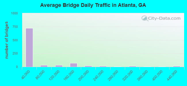
- 46,196,877Total average daily traffic
- 629,964Total average daily truck traffic
- National Bridge Inventory (NBI) Registered Bridges for Atlanta
- No street view available for this location
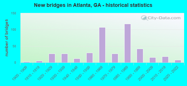
- New bridges - historical statistics
- 31900-1909
- 51910-1919
- 271920-1929
- 271930-1939
- 121940-1949
- 301950-1959
- 1071960-1969
- 271970-1979
- 1181980-1989
- 421990-1999
- 162000-2009
- 182010-2019
- 82020-2022
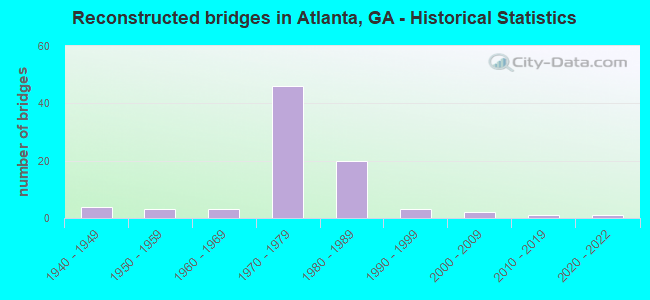
- Reconstructed bridges - Historical Statistics
- 41940-1949
- 31950-1959
- 31960-1969
- 461970-1979
- 201980-1989
- 31990-1999
- 22000-2009
- 12010-2019
- 12020-2022
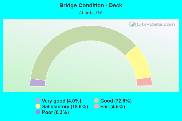
- Bridge Condition - Deck
- 4.0%Very good
- 72.6%Good
- 18.6%Satisfactory
- 4.5%Fair
- 0.3%Poor
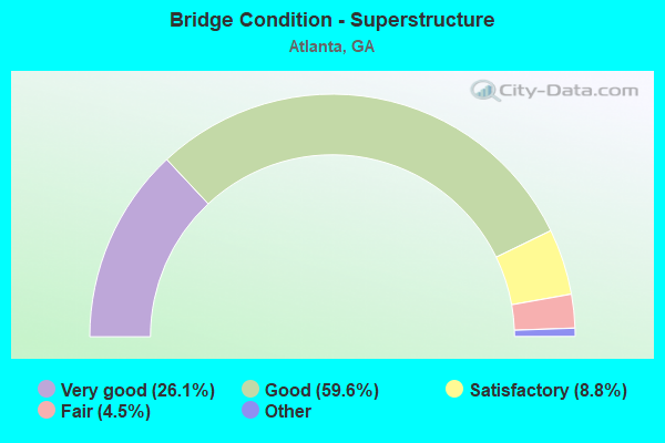
- Bridge Condition - Superstructure
- 26.1%Very good
- 59.6%Good
- 8.8%Satisfactory
- 4.5%Fair
- 1.1%Poor
- 0.3%Imminent failure
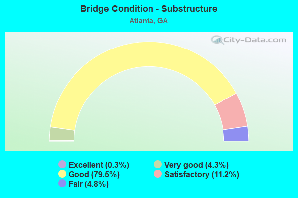
- Bridge Condition - Substructure
- 0.3%Excellent
- 4.3%Very good
- 79.5%Good
- 11.2%Satisfactory
- 4.8%Fair
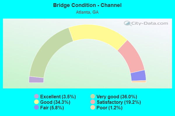
- Bridge Condition - Channel
- 3.5%Excellent
- 36.0%Very good
- 34.3%Good
- 19.2%Satisfactory
- 5.8%Fair
- 1.2%Poor
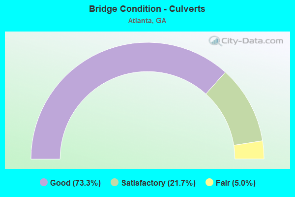
- Bridge Condition - Culverts
- 73.3%Good
- 21.7%Satisfactory
- 5.0%Fair
Find on map >> Show street view
Structure Number: 1210004, Location: IN N ATLANTA (Lat: 33.779939, Lng: -84.413078), Route carried "on" structure: City street 9003, Year Built: 1974, Status: Open, Structure Length: 5.79m (19.00ft), Average Daily Traffic: 15,500 (year 2011), Truck Traffic: 1%, Average Future Daily Traffic: 23,250 (year 2031), Design Load: HS 20+Mod, Features Intersected: CSX RAILROAD- SOU. RR., Facility Carried by Structure: MARIETTA STREET
Minimum Vertical Clearance: 30+ m (98+ ft), Kilometerpoint: 4.828, Lanes on structure: 4, Base Highway Network: Yes, Owner: City or Municipal Highway Agency, Approaching Roadway Width: 15.8m (51.8ft), Skew: 6 degrees, Material/Design: Steel, Design/Construction: Stringer/Multi-beam, Number Of Spans In Main Unit: 1, Length of Maximum Span: 57.9m (190.0ft), Curb or Sidewalk Widths: Left: 1.8m (5.9ft), Right: 1.8m (5.9ft), Curb-To-Curb Width: 15.8m (51.8ft), Out-to-Out Width: 20.2m (66.3ft)
Condition: Deck: Satisfactory, Superstructure: Good, Substructure: Good, Operating Rating: 89.8 metric tons, Method Used To Determine Operating Rating: Load Factor (LF), Inventory Rating: 58.9 metric tons, Method Used To Determine Inventory Rating: Load Factor (LF), Structural Evaluation: Better than present minimum criteria, Deck Geometry: Meets minimum limits, Underclear: Somewhat better than minimum adequacy, Approach Roadway Alignment: Equal to present desirable criteria, Designated Inspection Frequency: Every 24 months, Inspection Date: January 2021, Bridge Improvement Cost: $1,147,000, Roadway Improvement Cost: $115,000, Total Project Cost: $1,721,000, Deck Structure Type: Concrete Cast-file-Place
Find on map >> Show street view
Structure Number: 1210005, Location: IN N ATLANTA (Lat: 33.787189, Lng: -84.428047), Route carried "on" structure: City street 9003, Year Built: 1953, Status: Open, Structure Length: 11.80m (38.71ft), Average Daily Traffic: 13,670 (year 2011), Truck Traffic: 1%, Average Future Daily Traffic: 20,505 (year 2031), Design Load: H 20, Features Intersected: CSX RAILROAD- SOU. RR., Facility Carried by Structure: MARIETTA BLVD.
Minimum Vertical Clearance: 30+ m (98+ ft), Kilometerpoint: 6.437, Lanes on structure: 4, Base Highway Network: Yes, Owner: City or Municipal Highway Agency, Approaching Roadway Width: 34.1m (111.9ft), Skew: 20 degrees, Material/Design: Steel continuous, Design/Construction: Stringer/Multi-beam, Number Of Spans In Main Unit: 4, Length of Maximum Span: 48.5m (159.1ft), Curb or Sidewalk Widths: Left: 1.8m (5.9ft), Right: 1.8m (5.9ft), Curb-To-Curb Width: 17.5m (57.4ft), Out-to-Out Width: 21.9m (71.9ft)
Condition: Deck: Fair, Superstructure: Satisfactory, Substructure: Fair, Operating Rating: 34.4 metric tons, Method Used To Determine Operating Rating: Load Factor (LF), Inventory Rating: 20.8 metric tons, Method Used To Determine Inventory Rating: Load Factor (LF), Structural Evaluation: Somewhat better than minimum adequacy, Deck Geometry: Somewhat better than minimum adequacy, Underclear: Meets minimum limits, Approach Roadway Alignment: Equal to present desirable criteria, Designated Inspection Frequency: Every 24 months, Inspection Date: September 2020, Bridge Improvement Cost: $2,337,000, Roadway Improvement Cost: $234,000, Total Project Cost: $3,505,000, Deck Structure Type: Concrete Cast-file-Place
Find on map >> Show street view
Structure Number: 1210006, Location: IN N ATLANTA (Lat: 33.795408, Lng: -84.432339), Route carried "on" structure: City street 9003, Year Built: 1952, Status: Open, Structure Length: 2.38m (7.81ft), Average Daily Traffic: 13,670 (year 2011), Truck Traffic: 1%, Average Future Daily Traffic: 20,505 (year 2031), Design Load: H 20, Features Intersected: SPUR RAILROAD TRACK, Facility Carried by Structure: MARIETTA BLVD.
Minimum Vertical Clearance: 30+ m (98+ ft), Kilometerpoint: 6.437, Lanes on structure: 4, Base Highway Network: Yes, Owner: City or Municipal Highway Agency, Approaching Roadway Width: 17.1m (56.1ft), Skew: 2 degrees, Material/Design: Steel, Design/Construction: Stringer/Multi-beam, Number Of Spans In Main Unit: 3, Length of Maximum Span: 7.9m (25.9ft), Curb or Sidewalk Widths: Left: 1.8m (5.9ft), Right: 1.8m (5.9ft), Curb-To-Curb Width: 21.9m (71.9ft), Out-to-Out Width: 26.1m (85.6ft)
Condition: Deck: Good, Superstructure: Fair, Substructure: Good, Operating Rating: 54.4 metric tons, Method Used To Determine Operating Rating: Allowable Stress (AS), Inventory Rating: 32.6 metric tons, Method Used To Determine Inventory Rating: Allowable Stress (AS), Structural Evaluation: Somewhat better than minimum adequacy, Deck Geometry: Superior to present desirable criteria, Underclear: Meets minimum limits, Approach Roadway Alignment: Equal to present desirable criteria, Designated Inspection Frequency: Every 24 months, Inspection Date: October 2020, Bridge Improvement Cost: $471,000, Roadway Improvement Cost: $47,000, Total Project Cost: $706,000, Deck Structure Type: Concrete Cast-file-Place, Wearing Surface/Protective System: Wearing Surface: Bituminous, Membrane: Built-up
Find on map >> Show street view
Structure Number: 1210008, Location: IN ATLANTA (Lat: 33.742558, Lng: -84.406928), Route carried "on" structure: City street 9124, Year Built: 1990, Status: Open, Structure Length: 2.96m (9.71ft), Average Daily Traffic: 7,740 (year 2011), Truck Traffic: 1%, Average Future Daily Traffic: 11,610 (year 2031), Design Load: HS 20, Features Intersected: NS RAILROAD (718069H), Facility Carried by Structure: WHITEHALL STREET
Minimum Vertical Clearance: 30+ m (98+ ft), Kilometerpoint: 6.437, Lanes on structure: 4, Base Highway Network: Yes, Owner: City or Municipal Highway Agency, Approaching Roadway Width: 12.8m (42.0ft), Skew: 4 degrees, Material/Design: Steel, Design/Construction: Stringer/Multi-beam, Number Of Spans In Main Unit: 3, Length of Maximum Span: 21.3m (69.9ft), Curb or Sidewalk Widths: Left: 2.7m (8.9ft), Right: 1.8m (5.9ft), Curb-To-Curb Width: 12.8m (42.0ft), Out-to-Out Width: 19.5m (64.0ft)
Condition: Deck: Good, Superstructure: Good, Substructure: Good, Operating Rating: 46.2 metric tons, Method Used To Determine Operating Rating: Allowable Stress (AS), Inventory Rating: 32.6 metric tons, Method Used To Determine Inventory Rating: Allowable Stress (AS), Structural Evaluation: Better than present minimum criteria, Deck Geometry: High priority of replacement, Underclear: Meets minimum limits, Approach Roadway Alignment: Equal to present desirable criteria, Designated Inspection Frequency: Every 24 months, Inspection Date: October 2020, Bridge Improvement Cost: $586,000, Roadway Improvement Cost: $59,000, Total Project Cost: $879,000, Deck Structure Type: Concrete Cast-file-Place
Find on map >> Show street view
Structure Number: 1210009, Location: IN ATLANTA (Lat: 33.746619, Lng: -84.397850), Route carried "on" structure: City street 9124, Year Built: 1963, Status: Open, Structure Length: 6.55m (21.49ft), Average Daily Traffic: 7,740 (year 2011), Truck Traffic: 1%, Average Future Daily Traffic: 11,610 (year 2031), Design Load: HS 20+Mod, Features Intersected: M-9073 SPRING STREET, Facility Carried by Structure: WHITEHALL STREET
Minimum Vertical Clearance: 30+ m (98+ ft), Kilometerpoint: 8.047, Lanes on structure: 4, Lanes under structure: 5, Base Highway Network: Yes, Owner: City or Municipal Highway Agency, Approaching Roadway Width: 14.6m (47.9ft), Skew: 3 degrees, Material/Design: Steel continuous, Design/Construction: Stringer/Multi-beam, Number Of Spans In Main Unit: 4, Length of Maximum Span: 19.2m (63.0ft), Curb or Sidewalk Widths: Left: 2.4m (7.9ft), Right: 2.4m (7.9ft), Curb-To-Curb Width: 14.6m (47.9ft), Out-to-Out Width: 20.3m (66.6ft)
Condition: Deck: Satisfactory, Superstructure: Satisfactory, Substructure: Satisfactory, Operating Rating: 46.2 metric tons, Method Used To Determine Operating Rating: Allowable Stress (AS), Inventory Rating: 32.6 metric tons, Method Used To Determine Inventory Rating: Allowable Stress (AS), Structural Evaluation: Equal to present minimum criteria, Deck Geometry: High priority of replacement, Underclear: Meets minimum limits, Approach Roadway Alignment: Equal to present desirable criteria, Designated Inspection Frequency: Every 24 months, Inspection Date: July 2020, Bridge Improvement Cost: $1,298,000, Roadway Improvement Cost: $130,000, Total Project Cost: $1,947,000, Deck Structure Type: Concrete Cast-file-Place
Find on map >> Show street view
Structure Number: 121001, Location: DOWNTOWN ATLANTA (Lat: 33.755044, Lng: -84.393828), Route carried "on" structure: City street 9073, Year Built: 1997, Year Reconstructed: 2020, Status: Posted for load, Structure Length: 46.82m (153.61ft), Average Daily Traffic: 17,350 (year 2018), Truck Traffic: 1%, Average Future Daily Traffic: 24,615 (year 2031), Design Load: HS 20+Mod, Features Intersected: ALABAMA ST/CSX RR, Facility Carried by Structure: TED TURNER DRIVE
Minimum Vertical Clearance: 30+ m (98+ ft), Kilometerpoint: 1.529, Lanes on structure: 4, Lanes under structure: 2, Base Highway Network: Yes, Owner: City or Municipal Highway Agency, Approaching Roadway Width: 12.2m (40.0ft), Material/Design: Steel continuous, Design/Construction: Stringer/Multi-beam, Number Of Spans In Main Unit: 2, Number Of Approach Spans: 17, Length of Maximum Span: 65.5m (214.9ft), Curb or Sidewalk Widths: Left: 3.0m (9.8ft), Right: 3.0m (9.8ft), Curb-To-Curb Width: 12.2m (40.0ft), Out-to-Out Width: 18.2m (59.7ft)
Condition: Deck: Good, Superstructure: Very good, Substructure: Good, Operating Rating: 25.4 metric tons, Method Used To Determine Operating Rating: Allowable Stress (AS), Inventory Rating: 11.7 metric tons, Method Used To Determine Inventory Rating: Allowable Stress (AS), Structural Evaluation: High priority of replacement, Deck Geometry: High priority of replacement, Underclear: Meets minimum limits, Approach Roadway Alignment: Equal to present desirable criteria, Bridge Posting: Required (Relationship of Operating Rating to Maximum Legal Load: 20.0 - 29.9% below), Length Of Structure Improvement: 53.28m (174.80ft), Designated Inspection Frequency: Every 24 months, Inspection Date: January 2021, Bridge Improvement Cost: $9,281,000, Roadway Improvement Cost: $928,000, Total Project Cost: $13,922,000, Deck Structure Type: Concrete Cast-file-Place
Find on map >> Show street view
Structure Number: 1210011, Location: IN N ATLANTA (Lat: 33.776569, Lng: -84.406328), Route carried "on" structure: US 41, Year Built: 1974, Status: Open, Structure Length: 6.77m (22.21ft), Average Daily Traffic: 28,050 (year 2012), Truck Traffic: 1%, Average Future Daily Traffic: 42,075 (year 2032), Design Load: HS 20+Mod, Features Intersected: M-9150 THIRD STREET, Facility Carried by Structure: NORTHSIDE DR (NBL)
Minimum Vertical Clearance: 30+ m (98+ ft), Kilometerpoint: 16.093, Lanes on structure: 2, Lanes under structure: 4, Base Highway Network: Yes, Owner: State Highway Agency, Approaching Roadway Width: 12.2m (40.0ft), Skew: 2 degrees, Material/Design: Steel, Design/Construction: Stringer/Multi-beam, Number Of Spans In Main Unit: 4, Length of Maximum Span: 22.3m (73.2ft), Curb or Sidewalk Widths: Left: 0.6m (2.0ft), Right: 0.6m (2.0ft), Curb-To-Curb Width: 12.2m (40.0ft), Out-to-Out Width: 14.2m (46.6ft)
Condition: Deck: Satisfactory, Superstructure: Good, Substructure: Satisfactory, Operating Rating: 46.2 metric tons, Method Used To Determine Operating Rating: Allowable Stress (AS), Inventory Rating: 32.6 metric tons, Method Used To Determine Inventory Rating: Allowable Stress (AS), Structural Evaluation: Equal to present minimum criteria, Deck Geometry: Better than present minimum criteria, Underclear: Better than present minimum criteria, Approach Roadway Alignment: Equal to present desirable criteria, Designated Inspection Frequency: Every 24 months, Inspection Date: April 2021, Bridge Improvement Cost: $867,000, Roadway Improvement Cost: $87,000, Total Project Cost: $1,301,000, Deck Structure Type: Concrete Cast-file-Place
Find on map >> Show street view
Structure Number: 1210012, Location: IN NORTH ATLANTA (Lat: 33.802569, Lng: -84.407803), Route carried "on" structure: US 41, Year Built: 1986, Status: Open, Structure Length: 5.64m (18.50ft), Average Daily Traffic: 25,490 (year 2012), Truck Traffic: 1%, Average Future Daily Traffic: 38,235 (year 2032), Design Load: HS 20+Mod, Features Intersected: I-75 (SBL) + I-75 RAMP, Facility Carried by Structure: NORTHSIDE DRIVE
Minimum Vertical Clearance: 30+ m (98+ ft), Kilometerpoint: 19.312, Lanes on structure: 7, Lanes under structure: 7, Base Highway Network: Yes, Owner: State Highway Agency, Approaching Roadway Width: 26.8m (87.9ft), Material/Design: Prestressed concrete, Design/Construction: Stringer/Multi-beam, Number Of Spans In Main Unit: 2, Length of Maximum Span: 28.7m (94.2ft), Curb or Sidewalk Widths: Left: 1.8m (5.9ft), Right: 1.8m (5.9ft), Curb-To-Curb Width: 27.4m (89.9ft), Out-to-Out Width: 31.8m (104.3ft)
Condition: Deck: Good, Superstructure: Good, Substructure: Satisfactory, Operating Rating: 45.3 metric tons, Method Used To Determine Operating Rating: Allowable Stress (AS), Inventory Rating: 32.6 metric tons, Method Used To Determine Inventory Rating: Allowable Stress (AS), Structural Evaluation: Equal to present minimum criteria, Deck Geometry: Somewhat better than minimum adequacy, Underclear: Somewhat better than minimum adequacy, Approach Roadway Alignment: Equal to present desirable criteria, Designated Inspection Frequency: Every 24 months, Inspection Date: September 2020, Bridge Improvement Cost: $1,709,000, Roadway Improvement Cost: $171,000, Total Project Cost: $2,563,000, Deck Structure Type: Concrete Precast Panels, Wearing Surface/Protective System: Deck Protection: Epoxy Coated Reinforcing
Find on map >> Show street view
Structure Number: 1210014, Location: IN N ATLANTA (Lat: 33.853608, Lng: -84.430978), Route carried "on" structure: US 41, Year Built: 1938, Year Reconstructed: 1954, Status: Posted for load, Structure Length: 2.62m (8.60ft), Average Daily Traffic: 22,330 (year 2012), Truck Traffic: 1%, Average Future Daily Traffic: 33,495 (year 2032), Design Load: H 20, Features Intersected: NANCY CREEK, Facility Carried by Structure: N'SIDE PARKWAY US
Minimum Vertical Clearance: 30+ m (98+ ft), Kilometerpoint: 25.750, Lanes on structure: 4, Base Highway Network: Yes, Owner: State Highway Agency, Approaching Roadway Width: 17.7m (58.1ft), Skew: 20 degrees, Material/Design: Concrete, Design/Construction: Tee Beam, Number Of Spans In Main Unit: 3, Length of Maximum Span: 9.1m (29.9ft), Curb or Sidewalk Widths: Left: 1.3m (4.3ft), Right: 1.3m (4.3ft), Curb-To-Curb Width: 19.3m (63.3ft), Out-to-Out Width: 22.2m (72.8ft)
Condition: Deck: Good, Superstructure: Good, Substructure: Good, Channel: Good, Operating Rating: 43.5 metric tons, Method Used To Determine Operating Rating: Load Factor (LF), Inventory Rating: 26.3 metric tons, Method Used To Determine Inventory Rating: Load Factor (LF), Structural Evaluation: Equal to present minimum criteria, Deck Geometry: Equal to present minimum criteria, Waterway Adequacy: Equal to present desirable criteria, Approach Roadway Alignment: Equal to present desirable criteria, Bridge Posting: Required (Relationship of Operating Rating to Maximum Legal Load: 10.0 - 19.9% below), Designated Inspection Frequency: Every 24 months, Inspection Date: June 2021, Bridge Improvement Cost: $519,000, Roadway Improvement Cost: $52,000, Total Project Cost: $779,000, Deck Structure Type: Concrete Cast-file-Place, Wearing Surface/Protective System: Wearing Surface: Bituminous
Find on map >> Show street view
Structure Number: 1210016, Location: IN ATLANTA (Lat: 33.703328, Lng: -84.405019), Route carried "on" structure: City street 9204, Year Built: 1965, Status: Open, Structure Length: 0.88m (2.89ft), Average Daily Traffic: 5,090 (year 2011), Truck Traffic: 1%, Average Future Daily Traffic: 7,635 (year 2031), Design Load: HS 20+Mod, Features Intersected: SOUTH RIVER TRIB, Facility Carried by Structure: FAIR DRIVE
Minimum Vertical Clearance: 30+ m (98+ ft), Kilometerpoint: 0.000, Lanes on structure: 4, Base Highway Network: Yes, Owner: City or Municipal Highway Agency, Approaching Roadway Width: 15.8m (51.8ft), Skew: 4 degrees, Material/Design: Concrete, Design/Construction: Culvert, Number Of Spans In Main Unit: 2, Length of Maximum Span: 4.3m (14.1ft)
Condition: Channel: Very good, Culverts: Good, Structural Evaluation: Better than present minimum criteria, Waterway Adequacy: Superior to present desirable criteria, Approach Roadway Alignment: Equal to present desirable criteria, Designated Inspection Frequency: Every 24 months, Inspection Date: September 2020, Bridge Improvement Cost: $175,000, Roadway Improvement Cost: $18,000, Total Project Cost: $263,000
Find on map >> Show street view
Structure Number: 1210017, Location: IN SOUTH ATLANTA (Lat: 33.703089, Lng: -84.403989), Route carried "on" structure: City street 3483, Year Built: 1986, Status: Open, Structure Length: 8.38m (27.49ft), Average Daily Traffic: 5,080 (year 2012), Truck Traffic: 1%, Average Future Daily Traffic: 7,620 (year 2032), Design Load: HS 20+Mod, Features Intersected: I-75, Facility Carried by Structure: FAIR DRIVE
Minimum Vertical Clearance: 30+ m (98+ ft), Kilometerpoint: 0.000, Lanes on structure: 4, Lanes under structure: 16, Base Highway Network: Yes, Owner: State Highway Agency, Approaching Roadway Width: 15.8m (51.8ft), Skew: 1 degrees, Material/Design: Steel continuous, Design/Construction: Stringer/Multi-beam, Number Of Spans In Main Unit: 2, Length of Maximum Span: 42.1m (138.1ft), Curb or Sidewalk Widths: Left: 2.4m (7.9ft), Right: 2.4m (7.9ft), Curb-To-Curb Width: 15.9m (52.2ft), Out-to-Out Width: 21.4m (70.2ft)
Condition: Deck: Good, Superstructure: Very good, Substructure: Good, Operating Rating: 37.1 metric tons, Method Used To Determine Operating Rating: Load Factor (LF), Inventory Rating: 21.7 metric tons, Method Used To Determine Inventory Rating: Load Factor (LF), Structural Evaluation: Somewhat better than minimum adequacy, Deck Geometry: Meets minimum limits, Underclear: High priority of corrective action, Approach Roadway Alignment: Equal to present desirable criteria, Designated Inspection Frequency: Every 24 months, Inspection Date: April 2021, Bridge Improvement Cost: $1,661,000, Roadway Improvement Cost: $166,000, Total Project Cost: $2,491,000, Deck Structure Type: Concrete Cast-file-Place, Wearing Surface/Protective System: Deck Protection: Epoxy Coated Reinforcing
Find on map >> Show street view
Structure Number: 1210018, Location: IN ATLANTA (Lat: 33.702639, Lng: -84.400308), Route carried "on" structure: City street 9204, Year Built: 1965, Status: Open, Structure Length: 1.77m (5.81ft), Average Daily Traffic: 5,090 (year 2011), Truck Traffic: 1%, Average Future Daily Traffic: 7,635 (year 2031), Design Load: HS 20+Mod, Features Intersected: SOUTH RIVER TRIB, Facility Carried by Structure: FAIR DRIVE
Minimum Vertical Clearance: 30+ m (98+ ft), Kilometerpoint: 0.000, Lanes on structure: 5, Base Highway Network: Yes, Owner: City or Municipal Highway Agency, Approaching Roadway Width: 15.8m (51.8ft), Skew: 6 degrees, Material/Design: Concrete, Design/Construction: Culvert, Number Of Spans In Main Unit: 3, Length of Maximum Span: 5.5m (18.0ft), Curb or Sidewalk Widths: Left: 1.2m (3.9ft), Right: 1.2m (3.9ft)
Condition: Channel: Satisfactory, Culverts: Good, Structural Evaluation: Better than present minimum criteria, Waterway Adequacy: Superior to present desirable criteria, Approach Roadway Alignment: Equal to present desirable criteria, Designated Inspection Frequency: Every 24 months, Inspection Date: September 2020, Bridge Improvement Cost: $412,000, Roadway Improvement Cost: $41,000, Total Project Cost: $618,000
Find on map >> Show street view
Structure Number: 1210019, Location: IN NW ATLANTA (Lat: 33.786858, Lng: -84.493119), Route carried "on" structure: US 78, Year Built: 1964, Year Reconstructed: 1987, Status: Open, Structure Length: 6.52m (21.39ft), Average Daily Traffic: 27,200 (year 2012), Truck Traffic: 1%, Average Future Daily Traffic: 40,800 (year 2032), Design Load: HS 20+Mod, Features Intersected: I-285, Facility Carried by Structure: BANKHEAD HIGHWAY U
Minimum Vertical Clearance: 30+ m (98+ ft), Kilometerpoint: 1.609, Lanes on structure: 6, Lanes under structure: 8, Base Highway Network: Yes, Owner: State Highway Agency, Approaching Roadway Width: 23.2m (76.1ft), Material/Design: Steel continuous, Design/Construction: Stringer/Multi-beam, Number Of Spans In Main Unit: 4, Length of Maximum Span: 21.3m (69.9ft), Curb or Sidewalk Widths: Left: 1.2m (3.9ft), Right: 1.8m (5.9ft), Curb-To-Curb Width: 23.2m (76.1ft), Out-to-Out Width: 26.3m (86.3ft)
Condition: Deck: Satisfactory, Superstructure: Good, Substructure: Good, Operating Rating: 41.7 metric tons, Method Used To Determine Operating Rating: Load Factor (LF), Inventory Rating: 24.4 metric tons, Method Used To Determine Inventory Rating: Load Factor (LF), Structural Evaluation: Equal to present minimum criteria, Deck Geometry: Meets minimum limits, Underclear: Meets minimum limits, Approach Roadway Alignment: Equal to present desirable criteria, Designated Inspection Frequency: Every 24 months, Inspection Date: March 2021, Deck Structure Type: Concrete Cast-file-Place
Find on map >> Show street view
Structure Number: 121002, Location: IN W ATLANTA (Lat: 33.771928, Lng: -84.429908), Route carried "on" structure: US 78, Year Built: 1930, Status: Open, Structure Length: 1.40m (4.59ft), Average Daily Traffic: 13,940 (year 2012), Truck Traffic: 1%, Average Future Daily Traffic: 20,910 (year 2032), Design Load: H 15, Features Intersected: PROCTOR CREEK, Facility Carried by Structure: DONALD LEE HOLLOWA
Minimum Vertical Clearance: 30+ m (98+ ft), Kilometerpoint: 8.047, Lanes on structure: 4, Base Highway Network: Yes, Owner: State Highway Agency, Approaching Roadway Width: 14.6m (47.9ft), Material/Design: Concrete, Design/Construction: Arch - Deck, Number Of Spans In Main Unit: 1, Length of Maximum Span: 14.0m (45.9ft), Curb or Sidewalk Widths: Left: 1.8m (5.9ft), Right: 1.8m (5.9ft), Curb-To-Curb Width: 14.6m (47.9ft), Out-to-Out Width: 18.7m (61.4ft)
Condition: Deck: Satisfactory, Superstructure: Satisfactory, Substructure: Satisfactory, Channel: Satisfactory, Operating Rating: 34.4 metric tons, Method Used To Determine Operating Rating: Allowable Stress (AS), Inventory Rating: 19.0 metric tons, Method Used To Determine Inventory Rating: Allowable Stress (AS), Structural Evaluation: Meets minimum limits, Deck Geometry: High priority of replacement, Waterway Adequacy: Equal to present minimum criteria, Approach Roadway Alignment: Equal to present desirable criteria, Designated Inspection Frequency: Every 24 months, Inspection Date: April 2021, Bridge Improvement Cost: $278,000, Roadway Improvement Cost: $28,000, Total Project Cost: $417,000, Deck Structure Type: Concrete Cast-file-Place, Wearing Surface/Protective System: Wearing Surface: Bituminous
Find on map >> Show street view
Structure Number: 1210022, Location: IN ATLANTA (Lat: 33.771278, Lng: -84.390028), Route carried "on" structure: US 8, Year Built: 1983, Status: Open, Structure Length: 7.71m (25.30ft), Average Daily Traffic: 27,520 (year 2012), Truck Traffic: 1%, Average Future Daily Traffic: 41,280 (year 2032), Design Load: HS 20+Mod, Features Intersected: I-75, Facility Carried by Structure: NORTH AVENUE
Minimum Vertical Clearance: 30+ m (98+ ft), Kilometerpoint: 12.875, Lanes on structure: 5, Lanes under structure: 15, Base Highway Network: Yes, Owner: State Highway Agency, Approaching Roadway Width: 18.3m (60.0ft), Material/Design: Steel continuous, Design/Construction: Stringer/Multi-beam, Number Of Spans In Main Unit: 2, Length of Maximum Span: 44.8m (147.0ft), Curb or Sidewalk Widths: Left: 3.7m (12.1ft), Right: 3.7m (12.1ft), Curb-To-Curb Width: 21.3m (69.9ft), Out-to-Out Width: 29.4m (96.5ft)
Condition: Deck: Good, Superstructure: Very good, Substructure: Good, Operating Rating: 47.1 metric tons, Method Used To Determine Operating Rating: Load Factor (LF), Inventory Rating: 28.1 metric tons, Method Used To Determine Inventory Rating: Load Factor (LF), Structural Evaluation: Better than present minimum criteria, Deck Geometry: Somewhat better than minimum adequacy, Underclear: Meets minimum limits, Approach Roadway Alignment: Equal to present desirable criteria, Designated Inspection Frequency: Every 24 months, Inspection Date: April 2021, Bridge Improvement Cost: $1,797,000, Roadway Improvement Cost: $180,000, Total Project Cost: $2,696,000, Deck Structure Type: Concrete Precast Panels, Wearing Surface/Protective System: Deck Protection: Epoxy Coated Reinforcing
Find on map >> Show street view
Structure Number: 1210023, Location: IN ATLANTA (Lat: 33.754300, Lng: -84.366558), Route carried "on" structure: City street 9184, Year Built: 1941, Status: Open, Structure Length: 1.37m (4.49ft), Average Daily Traffic: 9,800 (year 2011), Truck Traffic: 1%, Average Future Daily Traffic: 14,700 (year 2031), Design Load: H 20, Features Intersected: CS 3474 AIRLINE STREET, Facility Carried by Structure: EDGEWOOD AVE.
Minimum Vertical Clearance: 30+ m (98+ ft), Kilometerpoint: 1.609, Lanes on structure: 4, Lanes under structure: 2, Base Highway Network: Yes, Owner: City or Municipal Highway Agency, Approaching Roadway Width: 9.8m (32.2ft), Skew: 1 degrees, Material/Design: Steel, Design/Construction: Stringer/Multi-beam, Number Of Spans In Main Unit: 1, Length of Maximum Span: 13.7m (44.9ft), Curb or Sidewalk Widths: Left: 2.9m (9.5ft), Right: 2.9m (9.5ft), Curb-To-Curb Width: 12.2m (40.0ft), Out-to-Out Width: 18.2m (59.7ft)
Condition: Deck: Good, Superstructure: Good, Substructure: Good, Operating Rating: 84.3 metric tons, Method Used To Determine Operating Rating: Load Factor (LF), Inventory Rating: 50.8 metric tons, Method Used To Determine Inventory Rating: Load Factor (LF), Structural Evaluation: Better than present minimum criteria, Deck Geometry: High priority of replacement, Underclear: High priority of replacement, Approach Roadway Alignment: Equal to present desirable criteria, Length Of Structure Improvement: 7.80m (25.59ft), Designated Inspection Frequency: Every 24 months, Inspection Date: October 2020, Bridge Improvement Cost: $272,000, Roadway Improvement Cost: $27,000, Total Project Cost: $408,000, Deck Structure Type: Concrete Cast-file-Place, Wearing Surface/Protective System: Wearing Surface: Bituminous, Membrane: Built-up
Find on map >> Show street view
Structure Number: 1210025, Location: IN ATLANTA (Lat: 33.767483, Lng: -84.388908), Route carried "on" structure: City street 9073, Year Built: 1983, Status: Open, Structure Length: 12.71m (41.70ft), Average Daily Traffic: 7,750 (year 2010), Truck Traffic: 2%, Average Future Daily Traffic: 11,625 (year 2030), Design Load: HS 20+Mod, Features Intersected: I-75, Facility Carried by Structure: SPRING STREET
Minimum Vertical Clearance: 30+ m (98+ ft), Kilometerpoint: 3.219, Lanes on structure: 3, Lanes under structure: 14, Base Highway Network: Yes, Owner: State Highway Agency, Approaching Roadway Width: 15.8m (51.8ft), Skew: 19 degrees, Material/Design: Prestressed concrete continuous, Design/Construction: Box Beam or Girders - Single/Spread, Number Of Spans In Main Unit: 2, Length of Maximum Span: 66.1m (216.9ft), Curb or Sidewalk Widths: Left: 2.4m (7.9ft), Right: 2.4m (7.9ft), Curb-To-Curb Width: 15.8m (51.8ft), Out-to-Out Width: 21.5m (70.5ft)
Condition: Deck: Good, Superstructure: Good, Substructure: Good, Operating Rating: 55.3 metric tons, Method Used To Determine Operating Rating: Allowable Stress (AS), Inventory Rating: 32.6 metric tons, Method Used To Determine Inventory Rating: Allowable Stress (AS), Structural Evaluation: Better than present minimum criteria, Deck Geometry: Better than present minimum criteria, Underclear: High priority of corrective action, Approach Roadway Alignment: Equal to present desirable criteria, Designated Inspection Frequency: Every 24 months, Inspection Date: May 2021, Deck Structure Type: Concrete Cast-file-Place, Wearing Surface/Protective System: Wearing Surface: Epoxy Overlay
Find on map >> Show street view
Structure Number: 1210026, Location: IN N ATLANTA (Lat: 33.799197, Lng: -84.391989), Route carried "on" structure: US 19, Year Built: 1985, Status: Open, Structure Length: 11.37m (37.30ft), Average Daily Traffic: 33,360 (year 2012), Truck Traffic: 2%, Average Future Daily Traffic: 50,040 (year 2032), Design Load: HS 20+Mod, Features Intersected: I-85- SR 13 + RAILROAD, Facility Carried by Structure: PEACHTREE STREET U
Minimum Vertical Clearance: 30+ m (98+ ft), Kilometerpoint: 3.219, Lanes on structure: 7, Lanes under structure: 16, Base Highway Network: Yes, Owner: State Highway Agency, Approaching Roadway Width: 26.8m (87.9ft), Material/Design: Steel continuous, Design/Construction: Stringer/Multi-beam, Number Of Spans In Main Unit: 2, Length of Maximum Span: 57.0m (187.0ft), Curb or Sidewalk Widths: Left: 3.7m (12.1ft), Right: 2.7m (8.9ft), Curb-To-Curb Width: 26.8m (87.9ft), Out-to-Out Width: 34.0m (111.5ft)
Condition: Deck: Good, Superstructure: Good, Substructure: Good, Operating Rating: 46.2 metric tons, Method Used To Determine Operating Rating: Allowable Stress (AS), Inventory Rating: 32.6 metric tons, Method Used To Determine Inventory Rating: Allowable Stress (AS), Structural Evaluation: Better than present minimum criteria, Deck Geometry: Somewhat better than minimum adequacy, Underclear: Meets minimum limits, Approach Roadway Alignment: Equal to present desirable criteria, Designated Inspection Frequency: Every 24 months, Inspection Date: June 2021, Bridge Improvement Cost: $3,445,000, Roadway Improvement Cost: $344,000, Total Project Cost: $5,167,000, Deck Structure Type: Concrete Cast-file-Place, Wearing Surface/Protective System: Deck Protection: Epoxy Coated Reinforcing
Find on map >> Show street view
Structure Number: 1210028, Location: IN N ATLANTA (Lat: 33.811619, Lng: -84.392289), Route carried "on" structure: US 19, Year Built: 1914, Status: Open, Structure Length: 3.47m (11.38ft), Average Daily Traffic: 40,210 (year 2012), Truck Traffic: 2%, Average Future Daily Traffic: 60,315 (year 2032), Design Load: H 15, Features Intersected: CSX RAILROAD, Facility Carried by Structure: PEACHTREE STREET
Minimum Vertical Clearance: 30+ m (98+ ft), Kilometerpoint: 4.828, Lanes on structure: 6, Base Highway Network: Yes, Owner: State Highway Agency, Approaching Roadway Width: 18.3m (60.0ft), Material/Design: Concrete continuous, Design/Construction: Tee Beam, Number Of Spans In Main Unit: 3, Length of Maximum Span: 11.9m (39.0ft), Curb or Sidewalk Widths: Left: 2.4m (7.9ft), Right: 2.4m (7.9ft), Curb-To-Curb Width: 18.3m (60.0ft), Out-to-Out Width: 23.9m (78.4ft)
Condition: Deck: Fair, Superstructure: Fair, Substructure: Fair, Operating Rating: 34.4 metric tons, Method Used To Determine Operating Rating: Allowable Stress (AS), Inventory Rating: 19.9 metric tons, Method Used To Determine Inventory Rating: Allowable Stress (AS), Structural Evaluation: Somewhat better than minimum adequacy, Deck Geometry: High priority of replacement, Underclear: Meets minimum limits, Approach Roadway Alignment: Equal to present desirable criteria, Designated Inspection Frequency: Every 24 months, Inspection Date: June 2021, Bridge Improvement Cost: $931,000, Roadway Improvement Cost: $93,000, Total Project Cost: $1,397,000, Deck Structure Type: Concrete Cast-file-Place, Wearing Surface/Protective System: Wearing Surface: Bituminous, Membrane: Built-up
Find on map >> Show street view
Structure Number: 1210029, Location: IN N ATLANTA (Lat: 33.817619, Lng: -84.389219), Route carried "on" structure: US 19, Year Built: 1931, Status: Open, Structure Length: 5.52m (18.11ft), Average Daily Traffic: 40,210 (year 2012), Truck Traffic: 2%, Average Future Daily Traffic: 60,315 (year 2032), Design Load: H 15, Features Intersected: PEACHTREE CREEK
Minimum Vertical Clearance: 30+ m (98+ ft), Kilometerpoint: 4.828, Lanes on structure: 6, Base Highway Network: Yes, Owner: State Highway Agency, Approaching Roadway Width: 18.3m (60.0ft), Material/Design: Concrete continuous, Design/Construction: Tee Beam, Number Of Spans In Main Unit: 5, Length of Maximum Span: 11.9m (39.0ft), Curb or Sidewalk Widths: Left: 2.9m (9.5ft), Right: 2.9m (9.5ft), Curb-To-Curb Width: 18.3m (60.0ft), Out-to-Out Width: 24.1m (79.1ft)
Condition: Deck: Satisfactory, Superstructure: Satisfactory, Substructure: Satisfactory, Channel: Good, Operating Rating: 45.3 metric tons, Method Used To Determine Operating Rating: Allowable Stress (AS), Inventory Rating: 32.6 metric tons, Method Used To Determine Inventory Rating: Allowable Stress (AS), Structural Evaluation: Equal to present minimum criteria, Deck Geometry: High priority of replacement, Waterway Adequacy: Equal to present minimum criteria, Approach Roadway Alignment: Equal to present desirable criteria, Designated Inspection Frequency: Every 24 months, Inspection Date: June 2021, Bridge Improvement Cost: $1,479,000, Roadway Improvement Cost: $148,000, Total Project Cost: $2,218,000, Deck Structure Type: Concrete Cast-file-Place, Wearing Surface/Protective System: Wearing Surface: Bituminous
Find on map >> Show street view
Structure Number: 1210036, Location: IN N ATLANTA (Lat: 33.795169, Lng: -84.370878), Route carried "on" structure: City street 9007, Year Built: 1936, Status: Open, Structure Length: 2.65m (8.69ft), Average Daily Traffic: 20,160 (year 2011), Truck Traffic: 1%, Average Future Daily Traffic: 30,240 (year 2031), Design Load: H 15, Features Intersected: ATLANTA BELTLINE, Facility Carried by Structure: PIEDMONT AVE.
Minimum Vertical Clearance: 30+ m (98+ ft), Kilometerpoint: 8.047, Lanes on structure: 4, Base Highway Network: Yes, Owner: City or Municipal Highway Agency, Approaching Roadway Width: 13.4m (44.0ft), Skew: 3 degrees, Material/Design: Concrete, Design/Construction: Tee Beam, Number Of Spans In Main Unit: 3, Length of Maximum Span: 8.8m (28.9ft), Curb or Sidewalk Widths: Left: 2.4m (7.9ft), Right: 2.4m (7.9ft), Curb-To-Curb Width: 13.4m (44.0ft), Out-to-Out Width: 19.0m (62.3ft)
Condition: Deck: Satisfactory, Superstructure: Good, Substructure: Good, Operating Rating: 52.6 metric tons, Method Used To Determine Operating Rating: Load Factor (LF), Inventory Rating: 31.7 metric tons, Method Used To Determine Inventory Rating: Load Factor (LF), Structural Evaluation: Better than present minimum criteria, Deck Geometry: High priority of replacement, Underclear: High priority of corrective action, Approach Roadway Alignment: Equal to present desirable criteria, Designated Inspection Frequency: Every 24 months, Inspection Date: May 2020, Bridge Improvement Cost: $525,000, Roadway Improvement Cost: $53,000, Total Project Cost: $788,000, Deck Structure Type: Concrete Cast-file-Place, Wearing Surface/Protective System: Wearing Surface: Bituminous, Membrane: Built-up
Find on map >> Show street view
Structure Number: 1210037, Location: IN N ATLANTA (Lat: 33.796128, Lng: -84.369950), Route carried "on" structure: City street 9007, Year Built: 1964, Status: Open, Structure Length: 4.57m (14.99ft), Average Daily Traffic: 20,140 (year 2011), Truck Traffic: 1%, Average Future Daily Traffic: 30,210 (year 2031), Design Load: HS 20+Mod, Features Intersected: CLEAR CREEK, Facility Carried by Structure: PIEDMONT AVE.
Minimum Vertical Clearance: 30+ m (98+ ft), Kilometerpoint: 9.656, Lanes on structure: 4, Base Highway Network: Yes, Owner: City or Municipal Highway Agency, Approaching Roadway Width: 13.4m (44.0ft), Material/Design: Steel, Design/Construction: Stringer/Multi-beam, Number Of Spans In Main Unit: 3, Length of Maximum Span: 15.2m (49.9ft), Curb or Sidewalk Widths: Left: 2.4m (7.9ft), Right: 2.4m (7.9ft), Curb-To-Curb Width: 15.8m (51.8ft), Out-to-Out Width: 21.2m (69.6ft)
Condition: Deck: Satisfactory, Superstructure: Satisfactory, Substructure: Fair, Channel: Very good, Operating Rating: 45.3 metric tons, Method Used To Determine Operating Rating: Allowable Stress (AS), Inventory Rating: 31.7 metric tons, Method Used To Determine Inventory Rating: Allowable Stress (AS), Structural Evaluation: Somewhat better than minimum adequacy, Deck Geometry: Meets minimum limits, Waterway Adequacy: Superior to present desirable criteria, Approach Roadway Alignment: Equal to present desirable criteria, Designated Inspection Frequency: Every 24 months, Inspection Date: May 2020, Bridge Improvement Cost: $906,000, Roadway Improvement Cost: $91,000, Total Project Cost: $1,359,000, Deck Structure Type: Concrete Cast-file-Place, Wearing Surface/Protective System: Wearing Surface: Bituminous, Membrane: Built-up
Find on map >> Show street view
Structure Number: 1210038, Location: IN N ATLANTA (Lat: 33.811147, Lng: -84.357308), Route carried "on" structure: City street 9213, Year Built: 1937, Status: Open, Structure Length: 6.13m (20.11ft), Average Daily Traffic: 19,790 (year 2011), Truck Traffic: 1%, Average Future Daily Traffic: 29,685 (year 2031), Design Load: H 15, Features Intersected: CSX RAILROAD (639814N), Facility Carried by Structure: CHESTER BRIDGE RD
Minimum Vertical Clearance: 30+ m (98+ ft), Kilometerpoint: 0.000, Lanes on structure: 4, Base Highway Network: Yes, Owner: City or Municipal Highway Agency, Approaching Roadway Width: 12.2m (40.0ft), Skew: 4 degrees, Material/Design: Steel, Design/Construction: Stringer/Multi-beam, Number Of Spans In Main Unit: 1, Number Of Approach Spans: 4, Length of Maximum Span: 18.6m (61.0ft), Curb or Sidewalk Widths: Left: 1.5m (4.9ft), Right: 1.5m (4.9ft), Curb-To-Curb Width: 12.2m (40.0ft), Out-to-Out Width: 15.8m (51.8ft)
Condition: Deck: Good, Superstructure: Good, Substructure: Satisfactory, Operating Rating: 45.3 metric tons, Method Used To Determine Operating Rating: Load Factor (LF), Inventory Rating: 27.2 metric tons, Method Used To Determine Inventory Rating: Load Factor (LF), Structural Evaluation: Equal to present minimum criteria, Deck Geometry: High priority of replacement, Underclear: Meets minimum limits, Approach Roadway Alignment: Equal to present desirable criteria, Length Of Structure Improvement: 12.56m (41.21ft), Designated Inspection Frequency: Every 24 months, Inspection Date: Febuary 2021, Bridge Improvement Cost: $1,214,000, Roadway Improvement Cost: $121,000, Total Project Cost: $1,821,000, Deck Structure Type: Concrete Cast-file-Place, Wearing Surface/Protective System: Wearing Surface: Bituminous, Membrane: Built-up
Find on map >> Show street view
Structure Number: 1210039, Location: IN N ATLANTA (Lat: 33.812908, Lng: -84.354258), Route carried "on" structure: City street 9213, Year Built: 1938, Status: Closed, Structure Length: 5.85m (19.19ft), Average Daily Traffic: 19,790 (year 2011), Truck Traffic: 1%, Average Future Daily Traffic: 29,685 (year 2031), Design Load: H 15, Features Intersected: SOUTH FORK P'TREE CREEK, Facility Carried by Structure: CHESHIRE BRIDGE RD
Minimum Vertical Clearance: 30+ m (98+ ft), Kilometerpoint: 1.609, Lanes on structure: 4, Base Highway Network: Yes, Owner: City or Municipal Highway Agency, Approaching Roadway Width: 12.2m (40.0ft), Material/Design: Concrete, Design/Construction: Tee Beam, Number Of Spans In Main Unit: 5, Length of Maximum Span: 12.2m (40.0ft), Curb or Sidewalk Widths: Left: 1.5m (4.9ft), Right: 1.5m (4.9ft), Curb-To-Curb Width: 12.2m (40.0ft), Out-to-Out Width: 15.8m (51.8ft)
Condition: Deck: Satisfactory, Superstructure: Imminent failure, Substructure: Satisfactory, Channel: Satisfactory, Waterway Adequacy: Equal to present desirable criteria, Approach Roadway Alignment: Equal to present desirable criteria, Bridge Posting: Required (Relationship of Operating Rating to Maximum Legal Load: > 39.9% below), Designated Inspection Frequency: Every 24 months, Other Special Inspection Frequency: Every 12 months, Inspection Date: Febuary 2021, Other Special Inspection Date: Febuary 2022, Bridge Improvement Cost: $1,159,000, Roadway Improvement Cost: $116,000, Total Project Cost: $1,739,000, Deck Structure Type: Concrete Cast-file-Place
Find on map >> Show street view
Structure Number: 121004, Location: IN N W ATLANTA (Lat: 33.824419, Lng: -84.352308), Route carried "on" structure: City street 9213, Year Built: 1977, Year Reconstructed: 1981, Status: Open, Structure Length: 4.63m (15.19ft), Average Daily Traffic: 44,980 (year 2011), Truck Traffic: 1%, Average Future Daily Traffic: 67,470 (year 2031), Design Load: HS 20+Mod, Features Intersected: NORTH FORK P'TREE CREEK, Facility Carried by Structure: LENOX ROAD
Minimum Vertical Clearance: 30+ m (98+ ft), Kilometerpoint: 3.219, Lanes on structure: 6, Base Highway Network: Yes, Owner: City or Municipal Highway Agency, Approaching Roadway Width: 28.7m (94.2ft), Skew: 2 degrees, Material/Design: Steel continuous, Design/Construction: Stringer/Multi-beam, Number Of Spans In Main Unit: 2, Length of Maximum Span: 23.2m (76.1ft), Curb or Sidewalk Widths: Left: 1.8m (5.9ft), Right: 1.8m (5.9ft), Curb-To-Curb Width: 28.6m (93.8ft), Out-to-Out Width: 33.0m (108.3ft)
Condition: Deck: Good, Superstructure: Good, Substructure: Good, Channel: Very good, Operating Rating: 46.2 metric tons, Method Used To Determine Operating Rating: Allowable Stress (AS), Inventory Rating: 32.6 metric tons, Method Used To Determine Inventory Rating: Allowable Stress (AS), Structural Evaluation: Better than present minimum criteria, Deck Geometry: Superior to present desirable criteria, Waterway Adequacy: Superior to present desirable criteria, Approach Roadway Alignment: Equal to present desirable criteria, Designated Inspection Frequency: Every 24 months, Inspection Date: January 2021, Bridge Improvement Cost: $1,242,000, Roadway Improvement Cost: $124,000, Total Project Cost: $1,863,000, Deck Structure Type: Concrete Cast-file-Place
Find on map >> Show street view
Structure Number: 1210047, Location: IN WEST ATLANTA (Lat: 33.727939, Lng: -84.416947), Route carried "on" structure: US 29, Year Built: 1905, Status: Open, Structure Length: 1.58m (5.18ft), Average Daily Traffic: 19,420 (year 2012), Truck Traffic: 1%, Average Future Daily Traffic: 29,130 (year 2032), Design Load: H 15, Features Intersected: ATLANTA BELTLINE
Minimum Vertical Clearance: 30+ m (98+ ft), Kilometerpoint: 38.624, Lanes on structure: 5, Base Highway Network: Yes, Owner: State Highway Agency, Approaching Roadway Width: 18.9m (62.0ft), Material/Design: Concrete, Design/Construction: Frame, Number Of Spans In Main Unit: 3, Length of Maximum Span: 5.5m (18.0ft), Curb-To-Curb Width: 17.2m (56.4ft), Out-to-Out Width: 60.0m (196.9ft)
Condition: Deck: Fair, Superstructure: Fair, Substructure: Fair, Operating Rating: 40.8 metric tons, Method Used To Determine Operating Rating: Field evaluation and documented engineering judgment, Inventory Rating: 24.4 metric tons, Method Used To Determine Inventory Rating: Field evaluation and documented engineering judgment, Structural Evaluation: Somewhat better than minimum adequacy, Deck Geometry: High priority of replacement, Approach Roadway Alignment: Equal to present desirable criteria, Designated Inspection Frequency: Every 24 months, Inspection Date: March 2021, Deck Structure Type: Concrete Cast-file-Place, Wearing Surface/Protective System: Wearing Surface: Bituminous
Find on map >> Show street view
Structure Number: 1210048, Location: IN W ATLANTA (Lat: 33.743286, Lng: -84.408286), Route carried "on" structure: State highway 14, Year Built: 1953, Status: Open, Structure Length: 2.62m (8.60ft), Average Daily Traffic: 4,090 (year 2012), Truck Traffic: 1%, Average Future Daily Traffic: 6,135 (year 2032), Design Load: H 20, Features Intersected: SR 3(US 19) NORTHSIDE DR, Facility Carried by Structure: PETERS STREET
Minimum Vertical Clearance: 30+ m (98+ ft), Kilometerpoint: 40.234, Lanes on structure: 6, Lanes under structure: 4, Base Highway Network: Yes, Owner: State Highway Agency, Approaching Roadway Width: 18.3m (60.0ft), Material/Design: Concrete continuous, Design/Construction: Slab, Number Of Spans In Main Unit: 2, Length of Maximum Span: 13.1m (43.0ft), Curb or Sidewalk Widths: Left: 1.5m (4.9ft), Right: 0.3m (1.0ft), Curb-To-Curb Width: 18.1m (59.4ft), Out-to-Out Width: 20.6m (67.6ft)
Condition: Deck: Satisfactory, Superstructure: Satisfactory, Substructure: Good, Operating Rating: 36.2 metric tons, Method Used To Determine Operating Rating: Allowable Stress (AS), Inventory Rating: 29.9 metric tons, Method Used To Determine Inventory Rating: Allowable Stress (AS), Structural Evaluation: Equal to present minimum criteria, Deck Geometry: High priority of replacement, Underclear: Meets minimum limits, Approach Roadway Alignment: Equal to present desirable criteria, Length Of Structure Improvement: 9.14m (29.99ft), Designated Inspection Frequency: Every 24 months, Inspection Date: April 2021, Bridge Improvement Cost: $703,000, Roadway Improvement Cost: $70,000, Total Project Cost: $1,054,000, Deck Structure Type: Concrete Cast-file-Place, Wearing Surface/Protective System: Wearing Surface: Bituminous, Membrane: Built-up
Find on map >> Show street view
Structure Number: 1210049, Location: IN WEST ATLANTA (Lat: 33.750189, Lng: -84.398408), Route carried "on" structure: State highway 14, Year Built: 1935, Status: Temporarily open, Structure Length: 27.35m (89.73ft), Average Daily Traffic: 5,350 (year 2011), Truck Traffic: 1%, Average Future Daily Traffic: 8,025 (year 2031), Design Load: H 15, Features Intersected: NS RAILROAD
Minimum Vertical Clearance: 30+ m (98+ ft), Kilometerpoint: 41.843, Lanes on structure: 4, Base Highway Network: Yes, Owner: State Highway Agency, Approaching Roadway Width: 15.2m (49.9ft), Skew: 9 degrees, Material/Design: Steel, Design/Construction: Stringer/Multi-beam, Number Of Spans In Main Unit: 6, Number Of Approach Spans: 20, Length of Maximum Span: 36.6m (120.1ft), Curb or Sidewalk Widths: Left: 2.1m (6.9ft), Right: 2.1m (6.9ft), Curb-To-Curb Width: 15.4m (50.5ft), Out-to-Out Width: 20.3m (66.6ft)
Condition: Deck: Satisfactory, Superstructure: Good, Substructure: Good, Operating Rating: 27.2 metric tons, Method Used To Determine Operating Rating: Allowable Stress (AS), Inventory Rating: 17.2 metric tons, Method Used To Determine Inventory Rating: Allowable Stress (AS), Structural Evaluation: Meets minimum limits, Deck Geometry: Meets minimum limits, Underclear: Meets minimum limits, Approach Roadway Alignment: Equal to present desirable criteria, Length Of Structure Improvement: 30.11m (98.79ft), Designated Inspection Frequency: Every 24 months, Critical Feature Inspection Frequency: Every 24 months, Inspection Date: April 2020, Critical Feature Inspection Date: April 2021, Bridge Improvement Cost: $6,008,000, Roadway Improvement Cost: $601,000, Total Project Cost: $9,012,000, Deck Structure Type: Concrete Cast-file-Place
Find on map >> Show street view
Structure Number: 1210052, Location: IN SOUTH ATLANTA (Lat: 33.652039, Lng: -84.367075), Route carried "on" structure: State highway 54, Year Built: 1964, Status: Open, Structure Length: 9.20m (30.18ft), Average Daily Traffic: 23,990 (year 2011), Truck Traffic: 1%, Average Future Daily Traffic: 35,985 (year 2031), Design Load: HS 20+Mod, Features Intersected: I-285, Facility Carried by Structure: JONESBORO ROAD
Minimum Vertical Clearance: 30+ m (98+ ft), Kilometerpoint: 0.000, Lanes on structure: 5, Lanes under structure: 8, Base Highway Network: Yes, Owner: State Highway Agency, Approaching Roadway Width: 17.1m (56.1ft), Skew: 24 degrees, Material/Design: Steel continuous, Design/Construction: Stringer/Multi-beam, Number Of Spans In Main Unit: 4, Length of Maximum Span: 26.8m (87.9ft), Curb or Sidewalk Widths: Left: 1.6m (5.2ft), Right: 1.6m (5.2ft), Curb-To-Curb Width: 19.5m (64.0ft), Out-to-Out Width: 24.4m (80.1ft)
Condition: Deck: Satisfactory, Superstructure: Satisfactory, Substructure: Good, Operating Rating: 41.7 metric tons, Method Used To Determine Operating Rating: Load Factor (LF), Inventory Rating: 24.4 metric tons, Method Used To Determine Inventory Rating: Load Factor (LF), Structural Evaluation: Equal to present minimum criteria, Deck Geometry: Meets minimum limits, Underclear: High priority of corrective action, Approach Roadway Alignment: Equal to present desirable criteria, Designated Inspection Frequency: Every 24 months, Inspection Date: June 2020, Bridge Improvement Cost: $2,145,000, Roadway Improvement Cost: $215,000, Total Project Cost: $3,218,000, Deck Structure Type: Concrete Cast-file-Place
Find on map >> Show street view
Structure Number: 1210055, Location: IN CITY OF ATLANTA (Lat: 33.721606, Lng: -84.388117), Route carried "on" structure: State highway 54, Year Built: 1936, Status: Open, Structure Length: 0.82m (2.69ft), Average Daily Traffic: 11,080 (year 2012), Truck Traffic: 1%, Average Future Daily Traffic: 16,620 (year 2032), Design Load: H 15, Features Intersected: ATLANTA BELTLINE, Facility Carried by Structure: MCDONOUGH BLVD.
Minimum Vertical Clearance: 30+ m (98+ ft), Kilometerpoint: 9.656, Lanes on structure: 4, Base Highway Network: Yes, Owner: State Highway Agency, Approaching Roadway Width: 11.0m (36.1ft), Skew: 9 degrees, Material/Design: Masonry, Design/Construction: Arch - Deck, Number Of Spans In Main Unit: 1, Length of Maximum Span: 8.2m (26.9ft), Curb or Sidewalk Widths: Left: 2.4m (7.9ft), Right: 2.4m (7.9ft), Curb-To-Curb Width: 11.0m (36.1ft), Out-to-Out Width: 45.7m (149.9ft)
Condition: Deck: Good, Superstructure: Good, Substructure: Very good, Operating Rating: 40.8 metric tons, Method Used To Determine Operating Rating: Field evaluation and documented engineering judgment, Inventory Rating: 24.4 metric tons, Method Used To Determine Inventory Rating: Field evaluation and documented engineering judgment, Structural Evaluation: Equal to present minimum criteria, Deck Geometry: High priority of replacement, Approach Roadway Alignment: Equal to present desirable criteria, Designated Inspection Frequency: Every 24 months, Inspection Date: June 2020, Bridge Improvement Cost: $163,000, Roadway Improvement Cost: $16,000, Total Project Cost: $245,000
Find on map >> Show street view
Structure Number: 1210056, Location: IN ATLANTA (Lat: 33.729889, Lng: -84.392669), Route carried "on" structure: City street 9166, Year Built: 1986, Status: Open, Structure Length: 13.14m (43.11ft), Average Daily Traffic: 6,220 (year 2012), Truck Traffic: 1%, Average Future Daily Traffic: 9,330 (year 2032), Design Load: HS 20+Mod, Features Intersected: I-75, Facility Carried by Structure: PRYOR STREET
Minimum Vertical Clearance: 30+ m (98+ ft), Kilometerpoint: 4.828, Lanes on structure: 6, Lanes under structure: 15, Base Highway Network: Yes, Owner: State Highway Agency, Approaching Roadway Width: 23.2m (76.1ft), Skew: 5 degrees, Material/Design: Steel continuous, Design/Construction: Stringer/Multi-beam, Number Of Spans In Main Unit: 2, Length of Maximum Span: 71.0m (232.9ft), Curb or Sidewalk Widths: Left: 2.1m (6.9ft), Right: 2.1m (6.9ft), Curb-To-Curb Width: 23.1m (75.8ft), Out-to-Out Width: 27.7m (90.9ft)
Condition: Deck: Good, Superstructure: Good, Substructure: Good, Operating Rating: 49.8 metric tons, Method Used To Determine Operating Rating: Allowable Stress (AS), Inventory Rating: 32.6 metric tons, Method Used To Determine Inventory Rating: Allowable Stress (AS), Structural Evaluation: Better than present minimum criteria, Deck Geometry: Meets minimum limits, Underclear: Equal to present minimum criteria, Approach Roadway Alignment: Equal to present desirable criteria, Designated Inspection Frequency: Every 24 months, Inspection Date: April 2021, Deck Structure Type: Concrete Cast-file-Place, Wearing Surface/Protective System: Deck Protection: Epoxy Coated Reinforcing
Find on map >> Show street view
Structure Number: 1210062, Location: 9.3 MI N OF FAIRBURN (Lat: 33.700994, Lng: -84.602144), Route carried "on" structure: State highway 70, Year Built: 1951, Status: Open, Structure Length: 0.64m (2.10ft), Average Daily Traffic: 18,010 (year 2011), Truck Traffic: 1%, Average Future Daily Traffic: 27,015 (year 2031), Design Load: H 15, Features Intersected: MORRIS CREEK, Facility Carried by Structure: FULTON IND. BLVD.
Minimum Vertical Clearance: 30+ m (98+ ft), Kilometerpoint: 32.187, Lanes on structure: 4, Base Highway Network: Yes, Owner: State Highway Agency, Approaching Roadway Width: 23.2m (76.1ft), Skew: 10 degrees, Material/Design: Concrete, Design/Construction: Culvert, Number Of Spans In Main Unit: 3, Length of Maximum Span: 1.8m (5.9ft), Curb or Sidewalk Widths: Left: 1.5m (4.9ft), Right: 0.0m
Condition: Channel: Satisfactory, Culverts: Good, Operating Rating: 43.5 metric tons, Method Used To Determine Operating Rating: Load Factor (LF), Inventory Rating: 24.4 metric tons, Method Used To Determine Inventory Rating: Load Factor (LF), Structural Evaluation: Equal to present minimum criteria, Waterway Adequacy: Superior to present desirable criteria, Approach Roadway Alignment: Equal to present desirable criteria, Designated Inspection Frequency: Every 24 months, Inspection Date: July 2020, Bridge Improvement Cost: $127,000, Roadway Improvement Cost: $13,000, Total Project Cost: $190,000
Find on map >> Show street view
Structure Number: 1210064, Location: 2.7 MI S OF I-20 (Lat: 33.743281, Lng: -84.562486), Route carried "on" structure: State highway 70, Year Built: 1969, Status: Open, Structure Length: 3.17m (10.40ft), Average Daily Traffic: 32,990 (year 2011), Truck Traffic: 15%, Average Future Daily Traffic: 49,485 (year 2031), Design Load: HS 20+Mod, Features Intersected: UTOY CREEK
Minimum Vertical Clearance: 30+ m (98+ ft), Kilometerpoint: 38.624, Lanes on structure: 2, Base Highway Network: Yes, Owner: State Highway Agency, Approaching Roadway Width: 11.0m (36.1ft), Skew: 12 degrees, Material/Design: Concrete, Design/Construction: Tee Beam, Number Of Spans In Main Unit: 3, Length of Maximum Span: 10.7m (35.1ft), Curb-To-Curb Width: 12.2m (40.0ft), Out-to-Out Width: 13.0m (42.7ft)
Condition: Deck: Good, Superstructure: Good, Substructure: Good, Channel: Good, Operating Rating: 41.7 metric tons, Method Used To Determine Operating Rating: Load Factor (LF), Inventory Rating: 24.4 metric tons, Method Used To Determine Inventory Rating: Load Factor (LF), Structural Evaluation: Equal to present minimum criteria, Deck Geometry: Better than present minimum criteria, Waterway Adequacy: Equal to present desirable criteria, Approach Roadway Alignment: Equal to present desirable criteria, Designated Inspection Frequency: Every 24 months, Inspection Date: March 2020, Bridge Improvement Cost: $406,000, Roadway Improvement Cost: $41,000, Total Project Cost: $610,000, Deck Structure Type: Concrete Cast-file-Place
Find on map >> Show street view
Structure Number: 1210065, Location: 2.7 MI S OF I-20 (Lat: 33.743328, Lng: -84.562708), Route carried "on" structure: State highway 70, Year Built: 1956, Status: Open, Structure Length: 3.20m (10.50ft), Average Daily Traffic: 14,380 (year 2008), Truck Traffic: 1%, Average Future Daily Traffic: 21,570 (year 2030), Design Load: HS 20, Features Intersected: UTOY CREEK
Minimum Vertical Clearance: 30+ m (98+ ft), Kilometerpoint: 38.624, Lanes on structure: 2, Base Highway Network: Yes, Owner: State Highway Agency, Approaching Roadway Width: 11.0m (36.1ft), Skew: 12 degrees, Material/Design: Steel, Design/Construction: Stringer/Multi-beam, Number Of Spans In Main Unit: 3, Length of Maximum Span: 10.7m (35.1ft), Curb or Sidewalk Widths: Left: 0.6m (2.0ft), Right: 0.6m (2.0ft), Curb-To-Curb Width: 8.5m (27.9ft), Out-to-Out Width: 10.4m (34.1ft)
Condition: Deck: Good, Superstructure: Good, Substructure: Fair, Channel: Good, Operating Rating: 66.2 metric tons, Method Used To Determine Operating Rating: Load Factor (LF), Inventory Rating: 39.0 metric tons, Method Used To Determine Inventory Rating: Load Factor (LF), Structural Evaluation: Somewhat better than minimum adequacy, Deck Geometry: High priority of corrective action, Waterway Adequacy: Equal to present desirable criteria, Approach Roadway Alignment: Equal to present desirable criteria, Length Of Structure Improvement: 11.22m (36.81ft), Designated Inspection Frequency: Every 24 months, Inspection Date: March 2020, Bridge Improvement Cost: $410,000, Roadway Improvement Cost: $41,000, Total Project Cost: $615,000, Deck Structure Type: Concrete Cast-file-Place, Wearing Surface/Protective System: Wearing Surface: Bituminous
Find on map >> Show street view
Structure Number: 1210067, Location: IN W ATLANTA (Lat: 33.799578, Lng: -84.488378), Route carried "on" structure: City street 9013, Year Built: 1968, Status: Open, Structure Length: 15.64m (51.31ft), Average Daily Traffic: 14,140 (year 2012), Truck Traffic: 1%, Average Future Daily Traffic: 21,210 (year 2032), Design Load: HS 20+Mod, Features Intersected: I-285- PROCTOR CREEK, Facility Carried by Structure: BOLTON ROAD
Minimum Vertical Clearance: 30+ m (98+ ft), Kilometerpoint: 4.828, Lanes on structure: 2, Lanes under structure: 9, Base Highway Network: Yes, Owner: State Highway Agency, Approaching Roadway Width: 8.5m (27.9ft), Skew: 3 degrees, Material/Design: Steel, Design/Construction: Stringer/Multi-beam, Number Of Spans In Main Unit: 5, Length of Maximum Span: 41.1m (134.8ft), Curb or Sidewalk Widths: Left: 0.6m (2.0ft), Right: 1.5m (4.9ft), Curb-To-Curb Width: 8.5m (27.9ft), Out-to-Out Width: 11.5m (37.7ft)
Condition: Deck: Satisfactory, Superstructure: Good, Substructure: Good, Channel: Good, Operating Rating: 40.8 metric tons, Method Used To Determine Operating Rating: Load Factor (LF), Inventory Rating: 23.5 metric tons, Method Used To Determine Inventory Rating: Load Factor (LF), Structural Evaluation: Somewhat better than minimum adequacy, Deck Geometry: Meets minimum limits, Underclear: High priority of corrective action, Waterway Adequacy: Superior to present desirable criteria, Approach Roadway Alignment: Equal to present minimum criteria, Length Of Structure Improvement: 56.02m (183.79ft), Designated Inspection Frequency: Every 24 months, Inspection Date: May 2021, Bridge Improvement Cost: $2,004,000, Roadway Improvement Cost: $200,000, Total Project Cost: $3,007,000, Deck Structure Type: Concrete Cast-file-Place
Find on map >> Show street view
Structure Number: 1210068, Location: IN N W ATLANTA (Lat: 33.805597, Lng: -84.482339), Route carried "on" structure: City street 9013, Year Built: 1978, Status: Open, Structure Length: 6.74m (22.11ft), Average Daily Traffic: 14,220 (year 2011), Truck Traffic: 1%, Average Future Daily Traffic: 21,330 (year 2031), Design Load: HS 20+Mod, Features Intersected: NS RR (718026P), Facility Carried by Structure: BOLTON ROAD
Minimum Vertical Clearance: 30+ m (98+ ft), Kilometerpoint: 6.437, Lanes on structure: 5, Base Highway Network: Yes, Owner: City or Municipal Highway Agency, Approaching Roadway Width: 19.5m (64.0ft), Skew: 3 degrees, Material/Design: Steel continuous, Design/Construction: Stringer/Multi-beam, Number Of Spans In Main Unit: 3, Length of Maximum Span: 30.2m (99.1ft), Curb or Sidewalk Widths: Left: 1.2m (3.9ft), Right: 1.2m (3.9ft), Curb-To-Curb Width: 19.5m (64.0ft), Out-to-Out Width: 22.7m (74.5ft)
Condition: Deck: Good, Superstructure: Good, Substructure: Good, Operating Rating: 55.3 metric tons, Method Used To Determine Operating Rating: Load Factor (LF), Inventory Rating: 33.5 metric tons, Method Used To Determine Inventory Rating: Load Factor (LF), Structural Evaluation: Better than present minimum criteria, Deck Geometry: Meets minimum limits, Underclear: Equal to present minimum criteria, Approach Roadway Alignment: Equal to present desirable criteria, Designated Inspection Frequency: Every 24 months, Inspection Date: October 2020, Bridge Improvement Cost: $1,570,000, Roadway Improvement Cost: $157,000, Total Project Cost: $2,355,000, Deck Structure Type: Concrete Cast-file-Place
Find on map >> Show street view
Structure Number: 1210082, Location: IN W ATLANTA (Lat: 33.738978, Lng: -84.433108), Route carried "on" structure: State highway 139, Year Built: 1906, Status: Open, Structure Length: 1.07m (3.51ft), Average Daily Traffic: 13,060 (year 2012), Truck Traffic: 1%, Average Future Daily Traffic: 19,590 (year 2032), Design Load: H 15, Features Intersected: ATLANTA BELTLINE, Facility Carried by Structure: GORDON STREET
Minimum Vertical Clearance: 30+ m (98+ ft), Kilometerpoint: 14.484, Lanes on structure: 5, Base Highway Network: Yes, Owner: State Highway Agency, Approaching Roadway Width: 14.6m (47.9ft), Skew: 3 degrees, Material/Design: Concrete, Design/Construction: Slab, Number Of Spans In Main Unit: 2, Length of Maximum Span: 5.5m (18.0ft), Curb or Sidewalk Widths: Left: 1.5m (4.9ft), Right: 1.5m (4.9ft), Curb-To-Curb Width: 21.3m (69.9ft), Out-to-Out Width: 26.5m (86.9ft)
Condition: Deck: Satisfactory, Superstructure: Satisfactory, Substructure: Satisfactory, Operating Rating: 39.0 metric tons, Method Used To Determine Operating Rating: Allowable Stress (AS), Inventory Rating: 22.6 metric tons, Method Used To Determine Inventory Rating: Allowable Stress (AS), Structural Evaluation: Somewhat better than minimum adequacy, Deck Geometry: Somewhat better than minimum adequacy, Approach Roadway Alignment: Better than present minimum criteria, Length Of Structure Improvement: 7.50m (24.61ft), Designated Inspection Frequency: Every 24 months, Inspection Date: June 2021, Bridge Improvement Cost: $249,000, Roadway Improvement Cost: $25,000, Total Project Cost: $373,000, Deck Structure Type: Concrete Cast-file-Place, Wearing Surface/Protective System: Wearing Surface: Bituminous, Membrane: Built-up
Find on map >> Show street view
Structure Number: 1210083, Location: IN W ATLANTA (Lat: 33.753589, Lng: -84.495539), Route carried "on" structure: State highway 139, Year Built: 1964, Status: Open, Structure Length: 7.13m (23.39ft), Average Daily Traffic: 21,060 (year 2012), Truck Traffic: 3%, Average Future Daily Traffic: 31,590 (year 2032), Design Load: HS 20+Mod, Features Intersected: I-285, Facility Carried by Structure: M.L.K. JR. DRIVE
Minimum Vertical Clearance: 30+ m (98+ ft), Kilometerpoint: 20.921, Lanes on structure: 5, Lanes under structure: 9, Base Highway Network: Yes, Owner: State Highway Agency, Approaching Roadway Width: 18.3m (60.0ft), Material/Design: Steel continuous, Design/Construction: Stringer/Multi-beam, Number Of Spans In Main Unit: 4, Length of Maximum Span: 25.0m (82.0ft), Curb or Sidewalk Widths: Left: 1.2m (3.9ft), Right: 1.2m (3.9ft), Curb-To-Curb Width: 15.8m (51.8ft), Out-to-Out Width: 18.9m (62.0ft)
Condition: Deck: Satisfactory, Superstructure: Good, Substructure: Good, Operating Rating: 30.8 metric tons, Method Used To Determine Operating Rating: Load Factor (LF), Inventory Rating: 18.1 metric tons, Method Used To Determine Inventory Rating: Load Factor (LF), Structural Evaluation: Meets minimum limits, Deck Geometry: High priority of replacement, Underclear: High priority of corrective action, Approach Roadway Alignment: Equal to present desirable criteria, Designated Inspection Frequency: Every 24 months, Inspection Date: April 2021, Deck Structure Type: Concrete Cast-file-Place