Bridge Statistics for Atlanta, Georgia (GA)
Condition, Traffic, Stress, Structural Evaluation, Project Costs
- National Bridge Inventory (NBI) Statistics
- 943Number of bridges
- 11,804ft / 3,598mTotal length
- $2,063,749,000Total costs
- 46,196,877Total average daily traffic
- 629,964Total average daily truck traffic
- National Bridge Inventory (NBI) Registered Bridges for Atlanta
- No street view available for this location
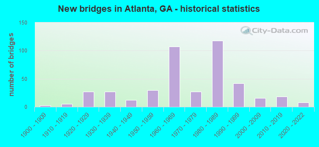
- New bridges - historical statistics
- 31900-1909
- 51910-1919
- 271920-1929
- 271930-1939
- 121940-1949
- 301950-1959
- 1071960-1969
- 271970-1979
- 1181980-1989
- 421990-1999
- 162000-2009
- 182010-2019
- 82020-2022
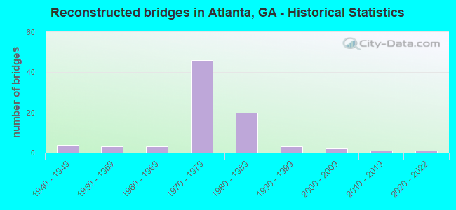
- Reconstructed bridges - Historical Statistics
- 41940-1949
- 31950-1959
- 31960-1969
- 461970-1979
- 201980-1989
- 31990-1999
- 22000-2009
- 12010-2019
- 12020-2022
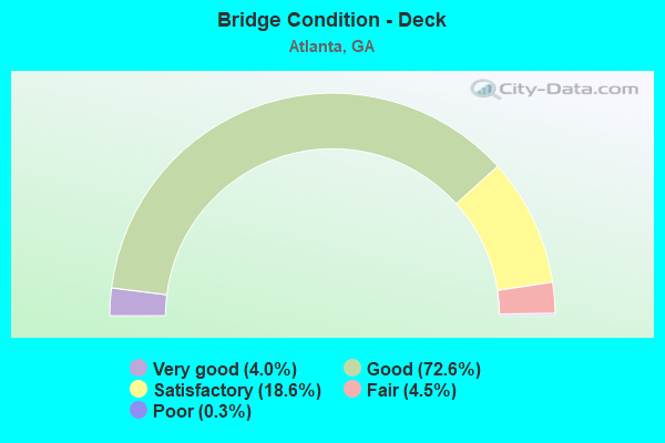
- Bridge Condition - Deck
- 4.0%Very good
- 72.6%Good
- 18.6%Satisfactory
- 4.5%Fair
- 0.3%Poor
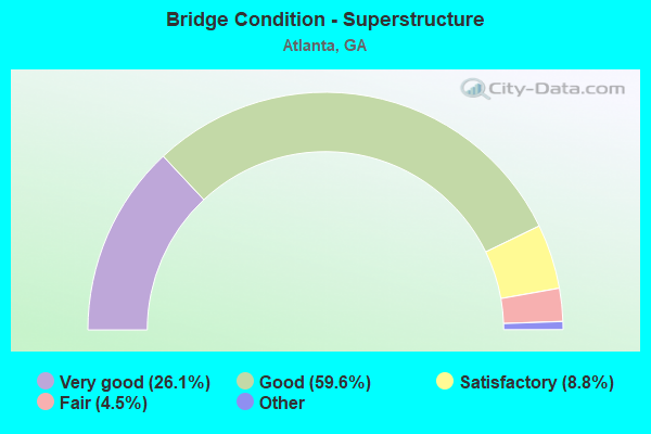
- Bridge Condition - Superstructure
- 26.1%Very good
- 59.6%Good
- 8.8%Satisfactory
- 4.5%Fair
- 1.1%Poor
- 0.3%Imminent failure
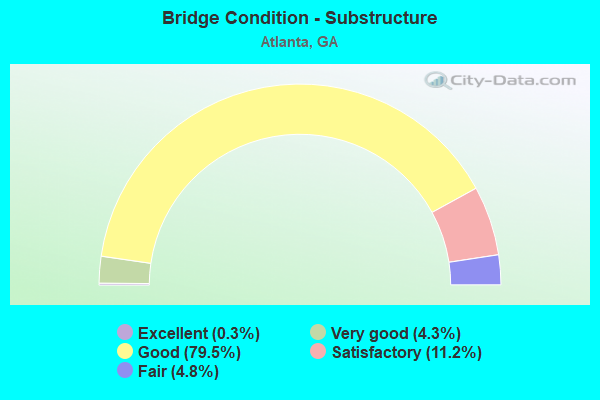
- Bridge Condition - Substructure
- 0.3%Excellent
- 4.3%Very good
- 79.5%Good
- 11.2%Satisfactory
- 4.8%Fair
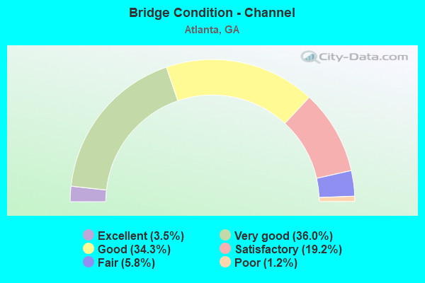
- Bridge Condition - Channel
- 3.5%Excellent
- 36.0%Very good
- 34.3%Good
- 19.2%Satisfactory
- 5.8%Fair
- 1.2%Poor
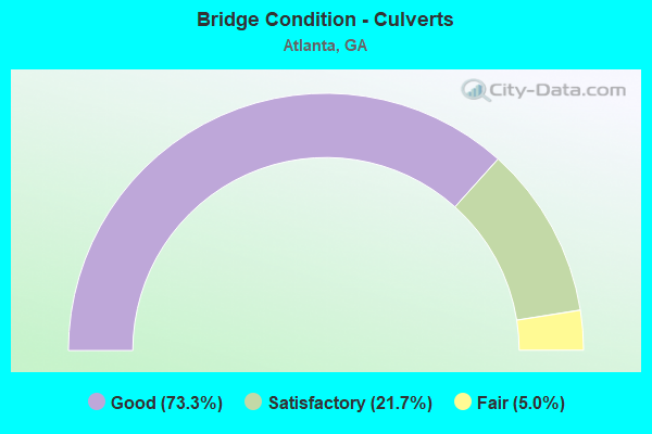
- Bridge Condition - Culverts
- 73.3%Good
- 21.7%Satisfactory
- 5.0%Fair
Find on map >> Show street view
Structure Number: 1210213, Location: IN N ATLANTA (Lat: 33.823528, Lng: -84.353669), Route carried "under" structure: City street 9213, Structure Length: 0. m, Average Daily Traffic: 47,500 (year 1998), Truck Traffic: 1%, Features Intersected: I-85, Facility Carried by Structure: I-85
Minimum Vertical Clearance: 5.53m (18.14ft), Kilometerpoint: 3.219, Lanes on structure: 13, Length of Maximum Span: 0.0m
Find on map >> Show street view
Structure Number: 1210224, Location: IN S W ATLANTA (Lat: 33.673369, Lng: -84.498478), Route carried "under" structure: City street 9056, Structure Length: 0. m, Average Daily Traffic: 11,370 (year 1998), Truck Traffic: 1%, Features Intersected: I-285, Facility Carried by Structure: I-285
Minimum Vertical Clearance: 4.72m (15.49ft), Kilometerpoint: 1.609, Lanes on structure: 8, Length of Maximum Span: 0.0m
Find on map >> Show street view
Structure Number: 1210227, Location: IN S W ATLANTA (Lat: 33.683997, Lng: -84.499789), Route carried "under" structure: City street 9059, Structure Length: 0. m, Average Daily Traffic: 11,370 (year 1998), Truck Traffic: 1%, Features Intersected: I-285, Facility Carried by Structure: I-285
Minimum Vertical Clearance: 4.57m (14.99ft), Kilometerpoint: 0.000, Lanes on structure: 9, Length of Maximum Span: 0.0m
Find on map >> Show street view
Structure Number: 1210229, Location: IN SOUTHWEST ATLANTA (Lat: 33.698300, Lng: -84.499047), Route carried "under" structure: City street 9058, Structure Length: 0. m, Average Daily Traffic: 11,370 (year 1998), Truck Traffic: 1%, Features Intersected: I-285, Facility Carried by Structure: I-285
Minimum Vertical Clearance: 4.97m (16.31ft), Kilometerpoint: 0.000, Lanes on structure: 8, Length of Maximum Span: 0.0m
Find on map >> Show street view
Structure Number: 1210234, Location: IN W ATLANTA (Lat: 33.723039, Lng: -84.502689), Route carried "under" structure: City street 9053, Structure Length: 0. m, Average Daily Traffic: 17,910 (year 1998), Truck Traffic: 1%, Features Intersected: I-285 (SR 407), Facility Carried by Structure: I-285
Minimum Vertical Clearance: 5.25m (17.22ft), Kilometerpoint: 6.437, Lanes on structure: 8, Length of Maximum Span: 0.0m
Find on map >> Show street view
Structure Number: 1210237, Location: IN W ATLANTA (Lat: 33.756256, Lng: -84.494425), Route carried "under" structure: City street 2766, Structure Length: 0. m, Average Daily Traffic: 1,810 (year 1998), Truck Traffic: 1%, Features Intersected: I-285 (SR 407), Facility Carried by Structure: I-285
Minimum Vertical Clearance: 4.77m (15.65ft), Kilometerpoint: 1.609, Lanes on structure: 8, Length of Maximum Span: 0.0m
Find on map >> Show street view
Structure Number: 1210238, Location: IN W ATLANTA (Lat: 33.767839, Lng: -84.494069), Route carried "under" structure: City street 9045, Structure Length: 0. m, Average Daily Traffic: 10,460 (year 1998), Truck Traffic: 1%, Features Intersected: I-285 CBL (SR 407), Facility Carried by Structure: I-285 CBL
Minimum Vertical Clearance: 6.19m (20.31ft), Kilometerpoint: 1.609, Lanes on structure: 5, Length of Maximum Span: 0.0m
Find on map >> Show street view
Structure Number: 1210239, Location: IN W ATLANTA (Lat: 33.767928, Lng: -84.494719), Route carried "under" structure: City street 9045, Structure Length: 0. m, Average Daily Traffic: 10,460 (year 1998), Truck Traffic: 1%, Features Intersected: I-285 CCBL (SR 407), Facility Carried by Structure: I-285 CCBL
Minimum Vertical Clearance: 4.54m (14.90ft), Kilometerpoint: 1.609, Lanes on structure: 4, Length of Maximum Span: 0.0m
Find on map >> Show street view
Structure Number: 1210242, Location: IN W ATLANTA (Lat: 33.809269, Lng: -84.495469), Route carried "under" structure: County highway 1971, Structure Length: 0. m, Average Daily Traffic: 1,000 (year 1990), Truck Traffic: 1%, Features Intersected: I-285 (SR 407), Facility Carried by Structure: I-285
Minimum Vertical Clearance: 4.67m (15.32ft), Kilometerpoint: 3.219, Lanes on structure: 8, Length of Maximum Span: 0.0m
Find on map >> Show street view
Structure Number: 1210252, Location: IN W ATLANTA (Lat: 33.756289, Lng: -84.494878), Route carried "under" structure: City street 2766, Structure Length: 0. m, Average Daily Traffic: 1,810 (year 1998), Truck Traffic: 1%, Features Intersected: I-285 CCB RMP TO SR 139, Facility Carried by Structure: I-285 CCB RMP-SR13
Minimum Vertical Clearance: 4.97m (16.31ft), Kilometerpoint: 1.609, Lanes on structure: 2, Length of Maximum Span: 0.0m
Find on map >> Show street view
Structure Number: 1210253, Location: IN W ATLANTA (Lat: 33.762519, Lng: -84.492619), Route carried "under" structure: Interstate 285, Structure Length: 0. m, Average Daily Traffic: 140,500 (year 1998), Truck Traffic: 1%, Features Intersected: RAMP I-285 CCBL TO I-20
Minimum Vertical Clearance: 5.43m (17.81ft), Kilometerpoint: 16.093, Lanes on structure: 1, Length of Maximum Span: 0.0m
Find on map >> Show street view
Structure Number: 1210254, Location: IN W ATLANTA (Lat: 33.761758, Lng: -84.491258), Route carried "under" structure: Ramp Interstate 20, Structure Length: 0. m, Average Daily Traffic: 7,500 (year 2009), Truck Traffic: 1%, Features Intersected: RMP I-285 CCBL TO I-20 E, Facility Carried by Structure: RMP I-285 CCBL-I-2
Minimum Vertical Clearance: 6.45m (21.16ft), Kilometerpoint: 82.077, Lanes on structure: 1, Length of Maximum Span: 0.0m
Find on map >> Show street view
Structure Number: 1210255, Location: IN W ATLANTA (Lat: 33.766119, Lng: -84.494139), Route carried "under" structure: Interstate 285, Structure Length: 0. m, Average Daily Traffic: 161,000 (year 1998), Truck Traffic: 1%, Features Intersected: RAMP I-285 CBL TO I-20 W
Minimum Vertical Clearance: 5.18m (16.99ft), Kilometerpoint: 17.703, Lanes on structure: 1, Length of Maximum Span: 0.0m
Find on map >> Show street view
Structure Number: 1210311, Location: IN W ATLANTA (Lat: 33.741458, Lng: -84.414100), Route carried "under" structure: Interstate 20, Structure Length: 0. m, Average Daily Traffic: 172,100 (year 1998), Truck Traffic: 1%, Features Intersected: CS 1002 LEE STREET, Facility Carried by Structure: LEE STREET
Minimum Vertical Clearance: 5.02m (16.47ft), Kilometerpoint: 90.123, Lanes on structure: 6, Length of Maximum Span: 0.0m
Find on map >> Show street view
Structure Number: 121032, Location: IN NW ATLANTA (Lat: 33.770819, Lng: -84.399939), Route carried "under" structure: US 78, Structure Length: 0. m, Average Daily Traffic: 21,736 (year 1998), Truck Traffic: 1%, Features Intersected: M-9003 MARIETTA STREET, Facility Carried by Structure: MARIETTA STREET
Minimum Vertical Clearance: 4.97m (16.31ft), Kilometerpoint: 11.265, Lanes on structure: 4, Length of Maximum Span: 0.0m
Find on map >> Show street view
Structure Number: 1210326, Location: IN N ATLANTA (Lat: 33.831828, Lng: -84.426408), Route carried "under" structure: Interstate 75, Structure Length: 0. m, Average Daily Traffic: 215,600 (year 1998), Truck Traffic: 1%, Features Intersected: M-9013 MOORES MILL ROAD, Facility Carried by Structure: MOORES MILL ROAD
Minimum Vertical Clearance: 6.42m (21.06ft), Kilometerpoint: 408.774, Lanes on structure: 4, Length of Maximum Span: 0.0m
Find on map >> Show street view
Structure Number: 1210336, Location: IN W ATLANTA (Lat: 33.759878, Lng: -84.482619), Route carried "under" structure: Interstate 20, Structure Length: 0. m, Average Daily Traffic: 115,900 (year 1998), Truck Traffic: 1%, Features Intersected: M-9050 LINKWOOD ROAD, Facility Carried by Structure: LINKWOOD ROAD
Minimum Vertical Clearance: 5.71m (18.73ft), Kilometerpoint: 82.077, Lanes on structure: 2, Length of Maximum Span: 0.0m
Find on map >> Show street view
Structure Number: 1210337, Location: IN W ATLANTA (Lat: 33.750728, Lng: -84.496592), Route carried "under" structure: Interstate 285, Structure Length: 0. m, Average Daily Traffic: 141,000 (year 1998), Truck Traffic: 1%, Features Intersected: M-9051 BOULDER PARK RD, Facility Carried by Structure: BOULDER PARK RD
Minimum Vertical Clearance: 5.56m (18.24ft), Kilometerpoint: 16.093, Lanes on structure: 2, Length of Maximum Span: 0.0m
Find on map >> Show street view
Structure Number: 1210339, Location: IN W ATLANTA (Lat: 33.738019, Lng: -84.500869), Route carried "under" structure: Interstate 285, Structure Length: 0. m, Average Daily Traffic: 141,000 (year 1998), Truck Traffic: 1%, Features Intersected: M-9052 BENJAMIN MAYS DR., Facility Carried by Structure: BENJAMIN MAYS DR.
Minimum Vertical Clearance: 5.76m (18.90ft), Kilometerpoint: 14.484, Lanes on structure: 2, Length of Maximum Span: 0.0m
Find on map >> Show street view
Structure Number: 1210346, Location: IN W ATLANTA (Lat: 33.766089, Lng: -84.500119), Route carried "under" structure: Interstate 20, Structure Length: 0. m, Average Daily Traffic: 159,400 (year 1998), Truck Traffic: 1%, Features Intersected: M-9054 FAIRBURN ROAD, Facility Carried by Structure: FAIRBURN ROAD
Minimum Vertical Clearance: 6.01m (19.72ft), Kilometerpoint: 80.467, Lanes on structure: 2, Length of Maximum Span: 0.0m
Find on map >> Show street view
Structure Number: 1210349, Location: IN SW ATLANTA (Lat: 33.695097, Lng: -84.486269), Route carried "under" structure: State highway 154, Structure Length: 0. m, Average Daily Traffic: 45,600 (year 1998), Truck Traffic: 1%, Features Intersected: M-9057 CHILDRESS DRIVE, Facility Carried by Structure: CHILDRESS DRIVE
Minimum Vertical Clearance: 5.15m (16.90ft), Kilometerpoint: 37.015, Lanes on structure: 2, Length of Maximum Span: 0.0m
Find on map >> Show street view
Structure Number: 1210352, Location: IN S W ATLANTA (Lat: 33.692050, Lng: -84.490125), Route carried "under" structure: State highway 154, Structure Length: 0. m, Average Daily Traffic: 49,017 (year 1998), Truck Traffic: 1%, Features Intersected: M-9060 GILEAD ROAD, Facility Carried by Structure: GILEAD ROAD
Minimum Vertical Clearance: 5.25m (17.22ft), Kilometerpoint: 37.015, Lanes on structure: 5, Length of Maximum Span: 0.0m
Find on map >> Show street view
Structure Number: 1210359, Location: IN ATLANTA (Lat: 33.756178, Lng: -84.396869), Route carried "under" structure: City street 9161, Structure Length: 0. m, Average Daily Traffic: 11,370 (year 1999), Truck Traffic: 1%, Features Intersected: M-9073 TECHWOOD DRIVE, Facility Carried by Structure: CEN OLYMPIC PARK D
Minimum Vertical Clearance: 5.35m (17.55ft), Kilometerpoint: 0.000, Lanes on structure: 5, Length of Maximum Span: 0.0m
Find on map >> Show street view
Structure Number: 121036, Location: IN ATLANTA (Lat: 33.766928, Lng: -84.388097), Route carried "under" structure: Interstate 75, Structure Length: 0. m, Average Daily Traffic: 288,200 (year 1998), Truck Traffic: 1%, Features Intersected: M-9073 SPRING STREET, Facility Carried by Structure: SPRING STREET
Minimum Vertical Clearance: 9.14m (29.99ft), Kilometerpoint: 399.118, Lanes on structure: 4, Length of Maximum Span: 0.0m
Find on map >> Show street view
Structure Number: 1210374, Location: 1 MI NE OF HAPEVILLE (Lat: 33.681147, Lng: -84.398497), Route carried "under" structure: Ramp Interstate 75, Structure Length: 0. m, Average Daily Traffic: 15,100 (year 1995), Truck Traffic: 1%, Features Intersected: M-9082 CLEVELAND AVE., Facility Carried by Structure: CLEVELAND AVE.
Minimum Vertical Clearance: 5.99m (19.65ft), Kilometerpoint: 389.461, Lanes on structure: 6, Length of Maximum Span: 0.0m
Find on map >> Show street view
Structure Number: 1210374, Location: 1 MI NE OF HAPEVILLE (Lat: 33.681147, Lng: -84.398497), Route carried "under" structure: Interstate 75, Structure Length: 0. m, Average Daily Traffic: 156,500 (year 1998), Truck Traffic: 1%, Features Intersected: M-9082 CLEVELAND AVE, Facility Carried by Structure: CLEVELAND AVE.
Minimum Vertical Clearance: 5.43m (17.81ft), Kilometerpoint: 389.461, Lanes on structure: 6, Length of Maximum Span: 0.0m
Find on map >> Show street view
Structure Number: 1210378, Location: SOUTH ATLANTA (Lat: 33.661481, Lng: -84.355728), Route carried "under" structure: Interstate 285, Structure Length: 0. m, Average Daily Traffic: 115,900 (year 1999), Truck Traffic: 1%, Features Intersected: M-9093 FORREST PARK RD, Facility Carried by Structure: FORREST PARK RD
Minimum Vertical Clearance: 5.28m (17.32ft), Kilometerpoint: 86.905, Lanes on structure: 2, Length of Maximum Span: 0.0m
Find on map >> Show street view
Structure Number: 1210388, Location: IN ATLANTA (Lat: 33.733350, Lng: -84.423450), Route carried "under" structure: City street 9131, Structure Length: 0. m, Average Daily Traffic: 11,370 (year 1999), Truck Traffic: 1%, Features Intersected: M-9130 LAWTON STREET, Facility Carried by Structure: LAWTON STREET
Minimum Vertical Clearance: 5.15m (16.90ft), Kilometerpoint: 4.828, Lanes on structure: 4, Length of Maximum Span: 0.0m
Find on map >> Show street view
Structure Number: 1210389, Location: IN W ATLANTA (Lat: 33.747489, Lng: -84.438919), Route carried "under" structure: Interstate 20, Structure Length: 0. m, Average Daily Traffic: 128,800 (year 1999), Truck Traffic: 1%, Features Intersected: M-9133 WESTVIEW DRIVE, Facility Carried by Structure: WESTVIEW DRIVE
Minimum Vertical Clearance: 5.08m (16.67ft), Kilometerpoint: 86.905, Lanes on structure: 2, Length of Maximum Span: 0.0m
Find on map >> Show street view
Structure Number: 121039, Location: IN WEST ATLANTA (Lat: 33.747308, Lng: -84.429828), Route carried "under" structure: City street 9131, Structure Length: 0. m, Average Daily Traffic: 16,057 (year 1999), Truck Traffic: 1%, Features Intersected: M-9133 WESTVIEW DRIVE, Facility Carried by Structure: WESTVIEW DRIVE
Minimum Vertical Clearance: 6.95m (22.80ft), Kilometerpoint: 0.000, Lanes on structure: 3, Length of Maximum Span: 0.0m
Find on map >> Show street view
Structure Number: 1210391, Location: IN ATLANTA (Lat: 33.754558, Lng: -84.396969), Route carried "under" structure: City street 3435, Structure Length: 0. m, Average Daily Traffic: 4,000 (year 1999), Truck Traffic: 1%, Features Intersected: M-9134 M.L.K. JR. DRIVE, Facility Carried by Structure: M.L.K. JR. DRIVE
Minimum Vertical Clearance: 7.44m (24.41ft), Kilometerpoint: 0.000, Lanes on structure: 5, Length of Maximum Span: 0.0m
Find on map >> Show street view
Structure Number: 1210402, Location: IN N ATLANTA (Lat: 33.805258, Lng: -84.413269), Route carried "under" structure: Interstate 75, Structure Length: 0. m, Average Daily Traffic: 220,300 (year 1998), Truck Traffic: 1%, Features Intersected: M-9143 HOWELL MILL ROAD, Facility Carried by Structure: HOWELL MILL ROAD
Minimum Vertical Clearance: 5.81m (19.06ft), Kilometerpoint: 405.555, Lanes on structure: 6, Length of Maximum Span: 0.0m
Find on map >> Show street view
Structure Number: 1210402, Location: IN N ATLANTA (Lat: 33.805258, Lng: -84.413269), Route carried "under" structure: Ramp Interstate 75, Structure Length: 0. m, Average Daily Traffic: 11,000 (year 1995), Truck Traffic: 1%, Features Intersected: M-9143 HOWELL MILL ROAD, Facility Carried by Structure: HOWELL MILL ROAD
Minimum Vertical Clearance: 5.41m (17.75ft), Kilometerpoint: 405.555, Lanes on structure: 6, Length of Maximum Span: 0.0m
Find on map >> Show street view
Structure Number: 1210405, Location: IN N ATLANTA (Lat: 33.797497, Lng: -84.395250), Route carried "under" structure: Interstate 75, Structure Length: 0. m, Average Daily Traffic: 244,900 (year 1998), Truck Traffic: 1%, Features Intersected: M-9146 DEERING ROAD, Facility Carried by Structure: DEERING ROAD
Minimum Vertical Clearance: 6.78m (22.24ft), Kilometerpoint: 403.946, Lanes on structure: 2, Length of Maximum Span: 0.0m
Find on map >> Show street view
Structure Number: 1210405, Location: IN N ATLANTA (Lat: 33.797497, Lng: -84.395250), Route carried "under" structure: Ramp Interstate 85, Structure Length: 0. m, Average Daily Traffic: 12,000 (year 1990), Truck Traffic: 1%, Features Intersected: M-9146 DEERING ROAD, Facility Carried by Structure: DEERING ROAD
Minimum Vertical Clearance: 5.35m (17.55ft), Kilometerpoint: 136.794, Lanes on structure: 2, Length of Maximum Span: 0.0m
Find on map >> Show street view
Structure Number: 1210407, Location: IN ATLANTA (Lat: 33.781550, Lng: -84.391039), Route carried "under" structure: Interstate 75, Structure Length: 0. m, Average Daily Traffic: 413,400 (year 1998), Truck Traffic: 1%, Features Intersected: M-9149 TENTH STREET, Facility Carried by Structure: TENTH STREET
Minimum Vertical Clearance: 6.57m (21.56ft), Kilometerpoint: 402.336, Lanes on structure: 7, Length of Maximum Span: 0.0m
Find on map >> Show street view
Structure Number: 121041, Location: IN ATLANTA (Lat: 33.751500, Lng: -84.371078), Route carried "under" structure: City street 9180, Structure Length: 0. m, Average Daily Traffic: 16,600 (year 1999), Truck Traffic: 1%, Features Intersected: CS 1790 DECATUR STREET, Facility Carried by Structure: DECATUR STREET
Minimum Vertical Clearance: 4.26m (13.98ft), Kilometerpoint: 4.828, Lanes on structure: 3, Length of Maximum Span: 0.0m
Find on map >> Show street view
Structure Number: 1210414, Location: CIVIC CENTER STATION (Lat: 33.766478, Lng: -84.387489), Route carried "under" structure: Interstate 75, Structure Length: 0. m, Average Daily Traffic: 405,300 (year 1999), Truck Traffic: 1%, Features Intersected: M-9158 W. P'TREE STREET, Facility Carried by Structure: W. P'TREE- MARTA
Minimum Vertical Clearance: 5.48m (17.98ft), Kilometerpoint: 399.118, Lanes on structure: 5, Length of Maximum Span: 0.0m
Find on map >> Show street view
Structure Number: 1210416, Location: IN ATLANTA (Lat: 33.746369, Lng: -84.391358), Route carried "under" structure: Ramp Interstate 75, Structure Length: 0. m, Average Daily Traffic: 10,000 (year 1996), Truck Traffic: 1%, Features Intersected: M-9163 WASHINGTON ST, Facility Carried by Structure: WASHINGTON STREET
Minimum Vertical Clearance: 6.29m (20.64ft), Kilometerpoint: 395.899, Lanes on structure: 4, Length of Maximum Span: 0.0m
Find on map >> Show street view
Structure Number: 1210416, Location: IN ATLANTA (Lat: 33.746369, Lng: -84.391358), Route carried "under" structure: Ramp Interstate 75, Structure Length: 0. m, Average Daily Traffic: 17,150 (year 1999), Truck Traffic: 1%, Features Intersected: M-9163 WASHINGTON ST, Facility Carried by Structure: WASHINGTON STREET
Minimum Vertical Clearance: 5.99m (19.65ft), Kilometerpoint: 395.899, Lanes on structure: 4, Length of Maximum Span: 0.0m
Find on map >> Show street view
Structure Number: 1210422, Location: IN SOUTH ATLANTA (Lat: 33.698058, Lng: -84.399000), Route carried "under" structure: State highway 166, Structure Length: 0. m, Average Daily Traffic: 20,979 (year 1998), Truck Traffic: 1%, Features Intersected: M-9086 PRYOR ROAD, Facility Carried by Structure: PRYOR ROAD
Minimum Vertical Clearance: 5.74m (18.83ft), Kilometerpoint: 24.140, Lanes on structure: 2, Length of Maximum Span: 0.0m
Find on map >> Show street view
Structure Number: 1210424, Location: IN E ATLANTA (Lat: 33.743369, Lng: -84.368128), Route carried "under" structure: Interstate 20, Structure Length: 0. m, Average Daily Traffic: 159,000 (year 1998), Truck Traffic: 1%, Features Intersected: M-9180 BOULEVARD, Facility Carried by Structure: BOULEVARD
Minimum Vertical Clearance: 5.30m (17.39ft), Kilometerpoint: 93.342, Lanes on structure: 5, Length of Maximum Span: 0.0m
Find on map >> Show street view
Structure Number: 1210429, Location: IN ATLANTA (Lat: 33.760119, Lng: -84.374278), Route carried "under" structure: State highway 10, Structure Length: 0. m, Average Daily Traffic: 42,900 (year 1998), Truck Traffic: 1%, Features Intersected: M-9190 JACKSON STREET, Facility Carried by Structure: JACKSON STREET
Minimum Vertical Clearance: 5.94m (19.49ft), Kilometerpoint: 0.000, Lanes on structure: 4, Length of Maximum Span: 0.0m
Find on map >> Show street view
Structure Number: 1210431, Location: RM FR WILLIAMS ST TO I75 (Lat: 33.768200, Lng: -84.389528), Route carried "under" structure: Interstate 75, Structure Length: 0. m, Average Daily Traffic: 405,300 (year 1998), Truck Traffic: 1%, Features Intersected: RMP WILLIAMS ST TO I-75N, Facility Carried by Structure: IN ATLANTA
Minimum Vertical Clearance: 10.99m (36.06ft), Kilometerpoint: 400.727, Lanes on structure: 1, Length of Maximum Span: 0.0m
Find on map >> Show street view
Structure Number: 1210441, Location: IN N FULTON (Lat: 33.825961, Lng: -84.424228), Route carried "under" structure: Interstate 75, Structure Length: 0. m, Average Daily Traffic: 220,300 (year 1998), Truck Traffic: 1%, Features Intersected: M-9210 P'TREE BATTLE AVE, Facility Carried by Structure: P'TREE BATTLE AVE
Minimum Vertical Clearance: 7.92m (25.98ft), Kilometerpoint: 408.774, Lanes on structure: 2, Length of Maximum Span: 0.0m
Find on map >> Show street view
Structure Number: 121047, Location: IN NW ATLANTA (Lat: 33.770400, Lng: -84.400808), Route carried "under" structure: US 78, Structure Length: 0. m, Average Daily Traffic: 21,736 (year 1998), Truck Traffic: 1%, Features Intersected: NORTH AVENUE, Facility Carried by Structure: NORFOLK SOUTHERN R
Minimum Vertical Clearance: 5.91m (19.39ft), Kilometerpoint: 0.000, Lanes on structure: 2, Length of Maximum Span: 0.0m
Find on map >> Show street view
Structure Number: 1210473, Location: IN ATLANTA (Lat: 33.758008, Lng: -84.397069), Route carried "under" structure: City street 9315, Structure Length: 0. m, Average Daily Traffic: 11,370 (year 1999), Truck Traffic: 1%, Features Intersected: CS 20065 ACCESS TO OMNI, Facility Carried by Structure: SERVICE RD PARKING
Minimum Vertical Clearance: 5.28m (17.32ft), Kilometerpoint: 0.000, Lanes on structure: 1, Length of Maximum Span: 0.0m
Find on map >> Show street view
Structure Number: 1210474, Location: IN ATLANTA (Lat: 33.757608, Lng: -84.399169), Route carried "under" structure: City street 3435, Structure Length: 0. m, Average Daily Traffic: 11,370 (year 1999), Truck Traffic: 1%, Features Intersected: MANGUM ST SW, Facility Carried by Structure: A. YOUNG INTL BLVD
Minimum Vertical Clearance: 4.90m (16.08ft), Kilometerpoint: 0.000, Lanes on structure: 4, Length of Maximum Span: 0.0m
Find on map >> Show street view
Structure Number: 121048, Location: IN ATLANTA (Lat: 33.726250, Lng: -84.393769), Route carried "under" structure: Interstate 75, Structure Length: 0. m, Average Daily Traffic: 283,540 (year 2012), Truck Traffic: 1%, Features Intersected: I-75, Facility Carried by Structure: NORFOLK SOUTHERN R
Minimum Vertical Clearance: 6.12m (20.08ft), Kilometerpoint: 394.289, Length of Maximum Span: 0.0m
Find on map >> Show street view
Structure Number: 1210482, Location: IN ATLANTA (Lat: 33.796858, Lng: -84.394597), Route carried "under" structure: Interstate 75, Structure Length: 0. m, Average Daily Traffic: 132,760 (year 2012), Truck Traffic: 1%, Features Intersected: I-75, Facility Carried by Structure: NORFOLK SOUTHERN R
Minimum Vertical Clearance: 8.66m (28.41ft), Kilometerpoint: 403.946, Length of Maximum Span: 0.0m
Find on map >> Show street view
Structure Number: 1210482, Location: IN ATLANTA (Lat: 33.796858, Lng: -84.394597), Route carried "under" structure: Ramp Interstate 75, Structure Length: 0. m, Average Daily Traffic: 132,760 (year 2012), Truck Traffic: 1%, Features Intersected: N/S RAILROAD, Facility Carried by Structure: NORFOLK SOUTHERN R
Minimum Vertical Clearance: 5.15m (16.90ft), Kilometerpoint: 403.946, Length of Maximum Span: 0.0m
Find on map >> Show street view
Structure Number: 1210483, Location: IN ATLANTA (Lat: 33.797289, Lng: -84.395158), Route carried "under" structure: Interstate 75, Structure Length: 0. m, Average Daily Traffic: 132,760 (year 2012), Truck Traffic: 1%, Features Intersected: I-75, Facility Carried by Structure: NOR SOUTHERN RR
Minimum Vertical Clearance: 9.14m (29.99ft), Kilometerpoint: 403.946, Length of Maximum Span: 0.0m
Find on map >> Show street view
Structure Number: 1210487, Location: IN N ATLANTA (Lat: 33.807019, Lng: -84.378289), Route carried "under" structure: State highway 13, Structure Length: 0. m, Average Daily Traffic: 78,970 (year 2012), Truck Traffic: 2%, Features Intersected: SR 13, Facility Carried by Structure: NORFOLK SOUTHERN R
Minimum Vertical Clearance: 5.00m (16.40ft), Kilometerpoint: 3.219, Length of Maximum Span: 0.0m
Find on map >> Show street view
Structure Number: 1210488, Location: IN N ATLANTA (Lat: 33.807608, Lng: -84.377489), Route carried "under" structure: State highway 13, Structure Length: 0. m, Average Daily Traffic: 30,510 (year 2012), Truck Traffic: 1%, Features Intersected: SR 13, Facility Carried by Structure: ATLANTA BELTLINE
Minimum Vertical Clearance: 4.54m (14.90ft), Kilometerpoint: 3.219, Length of Maximum Span: 0.0m
Find on map >> Show street view
Structure Number: 1210489, Location: IN SOUTHWEST ATLANTA (Lat: 33.690242, Lng: -84.500067), Route carried "under" structure: Interstate 285, Structure Length: 0. m, Average Daily Traffic: 137,730 (year 2012), Truck Traffic: 1%, Features Intersected: I-285, Facility Carried by Structure: UTILITY BRIDGE
Minimum Vertical Clearance: 5.56m (18.24ft), Kilometerpoint: 8.047, Length of Maximum Span: 0.0m
Find on map >> Show street view
Structure Number: 121049, Location: IN W ATLANTA (Lat: 33.751069, Lng: -84.496508), Route carried "under" structure: Interstate 285, Structure Length: 0. m, Average Daily Traffic: 142,200 (year 2012), Truck Traffic: 1%, Features Intersected: I-285 (SR 407), Facility Carried by Structure: CSX RAILROAD
Minimum Vertical Clearance: 5.25m (17.22ft), Kilometerpoint: 16.093, Length of Maximum Span: 0.0m
Find on map >> Show street view
Structure Number: 1210491, Location: IN ATLANTA (Lat: 33.773339, Lng: -84.364578), Route carried "under" structure: US 29, Structure Length: 0. m, Average Daily Traffic: 34,020 (year 2011), Truck Traffic: 1%, Features Intersected: SR 8 PONCE DE LEON, Facility Carried by Structure: PED. BRIDGE
Minimum Vertical Clearance: 30+ m (98+ ft), Kilometerpoint: 14.484, Length of Maximum Span: 0.0m
Find on map >> Show street view
Structure Number: 1210492, Location: IN N ATLANTA (Lat: 33.788608, Lng: -84.407658), Route carried "under" structure: US 41, Structure Length: 0. m, Average Daily Traffic: 25,490 (year 2012), Truck Traffic: 1%, Features Intersected: SR 3 NORTHSIDE DRIVE, Facility Carried by Structure: NORFOLK SOUTHERN R
Minimum Vertical Clearance: 4.67m (15.32ft), Kilometerpoint: 17.703, Length of Maximum Span: 0.0m
Find on map >> Show street view
Structure Number: 1210493, Location: IN N ATLANTA (Lat: 33.798689, Lng: -84.407839), Route carried "under" structure: US 41, Structure Length: 0. m, Average Daily Traffic: 28,750 (year 2010), Truck Traffic: 1%, Features Intersected: SR 3 NORTHSIDE DRIVE, Facility Carried by Structure: CSX RAILROAD
Minimum Vertical Clearance: 4.74m (15.55ft), Kilometerpoint: 17.703, Length of Maximum Span: 0.0m
Find on map >> Show street view
Structure Number: 1210494, Location: IN W ATLANTA (Lat: 33.743042, Lng: -84.408239), Route carried "under" structure: US 41, Structure Length: 0. m, Average Daily Traffic: 6,800 (year 2012), Truck Traffic: 4%, Features Intersected: SR 3 NORTHSIDE DRIVE, Facility Carried by Structure: CSX RAILROAD
Minimum Vertical Clearance: 4.62m (15.16ft), Kilometerpoint: 11.265, Length of Maximum Span: 0.0m
Find on map >> Show street view
Structure Number: 1210496, Location: IN ATLANTA (Lat: 33.770608, Lng: -84.400489), Route carried "under" structure: US 78, Structure Length: 0. m, Average Daily Traffic: 10,810 (year 2012), Truck Traffic: 1%, Features Intersected: SR 8 NORTH AVENUE, Facility Carried by Structure: NORFOLK SOUTHERN R
Minimum Vertical Clearance: 4.59m (15.06ft), Kilometerpoint: 11.265, Length of Maximum Span: 0.0m
Find on map >> Show street view
Structure Number: 1210497, Location: IN ATLANTA (Lat: 33.770339, Lng: -84.401008), Route carried "under" structure: US 78, Structure Length: 0. m, Average Daily Traffic: 10,810 (year 2012), Truck Traffic: 1%, Features Intersected: SR 8 NORTH AVENUE, Facility Carried by Structure: NORFOLK SOUTHERN R
Minimum Vertical Clearance: 4.62m (15.16ft), Kilometerpoint: 11.265, Length of Maximum Span: 0.0m
Find on map >> Show street view
Structure Number: 1210498, Location: IN ATLANTA (Lat: 33.770258, Lng: -84.401228), Route carried "under" structure: US 78, Structure Length: 0. m, Average Daily Traffic: 10,810 (year 2012), Truck Traffic: 1%, Features Intersected: SR 8 NORTH AVENUE, Facility Carried by Structure: NORFOLK SOUTHERN R
Minimum Vertical Clearance: 4.67m (15.32ft), Kilometerpoint: 11.265, Length of Maximum Span: 0.0m
Find on map >> Show street view
Structure Number: 1210501, Location: IN CITY OF ATLANTA (Lat: 33.818278, Lng: -84.463097), Route carried "under" structure: City street 9013, Structure Length: 0. m, Average Daily Traffic: 14,580 (year 2011), Truck Traffic: 1%, Features Intersected: M-9013 BOLTON ROAD, Facility Carried by Structure: CSX RAILROAD
Minimum Vertical Clearance: 4.24m (13.91ft), Kilometerpoint: 8.047, Length of Maximum Span: 0.0m
Find on map >> Show street view
Structure Number: 1210503, Location: IN W ATLANTA (Lat: 33.751528, Lng: -84.490708), Route carried "under" structure: State highway 139, Structure Length: 0. m, Average Daily Traffic: 18,120 (year 2012), Truck Traffic: 1%, Features Intersected: SR 139 M.L.K. JR. DRIVE, Facility Carried by Structure: CSX RAILROAD
Minimum Vertical Clearance: 5.76m (18.90ft), Kilometerpoint: 20.921, Length of Maximum Span: 0.0m
Find on map >> Show street view
Structure Number: 1210507, Location: IN ATLANTA (Lat: 33.820950, Lng: -84.372669), Route carried "under" structure: City street 9215, Structure Length: 0. m, Average Daily Traffic: 14,120 (year 2007), Truck Traffic: 1%, Features Intersected: M-9215 LINDBERGH DRIVE, Facility Carried by Structure: NOR SOU RR (717914
Minimum Vertical Clearance: 4.26m (13.98ft), Kilometerpoint: 1.609, Length of Maximum Span: 0.0m
Find on map >> Show street view
Structure Number: 1210508, Location: IN N ATLANTA (Lat: 33.828447, Lng: -84.367428), Route carried "under" structure: State highway 237, Structure Length: 0. m, Average Daily Traffic: 37,390 (year 2012), Truck Traffic: 1%, Features Intersected: SR 237 PIEDMONT ROAD, Facility Carried by Structure: NORFOLK SOUTHERN R
Minimum Vertical Clearance: 4.80m (15.75ft), Kilometerpoint: 1.609, Length of Maximum Span: 0.0m
Find on map >> Show street view
Structure Number: 1210509, Location: IN W ATLANTA (Lat: 33.754828, Lng: -84.467797), Route carried "under" structure: State highway 280, Structure Length: 0. m, Average Daily Traffic: 13,770 (year 2012), Truck Traffic: 4%, Features Intersected: SR 280 HIGHTOWER ROAD, Facility Carried by Structure: CSX RAILROAD
Minimum Vertical Clearance: 5.61m (18.41ft), Kilometerpoint: 0.000, Length of Maximum Span: 0.0m
Find on map >> Show street view
Structure Number: 121051, Location: FAIRBURN CITY LIMITS (Lat: 33.567150, Lng: -84.580208), Route carried "under" structure: City street 9379, Structure Length: 0. m, Average Daily Traffic: 1,940 (year 2011), Truck Traffic: 1%, Features Intersected: M-9379 COLE STREET, Facility Carried by Structure: CSX RR (50386L)
Minimum Vertical Clearance: 3.02m (9.91ft), Kilometerpoint: 6.437, Length of Maximum Span: 0.0m
Find on map >> Show street view
Structure Number: 1210512, Location: IN CITY OF ATLANTA (Lat: 33.750478, Lng: -84.386397), Route carried "under" structure: City street 9007, Structure Length: 0. m, Average Daily Traffic: 6,710 (year 2011), Truck Traffic: 3%, Features Intersected: M-9007 PIEDMONT AVE., Facility Carried by Structure: MARTA
Minimum Vertical Clearance: 5.33m (17.49ft), Kilometerpoint: 3.219, Length of Maximum Span: 0.0m
Find on map >> Show street view
Structure Number: 1210513, Location: IN CITY OF ATLANTA (Lat: 33.750619, Lng: -84.386250), Route carried "under" structure: City street 9007, Structure Length: 0. m, Average Daily Traffic: 6,710 (year 2011), Truck Traffic: 3%, Features Intersected: M-9007 PIEDMONT AVE., Facility Carried by Structure: CSX RAILROAD
Minimum Vertical Clearance: 4.97m (16.31ft), Kilometerpoint: 3.219, Length of Maximum Span: 0.0m
Find on map >> Show street view
Structure Number: 1210515, Location: IN EAST ATLANTA (Lat: 33.767428, Lng: -84.360900), Route carried "under" structure: City street 9045, Structure Length: 0. m, Average Daily Traffic: 6,620 (year 2011), Truck Traffic: 1%, Features Intersected: M-9045 RALPH McGILL BLVD, Facility Carried by Structure: NOR SOU RR (717935
Minimum Vertical Clearance: 4.29m (14.07ft), Kilometerpoint: 14.484, Length of Maximum Span: 0.0m
Find on map >> Show street view
Structure Number: 1210516, Location: IN WEST END (Lat: 33.738239, Lng: -84.412578), Route carried "under" structure: City street 9053, Structure Length: 0. m, Average Daily Traffic: 10,460 (year 2011), Truck Traffic: 1%, Features Intersected: M-9053RALPH DAVID BLVD, Facility Carried by Structure: NOR SOU RR (718077
Minimum Vertical Clearance: 4.31m (14.14ft), Kilometerpoint: 16.093, Length of Maximum Span: 0.0m
Find on map >> Show street view
Structure Number: 1210517, Location: IN ATLANTA (Lat: 33.736789, Lng: -84.403778), Route carried "under" structure: City street 9053, Structure Length: 0. m, Average Daily Traffic: 8,330 (year 2011), Truck Traffic: 1%, Features Intersected: M-9053RALPH DAVID BLVD, Facility Carried by Structure: NOR SOU RR (718054
Minimum Vertical Clearance: 4.26m (13.98ft), Kilometerpoint: 17.703, Length of Maximum Span: 0.0m
Find on map >> Show street view
Structure Number: 1210518, Location: IN EAST POINT (Lat: 33.667158, Lng: -84.428369), Route carried "under" structure: City street 9064, Structure Length: 0. m, Average Daily Traffic: 6,800 (year 2007), Truck Traffic: 1%, Features Intersected: M-9064 NORMAN BERRY RD, Facility Carried by Structure: NOR SOU RR (718012
Minimum Vertical Clearance: 5.35m (17.55ft), Kilometerpoint: 1.609, Length of Maximum Span: 0.0m
Find on map >> Show street view
Structure Number: 1210519, Location: IN CITY OF ATLANTA (Lat: 33.670239, Lng: -84.443258), Route carried "under" structure: City street 9080, Structure Length: 0. m, Average Daily Traffic: 5,140 (year 2011), Truck Traffic: 6%, Features Intersected: M-9080 WILLINGHAM DRIVE, Facility Carried by Structure: CSX RR (50347V)
Minimum Vertical Clearance: 5.20m (17.06ft), Kilometerpoint: 0.000, Length of Maximum Span: 0.0m
Find on map >> Show street view
Structure Number: 121052, Location: IN ATLANTA (Lat: 33.753547, Lng: -84.426031), Route carried "under" structure: City street 9134, Structure Length: 0. m, Average Daily Traffic: 9,220 (year 2007), Truck Traffic: 1%, Features Intersected: M-9134 M.L.K. JR DRIVE, Facility Carried by Structure: PEDESTRIAN: ATLANT
Minimum Vertical Clearance: 6.01m (19.72ft), Kilometerpoint: 1.609, Length of Maximum Span: 0.0m
Find on map >> Show street view
Structure Number: 1210521, Location: IN ATLANTA (Lat: 33.754728, Lng: -84.408419), Route carried "under" structure: City street 9134, Structure Length: 0. m, Average Daily Traffic: 9,220 (year 2007), Truck Traffic: 1%, Features Intersected: M-9134 M.L.K. JR DRIVE, Facility Carried by Structure: PED. OVERPASS
Minimum Vertical Clearance: 6.24m (20.47ft), Kilometerpoint: 3.219, Length of Maximum Span: 0.0m
Find on map >> Show street view
Structure Number: 1210522, Location: IN CITY OF ATLANTA (Lat: 33.724339, Lng: -84.378558), Route carried "under" structure: City street 9165, Structure Length: 0. m, Average Daily Traffic: 2,400 (year 2011), Truck Traffic: 1%, Features Intersected: M-9165 HILL STREET, Facility Carried by Structure: CSX RR (50311M)
Minimum Vertical Clearance: 4.90m (16.08ft), Kilometerpoint: 1.609, Length of Maximum Span: 0.0m
Find on map >> Show street view
Structure Number: 1210523, Location: IN ATLANTA (Lat: 33.748778, Lng: -84.379528), Route carried "under" structure: City street 9165, Structure Length: 0. m, Average Daily Traffic: 1,940 (year 2011), Truck Traffic: 1%, Features Intersected: M-9165 HILL STREET, Facility Carried by Structure: CSX RR (279969K)
Minimum Vertical Clearance: 4.21m (13.81ft), Kilometerpoint: 3.219, Length of Maximum Span: 0.0m
Find on map >> Show street view
Structure Number: 1210524, Location: IN ATLANTA (Lat: 33.725700, Lng: -84.393189), Route carried "under" structure: City street 9086, Structure Length: 0. m, Average Daily Traffic: 10,390 (year 2011), Truck Traffic: 1%, Features Intersected: M-9086 PRYOR STREET, Facility Carried by Structure: NOR SOU RR (718059
Minimum Vertical Clearance: 5.48m (17.98ft), Kilometerpoint: 3.219, Length of Maximum Span: 0.0m
Find on map >> Show street view
Structure Number: 1210525, Location: IN ATLANTA (Lat: 33.719489, Lng: -84.393369), Route carried "under" structure: City street 9086, Structure Length: 0. m, Average Daily Traffic: 10,240 (year 2011), Truck Traffic: 1%, Features Intersected: M-9086 PRYOR ROAD, Facility Carried by Structure: CSX RR (50314H)
Minimum Vertical Clearance: 5.79m (19.00ft), Kilometerpoint: 3.219, Length of Maximum Span: 0.0m
Find on map >> Show street view
Structure Number: 1210527, Location: IN CITY OF ATLANTA (Lat: 33.751300, Lng: -84.370978), Route carried "under" structure: City street 9180, Structure Length: 0. m, Average Daily Traffic: 15,320 (year 2011), Truck Traffic: 5%, Features Intersected: M-9180 BOULEVARD, Facility Carried by Structure: CSX RR- PRIVATE DR
Minimum Vertical Clearance: 4.19m (13.75ft), Kilometerpoint: 4.828, Length of Maximum Span: 0.0m
Find on map >> Show street view
Structure Number: 1210528, Location: IN CITY OF ATLANTA (Lat: 33.733708, Lng: -84.360208), Route carried "under" structure: City street 9182, Structure Length: 0. m, Average Daily Traffic: 1,840 (year 2011), Truck Traffic: 1%, Features Intersected: M-9182 ORMEWOOD AVE., Facility Carried by Structure: CSX RR (50308E)
Minimum Vertical Clearance: 8.89m (29.17ft), Kilometerpoint: 1.609, Length of Maximum Span: 0.0m
Find on map >> Show street view
Structure Number: 1210529, Location: IN ATLANTA (Lat: 33.771108, Lng: -84.363969), Route carried "under" structure: City street 9189, Structure Length: 0. m, Average Daily Traffic: 10,780 (year 2011), Truck Traffic: 1%, Features Intersected: M-9189 NORTH AVE., Facility Carried by Structure: NOR SOU RR (718035
Minimum Vertical Clearance: 5.56m (18.24ft), Kilometerpoint: 1.609, Length of Maximum Span: 0.0m
Find on map >> Show street view
Structure Number: 121053, Location: IN ATLANTA (Lat: 33.771128, Lng: -84.363739), Route carried "under" structure: City street 9189, Structure Length: 0. m, Average Daily Traffic: 10,780 (year 2011), Truck Traffic: 1%, Features Intersected: M-9189 NORTH AVE., Facility Carried by Structure: NOR SOU RR SPUR
Minimum Vertical Clearance: 4.44m (14.57ft), Kilometerpoint: 1.609, Length of Maximum Span: 0.0m
Find on map >> Show street view
Structure Number: 1210531, Location: IN CITY OF ATLANTA (Lat: 33.811619, Lng: -84.431128), Route carried "under" structure: City street 9205, Structure Length: 0. m, Average Daily Traffic: 6,970 (year 2011), Truck Traffic: 1%, Features Intersected: M-9205 COLLIER ROAD, Facility Carried by Structure: CSX RR (639131X)
Minimum Vertical Clearance: 30+ m (98+ ft), Kilometerpoint: 0.000, Length of Maximum Span: 0.0m
Find on map >> Show street view
Structure Number: 1210532, Location: IN CITY OFATLANTA (Lat: 33.821397, Lng: -84.447019), Route carried "under" structure: City street 9206, Structure Length: 0. m, Average Daily Traffic: 7,080 (year 2011), Truck Traffic: 1%, Features Intersected: M-9206 DE FOORS FERRY RD, Facility Carried by Structure: CSX RR (639132E)
Minimum Vertical Clearance: 3.83m (12.57ft), Kilometerpoint: 0.000, Length of Maximum Span: 0.0m
Find on map >> Show street view
Structure Number: 1210535, Location: IN ATLANTA (Lat: 33.758139, Lng: -84.397739), Route carried "under" structure: City street 9315, Structure Length: 0. m, Average Daily Traffic: 6,620 (year 2011), Truck Traffic: 1%, Features Intersected: M9315 INTERNATIONAL BLVD, Facility Carried by Structure: NOR SOU RAILROAD
Minimum Vertical Clearance: 5.68m (18.64ft), Kilometerpoint: 0.000, Length of Maximum Span: 0.0m
Find on map >> Show street view
Structure Number: 1210536, Location: IN ATLANTA (Lat: 33.757908, Lng: -84.397739), Route carried "under" structure: City street 9315, Structure Length: 0. m, Average Daily Traffic: 6,620 (year 2011), Truck Traffic: 1%, Features Intersected: M9315 INTERNATIONAL BLVD, Facility Carried by Structure: NOR SOU RAILROAD
Minimum Vertical Clearance: 6.42m (21.06ft), Kilometerpoint: 0.000, Length of Maximum Span: 0.0m
Find on map >> Show street view
Structure Number: 1210538, Location: 4.2 MI W OF COLLEGE PARK (Lat: 33.657247, Lng: -84.522028), Route carried "under" structure: State highway 6, Structure Length: 0. m, Average Daily Traffic: 35,000 (year 2011), Truck Traffic: 10%, Features Intersected: SR 6 CAMP CREEK PKWY., Facility Carried by Structure: CSX RAILROAD
Minimum Vertical Clearance: 5.10m (16.73ft), Kilometerpoint: 12.875, Length of Maximum Span: 0.0m
Find on map >> Show street view
Structure Number: 1210539, Location: 1.4 MI S OF I-20 (Lat: 33.720428, Lng: -84.407858), Route carried "under" structure: US 19, Structure Length: 0. m, Average Daily Traffic: 14,020 (year 2012), Truck Traffic: 1%, Features Intersected: SR 3 METROPOLTAIN AVE., Facility Carried by Structure: CSX RAILROAD US 1
Minimum Vertical Clearance: 4.59m (15.06ft), Kilometerpoint: 9.656, Length of Maximum Span: 0.0m
Find on map >> Show street view
Structure Number: 1210542, Location: IN ATLANTA (Lat: 33.744442, Lng: -84.399178), Route carried "under" structure: Interstate 20, Structure Length: 0. m, Average Daily Traffic: 153,300 (year 2012), Truck Traffic: 5%, Features Intersected: I-20, Facility Carried by Structure: MARTA BRIDGE
Minimum Vertical Clearance: 6.62m (21.72ft), Kilometerpoint: 91.733, Length of Maximum Span: 0.0m
Find on map >> Show street view
Structure Number: 1210542, Location: IN ATLANTA (Lat: 33.744442, Lng: -84.399178), Route carried "under" structure: City street 2430, Structure Length: 0. m, Average Daily Traffic: 20,200 (year 1998), Truck Traffic: 1%, Features Intersected: WINDSOR STREET, Facility Carried by Structure: MARTA BRIDGE
Minimum Vertical Clearance: 13.58m (44.55ft), Kilometerpoint: 1.143, Length of Maximum Span: 0.0m
Find on map >> Show street view
Structure Number: 1210542, Location: IN ATLANTA (Lat: 33.744442, Lng: -84.399178), Route carried "under" structure: Ramp Interstate 20, Structure Length: 0. m, Average Daily Traffic: 153,300 (year 2012), Truck Traffic: 5%, Features Intersected: I-20 EB EXIT RAMP, Facility Carried by Structure: MARTA BRIDGE
Minimum Vertical Clearance: 8.38m (27.49ft), Kilometerpoint: 90.944, Lanes on structure: 2, Length of Maximum Span: 0.0m
Find on map >> Show street view
Structure Number: 1210544, Location: IN ATLANTA (Lat: 33.768039, Lng: -84.389928), Route carried "under" structure: Interstate 75, Structure Length: 0. m, Average Daily Traffic: 405,300 (year 1998), Truck Traffic: 1%, Features Intersected: I-75 HOV RAMPS
Minimum Vertical Clearance: 5.53m (18.14ft), Kilometerpoint: 400.727, Lanes on structure: 2, Length of Maximum Span: 0.0m
Find on map >> Show street view
Structure Number: 1210547, Location: IN N ATLANTA (Lat: 33.792450, Lng: -84.391489), Route carried "under" structure: Ramp Interstate 75, Structure Length: 0. m, Average Daily Traffic: 1,640 (year 2009), Truck Traffic: 2%, Features Intersected: I-85 NBL, Facility Carried by Structure: I-85 NBL
Minimum Vertical Clearance: 4.95m (16.24ft), Kilometerpoint: 402.336, Lanes on structure: 4, Length of Maximum Span: 0.0m
Find on map >> Show street view
Structure Number: 1210547, Location: IN N ATLANTA (Lat: 33.792450, Lng: -84.391489), Route carried "under" structure: Ramp Interstate 75, Structure Length: 0. m, Average Daily Traffic: 1,640 (year 2009), Truck Traffic: 1%, Features Intersected: I-85 NBL, Facility Carried by Structure: I-85 NBL
Minimum Vertical Clearance: 5.30m (17.39ft), Kilometerpoint: 402.336, Lanes on structure: 4, Length of Maximum Span: 0.0m
Find on map >> Show street view
Structure Number: 1210548, Location: IN ATLANTA (Lat: 33.765569, Lng: -84.389878), Route carried "under" structure: City street 9073, Structure Length: 0. m, Average Daily Traffic: 25,700 (year 1998), Truck Traffic: 1%, Features Intersected: I-75 RAMP TO I-75 SOUTH, Facility Carried by Structure: I-75 RAMP
Minimum Vertical Clearance: 5.08m (16.67ft), Kilometerpoint: 3.219, Lanes on structure: 1, Length of Maximum Span: 0.0m
Find on map >> Show street view
Structure Number: 1210549, Location: IN SE ATLANTA (Lat: 33.672900, Lng: -84.397675), Route carried "under" structure: City street 9094, Structure Length: 0. m, Average Daily Traffic: 11,370 (year 1998), Truck Traffic: 1%, Features Intersected: I-75, Facility Carried by Structure: I-75
Minimum Vertical Clearance: 5.15m (16.90ft), Kilometerpoint: 0.000, Lanes on structure: 13, Length of Maximum Span: 0.0m
Find on map >> Show street view
Structure Number: 1210551, Location: IN N ATLANTA (Lat: 33.812189, Lng: -84.369139), Route carried "under" structure: State highway 237, Structure Length: 0. m, Average Daily Traffic: 45,900 (year 1998), Truck Traffic: 1%, Features Intersected: I-85, Facility Carried by Structure: I-85
Minimum Vertical Clearance: 7.13m (23.39ft), Kilometerpoint: 0.000, Lanes on structure: 11, Length of Maximum Span: 0.0m
Find on map >> Show street view
Structure Number: 1210551, Location: IN N ATLANTA (Lat: 33.812189, Lng: -84.369139), Route carried "under" structure: Ramp State highway 13, Structure Length: 0. m, Average Daily Traffic: 6,000 (year 1990), Truck Traffic: 1%, Features Intersected: I-85, Facility Carried by Structure: I-85
Minimum Vertical Clearance: 6.47m (21.23ft), Kilometerpoint: 3.219, Lanes on structure: 11, Length of Maximum Span: 0.0m
Find on map >> Show street view
Structure Number: 1210551, Location: IN N ATLANTA (Lat: 33.812189, Lng: -84.369139), Route carried "under" structure: Ramp State highway 13, Structure Length: 0. m, Average Daily Traffic: 6,000 (year 1990), Truck Traffic: 1%, Features Intersected: I-85, Facility Carried by Structure: I-85
Minimum Vertical Clearance: 5.79m (19.00ft), Kilometerpoint: 3.219, Lanes on structure: 11, Length of Maximum Span: 0.0m
Find on map >> Show street view
Structure Number: 1210551, Location: IN N ATLANTA (Lat: 33.812189, Lng: -84.369139), Route carried "under" structure: Ramp State highway 237, Structure Length: 0. m, Average Daily Traffic: 8,000 (year 1990), Truck Traffic: 1%, Features Intersected: I-85, Facility Carried by Structure: I-85
Minimum Vertical Clearance: 4.87m (15.98ft), Kilometerpoint: 0.000, Lanes on structure: 11, Length of Maximum Span: 0.0m
Find on map >> Show street view
Structure Number: 1210551, Location: IN N ATLANTA (Lat: 33.812189, Lng: -84.369139), Route carried "under" structure: City street 386, Structure Length: 0. m, Average Daily Traffic: 11,000 (year 1990), Truck Traffic: 1%, Features Intersected: I-85, Facility Carried by Structure: I-85
Minimum Vertical Clearance: 12.57m (41.24ft), Kilometerpoint: 0.000, Lanes on structure: 11, Length of Maximum Span: 0.0m
Find on map >> Show street view
Structure Number: 1210551, Location: IN N ATLANTA (Lat: 33.812189, Lng: -84.369139), Route carried "under" structure: City street 516, Structure Length: 0. m, Average Daily Traffic: 2,200 (year 1990), Truck Traffic: 1%, Features Intersected: I-85, Facility Carried by Structure: I-85
Minimum Vertical Clearance: 5.76m (18.90ft), Kilometerpoint: 0.000, Lanes on structure: 11, Length of Maximum Span: 0.0m
Find on map >> Show street view
Structure Number: 1210554, Location: IN N ATLANTA (Lat: 33.820725, Lng: -84.361028), Route carried "under" structure: State highway 236, Structure Length: 0. m, Average Daily Traffic: 24,900 (year 1998), Truck Traffic: 1%, Features Intersected: I-85 SBL, Facility Carried by Structure: I-85 SBL
Minimum Vertical Clearance: 5.18m (16.99ft), Kilometerpoint: 0.000, Lanes on structure: 7, Length of Maximum Span: 0.0m
Find on map >> Show street view
Structure Number: 1210555, Location: IN N ATLANTA (Lat: 33.820744, Lng: -84.360078), Route carried "under" structure: State highway 236, Structure Length: 0. m, Average Daily Traffic: 21,470 (year 1998), Truck Traffic: 1%, Features Intersected: I-85 NBL, Facility Carried by Structure: I-85 NBL
Minimum Vertical Clearance: 5.30m (17.39ft), Kilometerpoint: 0.000, Lanes on structure: 5, Length of Maximum Span: 0.0m
Find on map >> Show street view
Structure Number: 1210556, Location: IN N ATLANTA (Lat: 33.822878, Lng: -84.357900), Route carried "under" structure: State highway 13, Structure Length: 0. m, Average Daily Traffic: 74,800 (year 1998), Truck Traffic: 1%, Features Intersected: I-85, Facility Carried by Structure: I-85
Minimum Vertical Clearance: 5.66m (18.57ft), Kilometerpoint: 4.828, Lanes on structure: 12, Length of Maximum Span: 0.0m
Find on map >> Show street view
Structure Number: 1210557, Location: IN N ATLANTA (Lat: 33.809239, Lng: -84.375558), Route carried "under" structure: State highway 13, Structure Length: 0. m, Average Daily Traffic: 71,300 (year 1998), Truck Traffic: 1%, Features Intersected: I-85 RAMP, Facility Carried by Structure: I-85 RAMP
Minimum Vertical Clearance: 6.50m (21.33ft), Kilometerpoint: 3.219, Lanes on structure: 1, Length of Maximum Span: 0.0m
Find on map >> Show street view
Structure Number: 1210558, Location: IN N ATLANTA (Lat: 33.822608, Lng: -84.358350), Route carried "under" structure: State highway 236, Structure Length: 0. m, Average Daily Traffic: 21,470 (year 1995), Truck Traffic: 1%, Features Intersected: I-85 RAMP SB TO SR 13, Facility Carried by Structure: I-85 RMP SB TO SR1
Minimum Vertical Clearance: 6.98m (22.90ft), Kilometerpoint: 0.000, Lanes on structure: 1, Length of Maximum Span: 0.0m
Find on map >> Show street view
Structure Number: 1210558, Location: IN N ATLANTA (Lat: 33.822608, Lng: -84.358350), Route carried "under" structure: Ramp Interstate 85, Structure Length: 0. m, Average Daily Traffic: 7,000 (year 1996), Truck Traffic: 1%, Features Intersected: I-85 RAMP SB TO SR 13
Minimum Vertical Clearance: 9.01m (29.56ft), Kilometerpoint: 141.622, Lanes on structure: 1, Length of Maximum Span: 0.0m
Find on map >> Show street view
Structure Number: 1210558, Location: IN N ATLANTA (Lat: 33.822608, Lng: -84.358350), Route carried "under" structure: Interstate 85, Structure Length: 0. m, Average Daily Traffic: 174,000 (year 1998), Truck Traffic: 1%, Features Intersected: I-85 RAMP SB TO SR 13
Minimum Vertical Clearance: 8.00m (26.25ft), Kilometerpoint: 141.622, Lanes on structure: 1, Length of Maximum Span: 0.0m