Please register to participate in our discussions with 2 million other members - it's free and quick! Some forums can only be seen by registered members. After you create your account, you'll be able to customize options and access all our 15,000 new posts/day with fewer ads.
Will mean nothing if the Polar Jet stream stays to the north. Not all warm PDO yrs mean an amplified pattern unfortunately (rises and dips of the Jet). El Nino might put more influence on the southern Branch which would mean the northern stays too far north for us with little arctic dips. (doesn't mean they cant happen though)
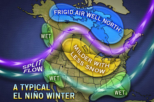
That's why these maps show this scenario more... Strong El Nino sucks for that reason. Too much Pacific flow. You can even see a Ridge in the Pacific with this but it can mean its flowing right down the rockies and into the Mid West. Polar jet Stream would be too far north for us.
When the Cold has little resistance into the U.S, that's when we get seriously cold. But when it meets resistance of the warmth.. we just don't win. It moderates or retreats north.
"Normal" Northeast is probably best to say at this point but that to me is just ... TOO WARM!
Northern New England actually has a good chance of a Very Cold snowy winter.
Okay, that makes sense. Yeah, a lot of factors. Still plenty of uncertainty, though.
Barring the Dissipation of that Huge Pool of Warm Water in the North Pacific it looks like the weather where I live this coming winter would be the absolute worst of both worlds, not only bitterly cold but very dry as well, I would much rather have significant snowfalls with that bitter cold, thank you very much
We won't be able to get bitter cold unless we have a good snow pack. Let's hope that the North Pacific warm blob steers some Alberta Clippers or Saskatchewan Screamers into the Midwest. The the cold can pour down from Canada
Forget about that blob. There are other more important factors in play this year.
And again... There's a warm blob right now but have you seen what's been happening? Jet stream pushing "DOWN", not up in that area. Ignore the hype of those warm waters out there. It doesn't always mean High Pressure and a ridge in the West.
And Midwest wont get cold if there is Pacific air moving in fast.
We need a true fundamental change for things to look colder for us. Still waiting to see anything and I'll know when it does..
Also..understand, our deepest and long lasting cold outbreaks does not come directly from the North or Northeast. As the Earth spins and atmosphere flows, the best is from the NW.
So think about what happens if
1. Central Canada is too warm. (air wont be frigid coming into the U.S and moderate moving east)
2. There's no dive of the Jet Stream. Its more flat or north more. No cold air will be coming into the U.S except for New England.
So where is that in a typical El Nino year? NOPE.
Lets hope it's not "typical"
Please register to post and access all features of our very popular forum. It is free and quick. Over $68,000 in prizes has already been given out to active posters on our forum. Additional giveaways are planned.
Detailed information about all U.S. cities, counties, and zip codes on our site: City-data.com.

 Please register to participate in our discussions with 2 million other members - it's free and quick! Some forums can only be seen by registered members. After you create your account, you'll be able to customize options and access all our 15,000 new posts/day with fewer ads.


")