Please register to participate in our discussions with 2 million other members - it's free and quick! Some forums can only be seen by registered members. After you create your account, you'll be able to customize options and access all our 15,000 new posts/day with fewer ads.
It was snowing lightly yesterday morning here as well. The snow that fell Tuesday is still on the grounded in shaded areas. That's pretty good for us because it was only 2 inches/5 cm. It's 14 F (-10 C) right now, and only supposed to reach 21 F (-6 C) as a high temperature today, so I think the snow that's left will stay with us yet another day.
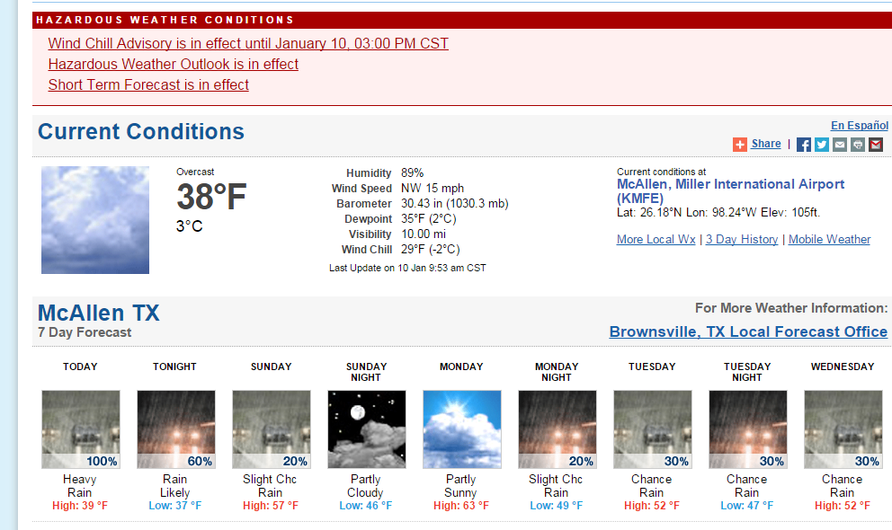
..WIND CHILL ADVISORY REMAINS IN EFFECT UNTIL 3 PM CST THIS
AFTERNOON...
* WIND CHILL VALUES...TO REMAIN BETWEEN 23 AND 30 DEGREES.
* TIMING...THROUGH 3 PM.
* IMPACT...DANGEROUSLY COLD WIND CHILL VALUES MAY LEAD TO
HYPOTHERMIA OR FROSTBITE DURING EXTENDED PERIODS ON EXPOSED
SKIN. DRESS IN LAYERS BEFORE VENTURING OUTSIDE. CHILDREN AND
ADULTS STANDING OUTSIDE FOR LONG DURATION...SUCH AS AT BUS
STOPS SHOULD TAKE EXTRA PRECAUTIONS TO STAY WARM. PETS AND
LIVESTOCK MAY BECOME STRESSED DUE TO THE COLD TEMPERATURES.
MAKE SURE ADEQUATE SHELTER IS AVAILABLE.
After windchills down to 12 F/-11 C, New Orleans is expected to bounce back to near 70 F/21 C with thunderstorms possible midweek. Classic wild swings of the south.
looks like the storm will culminate around midnight.
really strong gusts here now. trees bowing considerably.
Please register to post and access all features of our very popular forum. It is free and quick. Over $68,000 in prizes has already been given out to active posters on our forum. Additional giveaways are planned.
Detailed information about all U.S. cities, counties, and zip codes on our site: City-data.com.

 Please register to participate in our discussions with 2 million other members - it's free and quick! Some forums can only be seen by registered members. After you create your account, you'll be able to customize options and access all our 15,000 new posts/day with fewer ads.


 .
.