Please register to participate in our discussions with 2 million other members - it's free and quick! Some forums can only be seen by registered members. After you create your account, you'll be able to customize options and access all our 15,000 new posts/day with fewer ads.
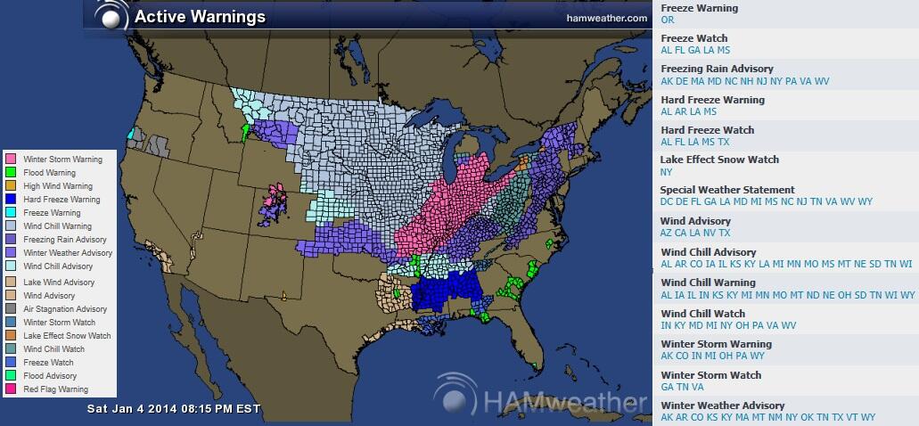
Current Watches & Warnings Map. 18 states have a Wind Chill Warning in them. 11 have an Ice advisory. 7 with a Winter Storm Warning. In fact, the Lower 48 has 38 states with a Winter alert in them. Only 10 do not.
It was -9 F/-23 C here this morning. I was outside at work for approximately half an hour during this morning's low and it was brutal. My feet were killing me. I kept jumping in my car to warm up for a few seconds, then would jump back outside to do some work.
The high yesterday was only 13 F/-11 C. The day before the snowstorm felt notably cold. It was around 20 F/-7 C, but with high humidity and wind.
Freezing rain advisory for tomorrow morning. Temperature will shoot up to around 40 F/4 C Monday before plummeting back below 0 F/-18 C. Tuesday is forecast to only reach 10 F/-12 C.
Last edited by ilovemycomputer90; 01-04-2014 at 07:26 PM..
With the churning of the big storm that is gathering strength in the mid-west and poised to become one to go down in the record books, I came across this photo from where I used to live in NE Indiana. It may have been 36 yrs ago, but I can still recall much of those days that blizzard kept going and going. Sorry for the trip down memory lane.
Concerned for more ice than expected now. Amazing what a snowpack does.
Here's the current temps (numbers) & 850mb temps (shaded background). If you're below that line and your surface temp is below freezing that means Freezing Rain or sleet will fall. Take a look at some areas still in single digits and teens!
It's 11°F here meanwhile the temp above my head at 4000 feet is above freezing. NOT GOOD
NAM6z sounding for NYC at 1pm today. Look at the inversion! Warm air surging in the mid levels of the atmosphere and warming up all the way down to about 500 feet but the surface staying below freezing.
So the moisture falling from the sky is liquid but refreezing at the surface on contact.
So because of this storm tracking like this warm air is surging north. Blue line is the freezing line at 4000'. But whats happening is the surface is staying below freezing!
So take a look at the latest update with Current Temps with metars & surface pressure boxed.
It's Impressive that the surface is still in single digits & teens in spots and moisture is working its way in already. And its above freezing up above our heads
Philly and NYC have freezing rain. It's 2F degrees in Danbury, CT
Please register to post and access all features of our very popular forum. It is free and quick. Over $68,000 in prizes has already been given out to active posters on our forum. Additional giveaways are planned.
Detailed information about all U.S. cities, counties, and zip codes on our site: City-data.com.

 Please register to participate in our discussions with 2 million other members - it's free and quick! Some forums can only be seen by registered members. After you create your account, you'll be able to customize options and access all our 15,000 new posts/day with fewer ads.


 More than some points north like here.
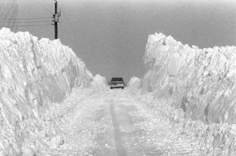


 And its above freezing up above our heads

