Please register to participate in our discussions with 2 million other members - it's free and quick! Some forums can only be seen by registered members. After you create your account, you'll be able to customize options and access all our 15,000 new posts/day with fewer ads.
At least my forecast doesn't noteworthily cold, just a bit below average.
.
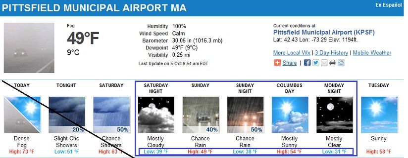
Well, not sure your exact location or if you're using weatherunderground again, but using Pittsfield in Western MA , Normal High is 59. Normal low is 48.
This doesnt look "a bit" below. lol In fact, the high Sunday will be what the Normal low should be.
The entire region will be 6-12 degrees below normal for highs and lows.
Its possible all week after a 1 day warmup to normal on Tuesday.
At least my forecast doesn't noteworthily cold, just a bit below average.
This morning: fog so thick it's hard to see the neighbor's house.
I think you'll see some cooler weather come through this weekend, and Monday will be the coolest day, but the return flow should set up nicely by the middle of next week, so temps even where you are should be normal.
I see no below normal cool weather for the next 10 days after that (this coming Monday) in much of the USA.
Well, not sure your exact location or if you're using weatherunderground again, but using Pittsfield in Western MA , Normal High is 59. Normal low is 48.
This doesnt look "a bit" below. lol In fact, the high Sunday will be what the Normal low should be.
The entire region will be 6-12 degrees below normal for highs and lows.
Its possible all week after a 1 day warmup to normal on Tuesday.
That's a higher elevation weather station than me. I live in the Conneticut River valley at about 200 feet. Lowest high forecast is 57°F for Sunday, and that day is cloudy. The following days have a high around or slightly above 60. Definitely below average, but nothing out of range. Actually today's high of 80°F is more off, but it's one day. My average for today is 66/42.
It's cooled down to 9°C (48°F) here, still warmer than normal but not ridiculously so. Looking forward to 4°C (39°F) nights now, above average as well but no longer warm.
They might get a few fleeting flakes in the high country of New York, mts of New England (above 1500 ft), and maybe PA (above 2000 ft) on Sunday, then the flow goes back to WSW next week. NYC and Philly should have a shot at at least 75 F by the middle of next week under sunny skies I would think.
Lol, highest temperature I see next week for NYC is 66 F, sorry man, I know how badly you want some last breaths of warm/hot weather this fall, looks like you're not gonna get it , sorry pal.
That's a higher elevation weather station than me. I live in the Conneticut River valley at about 200 feet. Lowest high forecast is 57°F for Sunday, and that day is cloudy. The following days have a high around or slightly above 60. Definitely below average, but nothing out of range. Actually today's high of 80°F is more off, but it's one day. My average for today is 66/42.
1200 feet and 200 feet isnt like a 3000 foot difference..
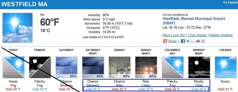
Here's a forecast for 271 feet. A bit warmer BUT REMEMBER... that means your normals are warmer too! Your Normal High is mid 60s.Your Normal low is mid 40s.
Still shows 5-10 degrees below normal. Not sure what your "out of range" definition is. Mine is anything over 5 above/below normal.
This isnt a local thing, this cold front is widespread over the entire region. And because you dont have direct ocean influence expect it to get colder than normal by 10 degrees Sunday and Monday night.
1200 feet and 200 feet isnt like a 3000 foot difference..
Here's a forecast for 271 feet. A bit warmer BUT REMEMBER... that means your normals are warmer too! Your Normal High is mid 60s.Your Normal low is mid 40s.
Still shows 5-10 degrees below normal. Not sure what your "out of range" definition is. Mine is anything over 5 above/below normal.
Mine would be closer to 10°F above/below. We have a variable climate. Anyhow, the standard deviaion in maximum is 7.7°F, minimum 9.0°F. My normal low is 42°F not really mid 40s.
This isnt a local thing, this cold front is widespread over the entire region. And because you dont have direct ocean influence expect it to get colder than normal by 10 degrees Sunday and Monday night.
I still think this is just typical October weather. Our forecast shows a rather cool Sunday, but by middle of next week right back very close to normal. Our avg high next Thursday, October 11th is 68/50f. Our forecast shows we are right about average by the middle of next week.
Please register to post and access all features of our very popular forum. It is free and quick. Over $68,000 in prizes has already been given out to active posters on our forum. Additional giveaways are planned.
Detailed information about all U.S. cities, counties, and zip codes on our site: City-data.com.

 Please register to participate in our discussions with 2 million other members - it's free and quick! Some forums can only be seen by registered members. After you create your account, you'll be able to customize options and access all our 15,000 new posts/day with fewer ads.


 , sorry pal.