Long ago on independence square (Liberty, Jackson: apartments, house, living)
Please register to participate in our discussions with 2 million other members - it's free and quick! Some forums can only be seen by registered members. After you create your account, you'll be able to customize options and access all our 15,000 new posts/day with fewer ads.
For review here are a couple of shots from 1957 along that RR route. The tracks were removed about 1933, but parts of its path are still visible in these views.
There is a video out there somewhere made by the late RR enthusiast Ernie Griffin. It is taken from the engine of a train traveling from Pixley to the mainline on the Pixley spur. I have viewed it on VHS borrowed from another RR nut, and it is a view of town that few get to see. I don't find it on YouTube. He also had video from a Gateway Western train traveling from Rock Creek Junction to eastern Missouri on the old C&A line. That one shows the old C&A Depot not long before it was moved.
In the bottom photo, it appears to be show the tracks crossing back over Truman just west of Alexander Rd and angling southeast to cross over Holke and further yet to disappear just north of Mo. 78. On Jackson County maps, I've noticed an Adams Station on the east side of Holke along side of the tracks. I haven't been able to determine thus far, just when Holke continued north, (which became Jones Rd, and now S. Jones Rd) In 1931, Holke/Jones did not exist. But in 1946, it did. Someday I'll pin down the year it cut through, AND, when they closed Adams Station.
In the bottom photo, it appears to be show the tracks crossing back over Truman just west of Alexander Rd and angling southeast to cross over Holke and further yet to disappear just north of Mo. 78. On Jackson County maps, I've noticed an Adams Station on the east side of Holke along side of the tracks. I haven't been able to determine thus far, just when Holke continued north, (which became Jones Rd, and now S. Jones Rd) In 1931, Holke/Jones did not exist. But in 1946, it did. Someday I'll pin down the year it cut through, AND, when they closed Adams Station.
Welcome back Doc! The tracks did indeed cross there. Here is an 1877 map showing the route.
I first remember hearing of the Lewis and Clark Expedition in Miss Barton’s fourth grade class at McCoy School at 1010 S Pearl. I doubt if she gave out all this information but here are some important dates leading up to and away from the military expedition, plus two questions.
January 1803: President Jefferson asks Congress for a secret appropriation of $2,500 to send a covert military expedition into the vast area west of the Mississippi River.
April 1803: The Louisiana Purchase is negotiated with France.
December 1803: Congress approved the treaty with France and appropriated $15m to pay for 828,000 acres of land.
March 1804: The Louisiana Purchase is divided into Orleans Territory taking up the southernmost part of the purchase and the remainder becomes the District of Louisiana.
May 1804: Lewis and Clark take off from Saint Louis in the District of Louisiana to explore the new land.
June 1804: Lewis and Clark camp on a Missouri River site about 14 crow miles from the future Independence Square that they recommend in their journal for building a frontier fort at a later date.
July 1805: The District of Louisiana becomes Louisiana Territory
August 1805: When Lewis and Clark get to what is now western Montana at the end of what they knew as the District of Louisiana (renamed to Louisiana Territory while they were gone) they kept going. They left the territorial limits of the United States entering into another country in accordance with their orders. This was a US armed military expedition disguised as a “Corps of Discovery” invading another country’s sovereign territory. Another disguise is that the Corps of Discovery has a woman on board to not only serve as guide--at least part of the way—but also to give the outward impression that they are a nonviolent force. The force consists of around fifty members including contractors and one slave.
September 1806: Lewis and Clark return to Saint Louis a relatively short time after Meriwether Lewis is wounded by gunfire.
Fall 1808: Fort Osage near present day Sibley is constructed
April 1812: Orleans Territory becomes the state of Louisiana.
June 1812: Louisiana Territory becomes Missouri Territory
March 1819: The southernmost part of Missouri Territory becomes Arkansaw Territory—later changed to Arkansas Territory.
August 1821: Most of present day Missouri becomes a state.
Questions:
What foreign country did the Lewis and Clark Expedition invade?
What foreign country invaded US territory by sending two military expeditions to attack the 50-man Lewis and Clark expedition? The first force consisted of 200 men. The second force consisted of 600 men.
How did this foreign country learn of the approximate route of the Lewis and Clark Expedition?
The Louisiana Territory belonged to Spain until the French took it over in 1800. France had owned the area previous to Spanish ownership.
Over Spanish objections, the French sold it to the U.S. in 1803.
Questions:
What foreign country did the Lewis and Clark Expedition invade?
Great Britain.
The land from western Montana to the Pacific Ocean was part of British America and did not belong to the United States until 1846, although there was an agreement made for joint citizen occupancy in 1818, twelve years after the Lewis and Clark Expedition came to an end.
What foreign country invaded US territory by sending two military expeditions to attack the 50-man Lewis and Clark expedition? The first force consisted of 200 men. The second force consisted of 600 men.
Spain.
At one time, the Spanish came within ten days of the Lewis and Clark Expedition but their paths never crossed. The Shoshone warned the expedition of the Spanish being close by but the expedition, even though they did not want to make contact, had no clue the Spanish were after them. Some information states that Spain actually sent three forces and some say four different forces after Lewis and Clark. In August 1806 Meriwether Lewis was accidentally shot in the butt by one of his own men while hunting. Lewis had to lay on his stomach during the canoe ride home down the Missouri.
How did this foreign country learn of the approximate route of the Lewis and Clark Expedition?
General James Wilkinson governor of Louisiana Territory was a spy for Spain—serving in this role by traveling to the then Spanish ruled New Orleans to sign up as a paid informant. He sent a coded message to the Spanish advising of their route up the Missouri River and suggested they intercept Lewis and Clark. He is also known as the man who double crossed the founders. Wilkinson was replaced by Meriwether Lewis in 1807 and there was some thought he had something to do with the suicide or murder of Meriwether Lewis in 1809. Agent 13 as he was known to Spain was not outed until several years after he died in 1825 in Mexico City.
In a followup to the Lewis and Clark Expedition expedition in 1807, that explored the southern part of the Louisiana Territory north of the Orleans Territory, the Spanish did capture the US Army members of this expedition led by Zebulon Pike. They were held captive in Santa Fe for several months before being escorted out of Spanish Territory and released back to the U.S. The expedition had built a fort inside Spanish Territory just as Lewis and Clark had built Fort Clatsop in British Territory.
Welcome back Doc! The tracks did indeed cross there. Here is an 1877 map showing the route.
Thanks, Mad! I can see on your map that Peter Adams owned the property where I now live, and more than likely was who Adams Station was named after. I'm curious though, as to whether Adams Station was an actual train depot, or a small whistle stop. Also, I see the names C Poteet, and G.L. Compton. There is a cemetery on top of what we called Rattlesnake Hill when I was a kid, (which is now part of the Remington housing addition at Holke and Mo. 78) that's called Poteet/Compton. I've always wondered where the name came from, now i know! There's a Ewing Chrisman who was more than likely related to John Chrisman and his wife Marie that had owned the land after Peter Adams, and had sold part of their property which is now the "Chrisman Addition" (plated in 1953), in which I live on lot 8. Also, There's a George Fisher that owned a large farm, just north of where I live (S. Jones Rd) that was built around the time this map was made, and is still there. There was a write up in one of the Jackson County Historical Society Journals, along with photos. It had been built initially as a log cabin and added to over the years. It's very interesting reading. I met a gal on a Indep. Facebook page that is related to the Fishers AND the Chrismans. Other members of her family, (Jacob Powell and Peter Adams) donated the land that Spring Branch Elementary was built on in 1879. Sorry I rambled on, but when I talk about my neighborhood, I go off on a tangent! Thanks again for the map!
Thanks, Mad! I can see on your map that Peter Adams owned the property where I now live, and more than likely was who Adams Station was named after. I'm curious though, as to whether Adams Station was an actual train depot, or a small whistle stop. Also, I see the names C Poteet, and G.L. Compton. There is a cemetery on top of what we called Rattlesnake Hill when I was a kid, (which is now part of the Remington housing addition at Holke and Mo. 78) that's called Poteet/Compton. I've always wondered where the name came from, now i know! There's a Ewing Chrisman who was more than likely related to John Chrisman and his wife Marie that had owned the land after Peter Adams, and had sold part of their property which is now the "Chrisman Addition" (plated in 1953), in which I live on lot 8. Also, There's a George Fisher that owned a large farm, just north of where I live (S. Jones Rd) that was built around the time this map was made, and is still there. There was a write up in one of the Jackson County Historical Society Journals, along with photos. It had been built initially as a log cabin and added to over the years. It's very interesting reading. I met a gal on a Indep. Facebook page that is related to the Fishers AND the Chrismans. Other members of her family, (Jacob Powell and Peter Adams) donated the land that Spring Branch Elementary was built on in 1879. Sorry I rambled on, but when I talk about my neighborhood, I go off on a tangent! Thanks again for the map!
Tangents are welcome here! Perhaps this will encourage another one- here is the same area as allotted in 1911...
There seems to be some discrepancy between the two maps as to the exact crossing point of the RR and Truman Road, and the alignment of Truman itself.
Today's quiz is a bit different, because I'll ask a question for which I don't have the answer! However, I'm sure that with our collective brain power we can get close to the truth.
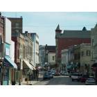
I recently ran across this photo of Uptown Independence, but it is not dated. Together I think we can come up with a fairly narrow time frame that it was taken in.
Please peruse and pick out details that can narrow down the date.
Today's quiz is a bit different, because I'll ask a question for which I don't have the answer! However, I'm sure that with our collective brain power we can get close to the truth.
I recently ran across this photo of Uptown Independence, but it is not dated. Together I think we can come up with a fairly narrow time frame that it was taken in.
Please peruse and pick out details that can narrow down the date.
For starters:
This has got to be around 1954 due, for one thing, to the color in the cars.
The Hudson dealership and a flooring store on South Liberty across from the old A&P is a parking lot. That place burned in ’49, I believe.
Chrisman Sawyer Bank has not yet been remodeled and still has a hip roof. Remodeling came, maybe, in '56 or so.
Main Street by the square appears to be one-way so it is after the streets went one-way.
Truman appears to be two-lane. Widening was around '55, or so.
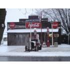
Mad, in your days at Bryant was there a grocery store at this location to the left?
I just read an article on the Examiner online that mentions this place as being a grocery store until 1943 at least.
Come now, I'm not quite that old! In my days it wasn't a grocery, but I don't recall what it was. Just east of it, which is now part of a parking lot, was another storefront that was sometimes a small church. In my 1988 Polks it was a church, with the corner store listed as Thompson's Florist.
I'll check older directories the next time I'm at the library.
Please register to post and access all features of our very popular forum. It is free and quick. Over $68,000 in prizes has already been given out to active posters on our forum. Additional giveaways are planned.
Detailed information about all U.S. cities, counties, and zip codes on our site: City-data.com.

 Please register to participate in our discussions with 2 million other members - it's free and quick! Some forums can only be seen by registered members. After you create your account, you'll be able to customize options and access all our 15,000 new posts/day with fewer ads.