Bridge Statistics for New Orleans, Louisiana (LA)
Condition, Traffic, Stress, Structural Evaluation, Project Costs
- National Bridge Inventory (NBI) Statistics
- 840Number of bridges
- 69,872ft / 21,297mTotal length
- $922,208,000Total costs
- 18,135,528Total average daily traffic
- 2,072,962Total average daily truck traffic
- National Bridge Inventory (NBI) Registered Bridges for New Orleans
- No street view available for this location
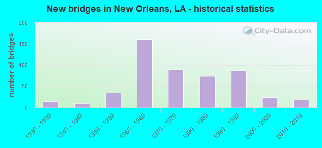
- New bridges - historical statistics
- 11910-1919
- 11920-1929
- 151930-1939
- 101940-1949
- 351950-1959
- 1601960-1969
- 901970-1979
- 741980-1989
- 871990-1999
- 242000-2009
- 192010-2019
- 12020-2022
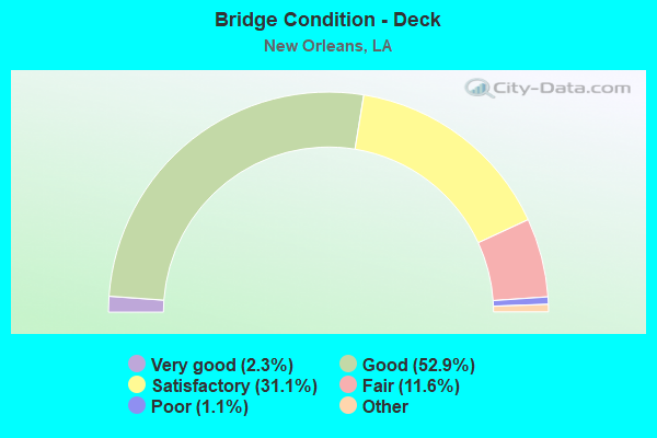
- Bridge Condition - Deck
- 2.3%Very good
- 52.9%Good
- 31.1%Satisfactory
- 11.6%Fair
- 1.1%Poor
- 1.1%Serious
- 0.8%Failed
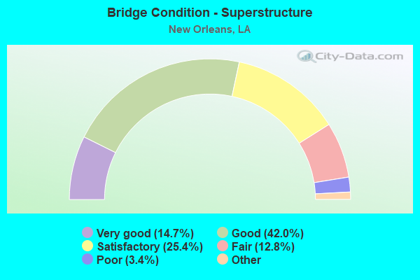
- Bridge Condition - Superstructure
- 14.7%Very good
- 42.0%Good
- 25.4%Satisfactory
- 12.8%Fair
- 3.4%Poor
- 1.7%Serious
- 0.2%Imminent failure
- 0.8%Failed
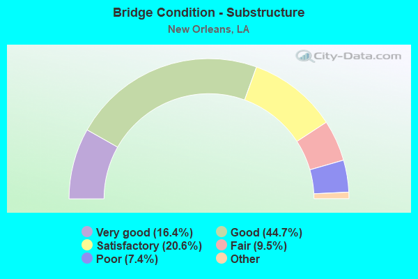
- Bridge Condition - Substructure
- 16.4%Very good
- 44.7%Good
- 20.6%Satisfactory
- 9.5%Fair
- 7.4%Poor
- 1.5%Serious
- 0.2%Imminent failure
- 0.8%Failed
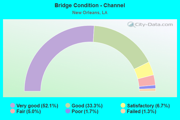
- Bridge Condition - Channel
- 52.1%Very good
- 33.3%Good
- 6.7%Satisfactory
- 5.0%Fair
- 1.7%Poor
- 1.3%Failed
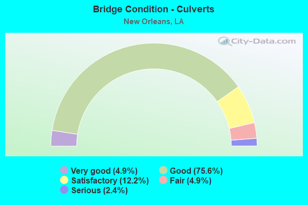
- Bridge Condition - Culverts
- 4.9%Very good
- 75.6%Good
- 12.2%Satisfactory
- 4.9%Fair
- 2.4%Serious
Find on map >> Show street view
Structure Number: 23604509008512, Location: 2.5 MI EAST OF LA 39 (Lat: 30.003719, Lng: -90.031400), Route carried "on" structure: Interstate 10, Year Built: 1966, Status: Open, Structure Length: 59.74m (196.00ft), Average Daily Traffic: 58,250 (year 2016), Truck Traffic: 25%, Average Future Daily Traffic: 120,972 (year 2036), Design Load: HS 20, Features Intersected: CITY STREETS
Minimum Vertical Clearance: 30+ m (98+ ft), Kilometerpoint: 25.037, Lanes on structure: 3, Lanes under structure: 20, Base Highway Network: Yes (Inventory Route: 450-90-2, Subroute: 10), Owner: State Highway Agency, Approaching Roadway Width: 14.6m (47.9ft), Skew: 30 degrees, Material/Design: Steel, Design/Construction: Stringer/Multi-beam, Number Of Spans In Main Unit: 1, Number Of Approach Spans: 33, Length of Maximum Span: 39.6m (129.9ft), Curb-To-Curb Width: 13.7m (44.9ft), Out-to-Out Width: 14.6m (47.9ft)
Condition: Deck: Satisfactory, Superstructure: Good, Substructure: Good, Operating Rating: 80.7 metric tons, Method Used To Determine Operating Rating: Load Factor (LF), Inventory Rating: 48.1 metric tons, Method Used To Determine Inventory Rating: Load Factor (LF), Structural Evaluation: Better than present minimum criteria, Deck Geometry: Meets minimum limits, Approach Roadway Alignment: Equal to present desirable criteria, Designated Inspection Frequency: Every 24 months, Inspection Date: August 2021, Deck Structure Type: Concrete Cast-file-Place, Wearing Surface/Protective System: Wearing Surface: Monolithic Concrete
Find on map >> Show street view
Structure Number: 23604509008677, Location: 2.6 MI EAST OF LA 39 (Lat: 30.002339, Lng: -90.034800), Route carried "on" structure: Ramp Interstate 10, Year Built: 1992, Status: Open, Structure Length: 15.30m (50.20ft), Average Daily Traffic: 11,650 (year 2016), Truck Traffic: 25%, Average Future Daily Traffic: 20,162 (year 2036), Design Load: HS 20, Features Intersected: CITY STREETS/RR
Minimum Vertical Clearance: 30+ m (98+ ft), Kilometerpoint: 0.055, Lanes on structure: 1, Lanes under structure: 4, Owner: State Highway Agency, Approaching Roadway Width: 8.5m (27.9ft), Material/Design: Prestressed concrete, Design/Construction: Stringer/Multi-beam, Number Of Spans In Main Unit: 6, Number Of Approach Spans: 6, Length of Maximum Span: 19.8m (65.0ft), Curb-To-Curb Width: 8.5m (27.9ft), Out-to-Out Width: 9.4m (30.8ft)
Condition: Deck: Good, Superstructure: Good, Substructure: Satisfactory, Operating Rating: 66.2 metric tons, Method Used To Determine Operating Rating: Load Factor (LF), Inventory Rating: 39.9 metric tons, Method Used To Determine Inventory Rating: Load Factor (LF), Structural Evaluation: Equal to present minimum criteria, Deck Geometry: Superior to present desirable criteria, Underclear: Meets minimum limits, Approach Roadway Alignment: Equal to present desirable criteria, Designated Inspection Frequency: Every 24 months, Inspection Date: January 2020, Deck Structure Type: Concrete Cast-file-Place
Find on map >> Show street view
Structure Number: 23604509008805, Location: 2.8 MI EAST OF LA 39 (Lat: 30.002811, Lng: -90.034800), Route carried "on" structure: Ramp Interstate 10, Year Built: 1966, Status: Open, Structure Length: 17.98m (58.99ft), Average Daily Traffic: 11,650 (year 2016), Truck Traffic: 25%, Average Future Daily Traffic: 20,162 (year 2036), Design Load: HS 20, Features Intersected: ON RAMP I-10E.
Minimum Vertical Clearance: 30+ m (98+ ft), Kilometerpoint: 0.053, Lanes on structure: 1, Owner: State Highway Agency, Approaching Roadway Width: 6.1m (20.0ft), Material/Design: Prestressed concrete, Design/Construction: Stringer/Multi-beam, Number Of Spans In Main Unit: 9, Number Of Approach Spans: 7, Length of Maximum Span: 15.2m (49.9ft), Curb-To-Curb Width: 5.5m (18.0ft), Out-to-Out Width: 7.2m (23.6ft)
Condition: Deck: Good, Superstructure: Good, Substructure: Good, Operating Rating: 59.0 metric tons, Method Used To Determine Operating Rating: Load Factor (LF), Inventory Rating: 35.4 metric tons, Method Used To Determine Inventory Rating: Load Factor (LF), Structural Evaluation: Better than present minimum criteria, Deck Geometry: Meets minimum limits, Approach Roadway Alignment: Better than present minimum criteria, Designated Inspection Frequency: Every 24 months, Inspection Date: December 2021, Deck Structure Type: Concrete Cast-file-Place
Find on map >> Show street view
Structure Number: 23604509008808, Location: 2.8 MI EAST OF LA 39 (Lat: 30.003550, Lng: -90.032800), Route carried "on" structure: Ramp Interstate 10, Year Built: 1966, Status: Open, Structure Length: 16.92m (55.51ft), Average Daily Traffic: 11,650 (year 2016), Truck Traffic: 25%, Average Future Daily Traffic: 18,343 (year 2036), Design Load: HS 20, Features Intersected: OFF RAMP I-10W.
Minimum Vertical Clearance: 30+ m (98+ ft), Kilometerpoint: 0.082, Lanes on structure: 1, Lanes under structure: 1, Owner: State Highway Agency, Approaching Roadway Width: 12.2m (40.0ft), Material/Design: Prestressed concrete, Design/Construction: Stringer/Multi-beam, Number Of Spans In Main Unit: 8, Number Of Approach Spans: 8, Length of Maximum Span: 22.9m (75.1ft), Curb-To-Curb Width: 5.8m (19.0ft), Out-to-Out Width: 7.5m (24.6ft)
Condition: Deck: Good, Superstructure: Satisfactory, Substructure: Good, Operating Rating: 69.8 metric tons, Method Used To Determine Operating Rating: Load Factor (LF), Inventory Rating: 39.9 metric tons, Method Used To Determine Inventory Rating: Load Factor (LF), Structural Evaluation: Equal to present minimum criteria, Deck Geometry: Meets minimum limits, Approach Roadway Alignment: Better than present minimum criteria, Designated Inspection Frequency: Every 24 months, Inspection Date: January 2020, Deck Structure Type: Concrete Cast-file-Place
Find on map >> Show street view
Structure Number: 23604509009447, Location: 3.4 MI EAST OF LA 39 (Lat: 30.005500, Lng: -90.022400), Route carried "on" structure: Ramp Interstate 10, Year Built: 1966, Status: Open, Structure Length: 52.12m (171.00ft), Average Daily Traffic: 11,650 (year 2016), Truck Traffic: 25%, Average Future Daily Traffic: 18,343 (year 2036), Design Load: HS 20, Features Intersected: I-10 EAST & WEST US90
Minimum Vertical Clearance: 5.18m (16.99ft), Kilometerpoint: 0.172, Lanes on structure: 2, Lanes under structure: 6, Owner: State Highway Agency, Approaching Roadway Width: 14.0m (45.9ft), Material/Design: Steel, Design/Construction: Stringer/Multi-beam, Number Of Spans In Main Unit: 4, Number Of Approach Spans: 31, Length of Maximum Span: 45.7m (149.9ft), Curb-To-Curb Width: 6.9m (22.6ft), Out-to-Out Width: 8.5m (27.9ft)
Condition: Deck: Satisfactory, Superstructure: Good, Substructure: Good, Operating Rating: 60.8 metric tons, Method Used To Determine Operating Rating: Load Factor (LF), Inventory Rating: 36.3 metric tons, Method Used To Determine Inventory Rating: Load Factor (LF), Structural Evaluation: Better than present minimum criteria, Deck Geometry: High priority of replacement, Underclear: High priority of replacement, Approach Roadway Alignment: Equal to present desirable criteria, Length Of Structure Improvement: 52.12m (171.00ft), Designated Inspection Frequency: Every 24 months, Inspection Date: September 2021, Bridge Improvement Cost: $4,446,000, Total Project Cost: $6,669,000 ( Estimate for 2016), Deck Structure Type: Concrete Cast-file-Place
Find on map >> Show street view
Structure Number: 23604509009532, Location: 02364509009532 (Lat: 30.007061, Lng: -90.016900), Route carried "on" structure: Interstate 10, Year Built: 1966, Status: Open, Structure Length: 42.37m (139.01ft), Average Daily Traffic: 58,250 (year 2016), Truck Traffic: 25%, Average Future Daily Traffic: 110,058 (year 2036), Design Load: HS 20, Features Intersected: GROUND
Minimum Vertical Clearance: 30+ m (98+ ft), Kilometerpoint: 23.588, Lanes on structure: 3, Lanes under structure: 2, Base Highway Network: Yes (Inventory Route: 450-90-2, Subroute: 10), Owner: State Highway Agency, Approaching Roadway Width: 14.3m (46.9ft), Skew: 30 degrees, Material/Design: Steel, Design/Construction: Stringer/Multi-beam, Number Of Spans In Main Unit: 5, Number Of Approach Spans: 23, Length of Maximum Span: 33.5m (109.9ft), Curb-To-Curb Width: 13.7m (44.9ft), Out-to-Out Width: 29.3m (96.1ft)
Condition: Deck: Good, Superstructure: Good, Substructure: Satisfactory, Operating Rating: 80.7 metric tons, Method Used To Determine Operating Rating: Load Factor (LF), Inventory Rating: 48.1 metric tons, Method Used To Determine Inventory Rating: Load Factor (LF), Structural Evaluation: Equal to present minimum criteria, Deck Geometry: Meets minimum limits, Approach Roadway Alignment: Better than present minimum criteria, Designated Inspection Frequency: Every 24 months, Inspection Date: September 2021, Deck Structure Type: Concrete Cast-file-Place, Wearing Surface/Protective System: Wearing Surface: Monolithic Concrete
Find on map >> Show street view
Structure Number: 23604509009606, Location: 3.6 MI EAST OF LA 39 (Lat: 30.008989, Lng: -90.020800), Route carried "on" structure: Ramp Interstate 10, Year Built: 1966, Status: Open, Structure Length: 32.31m (106.00ft), Average Daily Traffic: 11,650 (year 2016), Truck Traffic: 25%, Average Future Daily Traffic: 18,343 (year 2036), Design Load: HS 20, Features Intersected: OLD GENTILLY RD
Minimum Vertical Clearance: 30+ m (98+ ft), Kilometerpoint: 0.113, Lanes on structure: 1, Lanes under structure: 2, Owner: State Highway Agency, Approaching Roadway Width: 6.1m (20.0ft), Material/Design: Prestressed concrete, Design/Construction: Stringer/Multi-beam, Number Of Spans In Main Unit: 20, Number Of Approach Spans: 6, Length of Maximum Span: 18.3m (60.0ft), Curb-To-Curb Width: 5.5m (18.0ft), Out-to-Out Width: 7.5m (24.6ft)
Condition: Deck: Good, Superstructure: Good, Substructure: Good, Operating Rating: 65.3 metric tons, Method Used To Determine Operating Rating: Load Factor (LF), Inventory Rating: 39.0 metric tons, Method Used To Determine Inventory Rating: Load Factor (LF), Structural Evaluation: Better than present minimum criteria, Deck Geometry: Meets minimum limits, Underclear: Better than present minimum criteria, Approach Roadway Alignment: Equal to present desirable criteria, Designated Inspection Frequency: Every 24 months, Inspection Date: September 2021, Deck Structure Type: Concrete Cast-file-Place
Find on map >> Show street view
Structure Number: 23604509009981, Location: 3.9 MI EAST OF LA 39 (Lat: 30.008261, Lng: -90.015531), Route carried "on" structure: Interstate 10, Year Built: 1967, Status: Open, Structure Length: 37.31m (122.41ft), Average Daily Traffic: 120,200 (year 2016), Truck Traffic: 25%, Average Future Daily Traffic: 181,560 (year 2036), Design Load: HS 20, Features Intersected: I-10
Minimum Vertical Clearance: 30+ m (98+ ft), Kilometerpoint: 16.164, Lanes on structure: 2, Lanes under structure: 7, Base Highway Network: Yes (Inventory Route: 450-90-1, Subroute: 10), Owner: State Highway Agency, Approaching Roadway Width: 9.8m (32.2ft), Material/Design: Steel continuous, Design/Construction: Stringer/Multi-beam, Number Of Spans In Main Unit: 4, Number Of Approach Spans: 19, Length of Maximum Span: 36.6m (120.1ft), Curb-To-Curb Width: 8.5m (27.9ft), Out-to-Out Width: 10.7m (35.1ft)
Condition: Deck: Fair, Superstructure: Satisfactory, Substructure: Good, Operating Rating: 61.7 metric tons, Method Used To Determine Operating Rating: Load Factor (LF), Inventory Rating: 36.3 metric tons, Method Used To Determine Inventory Rating: Load Factor (LF), Structural Evaluation: Equal to present minimum criteria, Deck Geometry: Meets minimum limits, Underclear: High priority of replacement, Approach Roadway Alignment: Equal to present desirable criteria, Length Of Structure Improvement: 37.31m (122.41ft), Designated Inspection Frequency: Every 24 months, Inspection Date: November 2021, Bridge Improvement Cost: $3,182,000, Total Project Cost: $4,773,000 ( Estimate for 2016), Deck Structure Type: Concrete Cast-file-Place
Find on map >> Show street view
Structure Number: 23604509010031, Location: I-10 OVER US 90 (Lat: 30.009061, Lng: -90.013500), Route carried "on" structure: Interstate 10, Year Built: 1967, Status: Open, Structure Length: 38.77m (127.20ft), Average Daily Traffic: 60,100 (year 2016), Truck Traffic: 25%, Average Future Daily Traffic: 108,936 (year 2036), Design Load: HS 20, Features Intersected: I-10 OVER US 90(CHEF HWY
Minimum Vertical Clearance: 30+ m (98+ ft), Kilometerpoint: 16.164, Lanes on structure: 3, Lanes under structure: 6, Base Highway Network: Yes (Inventory Route: 450-90-1, Subroute: 10), Owner: State Highway Agency, Approaching Roadway Width: 17.7m (58.1ft), Skew: 10 degrees, Material/Design: Steel continuous, Design/Construction: Stringer/Multi-beam, Number Of Spans In Main Unit: 2, Number Of Approach Spans: 30, Length of Maximum Span: 21.6m (70.9ft), Curb-To-Curb Width: 12.2m (40.0ft), Out-to-Out Width: 13.4m (44.0ft)
Condition: Deck: Satisfactory, Superstructure: Satisfactory, Substructure: Satisfactory, Operating Rating: 70.7 metric tons, Method Used To Determine Operating Rating: Load Factor (LF), Inventory Rating: 42.6 metric tons, Method Used To Determine Inventory Rating: Load Factor (LF), Structural Evaluation: Equal to present minimum criteria, Deck Geometry: High priority of corrective action, Underclear: Somewhat better than minimum adequacy, Approach Roadway Alignment: Equal to present desirable criteria, Length Of Structure Improvement: 38.77m (127.20ft), Designated Inspection Frequency: Every 24 months, Inspection Date: January 2020, Bridge Improvement Cost: $3,307,000, Total Project Cost: $4,960,000 ( Estimate for 2016), Deck Structure Type: Concrete Cast-file-Place
Find on map >> Show street view
Structure Number: 23604509010042, Location: I-10 OVER US 90 (Lat: 30.012639, Lng: -90.013300), Route carried "on" structure: Interstate 10, Year Built: 1967, Status: Open, Structure Length: 38.62m (126.71ft), Average Daily Traffic: 57,350 (year 2016), Truck Traffic: 25%, Average Future Daily Traffic: 108,936 (year 2036), Design Load: HS 20, Features Intersected: I-10 OVER US 90(CHEF HWY
Minimum Vertical Clearance: 30+ m (98+ ft), Kilometerpoint: 22.800, Lanes on structure: 3, Lanes under structure: 6, Base Highway Network: Yes (Inventory Route: 450-90-2, Subroute: 10), Owner: State Highway Agency, Approaching Roadway Width: 16.5m (54.1ft), Skew: 10 degrees, Material/Design: Steel continuous, Design/Construction: Stringer/Multi-beam, Number Of Spans In Main Unit: 2, Number Of Approach Spans: 27, Length of Maximum Span: 22.9m (75.1ft), Curb-To-Curb Width: 12.2m (40.0ft), Out-to-Out Width: 13.5m (44.3ft)
Condition: Deck: Good, Superstructure: Good, Substructure: Good, Operating Rating: 65.3 metric tons, Method Used To Determine Operating Rating: Load Factor (LF), Inventory Rating: 37.2 metric tons, Method Used To Determine Inventory Rating: Load Factor (LF), Structural Evaluation: Better than present minimum criteria, Deck Geometry: High priority of corrective action, Underclear: Somewhat better than minimum adequacy, Approach Roadway Alignment: Equal to present desirable criteria, Length Of Structure Improvement: 38.62m (126.71ft), Designated Inspection Frequency: Every 24 months, Inspection Date: January 2020, Bridge Improvement Cost: $3,294,000, Total Project Cost: $4,941,000 ( Estimate for 2016), Deck Structure Type: Concrete Cast-file-Place
Find on map >> Show street view
Structure Number: 23604509010135, Location: .1 MI EAST OF US 90 (Lat: 30.009731, Lng: -90.011900), Route carried "on" structure: Ramp Interstate 10, Year Built: 1967, Status: Open, Structure Length: 15.58m (51.12ft), Average Daily Traffic: 12,020 (year 2016), Truck Traffic: 25%, Average Future Daily Traffic: 18,156 (year 2036), Design Load: HS 20, Features Intersected: ON RAMP I-10E.FROM US90
Minimum Vertical Clearance: 30+ m (98+ ft), Kilometerpoint: 0.206, Lanes on structure: 1, Owner: State Highway Agency, Approaching Roadway Width: 6.1m (20.0ft), Material/Design: Prestressed concrete, Design/Construction: Stringer/Multi-beam, Number Of Spans In Main Unit: 5, Number Of Approach Spans: 11, Length of Maximum Span: 18.0m (59.1ft), Curb-To-Curb Width: 5.8m (19.0ft), Out-to-Out Width: 7.5m (24.6ft)
Condition: Deck: Good, Superstructure: Very good, Substructure: Very good, Operating Rating: 70.7 metric tons, Method Used To Determine Operating Rating: Load Factor (LF), Inventory Rating: 49.9 metric tons, Method Used To Determine Inventory Rating: Load Factor (LF), Structural Evaluation: Equal to present desirable criteria, Deck Geometry: Meets minimum limits, Approach Roadway Alignment: Better than present minimum criteria, Designated Inspection Frequency: Every 24 months, Inspection Date: July 2020, Deck Structure Type: Concrete Cast-file-Place
Find on map >> Show street view
Structure Number: 23604509010216, Location: .2 MI EAST OF US 90 (Lat: 30.011850, Lng: -90.014100), Route carried "on" structure: Ramp Interstate 10, Year Built: 1967, Status: Open, Structure Length: 9.51m (31.20ft), Average Daily Traffic: 11,470 (year 2016), Truck Traffic: 25%, Average Future Daily Traffic: 18,156 (year 2036), Design Load: HS 20, Features Intersected: ON RAMP I-10W FROM US90
Minimum Vertical Clearance: 30+ m (98+ ft), Kilometerpoint: 0.209, Lanes on structure: 1, Owner: State Highway Agency, Approaching Roadway Width: 6.1m (20.0ft), Material/Design: Prestressed concrete, Design/Construction: Stringer/Multi-beam, Number Of Spans In Main Unit: 4, Number Of Approach Spans: 4, Length of Maximum Span: 17.7m (58.1ft), Curb-To-Curb Width: 5.8m (19.0ft), Out-to-Out Width: 7.5m (24.6ft)
Condition: Deck: Good, Superstructure: Good, Substructure: Good, Operating Rating: 73.5 metric tons, Method Used To Determine Operating Rating: Load Factor (LF), Inventory Rating: 52.6 metric tons, Method Used To Determine Inventory Rating: Load Factor (LF), Structural Evaluation: Better than present minimum criteria, Deck Geometry: Meets minimum limits, Approach Roadway Alignment: Equal to present minimum criteria, Designated Inspection Frequency: Every 24 months, Inspection Date: May 2021, Deck Structure Type: Concrete Cast-file-Place
Find on map >> Show street view
Structure Number: 23604509010711, Location: .7 MI EAST OF US 90 (Lat: 30.018819, Lng: -90.013600), Route carried "on" structure: Interstate 10, Year Built: 1967, Status: Open, Structure Length: 37.61m (123.39ft), Average Daily Traffic: 57,350 (year 2016), Truck Traffic: 25%, Average Future Daily Traffic: 98,940 (year 2036), Design Load: HS 20, Features Intersected: DWYER CANAL/DWYER RD
Minimum Vertical Clearance: 30+ m (98+ ft), Kilometerpoint: 17.262, Lanes on structure: 3, Lanes under structure: 2, Base Highway Network: Yes (Inventory Route: 450-90-1, Subroute: 10), Owner: State Highway Agency, Approaching Roadway Width: 16.5m (54.1ft), Skew: 10 degrees, Material/Design: Steel continuous, Design/Construction: Stringer/Multi-beam, Number Of Spans In Main Unit: 3, Number Of Approach Spans: 22, Length of Maximum Span: 38.7m (127.0ft), Curb-To-Curb Width: 12.2m (40.0ft), Out-to-Out Width: 13.5m (44.3ft)
Condition: Deck: Satisfactory, Superstructure: Good, Substructure: Good, Operating Rating: 58.0 metric tons, Method Used To Determine Operating Rating: Load Factor (LF), Inventory Rating: 34.5 metric tons, Method Used To Determine Inventory Rating: Load Factor (LF), Structural Evaluation: Better than present minimum criteria, Deck Geometry: High priority of corrective action, Underclear: Meets minimum limits, Approach Roadway Alignment: Equal to present desirable criteria, Length Of Structure Improvement: 37.61m (123.39ft), Designated Inspection Frequency: Every 24 months, Inspection Date: July 2021, Bridge Improvement Cost: $3,208,000, Total Project Cost: $4,812,000 ( Estimate for 2016), Deck Structure Type: Concrete Cast-file-Place
Find on map >> Show street view
Structure Number: 23604509010712, Location: .7 MI EAST OF US 90 (Lat: 30.022139, Lng: -90.014200), Route carried "on" structure: Interstate 10, Year Built: 1967, Status: Open, Structure Length: 37.61m (123.39ft), Average Daily Traffic: 57,350 (year 2016), Truck Traffic: 25%, Average Future Daily Traffic: 98,940 (year 2036), Design Load: HS 20, Features Intersected: DWYER CANAL/DWYER RD
Minimum Vertical Clearance: 30+ m (98+ ft), Kilometerpoint: 21.742, Lanes on structure: 3, Lanes under structure: 2, Base Highway Network: Yes (Inventory Route: 450-90-2, Subroute: 10), Owner: State Highway Agency, Approaching Roadway Width: 16.5m (54.1ft), Skew: 10 degrees, Material/Design: Steel continuous, Design/Construction: Stringer/Multi-beam, Number Of Spans In Main Unit: 3, Number Of Approach Spans: 22, Length of Maximum Span: 38.7m (127.0ft), Curb-To-Curb Width: 12.2m (40.0ft), Out-to-Out Width: 13.5m (44.3ft)
Condition: Deck: Satisfactory, Superstructure: Good, Substructure: Satisfactory, Operating Rating: 71.7 metric tons, Method Used To Determine Operating Rating: Load Factor (LF), Inventory Rating: 43.5 metric tons, Method Used To Determine Inventory Rating: Load Factor (LF), Structural Evaluation: Equal to present minimum criteria, Deck Geometry: High priority of corrective action, Underclear: Meets minimum limits, Approach Roadway Alignment: Equal to present desirable criteria, Length Of Structure Improvement: 37.61m (123.39ft), Designated Inspection Frequency: Every 24 months, Inspection Date: July 2021, Bridge Improvement Cost: $3,208,000, Total Project Cost: $4,812,000 ( Estimate for 2016), Deck Structure Type: Concrete Cast-file-Place
Find on map >> Show street view
Structure Number: 23604509011211, Location: 1.2 MI EAST OF US 90 (Lat: 30.025111, Lng: -90.010381), Route carried "on" structure: County highway , Year Built: 1966, Status: Open, Structure Length: 33.59m (110.20ft), Average Daily Traffic: 11,470 (year 2016), Truck Traffic: 25%, Average Future Daily Traffic: 164,900 (year 2036), Design Load: HS 20, Features Intersected: I-10, Facility Carried by Structure: MORRISON RD
Minimum Vertical Clearance: 30+ m (98+ ft), Kilometerpoint: 0.227, Lanes on structure: 2, Lanes under structure: 6, Base Highway Network: Yes (Inventory Route: 450-90-C, Subroute: 10), Owner: State Highway Agency, Approaching Roadway Width: 18.3m (60.0ft), Skew: 30 degrees, Material/Design: Steel continuous, Design/Construction: Stringer/Multi-beam, Number Of Spans In Main Unit: 2, Number Of Approach Spans: 25, Length of Maximum Span: 24.4m (80.1ft), Curb-To-Curb Width: 12.2m (40.0ft), Out-to-Out Width: 12.2m (40.0ft)
Condition: Deck: Satisfactory, Superstructure: Good, Substructure: Good, Operating Rating: 45.4 metric tons, Method Used To Determine Operating Rating: Load Factor (LF), Inventory Rating: 32.7 metric tons, Method Used To Determine Inventory Rating: Load Factor (LF), Structural Evaluation: Better than present minimum criteria, Deck Geometry: Somewhat better than minimum adequacy, Underclear: Equal to present minimum criteria, Approach Roadway Alignment: Equal to present desirable criteria, Designated Inspection Frequency: Every 24 months, Inspection Date: January 2020, Deck Structure Type: Concrete Cast-file-Place
Find on map >> Show street view
Structure Number: 23604509012081, Location: 2.0 MI EAST OF US 90 (Lat: 30.028311, Lng: -89.998100), Route carried "on" structure: Interstate 10, Year Built: 1970, Status: Open, Structure Length: 3.05m (10.01ft), Average Daily Traffic: 55,800 (year 2016), Truck Traffic: 25%, Average Future Daily Traffic: 109,242 (year 2036), Design Load: HS 20, Features Intersected: LAWRENCE CANAL
Minimum Vertical Clearance: 30+ m (98+ ft), Kilometerpoint: 19.452, Lanes on structure: 3, Base Highway Network: Yes (Inventory Route: 450-90-1, Subroute: 10), Owner: State Highway Agency, Approaching Roadway Width: 22.3m (73.2ft), Skew: 11 degrees, Material/Design: Concrete, Design/Construction: Slab, Number Of Spans In Main Unit: 5, Length of Maximum Span: 6.1m (20.0ft), Curb-To-Curb Width: 19.2m (63.0ft), Out-to-Out Width: 20.3m (66.6ft)
Condition: Deck: Satisfactory, Superstructure: Satisfactory, Substructure: Good, Channel: Very good, Operating Rating: 76.2 metric tons, Method Used To Determine Operating Rating: Load Factor (LF), Inventory Rating: 45.4 metric tons, Method Used To Determine Inventory Rating: Load Factor (LF), Structural Evaluation: Equal to present minimum criteria, Deck Geometry: Superior to present desirable criteria, Waterway Adequacy: Equal to present desirable criteria, Approach Roadway Alignment: Equal to present desirable criteria, Designated Inspection Frequency: Every 24 months, Inspection Date: January 2020, Deck Structure Type: Concrete Cast-file-Place
Find on map >> Show street view
Structure Number: 23604509012082, Location: 2.0 MI EAST OF US 90 (Lat: 30.028600, Lng: -89.997800), Route carried "on" structure: Interstate 10, Year Built: 1970, Status: Open, Structure Length: 3.05m (10.01ft), Average Daily Traffic: 55,800 (year 2016), Truck Traffic: 25%, Average Future Daily Traffic: 109,242 (year 2036), Design Load: HS 20, Features Intersected: LAWRENCE CANAL
Minimum Vertical Clearance: 30+ m (98+ ft), Kilometerpoint: 19.859, Lanes on structure: 3, Base Highway Network: Yes (Inventory Route: 450-90-2, Subroute: 10), Owner: State Highway Agency, Approaching Roadway Width: 22.3m (73.2ft), Skew: 11 degrees, Material/Design: Concrete, Design/Construction: Slab, Number Of Spans In Main Unit: 5, Length of Maximum Span: 6.1m (20.0ft), Curb-To-Curb Width: 19.2m (63.0ft), Out-to-Out Width: 20.3m (66.6ft)
Condition: Deck: Satisfactory, Superstructure: Satisfactory, Substructure: Good, Channel: Very good, Operating Rating: 76.2 metric tons, Method Used To Determine Operating Rating: Load Factor (LF), Inventory Rating: 45.4 metric tons, Method Used To Determine Inventory Rating: Load Factor (LF), Structural Evaluation: Equal to present minimum criteria, Deck Geometry: Superior to present desirable criteria, Waterway Adequacy: Equal to present desirable criteria, Approach Roadway Alignment: Equal to present desirable criteria, Designated Inspection Frequency: Every 24 months, Inspection Date: January 2020, Deck Structure Type: Concrete Cast-file-Place
Find on map >> Show street view
Structure Number: 23604509012083, Location: 2.0 MI EAST OF US 90 (Lat: 30.028100, Lng: -89.997900), Route carried "on" structure: ServiceInterstate 10, Year Built: 1970, Status: Open, Structure Length: 3.05m (10.01ft), Average Daily Traffic: 11,160 (year 2016), Truck Traffic: 13%, Average Future Daily Traffic: 18,207 (year 2036), Design Load: HS 20, Features Intersected: LAWRENCE CANAL
Minimum Vertical Clearance: 30+ m (98+ ft), Kilometerpoint: 1.352, Lanes on structure: 2, Owner: State Highway Agency, Approaching Roadway Width: 10.7m (35.1ft), Skew: 1 degrees, Material/Design: Concrete, Design/Construction: Slab, Number Of Spans In Main Unit: 5, Length of Maximum Span: 6.1m (20.0ft), Curb-To-Curb Width: 7.9m (25.9ft), Out-to-Out Width: 10.5m (34.4ft)
Condition: Deck: Satisfactory, Superstructure: Satisfactory, Substructure: Good, Channel: Very good, Operating Rating: 76.2 metric tons, Method Used To Determine Operating Rating: Load Factor (LF), Inventory Rating: 45.4 metric tons, Method Used To Determine Inventory Rating: Load Factor (LF), Structural Evaluation: Equal to present minimum criteria, Deck Geometry: High priority of replacement, Waterway Adequacy: Equal to present desirable criteria, Approach Roadway Alignment: Equal to present desirable criteria, Designated Inspection Frequency: Every 24 months, Inspection Date: January 2020, Deck Structure Type: Concrete Cast-file-Place
Find on map >> Show street view
Structure Number: 23604509012084, Location: 2.0 MI EAST OF US 90 (Lat: 30.028719, Lng: -89.998300), Route carried "on" structure: ServiceInterstate 10, Year Built: 1970, Status: Open, Structure Length: 3.05m (10.01ft), Average Daily Traffic: 11,160 (year 2016), Truck Traffic: 13%, Average Future Daily Traffic: 18,207 (year 2036), Design Load: HS 20, Features Intersected: LAWRENCE CANAL
Minimum Vertical Clearance: 30+ m (98+ ft), Kilometerpoint: 1.733, Lanes on structure: 2, Owner: State Highway Agency, Approaching Roadway Width: 10.7m (35.1ft), Material/Design: Concrete, Design/Construction: Slab, Number Of Spans In Main Unit: 5, Length of Maximum Span: 6.1m (20.0ft), Curb-To-Curb Width: 7.9m (25.9ft), Out-to-Out Width: 10.5m (34.4ft)
Condition: Deck: Satisfactory, Superstructure: Satisfactory, Substructure: Good, Channel: Very good, Operating Rating: 76.2 metric tons, Method Used To Determine Operating Rating: Load Factor (LF), Inventory Rating: 45.4 metric tons, Method Used To Determine Inventory Rating: Load Factor (LF), Structural Evaluation: Equal to present minimum criteria, Deck Geometry: High priority of replacement, Waterway Adequacy: Equal to present desirable criteria, Approach Roadway Alignment: Equal to present desirable criteria, Designated Inspection Frequency: Every 24 months, Inspection Date: January 2020, Deck Structure Type: Concrete Cast-file-Place
Find on map >> Show street view
Structure Number: 23604509012231, Location: 2.2 MI EAST OF US 90 (Lat: 30.029019, Lng: -89.995700), Route carried "on" structure: Interstate 10, Year Built: 1973, Status: Open, Structure Length: 43.89m (144.00ft), Average Daily Traffic: 55,800 (year 2016), Truck Traffic: 25%, Average Future Daily Traffic: 109,242 (year 2036), Design Load: HS 20, Features Intersected: CROWDER RD.
Minimum Vertical Clearance: 30+ m (98+ ft), Kilometerpoint: 19.695, Lanes on structure: 3, Lanes under structure: 8, Base Highway Network: Yes (Inventory Route: 450-90-1, Subroute: 10), Owner: State Highway Agency, Approaching Roadway Width: 16.8m (55.1ft), Skew: 10 degrees, Material/Design: Steel, Design/Construction: Stringer/Multi-beam, Number Of Spans In Main Unit: 1, Number Of Approach Spans: 20, Length of Maximum Span: 42.7m (140.1ft), Curb-To-Curb Width: 15.9m (52.2ft), Out-to-Out Width: 16.7m (54.8ft)
Condition: Deck: Good, Superstructure: Good, Substructure: Very good, Operating Rating: 67.1 metric tons, Method Used To Determine Operating Rating: Load Factor (LF), Inventory Rating: 39.9 metric tons, Method Used To Determine Inventory Rating: Load Factor (LF), Structural Evaluation: Better than present minimum criteria, Deck Geometry: Somewhat better than minimum adequacy, Underclear: Equal to present minimum criteria, Approach Roadway Alignment: Equal to present desirable criteria, Designated Inspection Frequency: Every 24 months, Inspection Date: May 2021, Deck Structure Type: Concrete Cast-file-Place
Find on map >> Show street view
Structure Number: 23604509012232, Location: 2.2 MI EAST OF US 90 (Lat: 30.030881, Lng: -89.991600), Route carried "on" structure: Interstate 10, Year Built: 1973, Status: Open, Structure Length: 43.89m (144.00ft), Average Daily Traffic: 55,800 (year 2016), Truck Traffic: 25%, Average Future Daily Traffic: 109,242 (year 2036), Design Load: HS 20, Features Intersected: CROWDER RD.
Minimum Vertical Clearance: 30+ m (98+ ft), Kilometerpoint: 19.209, Lanes on structure: 3, Lanes under structure: 8, Base Highway Network: Yes (Inventory Route: 450-90-2, Subroute: 10), Owner: State Highway Agency, Approaching Roadway Width: 16.8m (55.1ft), Skew: 10 degrees, Material/Design: Steel, Design/Construction: Stringer/Multi-beam, Number Of Spans In Main Unit: 1, Number Of Approach Spans: 20, Length of Maximum Span: 42.7m (140.1ft), Curb-To-Curb Width: 15.9m (52.2ft), Out-to-Out Width: 16.7m (54.8ft)
Condition: Deck: Good, Superstructure: Good, Substructure: Very good, Operating Rating: 86.2 metric tons, Method Used To Determine Operating Rating: Load Factor (LF), Inventory Rating: 44.4 metric tons, Method Used To Determine Inventory Rating: Load Factor (LF), Structural Evaluation: Better than present minimum criteria, Deck Geometry: Somewhat better than minimum adequacy, Underclear: Equal to present minimum criteria, Approach Roadway Alignment: Equal to present desirable criteria, Designated Inspection Frequency: Every 24 months, Inspection Date: May 2021, Deck Structure Type: Concrete Cast-file-Place
Find on map >> Show street view
Structure Number: 23604509013191, Location: 3.1 MI EAST OF US 90 (Lat: 30.034911, Lng: -89.981100), Route carried "on" structure: Interstate 10, Year Built: 1970, Status: Open, Structure Length: 3.05m (10.01ft), Average Daily Traffic: 55,800 (year 2016), Truck Traffic: 25%, Average Future Daily Traffic: 109,242 (year 2036), Design Load: HS 20, Features Intersected: CITRUS CANAL
Minimum Vertical Clearance: 30+ m (98+ ft), Kilometerpoint: 21.248, Lanes on structure: 3, Base Highway Network: Yes (Inventory Route: 450-90-1, Subroute: 10), Owner: State Highway Agency, Approaching Roadway Width: 19.2m (63.0ft), Skew: 10 degrees, Material/Design: Concrete, Design/Construction: Slab, Number Of Spans In Main Unit: 5, Length of Maximum Span: 6.1m (20.0ft), Curb-To-Curb Width: 19.2m (63.0ft), Out-to-Out Width: 20.3m (66.6ft)
Condition: Deck: Good, Superstructure: Good, Substructure: Good, Channel: Good, Operating Rating: 76.2 metric tons, Method Used To Determine Operating Rating: Load Factor (LF), Inventory Rating: 45.4 metric tons, Method Used To Determine Inventory Rating: Load Factor (LF), Structural Evaluation: Better than present minimum criteria, Deck Geometry: Superior to present desirable criteria, Waterway Adequacy: Equal to present desirable criteria, Approach Roadway Alignment: Equal to present desirable criteria, Designated Inspection Frequency: Every 24 months, Underwater Inspection Frequency: Every 60 months, Inspection Date: September 2021, Underwater Inspection Date: Febuary 2019, Deck Structure Type: Concrete Cast-file-Place
Find on map >> Show street view
Structure Number: 23604509013192, Location: 3.1 MI EAST OF US 90 (Lat: 30.035231, Lng: -89.980900), Route carried "on" structure: Interstate 10, Year Built: 1970, Status: Open, Structure Length: 3.05m (10.01ft), Average Daily Traffic: 55,800 (year 2016), Truck Traffic: 25%, Average Future Daily Traffic: 109,242 (year 2036), Design Load: HS 20, Features Intersected: CITRUS CANAL
Minimum Vertical Clearance: 30+ m (98+ ft), Kilometerpoint: 18.066, Lanes on structure: 3, Base Highway Network: Yes (Inventory Route: 450-90-2, Subroute: 10), Owner: State Highway Agency, Approaching Roadway Width: 19.2m (63.0ft), Skew: 10 degrees, Material/Design: Concrete, Design/Construction: Slab, Number Of Spans In Main Unit: 5, Length of Maximum Span: 6.1m (20.0ft), Curb-To-Curb Width: 19.2m (63.0ft), Out-to-Out Width: 20.3m (66.6ft)
Condition: Deck: Good, Superstructure: Good, Substructure: Good, Channel: Good, Operating Rating: 76.2 metric tons, Method Used To Determine Operating Rating: Load Factor (LF), Inventory Rating: 45.4 metric tons, Method Used To Determine Inventory Rating: Load Factor (LF), Structural Evaluation: Better than present minimum criteria, Deck Geometry: Superior to present desirable criteria, Waterway Adequacy: Equal to present desirable criteria, Approach Roadway Alignment: Equal to present desirable criteria, Designated Inspection Frequency: Every 24 months, Underwater Inspection Frequency: Every 60 months, Inspection Date: September 2021, Underwater Inspection Date: January 2019, Deck Structure Type: Concrete Cast-file-Place
Find on map >> Show street view
Structure Number: 23604509013193, Location: 3.1 MI EAST OF US 90 (Lat: 30.034719, Lng: -89.981000), Route carried "on" structure: ServiceInterstate 10, Year Built: 1970, Status: Open, Structure Length: 3.05m (10.01ft), Average Daily Traffic: 11,160 (year 2016), Truck Traffic: 13%, Average Future Daily Traffic: 18,207 (year 2036), Design Load: HS 20, Features Intersected: CITRUS CANAL RD.
Minimum Vertical Clearance: 30+ m (98+ ft), Kilometerpoint: 1.366, Lanes on structure: 2, Owner: State Highway Agency, Approaching Roadway Width: 9.1m (29.9ft), Material/Design: Concrete, Design/Construction: Slab, Number Of Spans In Main Unit: 5, Length of Maximum Span: 6.1m (20.0ft), Curb-To-Curb Width: 7.9m (25.9ft), Out-to-Out Width: 10.5m (34.4ft)
Condition: Deck: Good, Superstructure: Good, Substructure: Good, Channel: Good, Operating Rating: 77.1 metric tons, Method Used To Determine Operating Rating: Load Factor (LF), Inventory Rating: 46.3 metric tons, Method Used To Determine Inventory Rating: Load Factor (LF), Structural Evaluation: Better than present minimum criteria, Deck Geometry: High priority of replacement, Waterway Adequacy: Equal to present desirable criteria, Approach Roadway Alignment: Equal to present desirable criteria, Designated Inspection Frequency: Every 24 months, Underwater Inspection Frequency: Every 60 months, Inspection Date: September 2021, Underwater Inspection Date: Febuary 2019, Deck Structure Type: Concrete Cast-file-Place
Find on map >> Show street view
Structure Number: 23604509013194, Location: 3.1 MI EAST OF US 90 (Lat: 30.035300, Lng: -89.981300), Route carried "on" structure: ServiceInterstate 10, Year Built: 1970, Status: Open, Structure Length: 3.05m (10.01ft), Average Daily Traffic: 11,160 (year 2016), Truck Traffic: 13%, Average Future Daily Traffic: 18,207 (year 2036), Design Load: HS 20, Features Intersected: CITRUS CANAL RD.
Minimum Vertical Clearance: 30+ m (98+ ft), Kilometerpoint: 1.378, Lanes on structure: 2, Owner: State Highway Agency, Approaching Roadway Width: 9.1m (29.9ft), Material/Design: Concrete, Design/Construction: Slab, Number Of Spans In Main Unit: 5, Length of Maximum Span: 6.1m (20.0ft), Curb-To-Curb Width: 7.9m (25.9ft), Out-to-Out Width: 10.5m (34.4ft)
Condition: Deck: Good, Superstructure: Good, Substructure: Very good, Channel: Good, Operating Rating: 77.1 metric tons, Method Used To Determine Operating Rating: Load Factor (LF), Inventory Rating: 46.3 metric tons, Method Used To Determine Inventory Rating: Load Factor (LF), Structural Evaluation: Better than present minimum criteria, Deck Geometry: High priority of replacement, Waterway Adequacy: Equal to present desirable criteria, Approach Roadway Alignment: Equal to present desirable criteria, Designated Inspection Frequency: Every 24 months, Underwater Inspection Frequency: Every 60 months, Inspection Date: September 2021, Underwater Inspection Date: January 2019, Deck Structure Type: Concrete Cast-file-Place
Find on map >> Show street view
Structure Number: 23604509013391, Location: 3.3 MI EAST OF US 90 (Lat: 30.036119, Lng: -89.978100), Route carried "on" structure: Interstate 10, Year Built: 1973, Status: Open, Structure Length: 43.31m (142.09ft), Average Daily Traffic: 55,800 (year 2016), Truck Traffic: 25%, Average Future Daily Traffic: 109,242 (year 2036), Design Load: HS 20, Features Intersected: READ RD.
Minimum Vertical Clearance: 30+ m (98+ ft), Kilometerpoint: 21.565, Lanes on structure: 3, Lanes under structure: 7, Base Highway Network: Yes (Inventory Route: 450-90-1, Subroute: 10), Owner: State Highway Agency, Approaching Roadway Width: 16.8m (55.1ft), Skew: 10 degrees, Material/Design: Steel, Design/Construction: Stringer/Multi-beam, Number Of Spans In Main Unit: 1, Number Of Approach Spans: 20, Length of Maximum Span: 43.0m (141.1ft), Curb-To-Curb Width: 15.9m (52.2ft), Out-to-Out Width: 16.7m (54.8ft)
Condition: Deck: Satisfactory, Superstructure: Good, Substructure: Good, Operating Rating: 65.3 metric tons, Method Used To Determine Operating Rating: Load Factor (LF), Inventory Rating: 39.0 metric tons, Method Used To Determine Inventory Rating: Load Factor (LF), Structural Evaluation: Better than present minimum criteria, Deck Geometry: Somewhat better than minimum adequacy, Underclear: Equal to present minimum criteria, Approach Roadway Alignment: Equal to present desirable criteria, Designated Inspection Frequency: Every 24 months, Inspection Date: January 2022, Deck Structure Type: Concrete Cast-file-Place
Find on map >> Show street view
Structure Number: 23604509013392, Location: 3.3 MI EAST OF US 90 (Lat: 30.038131, Lng: -89.974200), Route carried "on" structure: Interstate 10, Year Built: 1973, Status: Open, Structure Length: 43.31m (142.09ft), Average Daily Traffic: 55,800 (year 2016), Truck Traffic: 25%, Average Future Daily Traffic: 109,242 (year 2036), Design Load: HS 20, Features Intersected: READ RD.
Minimum Vertical Clearance: 30+ m (98+ ft), Kilometerpoint: 17.347, Lanes on structure: 3, Lanes under structure: 7, Base Highway Network: Yes (Inventory Route: 450-90-2, Subroute: 10), Owner: State Highway Agency, Approaching Roadway Width: 16.8m (55.1ft), Skew: 10 degrees, Material/Design: Steel, Design/Construction: Stringer/Multi-beam, Number Of Spans In Main Unit: 1, Number Of Approach Spans: 20, Length of Maximum Span: 43.0m (141.1ft), Curb-To-Curb Width: 15.9m (52.2ft), Out-to-Out Width: 16.7m (54.8ft)
Condition: Deck: Good, Superstructure: Good, Substructure: Good, Operating Rating: 65.3 metric tons, Method Used To Determine Operating Rating: Load Factor (LF), Inventory Rating: 39.0 metric tons, Method Used To Determine Inventory Rating: Load Factor (LF), Structural Evaluation: Better than present minimum criteria, Deck Geometry: Somewhat better than minimum adequacy, Underclear: Equal to present minimum criteria, Approach Roadway Alignment: Equal to present desirable criteria, Designated Inspection Frequency: Every 24 months, Inspection Date: January 2022, Deck Structure Type: Concrete Cast-file-Place
Find on map >> Show street view
Structure Number: 23604509014491, Location: 4.4 MI EAST OF US 90 (Lat: 30.044939, Lng: -89.962900), Route carried "on" structure: Interstate 10, Year Built: 1973, Status: Open, Structure Length: 44.04m (144.49ft), Average Daily Traffic: 55,800 (year 2016), Truck Traffic: 25%, Average Future Daily Traffic: 109,242 (year 2036), Design Load: HS 20, Features Intersected: BULLARD RD.
Minimum Vertical Clearance: 30+ m (98+ ft), Kilometerpoint: 23.331, Lanes on structure: 3, Lanes under structure: 6, Base Highway Network: Yes (Inventory Route: 450-90-1, Subroute: 10), Owner: State Highway Agency, Approaching Roadway Width: 16.8m (55.1ft), Skew: 10 degrees, Material/Design: Steel, Design/Construction: Stringer/Multi-beam, Number Of Spans In Main Unit: 1, Number Of Approach Spans: 20, Length of Maximum Span: 42.7m (140.1ft), Curb-To-Curb Width: 15.9m (52.2ft), Out-to-Out Width: 16.7m (54.8ft)
Condition: Deck: Good, Superstructure: Satisfactory, Substructure: Good, Operating Rating: 86.2 metric tons, Method Used To Determine Operating Rating: Load Factor (LF), Inventory Rating: 42.6 metric tons, Method Used To Determine Inventory Rating: Load Factor (LF), Structural Evaluation: Equal to present minimum criteria, Deck Geometry: Somewhat better than minimum adequacy, Underclear: Better than present minimum criteria, Approach Roadway Alignment: Equal to present desirable criteria, Designated Inspection Frequency: Every 24 months, Inspection Date: March 2020, Deck Structure Type: Concrete Cast-file-Place
Find on map >> Show street view
Structure Number: 23604509014492, Location: 4.4 MI EAST OF US 90 (Lat: 30.047450, Lng: -89.959400), Route carried "on" structure: Interstate 10, Year Built: 1973, Status: Open, Structure Length: 44.04m (144.49ft), Average Daily Traffic: 55,800 (year 2016), Truck Traffic: 25%, Average Future Daily Traffic: 109,242 (year 2036), Design Load: HS 20, Features Intersected: BULLARD RD.
Minimum Vertical Clearance: 30+ m (98+ ft), Kilometerpoint: 15.577, Lanes on structure: 3, Lanes under structure: 6, Base Highway Network: Yes (Inventory Route: 450-90-2, Subroute: 10), Owner: State Highway Agency, Approaching Roadway Width: 16.8m (55.1ft), Skew: 10 degrees, Material/Design: Steel, Design/Construction: Stringer/Multi-beam, Number Of Spans In Main Unit: 1, Number Of Approach Spans: 20, Length of Maximum Span: 42.7m (140.1ft), Curb-To-Curb Width: 15.9m (52.2ft), Out-to-Out Width: 16.7m (54.8ft)
Condition: Deck: Good, Superstructure: Good, Substructure: Good, Operating Rating: 86.2 metric tons, Method Used To Determine Operating Rating: Load Factor (LF), Inventory Rating: 44.4 metric tons, Method Used To Determine Inventory Rating: Load Factor (LF), Structural Evaluation: Better than present minimum criteria, Deck Geometry: Somewhat better than minimum adequacy, Underclear: Better than present minimum criteria, Approach Roadway Alignment: Equal to present desirable criteria, Designated Inspection Frequency: Every 24 months, Inspection Date: March 2020, Deck Structure Type: Concrete Cast-file-Place
Find on map >> Show street view
Structure Number: 23604509014881, Location: 4.8 MI EAST OF US 90 (Lat: 30.048239, Lng: -89.957700), Route carried "on" structure: Interstate 10, Year Built: 1972, Status: Open, Structure Length: 3.05m (10.01ft), Average Daily Traffic: 55,800 (year 2016), Truck Traffic: 25%, Average Future Daily Traffic: 109,242 (year 2036), Design Load: HS 20, Features Intersected: JAHNCKE CANAL
Minimum Vertical Clearance: 30+ m (98+ ft), Kilometerpoint: 23.955, Lanes on structure: 4, Base Highway Network: Yes (Inventory Route: 450-90-1, Subroute: 10), Owner: State Highway Agency, Approaching Roadway Width: 20.1m (65.9ft), Skew: 10 degrees, Material/Design: Concrete, Design/Construction: Slab, Number Of Spans In Main Unit: 5, Length of Maximum Span: 6.1m (20.0ft), Curb-To-Curb Width: 19.2m (63.0ft), Out-to-Out Width: 20.3m (66.6ft)
Condition: Deck: Satisfactory, Superstructure: Satisfactory, Substructure: Good, Channel: Good, Operating Rating: 77.1 metric tons, Method Used To Determine Operating Rating: Load Factor (LF), Inventory Rating: 46.3 metric tons, Method Used To Determine Inventory Rating: Load Factor (LF), Structural Evaluation: Equal to present minimum criteria, Deck Geometry: Somewhat better than minimum adequacy, Waterway Adequacy: Better than present minimum criteria, Approach Roadway Alignment: Equal to present desirable criteria, Designated Inspection Frequency: Every 24 months, Inspection Date: December 2021, Deck Structure Type: Concrete Cast-file-Place
Find on map >> Show street view
Structure Number: 23604509014882, Location: 4.8 MI EAST OF US 90 (Lat: 30.048589, Lng: -89.957600), Route carried "on" structure: Interstate 10, Year Built: 1972, Status: Open, Structure Length: 3.05m (10.01ft), Average Daily Traffic: 55,800 (year 2016), Truck Traffic: 25%, Average Future Daily Traffic: 109,242 (year 2036), Design Load: HS 20, Features Intersected: JAHNCKE CANAL
Minimum Vertical Clearance: 30+ m (98+ ft), Kilometerpoint: 15.361, Lanes on structure: 4, Base Highway Network: Yes (Inventory Route: 450-90-2, Subroute: 10), Owner: State Highway Agency, Approaching Roadway Width: 20.1m (65.9ft), Skew: 10 degrees, Material/Design: Concrete, Design/Construction: Slab, Number Of Spans In Main Unit: 5, Length of Maximum Span: 6.1m (20.0ft), Curb-To-Curb Width: 19.2m (63.0ft), Out-to-Out Width: 21.2m (69.6ft)
Condition: Deck: Satisfactory, Superstructure: Satisfactory, Substructure: Good, Channel: Good, Operating Rating: 76.2 metric tons, Method Used To Determine Operating Rating: Load Factor (LF), Inventory Rating: 46.3 metric tons, Method Used To Determine Inventory Rating: Load Factor (LF), Structural Evaluation: Equal to present minimum criteria, Deck Geometry: Somewhat better than minimum adequacy, Waterway Adequacy: Better than present minimum criteria, Approach Roadway Alignment: Equal to present desirable criteria, Designated Inspection Frequency: Every 24 months, Inspection Date: December 2021, Deck Structure Type: Concrete Cast-file-Place
Find on map >> Show street view
Structure Number: 23604509014883, Location: 4.8 MI EAST OF US 90 (Lat: 30.048050, Lng: -89.957500), Route carried "on" structure: ServiceInterstate 10, Year Built: 1972, Status: Open, Structure Length: 3.05m (10.01ft), Average Daily Traffic: 11,160 (year 2016), Truck Traffic: 13%, Average Future Daily Traffic: 18,207 (year 2036), Design Load: HS 20, Features Intersected: JAHNCKE CANAL
Minimum Vertical Clearance: 30+ m (98+ ft), Kilometerpoint: 0.454, Lanes on structure: 2, Owner: State Highway Agency, Approaching Roadway Width: 9.1m (29.9ft), Material/Design: Concrete, Design/Construction: Slab, Number Of Spans In Main Unit: 5, Length of Maximum Span: 6.1m (20.0ft), Curb-To-Curb Width: 7.9m (25.9ft), Out-to-Out Width: 10.5m (34.4ft)
Condition: Deck: Satisfactory, Superstructure: Satisfactory, Substructure: Good, Channel: Good, Operating Rating: 77.1 metric tons, Method Used To Determine Operating Rating: Load Factor (LF), Inventory Rating: 46.3 metric tons, Method Used To Determine Inventory Rating: Load Factor (LF), Structural Evaluation: Equal to present minimum criteria, Deck Geometry: High priority of replacement, Waterway Adequacy: Better than present minimum criteria, Approach Roadway Alignment: Equal to present desirable criteria, Designated Inspection Frequency: Every 24 months, Inspection Date: December 2021, Deck Structure Type: Concrete Cast-file-Place
Find on map >> Show street view
Structure Number: 23604509014884, Location: 4.8 MI EAST OF US 90 (Lat: 30.048631, Lng: -89.958000), Route carried "on" structure: ServiceInterstate 10, Year Built: 1972, Status: Open, Structure Length: 3.05m (10.01ft), Average Daily Traffic: 11,160 (year 2016), Truck Traffic: 13%, Average Future Daily Traffic: 18,207 (year 2036), Design Load: HS 20, Features Intersected: JAHNCKE CANAL
Minimum Vertical Clearance: 30+ m (98+ ft), Kilometerpoint: 0.455, Lanes on structure: 2, Owner: State Highway Agency, Approaching Roadway Width: 9.1m (29.9ft), Material/Design: Concrete, Design/Construction: Slab, Number Of Spans In Main Unit: 5, Length of Maximum Span: 6.1m (20.0ft), Curb-To-Curb Width: 7.9m (25.9ft), Out-to-Out Width: 10.5m (34.4ft)
Condition: Deck: Satisfactory, Superstructure: Satisfactory, Substructure: Good, Channel: Good, Operating Rating: 77.1 metric tons, Method Used To Determine Operating Rating: Load Factor (LF), Inventory Rating: 46.3 metric tons, Method Used To Determine Inventory Rating: Load Factor (LF), Structural Evaluation: Equal to present minimum criteria, Deck Geometry: High priority of replacement, Waterway Adequacy: Better than present minimum criteria, Approach Roadway Alignment: Equal to present desirable criteria, Designated Inspection Frequency: Every 24 months, Inspection Date: December 2021, Deck Structure Type: Concrete Cast-file-Place
Find on map >> Show street view
Structure Number: 23604509016108, Location: .1 MI EAST OF I-510 (Lat: 30.061511, Lng: -89.938339), Route carried "on" structure: Ramp Interstate 10, Year Built: 1972, Status: Open, Structure Length: 56.42m (185.10ft), Average Daily Traffic: 6,610 (year 2016), Truck Traffic: 30%, Average Future Daily Traffic: 9,707 (year 2036), Design Load: HS 20, Features Intersected: OFF RAMP OVER I10 & LA47
Minimum Vertical Clearance: 5.03m (16.50ft), Kilometerpoint: 0.116, Lanes on structure: 1, Lanes under structure: 11, Owner: State Highway Agency, Approaching Roadway Width: 7.6m (24.9ft), Material/Design: Steel, Design/Construction: Stringer/Multi-beam, Number Of Spans In Main Unit: 4, Number Of Approach Spans: 23, Length of Maximum Span: 28.0m (91.9ft), Curb-To-Curb Width: 7.6m (24.9ft), Out-to-Out Width: 8.7m (28.5ft)
Condition: Deck: Good, Superstructure: Good, Substructure: Very good, Operating Rating: 86.2 metric tons, Method Used To Determine Operating Rating: Load Factor (LF), Inventory Rating: 38.1 metric tons, Method Used To Determine Inventory Rating: Load Factor (LF), Structural Evaluation: Better than present minimum criteria, Deck Geometry: Equal to present minimum criteria, Underclear: High priority of corrective action, Approach Roadway Alignment: Equal to present desirable criteria, Designated Inspection Frequency: Every 24 months, Inspection Date: August 2020, Deck Structure Type: Concrete Cast-file-Place
Find on map >> Show street view
Structure Number: 23604509016126, Location: .1 MI EAST OF I-510 (Lat: 30.057931, Lng: -89.938269), Route carried "on" structure: Ramp Interstate 10, Year Built: 1972, Status: Open, Structure Length: 49.07m (160.99ft), Average Daily Traffic: 6,610 (year 2016), Truck Traffic: 25%, Average Future Daily Traffic: 9,707 (year 2036), Design Load: HS 20, Features Intersected: ON RAMP OVER I10 & LA47
Minimum Vertical Clearance: 5.31m (17.42ft), Kilometerpoint: 0.209, Lanes on structure: 1, Lanes under structure: 10, Owner: State Highway Agency, Approaching Roadway Width: 7.9m (25.9ft), Material/Design: Steel, Design/Construction: Stringer/Multi-beam, Number Of Spans In Main Unit: 3, Number Of Approach Spans: 21, Length of Maximum Span: 30.2m (99.1ft), Curb-To-Curb Width: 7.6m (24.9ft), Out-to-Out Width: 8.7m (28.5ft)
Condition: Deck: Good, Superstructure: Good, Substructure: Very good, Operating Rating: 86.2 metric tons, Method Used To Determine Operating Rating: Load Factor (LF), Inventory Rating: 38.1 metric tons, Method Used To Determine Inventory Rating: Load Factor (LF), Structural Evaluation: Better than present minimum criteria, Deck Geometry: Better than present minimum criteria, Underclear: High priority of corrective action, Approach Roadway Alignment: Equal to present desirable criteria, Designated Inspection Frequency: Every 24 months, Inspection Date: August 2020, Deck Structure Type: Concrete Cast-file-Place
Find on map >> Show street view
Structure Number: 23604509017751, Location: 1.7 MI EAST OF I-510 (Lat: 30.075131, Lng: -89.921200), Route carried "on" structure: County highway , Year Built: 1969, Status: Open, Structure Length: 43.25m (141.90ft), Average Daily Traffic: 28,550 (year 2015), Average Future Daily Traffic: 48,535 (year 2036), Design Load: HS 20, Features Intersected: I 10, Facility Carried by Structure: MICHOUD BLVD
Minimum Vertical Clearance: 30+ m (98+ ft), Kilometerpoint: 28.788, Lanes on structure: 2, Lanes under structure: 6, Base Highway Network: Yes (Inventory Route: 450-90-1, Subroute: 10), Owner: State Highway Agency, Approaching Roadway Width: 12.2m (40.0ft), Material/Design: Prestressed concrete, Design/Construction: Stringer/Multi-beam, Number Of Spans In Main Unit: 12, Number Of Approach Spans: 26, Length of Maximum Span: 30.5m (100.1ft), Curb or Sidewalk Widths: Left: 1.5m (4.9ft), Right: 0.0m, Curb-To-Curb Width: 9.1m (29.9ft), Out-to-Out Width: 12.0m (39.4ft)
Condition: Deck: Satisfactory, Superstructure: Satisfactory, Substructure: Satisfactory, Operating Rating: 60.8 metric tons, Method Used To Determine Operating Rating: Load Factor (LF), Inventory Rating: 34.5 metric tons, Method Used To Determine Inventory Rating: Load Factor (LF), Structural Evaluation: Equal to present minimum criteria, Deck Geometry: Meets minimum limits, Underclear: Somewhat better than minimum adequacy, Approach Roadway Alignment: Equal to present desirable criteria, Designated Inspection Frequency: Every 24 months, Inspection Date: May 2021, Deck Structure Type: Concrete Cast-file-Place
Find on map >> Show street view
Structure Number: 23604509018131, Location: 2.1 MI EAST OF I-510 (Lat: 30.080689, Lng: -89.918800), Route carried "on" structure: Interstate 10, Year Built: 1967, Status: Open, Structure Length: 7.62m (25.00ft), Average Daily Traffic: 33,050 (year 2016), Truck Traffic: 30%, Average Future Daily Traffic: 58,242 (year 2036), Design Load: HS 20, Features Intersected: DRAIN CANAL
Minimum Vertical Clearance: 30+ m (98+ ft), Kilometerpoint: 29.203, Lanes on structure: 4, Base Highway Network: Yes (Inventory Route: 450-90-1, Subroute: 10), Owner: State Highway Agency, Approaching Roadway Width: 21.9m (71.9ft), Skew: 10 degrees, Material/Design: Prestressed concrete, Design/Construction: Stringer/Multi-beam, Number Of Spans In Main Unit: 4, Length of Maximum Span: 18.9m (62.0ft), Curb-To-Curb Width: 16.8m (55.1ft), Out-to-Out Width: 18.6m (61.0ft)
Condition: Deck: Good, Superstructure: Satisfactory, Substructure: Satisfactory, Channel: Good, Operating Rating: 89.8 metric tons, Method Used To Determine Operating Rating: Load Factor (LF), Inventory Rating: 47.2 metric tons, Method Used To Determine Inventory Rating: Load Factor (LF), Structural Evaluation: Equal to present minimum criteria, Deck Geometry: Meets minimum limits, Waterway Adequacy: Better than present minimum criteria, Approach Roadway Alignment: Equal to present desirable criteria, Designated Inspection Frequency: Every 24 months, Underwater Inspection Frequency: Every 60 months, Inspection Date: April 2020, Underwater Inspection Date: January 2019, Deck Structure Type: Concrete Cast-file-Place
Find on map >> Show street view
Structure Number: 23604509018132, Location: 2.1 MI EAST OF I-510 (Lat: 30.081400, Lng: -89.918600), Route carried "on" structure: Interstate 10, Year Built: 1967, Status: Open, Structure Length: 7.62m (25.00ft), Average Daily Traffic: 33,050 (year 2016), Truck Traffic: 30%, Average Future Daily Traffic: 58,242 (year 2036), Design Load: HS 20, Features Intersected: DRAIN CANAL
Minimum Vertical Clearance: 30+ m (98+ ft), Kilometerpoint: 10.076, Lanes on structure: 4, Base Highway Network: Yes (Inventory Route: 450-90-2, Subroute: 10), Owner: State Highway Agency, Approaching Roadway Width: 21.9m (71.9ft), Skew: 10 degrees, Material/Design: Prestressed concrete, Design/Construction: Stringer/Multi-beam, Number Of Spans In Main Unit: 4, Length of Maximum Span: 18.9m (62.0ft), Curb-To-Curb Width: 16.8m (55.1ft), Out-to-Out Width: 18.6m (61.0ft)
Condition: Deck: Good, Superstructure: Satisfactory, Substructure: Satisfactory, Channel: Good, Operating Rating: 89.8 metric tons, Method Used To Determine Operating Rating: Load Factor (LF), Inventory Rating: 47.2 metric tons, Method Used To Determine Inventory Rating: Load Factor (LF), Structural Evaluation: Equal to present minimum criteria, Deck Geometry: Meets minimum limits, Waterway Adequacy: Better than present minimum criteria, Approach Roadway Alignment: Equal to present desirable criteria, Designated Inspection Frequency: Every 24 months, Underwater Inspection Frequency: Every 60 months, Inspection Date: April 2020, Underwater Inspection Date: January 2019, Deck Structure Type: Concrete Cast-file-Place
Find on map >> Show street view
Structure Number: 23604509019121, Location: 3.1 MI EAST OF I-510 (Lat: 30.107281, Lng: -89.892289), Route carried "on" structure: County highway , Year Built: 1969, Status: Closed, Structure Length: 42.03m (137.89ft), Average Daily Traffic: 28,550 (year 2015), Average Future Daily Traffic: 48,535 (year 2036), Design Load: HS 20, Features Intersected: I-10, Facility Carried by Structure: UNNAMED RD
Minimum Vertical Clearance: 30+ m (98+ ft), Kilometerpoint: 33.313, Lanes on structure: 2, Lanes under structure: 6, Base Highway Network: Yes (Inventory Route: 450-90-1, Subroute: 10), Owner: State Highway Agency, Approaching Roadway Width: 12.2m (40.0ft), Material/Design: Prestressed concrete, Design/Construction: Stringer/Multi-beam, Number Of Spans In Main Unit: 12, Number Of Approach Spans: 24, Length of Maximum Span: 30.5m (100.1ft), Curb or Sidewalk Widths: Left: 1.5m (4.9ft), Right: 0.0m, Curb-To-Curb Width: 9.1m (29.9ft), Out-to-Out Width: 12.0m (39.4ft)
Condition: Deck: Failed, Superstructure: Failed, Substructure: Failed, Deck Geometry: Meets minimum limits, Underclear: Somewhat better than minimum adequacy, Approach Roadway Alignment: Equal to present minimum criteria, Bridge Posting: Required (Relationship of Operating Rating to Maximum Legal Load: > 39.9% below), Length Of Structure Improvement: 42.03m (137.89ft), Designated Inspection Frequency: Every 24 months, Other Special Inspection Frequency: Every 6 months, Inspection Date: December 2020, Other Special Inspection Date: December 2021, Bridge Improvement Cost: $3,585,000, Total Project Cost: $5,377,000 ( Estimate for 2016), Deck Structure Type: Concrete Cast-file-Place
Find on map >> Show street view
Structure Number: 23604509019581, Location: 3.5 MI EAST OF I-510 (Lat: 30.097311, Lng: -89.904000), Route carried "on" structure: Interstate 10, Year Built: 1967, Status: Open, Structure Length: 7.62m (25.00ft), Average Daily Traffic: 33,050 (year 2016), Truck Traffic: 30%, Average Future Daily Traffic: 58,242 (year 2036), Design Load: HS 20, Features Intersected: DRAIN CANAL
Minimum Vertical Clearance: 30+ m (98+ ft), Kilometerpoint: 31.535, Lanes on structure: 3, Base Highway Network: Yes (Inventory Route: 450-90-1, Subroute: 10), Owner: State Highway Agency, Approaching Roadway Width: 21.9m (71.9ft), Skew: 10 degrees, Material/Design: Prestressed concrete, Design/Construction: Stringer/Multi-beam, Number Of Spans In Main Unit: 4, Length of Maximum Span: 18.9m (62.0ft), Curb-To-Curb Width: 16.8m (55.1ft), Out-to-Out Width: 18.6m (61.0ft)
Condition: Deck: Fair, Superstructure: Fair, Substructure: Fair, Channel: Fair, Operating Rating: 31.4 metric tons, Method Used To Determine Operating Rating: Load and Resistance Factor Rating (LRFR) rating reported by rating factor(RF) method using HL-93 loadings, Inventory Rating: 15.9 metric tons, Method Used To Determine Inventory Rating: Load and Resistance Factor Rating (LRFR) rating reported by rating factor(RF) method using HL-93 loadings, Structural Evaluation: High priority of replacement, Deck Geometry: Equal to present minimum criteria, Waterway Adequacy: Somewhat better than minimum adequacy, Approach Roadway Alignment: Equal to present desirable criteria, Length Of Structure Improvement: 8.53m (27.99ft), Designated Inspection Frequency: Every 24 months, Underwater Inspection Frequency: Every 60 months, Inspection Date: December 2021, Underwater Inspection Date: March 2019, Bridge Improvement Cost: $1,001,000, Total Project Cost: $1,501,000 ( Estimate for 2016), Deck Structure Type: Concrete Cast-file-Place
Find on map >> Show street view
Structure Number: 23604509019582, Location: 3.5 MI EAST OF I-510 (Lat: 30.098019, Lng: -89.903800), Route carried "on" structure: Interstate 10, Year Built: 1967, Status: Open, Structure Length: 7.62m (25.00ft), Average Daily Traffic: 33,050 (year 2016), Truck Traffic: 30%, Average Future Daily Traffic: 58,242 (year 2036), Design Load: HS 20, Features Intersected: DRAIN CANAL
Minimum Vertical Clearance: 30+ m (98+ ft), Kilometerpoint: 7.746, Lanes on structure: 3, Base Highway Network: Yes (Inventory Route: 450-90-2, Subroute: 10), Owner: State Highway Agency, Approaching Roadway Width: 21.9m (71.9ft), Skew: 10 degrees, Material/Design: Prestressed concrete, Design/Construction: Stringer/Multi-beam, Number Of Spans In Main Unit: 4, Length of Maximum Span: 18.9m (62.0ft), Curb-To-Curb Width: 16.8m (55.1ft), Out-to-Out Width: 18.6m (61.0ft)
Condition: Deck: Satisfactory, Superstructure: Poor, Substructure: Poor, Channel: Fair, Operating Rating: 53.1 metric tons, Method Used To Determine Operating Rating: Load and Resistance Factor Rating (LRFR) rating reported by rating factor(RF) method using HL-93 loadings, Inventory Rating: 40.8 metric tons, Method Used To Determine Inventory Rating: Load and Resistance Factor Rating (LRFR) rating reported by rating factor(RF) method using HL-93 loadings, Structural Evaluation: Meets minimum limits, Deck Geometry: Equal to present minimum criteria, Waterway Adequacy: Equal to present minimum criteria, Approach Roadway Alignment: Equal to present desirable criteria, Length Of Structure Improvement: 8.53m (27.99ft), Designated Inspection Frequency: Every 24 months, Underwater Inspection Frequency: Every 60 months, Inspection Date: December 2021, Underwater Inspection Date: March 2019, Bridge Improvement Cost: $1,001,000, Total Project Cost: $1,501,000 ( Estimate for 2016), Deck Structure Type: Concrete Cast-file-Place