Bridge Statistics for New Orleans, Louisiana (LA)
Condition, Traffic, Stress, Structural Evaluation, Project Costs
- National Bridge Inventory (NBI) Statistics
- 840Number of bridges
- 69,872ft / 21,297mTotal length
- $922,208,000Total costs
- 18,135,528Total average daily traffic
- 2,072,962Total average daily truck traffic
- National Bridge Inventory (NBI) Registered Bridges for New Orleans
- No street view available for this location
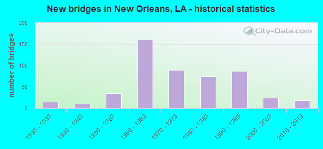
- New bridges - historical statistics
- 11910-1919
- 11920-1929
- 151930-1939
- 101940-1949
- 351950-1959
- 1601960-1969
- 901970-1979
- 741980-1989
- 871990-1999
- 242000-2009
- 192010-2019
- 12020-2022
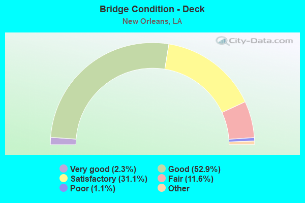
- Bridge Condition - Deck
- 2.3%Very good
- 52.9%Good
- 31.1%Satisfactory
- 11.6%Fair
- 1.1%Poor
- 1.1%Serious
- 0.8%Failed
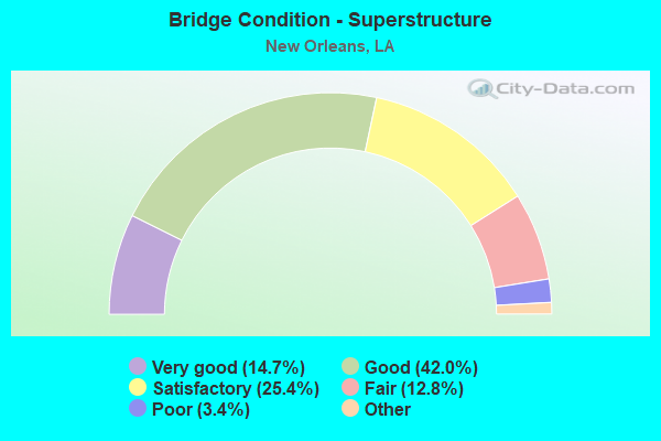
- Bridge Condition - Superstructure
- 14.7%Very good
- 42.0%Good
- 25.4%Satisfactory
- 12.8%Fair
- 3.4%Poor
- 1.7%Serious
- 0.2%Imminent failure
- 0.8%Failed
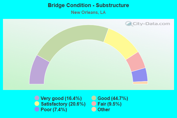
- Bridge Condition - Substructure
- 16.4%Very good
- 44.7%Good
- 20.6%Satisfactory
- 9.5%Fair
- 7.4%Poor
- 1.5%Serious
- 0.2%Imminent failure
- 0.8%Failed
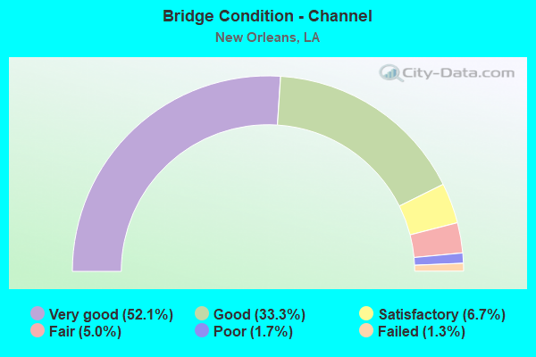
- Bridge Condition - Channel
- 52.1%Very good
- 33.3%Good
- 6.7%Satisfactory
- 5.0%Fair
- 1.7%Poor
- 1.3%Failed
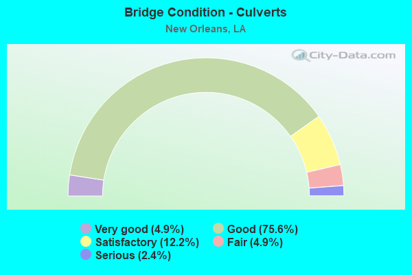
- Bridge Condition - Culverts
- 4.9%Very good
- 75.6%Good
- 12.2%Satisfactory
- 4.9%Fair
- 2.4%Serious
Find on map >> Show street view
Structure Number: 23600060600001, Location: 8.7 MILES EAST OF CHEF PA (Lat: 30.165061, Lng: -89.739700), Route carried "on" structure: US 90, Year Built: 2008, Status: Open, Structure Length: 155.27m (509.42ft), Average Daily Traffic: 1,410 (year 2016), Truck Traffic: 20%, Average Future Daily Traffic: 2,499 (year 2036), Design Load: HS 20, Features Intersected: RIGOLETS PASS
Minimum Vertical Clearance: 30+ m (98+ ft), Kilometerpoint: 0.000, Lanes on structure: 2, Base Highway Network: Yes (Inventory Route: 6-06-1, Subroute: 10), Owner: State Highway Agency, Approaching Roadway Width: 13.4m (44.0ft), Skew: 30 degrees, Navigation Control: Yes ( Vertical Clearance: 19.8m (65.0ft), Horizontal Clearance: 69.8m (229.0ft)), Material/Design: Prestressed concrete, Design/Construction: Stringer/Multi-beam, Number Of Spans In Main Unit: 35, Number Of Approach Spans: 18, Length of Maximum Span: 79.2m (259.8ft), Curb-To-Curb Width: 13.5m (44.3ft), Out-to-Out Width: 14.3m (46.9ft)
Condition: Deck: Good, Superstructure: Very good, Substructure: Good, Channel: Good, Operating Rating: 30.8 metric tons, Method Used To Determine Operating Rating: Load and Resistance Factor Rating (LRFR) rating reported by rating factor(RF) method using HL-93 loadings, Inventory Rating: 23.7 metric tons, Method Used To Determine Inventory Rating: Load and Resistance Factor Rating (LRFR) rating reported by rating factor(RF) method using HL-93 loadings, Structural Evaluation: Equal to present minimum criteria, Deck Geometry: Superior to present desirable criteria, Waterway Adequacy: Equal to present desirable criteria, Approach Roadway Alignment: Equal to present minimum criteria, Designated Inspection Frequency: Every 24 months, Underwater Inspection Frequency: Every 60 months, Inspection Date: August 2020, Underwater Inspection Date: October 2017, Deck Structure Type: Concrete Cast-file-Place, Wearing Surface/Protective System: Wearing Surface: Monolithic Concrete
Find on map >> Show street view
Structure Number: 23600069001041, Location: 0.50 M NORTH OF I-10 (Lat: 30.006850, Lng: -90.032200), Route carried "on" structure: US 90, Year Built: 1989, Status: Open, Structure Length: 99.67m (327.00ft), Average Daily Traffic: 33,300 (year 2016), Truck Traffic: 10%, Average Future Daily Traffic: 44,710 (year 2036), Design Load: HS 20, Features Intersected: IND CL/FRANCE RD/N.O. RR
Minimum Vertical Clearance: 5.74m (18.83ft), Kilometerpoint: 1.690, Lanes on structure: 6, Lanes under structure: 10, Base Highway Network: Yes (Inventory Route: 6-90-1, Subroute: 10), Owner: State Highway Agency, Approaching Roadway Width: 28.7m (94.2ft), Skew: 30 degrees, Navigation Control: Yes ( Vertical Clearance: 30.5m (100.1ft), Horizontal Clearance: 95.4m (313.0ft)), Material/Design: Steel, Design/Construction: Movable - Lift, Number Of Spans In Main Unit: 1, Number Of Approach Spans: 58, Length of Maximum Span: 100.6m (330.1ft), Curb-To-Curb Width: 27.1m (88.9ft), Out-to-Out Width: 28.3m (92.8ft)
Condition: Deck: Fair, Superstructure: Satisfactory, Substructure: Good, Channel: Very good, Operating Rating: 38.6 metric tons, Method Used To Determine Operating Rating: Load and Resistance Factor Rating (LRFR) rating reported by rating factor(RF) method using HL-93 loadings, Inventory Rating: 26.6 metric tons, Method Used To Determine Inventory Rating: Load and Resistance Factor Rating (LRFR) rating reported by rating factor(RF) method using HL-93 loadings, Structural Evaluation: Equal to present minimum criteria, Deck Geometry: Better than present minimum criteria, Underclear: Meets minimum limits, Waterway Adequacy: Equal to present desirable criteria, Approach Roadway Alignment: Equal to present desirable criteria, Designated Inspection Frequency: Every 24 months, Critical Feature Inspection Frequency: Every 24 months, Underwater Inspection Frequency: Every 60 months, Inspection Date: January 2020, Critical Feature Inspection Date: January 2020, Underwater Inspection Date: November 2017, Deck Structure Type: Concrete Cast-file-Place
Find on map >> Show street view
Structure Number: 23600069001218, Location: 0.50 M NORTH OF I-10 (Lat: 30.007961, Lng: -90.029300), Route carried "on" structure: Ramp US 90, Year Built: 1989, Status: Open, Structure Length: 22.43m (73.59ft), Average Daily Traffic: 3,330 (year 2016), Truck Traffic: 10%, Average Future Daily Traffic: 4,471 (year 2036), Design Load: HS 20, Features Intersected: FRANCE RD/N.O. BELT R/R
Minimum Vertical Clearance: 30+ m (98+ ft), Kilometerpoint: 0.100, Lanes on structure: 1, Lanes under structure: 4, Owner: State Highway Agency, Approaching Roadway Width: 7.9m (25.9ft), Material/Design: Steel, Design/Construction: Girder and Floorbeam System, Number Of Spans In Main Unit: 6, Number Of Approach Spans: 8, Length of Maximum Span: 43.9m (144.0ft), Curb-To-Curb Width: 7.9m (25.9ft), Out-to-Out Width: 8.9m (29.2ft)
Condition: Deck: Good, Superstructure: Good, Substructure: Good, Operating Rating: 69.8 metric tons, Method Used To Determine Operating Rating: Load Factor (LF), Inventory Rating: 41.7 metric tons, Method Used To Determine Inventory Rating: Load Factor (LF), Structural Evaluation: Better than present minimum criteria, Deck Geometry: Equal to present desirable criteria, Underclear: Somewhat better than minimum adequacy, Approach Roadway Alignment: Equal to present minimum criteria, Designated Inspection Frequency: Every 24 months, Inspection Date: Febuary 2020, Deck Structure Type: Concrete Cast-file-Place
Find on map >> Show street view
Structure Number: 23600069001235, Location: 0.50 M NORTH OF I-10 (Lat: 30.007511, Lng: -90.028400), Route carried "on" structure: Ramp US 90, Year Built: 1989, Status: Open, Structure Length: 30.45m (99.90ft), Average Daily Traffic: 3,330 (year 2016), Truck Traffic: 10%, Average Future Daily Traffic: 4,471 (year 2036), Design Load: HS 20, Features Intersected: RAMP A
Minimum Vertical Clearance: 30+ m (98+ ft), Kilometerpoint: 0.145, Lanes on structure: 1, Owner: State Highway Agency, Approaching Roadway Width: 7.9m (25.9ft), Material/Design: Steel continuous, Design/Construction: Girder and Floorbeam System, Number Of Spans In Main Unit: 10, Number Of Approach Spans: 10, Length of Maximum Span: 31.7m (104.0ft), Curb-To-Curb Width: 7.9m (25.9ft), Out-to-Out Width: 8.8m (28.9ft)
Condition: Deck: Good, Superstructure: Good, Substructure: Good, Operating Rating: 60.8 metric tons, Method Used To Determine Operating Rating: Load Factor (LF), Inventory Rating: 36.3 metric tons, Method Used To Determine Inventory Rating: Load Factor (LF), Structural Evaluation: Better than present minimum criteria, Deck Geometry: Equal to present desirable criteria, Approach Roadway Alignment: Equal to present minimum criteria, Designated Inspection Frequency: Every 24 months, Inspection Date: Febuary 2020, Deck Structure Type: Wood or Timber
Find on map >> Show street view
Structure Number: 23600069010641, Location: 9.9 MI NORTH OF I-10 (Lat: 30.052061, Lng: -89.880400), Route carried "on" structure: US 90, Year Built: 1965, Status: Open, Structure Length: 1.10m (3.61ft), Average Daily Traffic: 5,300 (year 2016), Truck Traffic: 20%, Average Future Daily Traffic: 8,330 (year 2036), Design Load: HS 20, Features Intersected: DRAIN CANAL
Minimum Vertical Clearance: 30+ m (98+ ft), Kilometerpoint: 17.281, Lanes on structure: 4, Base Highway Network: Yes (Inventory Route: 6-90-1, Subroute: 10), Owner: State Highway Agency, Approaching Roadway Width: 14.6m (47.9ft), Skew: 20 degrees, Material/Design: Concrete, Design/Construction: Culvert, Number Of Spans In Main Unit: 3, Length of Maximum Span: 3.0m (9.8ft), Curb-To-Curb Width: 14.6m (47.9ft), Out-to-Out Width: 32.9m (107.9ft)
Condition: Channel: Fair, Culverts: Satisfactory, Operating Rating: 42.1 metric tons, Method Used To Determine Operating Rating: Load and Resistance Factor Rating (LRFR) rating reported by rating factor(RF) method using HL-93 loadings, Inventory Rating: 32.4 metric tons, Method Used To Determine Inventory Rating: Load and Resistance Factor Rating (LRFR) rating reported by rating factor(RF) method using HL-93 loadings, Structural Evaluation: Equal to present minimum criteria, Deck Geometry: High priority of replacement, Waterway Adequacy: Equal to present desirable criteria, Approach Roadway Alignment: Equal to present desirable criteria, Length Of Structure Improvement: 1.74m (5.71ft), Designated Inspection Frequency: Every 24 months, Underwater Inspection Frequency: Every 60 months, Inspection Date: January 2020, Underwater Inspection Date: Febuary 2019, Bridge Improvement Cost: $177,000, Total Project Cost: $265,000 ( Estimate for 2016), Deck Structure Type: Concrete Cast-file-Place
Find on map >> Show street view
Structure Number: 23600070101061, Location: US 61 OVER I-10 (Lat: 29.969450, Lng: -90.107400), Route carried "on" structure: US 61, Year Built: 1940, Status: Posted for load, Structure Length: 43.95m (144.19ft), Average Daily Traffic: 19,200 (year 2018), Truck Traffic: 10%, Average Future Daily Traffic: 36,550 (year 2036), Design Load: HS 20, Features Intersected: I-10
Minimum Vertical Clearance: 5.26m (17.26ft), Kilometerpoint: 1.835, Lanes on structure: 4, Lanes under structure: 7, Base Highway Network: Yes (Inventory Route: 7-01-1, Subroute: 10), Owner: State Highway Agency, Approaching Roadway Width: 23.2m (76.1ft), Skew: 20 degrees, Material/Design: Steel, Design/Construction: Stringer/Multi-beam, Number Of Spans In Main Unit: 28, Number Of Approach Spans: 9, Length of Maximum Span: 25.0m (82.0ft), Curb-To-Curb Width: 18.3m (60.0ft), Out-to-Out Width: 20.7m (67.9ft)
Condition: Deck: Fair, Superstructure: Poor, Substructure: Poor, Operating Rating: 20.4 metric tons, Method Used To Determine Operating Rating: Load and Resistance Factor Rating (LRFR) rating reported by rating factor(RF) method using HL-93 loadings, Inventory Rating: 15.9 metric tons, Method Used To Determine Inventory Rating: Load and Resistance Factor Rating (LRFR) rating reported by rating factor(RF) method using HL-93 loadings, Structural Evaluation: High priority of replacement, Deck Geometry: Somewhat better than minimum adequacy, Underclear: Meets minimum limits, Approach Roadway Alignment: Equal to present minimum criteria, Bridge Posting: Required (Relationship of Operating Rating to Maximum Legal Load: 20.0 - 29.9% below), Length Of Structure Improvement: 43.95m (144.19ft), Designated Inspection Frequency: Every 12 months, Critical Feature Inspection Frequency: Every 12 months, Inspection Date: Febuary 2021, Critical Feature Inspection Date: Febuary 2021, Bridge Improvement Cost: $5,623,000, Total Project Cost: $8,434,000 ( Estimate for 2016), Deck Structure Type: Concrete Cast-file-Place, Wearing Surface/Protective System: Wearing Surface: Monolithic Concrete
Find on map >> Show street view
Structure Number: 23600070101701, Location: .6 MI EAST OF I-10 (Lat: 29.971600, Lng: -90.116900), Route carried "on" structure: US 61, Year Built: 1939, Status: Open, Structure Length: 4.08m (13.39ft), Average Daily Traffic: 18,150 (year 2016), Truck Traffic: 10%, Average Future Daily Traffic: 34,986 (year 2036), Design Load: H 15, Features Intersected: METAIRIE RELIEF CANAL
Minimum Vertical Clearance: 30+ m (98+ ft), Kilometerpoint: 2.799, Lanes on structure: 4, Base Highway Network: Yes (Inventory Route: 7-01-1, Subroute: 10), Owner: State Highway Agency, Approaching Roadway Width: 13.1m (43.0ft), Skew: 14 degrees, Material/Design: Steel, Design/Construction: Stringer/Multi-beam, Number Of Spans In Main Unit: 5, Length of Maximum Span: 10.7m (35.1ft), Curb or Sidewalk Widths: Left: 0.0m, Right: 1.9m (6.2ft), Curb-To-Curb Width: 12.8m (42.0ft), Out-to-Out Width: 15.5m (50.9ft)
Condition: Deck: Fair, Superstructure: Satisfactory, Substructure: Satisfactory, Channel: Very good, Operating Rating: 39.0 metric tons, Method Used To Determine Operating Rating: Load Factor (LF), Inventory Rating: 23.6 metric tons, Method Used To Determine Inventory Rating: Load Factor (LF), Structural Evaluation: Somewhat better than minimum adequacy, Deck Geometry: High priority of replacement, Waterway Adequacy: Equal to present desirable criteria, Approach Roadway Alignment: Equal to present desirable criteria, Length Of Structure Improvement: 5.00m (16.40ft), Designated Inspection Frequency: Every 24 months, Critical Feature Inspection Frequency: Every 24 months, Inspection Date: December 2021, Critical Feature Inspection Date: December 2021, Bridge Improvement Cost: $447,000, Total Project Cost: $670,000 ( Estimate for 2016), Deck Structure Type: Concrete Cast-file-Place
Find on map >> Show street view
Structure Number: 23600070101702, Location: 0.6 MI. WEST OF I-10 (Lat: 29.971450, Lng: -90.117089), Route carried "on" structure: US 61, Year Built: 1939, Status: Open, Structure Length: 4.08m (13.39ft), Average Daily Traffic: 18,150 (year 2016), Truck Traffic: 10%, Average Future Daily Traffic: 34,986 (year 2036), Design Load: H 15, Features Intersected: METAIRIE RELIEF CANAL
Minimum Vertical Clearance: 30+ m (98+ ft), Kilometerpoint: 0.887, Lanes on structure: 4, Base Highway Network: Yes (Inventory Route: 7-01-2, Subroute: 10), Owner: State Highway Agency, Approaching Roadway Width: 13.1m (43.0ft), Skew: 34 degrees, Material/Design: Steel, Design/Construction: Stringer/Multi-beam, Number Of Spans In Main Unit: 5, Length of Maximum Span: 10.7m (35.1ft), Curb or Sidewalk Widths: Left: 0.0m, Right: 1.2m (3.9ft), Curb-To-Curb Width: 12.8m (42.0ft), Out-to-Out Width: 15.5m (50.9ft)
Condition: Deck: Fair, Superstructure: Satisfactory, Substructure: Fair, Channel: Very good, Operating Rating: 39.0 metric tons, Method Used To Determine Operating Rating: Load Factor (LF), Inventory Rating: 23.6 metric tons, Method Used To Determine Inventory Rating: Load Factor (LF), Structural Evaluation: Somewhat better than minimum adequacy, Deck Geometry: High priority of replacement, Waterway Adequacy: Equal to present desirable criteria, Approach Roadway Alignment: Equal to present desirable criteria, Length Of Structure Improvement: 5.00m (16.40ft), Designated Inspection Frequency: Every 24 months, Critical Feature Inspection Frequency: Every 24 months, Inspection Date: December 2021, Critical Feature Inspection Date: December 2021, Bridge Improvement Cost: $447,000, Total Project Cost: $670,000 ( Estimate for 2016), Deck Structure Type: Concrete Cast-file-Place, Wearing Surface/Protective System: Wearing Surface: Monolithic Concrete
Find on map >> Show street view
Structure Number: 23600180104021, Location: 4.02 MI NORTH OF US 90 (Lat: 30.130689, Lng: -89.867300), Route carried "on" structure: US 11, Year Built: 1978, Status: Open, Structure Length: 3.66m (12.01ft), Average Daily Traffic: 3,300 (year 2016), Truck Traffic: 20%, Average Future Daily Traffic: 5,440 (year 2036), Design Load: HS 20, Features Intersected: DRAIN CANAL
Minimum Vertical Clearance: 30+ m (98+ ft), Kilometerpoint: 6.497, Lanes on structure: 2, Base Highway Network: Yes (Inventory Route: 18-01-1, Subroute: 10), Owner: State Highway Agency, Approaching Roadway Width: 14.3m (46.9ft), Material/Design: Concrete, Design/Construction: Slab, Number Of Spans In Main Unit: 6, Length of Maximum Span: 6.1m (20.0ft), Curb-To-Curb Width: 12.2m (40.0ft), Out-to-Out Width: 13.0m (42.7ft)
Condition: Deck: Fair, Superstructure: Fair, Substructure: Satisfactory, Channel: Good, Operating Rating: 66.2 metric tons, Method Used To Determine Operating Rating: Load Factor (LF), Inventory Rating: 39.9 metric tons, Method Used To Determine Inventory Rating: Load Factor (LF), Structural Evaluation: Somewhat better than minimum adequacy, Deck Geometry: Equal to present minimum criteria, Waterway Adequacy: Equal to present desirable criteria, Approach Roadway Alignment: Better than present minimum criteria, Designated Inspection Frequency: Every 24 months, Underwater Inspection Frequency: Every 60 months, Inspection Date: January 2021, Underwater Inspection Date: January 2019, Deck Structure Type: Concrete Cast-file-Place
Find on map >> Show street view
Structure Number: 23600180104831, Location: 4.83 MI NORTH OF US 90 (Lat: 30.141200, Lng: -89.864039), Route carried "on" structure: US 11, Year Built: 1978, Status: Open, Structure Length: 10.36m (33.99ft), Average Daily Traffic: 3,300 (year 2016), Truck Traffic: 20%, Average Future Daily Traffic: 5,440 (year 2036), Design Load: HS 20, Features Intersected: IRISH BAYOU
Minimum Vertical Clearance: 30+ m (98+ ft), Kilometerpoint: 7.707, Lanes on structure: 2, Base Highway Network: Yes (Inventory Route: 18-01-1, Subroute: 10), Owner: State Highway Agency, Approaching Roadway Width: 13.4m (44.0ft), Material/Design: Concrete, Design/Construction: Slab, Number Of Spans In Main Unit: 17, Length of Maximum Span: 6.1m (20.0ft), Curb-To-Curb Width: 12.2m (40.0ft), Out-to-Out Width: 13.0m (42.7ft)
Condition: Deck: Fair, Superstructure: Fair, Substructure: Poor, Channel: Good, Operating Rating: 45.4 metric tons, Method Used To Determine Operating Rating: Load and Resistance Factor Rating (LRFR) rating reported by rating factor(RF) method using HL-93 loadings, Inventory Rating: 35.0 metric tons, Method Used To Determine Inventory Rating: Load and Resistance Factor Rating (LRFR) rating reported by rating factor(RF) method using HL-93 loadings, Structural Evaluation: Meets minimum limits, Deck Geometry: Equal to present minimum criteria, Waterway Adequacy: Equal to present desirable criteria, Approach Roadway Alignment: Equal to present desirable criteria, Length Of Structure Improvement: 11.28m (37.01ft), Designated Inspection Frequency: Every 24 months, Underwater Inspection Frequency: Every 60 months, Other Special Inspection Frequency: Every 12 months, Inspection Date: November 2021, Underwater Inspection Date: January 2019, Other Special Inspection Date: November 2020, Bridge Improvement Cost: $962,000, Total Project Cost: $1,443,000 ( Estimate for 2016), Deck Structure Type: Concrete Cast-file-Place
Find on map >> Show street view
Structure Number: 23600180105351, Location: 5.35 MI NORTH OF US 90 (Lat: 30.148581, Lng: -89.859081), Route carried "on" structure: US 11, Year Built: 1967, Status: Open, Structure Length: 52.73m (173.00ft), Average Daily Traffic: 3,300 (year 2016), Truck Traffic: 20%, Average Future Daily Traffic: 5,440 (year 2036), Design Load: HS 20, Features Intersected: US 11 OVER I-10
Minimum Vertical Clearance: 30+ m (98+ ft), Kilometerpoint: 8.660, Lanes on structure: 2, Lanes under structure: 6, Base Highway Network: Yes (Inventory Route: 18-01-1, Subroute: 10), Owner: State Highway Agency, Approaching Roadway Width: 11.6m (38.1ft), Material/Design: Steel, Design/Construction: Stringer/Multi-beam, Number Of Spans In Main Unit: 2, Number Of Approach Spans: 21, Length of Maximum Span: 55.8m (183.1ft), Curb-To-Curb Width: 8.5m (27.9ft), Out-to-Out Width: 21.9m (71.9ft)
Condition: Deck: Satisfactory, Superstructure: Satisfactory, Substructure: Satisfactory, Operating Rating: 50.8 metric tons, Method Used To Determine Operating Rating: Load Factor (LF), Inventory Rating: 30.8 metric tons, Method Used To Determine Inventory Rating: Load Factor (LF), Structural Evaluation: Equal to present minimum criteria, Deck Geometry: Meets minimum limits, Underclear: Equal to present minimum criteria, Approach Roadway Alignment: Equal to present minimum criteria, Designated Inspection Frequency: Every 24 months, Critical Feature Inspection Frequency: Every 24 months, Inspection Date: March 2020, Critical Feature Inspection Date: March 2020, Deck Structure Type: Concrete Cast-file-Place
Find on map >> Show street view
Structure Number: 23600180200001, Location: .01 MI NORTH OF I-10 (Lat: 30.155439, Lng: -89.856069), Route carried "on" structure: US 11, Year Built: 1938, Status: Closed, Structure Length: 759.62m (2492.19ft), Average Daily Traffic: 6,800 (year 2015), Truck Traffic: 10%, Average Future Daily Traffic: 11,560 (year 2036), Design Load: H 15, Features Intersected: LAKE PONTCHARTRAIN
Minimum Vertical Clearance: 30+ m (98+ ft), Kilometerpoint: 0.006, Lanes on structure: 2, Base Highway Network: Yes (Inventory Route: 18-02-1, Subroute: 10), Owner: State Highway Agency, Approaching Roadway Width: 12.5m (41.0ft), Navigation Control: Yes ( Vertical Clearance: 304.5m (999.0ft), Horizontal Clearance: 46.6m (152.9ft)), Material/Design: Steel, Design/Construction: Movable - Bascule, Number Of Spans In Main Unit: 702, Length of Maximum Span: 45.7m (149.9ft), Curb-To-Curb Width: 9.1m (29.9ft), Out-to-Out Width: 10.2m (33.5ft)
Condition: Deck: Satisfactory, Superstructure: Imminent failure, Substructure: Imminent failure, Channel: Very good, Operating Rating: 2.3 metric tons, Method Used To Determine Operating Rating: Load and Resistance Factor Rating (LRFR) rating reported by rating factor(RF) method using HL-93 loadings, Inventory Rating: 1.9 metric tons, Method Used To Determine Inventory Rating: Load and Resistance Factor Rating (LRFR) rating reported by rating factor(RF) method using HL-93 loadings, Deck Geometry: Meets minimum limits, Waterway Adequacy: Equal to present desirable criteria, Approach Roadway Alignment: Equal to present desirable criteria, Bridge Posting: Required (Relationship of Operating Rating to Maximum Legal Load: > 39.9% below), Length Of Structure Improvement: 759.62m (2492.19ft), Designated Inspection Frequency: Every 24 months, Critical Feature Inspection Frequency: Every 24 months, Underwater Inspection Frequency: Every 60 months, Other Special Inspection Frequency: Every 6 months, Inspection Date: January 2020, Critical Feature Inspection Date: January 2020, Underwater Inspection Date: January 2020, Other Special Inspection Date: July 2021, Bridge Improvement Cost: $64,797,000, Total Project Cost: $97,195,000 ( Estimate for 2016), Deck Structure Type: Open Grating
Find on map >> Show street view
Structure Number: 23600460202211, Location: 2.21 MI SOUTH OF LA 39 (Lat: 29.964131, Lng: -90.028800), Route carried "on" structure: State highway 46, Year Built: 1960, Status: Open, Structure Length: 1.59m (5.22ft), Average Daily Traffic: 21,000 (year 2018), Truck Traffic: 10%, Average Future Daily Traffic: 37,060 (year 2036), Design Load: HS 20, Features Intersected: NO PUBLIC BELT R/R
Minimum Vertical Clearance: 30+ m (98+ ft), Kilometerpoint: 3.349, Lanes on structure: 4, Base Highway Network: Yes (Inventory Route: 46-02-1, Subroute: 10), Owner: County Highway Agency, Approaching Roadway Width: 18.3m (60.0ft), Skew: 30 degrees, Material/Design: Concrete, Design/Construction: Slab, Number Of Spans In Main Unit: 3, Length of Maximum Span: 5.2m (17.1ft), Curb or Sidewalk Widths: Left: 1.6m (5.2ft), Right: 1.6m (5.2ft), Curb-To-Curb Width: 14.6m (47.9ft), Out-to-Out Width: 18.3m (60.0ft)
Condition: Deck: Fair, Superstructure: Fair, Substructure: Poor, Operating Rating: 39.0 metric tons, Method Used To Determine Operating Rating: Load Factor (LF), Inventory Rating: 23.6 metric tons, Method Used To Determine Inventory Rating: Load Factor (LF), Structural Evaluation: Meets minimum limits, Deck Geometry: High priority of replacement, Underclear: High priority of replacement, Approach Roadway Alignment: Better than present minimum criteria, Length Of Structure Improvement: 2.29m (7.51ft), Designated Inspection Frequency: Every 12 months, Inspection Date: June 2021, Bridge Improvement Cost: $234,000, Total Project Cost: $351,000 ( Estimate for 2016), Deck Structure Type: Concrete Cast-file-Place, Wearing Surface/Protective System: Wearing Surface: Bituminous
Find on map >> Show street view
Structure Number: 23600460202341, Location: 2.34 MI SOUTH OF LA 39 (Lat: 29.963589, Lng: -90.026500), Route carried "on" structure: State highway 46, Year Built: 1960, Status: Open, Structure Length: 1.59m (5.22ft), Average Daily Traffic: 21,000 (year 2018), Truck Traffic: 10%, Average Future Daily Traffic: 37,060 (year 2036), Design Load: HS 20, Features Intersected: SISTER STREET
Minimum Vertical Clearance: 30+ m (98+ ft), Kilometerpoint: 3.582, Lanes on structure: 4, Lanes under structure: 1, Base Highway Network: Yes (Inventory Route: 46-02-1, Subroute: 10), Owner: State Highway Agency, Approaching Roadway Width: 18.3m (60.0ft), Skew: 30 degrees, Material/Design: Concrete, Design/Construction: Slab, Number Of Spans In Main Unit: 3, Length of Maximum Span: 5.2m (17.1ft), Curb or Sidewalk Widths: Left: 1.6m (5.2ft), Right: 1.6m (5.2ft), Curb-To-Curb Width: 14.6m (47.9ft), Out-to-Out Width: 18.3m (60.0ft)
Condition: Deck: Fair, Superstructure: Fair, Substructure: Poor, Operating Rating: 39.0 metric tons, Method Used To Determine Operating Rating: Load Factor (LF), Inventory Rating: 23.6 metric tons, Method Used To Determine Inventory Rating: Load Factor (LF), Structural Evaluation: Meets minimum limits, Deck Geometry: High priority of replacement, Underclear: High priority of replacement, Approach Roadway Alignment: Better than present minimum criteria, Length Of Structure Improvement: 2.29m (7.51ft), Designated Inspection Frequency: Every 12 months, Inspection Date: June 2021, Bridge Improvement Cost: $234,000, Total Project Cost: $351,000 ( Estimate for 2016), Deck Structure Type: Concrete Cast-file-Place, Wearing Surface/Protective System: Wearing Surface: Bituminous
Find on map >> Show street view
Structure Number: 23600463101201, Location: .6 MI EAST OF LA 3021 (Lat: 29.972661, Lng: -90.047800), Route carried "on" structure: State highway 39, Year Built: 1962, Status: Open, Structure Length: 40.45m (132.71ft), Average Daily Traffic: 17,100 (year 2016), Truck Traffic: 10%, Average Future Daily Traffic: 35,190 (year 2036), Design Load: HS 20, Features Intersected: N O P B RR (ROBERTSON ST
Minimum Vertical Clearance: 30+ m (98+ ft), Kilometerpoint: 1.738, Lanes on structure: 2, Lanes under structure: 2, Base Highway Network: Yes (Inventory Route: 46-31-1, Subroute: 10), Owner: State Highway Agency, Approaching Roadway Width: 8.5m (27.9ft), Skew: 20 degrees, Material/Design: Steel, Design/Construction: Stringer/Multi-beam, Number Of Spans In Main Unit: 19, Number Of Approach Spans: 14, Length of Maximum Span: 25.6m (84.0ft), Curb or Sidewalk Widths: Left: 1.5m (4.9ft), Right: 0.0m, Curb-To-Curb Width: 8.5m (27.9ft), Out-to-Out Width: 11.2m (36.7ft)
Condition: Deck: Satisfactory, Superstructure: Satisfactory, Substructure: Satisfactory, Operating Rating: 53.5 metric tons, Method Used To Determine Operating Rating: Load Factor (LF), Inventory Rating: 32.7 metric tons, Method Used To Determine Inventory Rating: Load Factor (LF), Structural Evaluation: Equal to present minimum criteria, Deck Geometry: High priority of corrective action, Underclear: High priority of replacement, Approach Roadway Alignment: Equal to present desirable criteria, Length Of Structure Improvement: 40.45m (132.71ft), Designated Inspection Frequency: Every 24 months, Inspection Date: Febuary 2021, Bridge Improvement Cost: $3,450,000, Total Project Cost: $5,175,000 ( Estimate for 2016), Deck Structure Type: Concrete Cast-file-Place
Find on map >> Show street view
Structure Number: 23600463101202, Location: .6 MI EAST OF LA 3021 (Lat: 29.972889, Lng: -90.043500), Route carried "on" structure: State highway 39, Year Built: 1949, Status: Open, Structure Length: 35.84m (117.59ft), Average Daily Traffic: 17,100 (year 2016), Truck Traffic: 10%, Average Future Daily Traffic: 35,190 (year 2036), Design Load: HS 20, Features Intersected: N O P B RR(CLAIBORNE AVE
Minimum Vertical Clearance: 30+ m (98+ ft), Kilometerpoint: 4.001, Lanes on structure: 2, Lanes under structure: 2, Base Highway Network: Yes (Inventory Route: 46-31-2, Subroute: 10), Owner: State Highway Agency, Approaching Roadway Width: 8.5m (27.9ft), Skew: 20 degrees, Material/Design: Steel, Design/Construction: Stringer/Multi-beam, Number Of Spans In Main Unit: 11, Number Of Approach Spans: 19, Length of Maximum Span: 24.1m (79.1ft), Curb or Sidewalk Widths: Left: 0.0m, Right: 1.5m (4.9ft), Curb-To-Curb Width: 8.5m (27.9ft), Out-to-Out Width: 11.5m (37.7ft)
Condition: Deck: Satisfactory, Superstructure: Fair, Substructure: Poor, Operating Rating: 52.6 metric tons, Method Used To Determine Operating Rating: Load Factor (LF), Inventory Rating: 31.7 metric tons, Method Used To Determine Inventory Rating: Load Factor (LF), Structural Evaluation: Meets minimum limits, Deck Geometry: High priority of corrective action, Underclear: High priority of replacement, Approach Roadway Alignment: Equal to present desirable criteria, Length Of Structure Improvement: 35.84m (117.59ft), Designated Inspection Frequency: Every 12 months, Inspection Date: December 2021, Bridge Improvement Cost: $3,057,000, Total Project Cost: $4,585,000 ( Estimate for 2016), Deck Structure Type: Concrete Cast-file-Place
Find on map >> Show street view
Structure Number: 23600463102221, Location: 1.6 MI EAST OF LA 3021 (Lat: 29.968769, Lng: -90.029400), Route carried "on" structure: State highway 39, Year Built: 1957, Status: Posted for load, Structure Length: 18.59m (60.99ft), Average Daily Traffic: 32,700 (year 2016), Truck Traffic: 10%, Average Future Daily Traffic: 53,210 (year 2036), Design Load: HS 20, Features Intersected: INDUSTRIAL CANAL
Minimum Vertical Clearance: 4.57m (14.99ft), Kilometerpoint: 3.568, Lanes on structure: 2, Lanes under structure: 4, Base Highway Network: Yes (Inventory Route: 46-31-1, Subroute: 10), Owner: State Highway Agency, Approaching Roadway Width: 8.2m (26.9ft), Skew: 30 degrees, Navigation Control: Yes ( Vertical Clearance: 48.8m (160.1ft), Horizontal Clearance: 99.1m (325.1ft)), Material/Design: Steel, Design/Construction: Girder and Floorbeam System, Number Of Spans In Main Unit: 10, Number Of Approach Spans: 7, Length of Maximum Span: 29.0m (95.1ft), Curb-To-Curb Width: 11.4m (37.4ft), Out-to-Out Width: 25.1m (82.3ft)
Condition: Deck: Satisfactory, Superstructure: Fair, Substructure: Satisfactory, Operating Rating: 36.3 metric tons, Method Used To Determine Operating Rating: Load Factor (LF), Inventory Rating: 26.3 metric tons, Method Used To Determine Inventory Rating: Load Factor (LF), Structural Evaluation: Somewhat better than minimum adequacy, Deck Geometry: Meets minimum limits, Underclear: Better than present minimum criteria, Approach Roadway Alignment: Better than present minimum criteria, Bridge Posting: Required (Relationship of Operating Rating to Maximum Legal Load: 20.0 - 29.9% below), Designated Inspection Frequency: Every 24 months, Critical Feature Inspection Frequency: Every 24 months, Inspection Date: September 2021, Critical Feature Inspection Date: September 2021, Deck Structure Type: Concrete Cast-file-Place, Wearing Surface/Protective System: Wearing Surface: Monolithic Concrete
Find on map >> Show street view
Structure Number: 23600463102222, Location: LA 39 (Lat: 29.969231, Lng: -90.027600), Route carried "on" structure: State highway 39, Year Built: 1957, Status: Posted for load, Structure Length: 18.44m (60.50ft), Average Daily Traffic: 16,350 (year 2016), Truck Traffic: 10%, Average Future Daily Traffic: 53,210 (year 2036), Design Load: HS 20, Features Intersected: INDUSTRIAL CANAL
Minimum Vertical Clearance: 4.57m (14.99ft), Kilometerpoint: 2.400, Lanes on structure: 2, Base Highway Network: Yes (Inventory Route: 46-31-2, Subroute: 10), Owner: State Highway Agency, Approaching Roadway Width: 8.2m (26.9ft), Skew: 30 degrees, Material/Design: Steel, Design/Construction: Stringer/Multi-beam, Number Of Spans In Main Unit: 9, Number Of Approach Spans: 7, Length of Maximum Span: 22.9m (75.1ft), Curb-To-Curb Width: 8.0m (26.2ft), Out-to-Out Width: 9.0m (29.5ft)
Condition: Deck: Satisfactory, Superstructure: Good, Substructure: Good, Operating Rating: 35.6 metric tons, Method Used To Determine Operating Rating: Load and Resistance Factor Rating (LRFR) rating reported by rating factor(RF) method using HL-93 loadings, Inventory Rating: 27.5 metric tons, Method Used To Determine Inventory Rating: Load and Resistance Factor Rating (LRFR) rating reported by rating factor(RF) method using HL-93 loadings, Structural Evaluation: Equal to present minimum criteria, Deck Geometry: High priority of replacement, Approach Roadway Alignment: Equal to present desirable criteria, Bridge Posting: Required (Relationship of Operating Rating to Maximum Legal Load: 20.0 - 29.9% below), Length Of Structure Improvement: 19.17m (62.89ft), Designated Inspection Frequency: Every 24 months, Critical Feature Inspection Frequency: Every 24 months, Inspection Date: November 2021, Critical Feature Inspection Date: November 2021, Bridge Improvement Cost: $1,635,000, Total Project Cost: $2,452,000 ( Estimate for 2016), Deck Structure Type: Concrete Cast-file-Place, Wearing Surface/Protective System: Wearing Surface: Monolithic Concrete
Find on map >> Show street view
Structure Number: 23600463102341, Location: LA 39 @ POLAND AVENUE (Lat: 29.969139, Lng: -90.027500), Route carried "on" structure: State highway 39, Year Built: 1957, Status: Posted for load, Structure Length: 46.79m (153.51ft), Average Daily Traffic: 32,700 (year 2016), Truck Traffic: 10%, Average Future Daily Traffic: 53,210 (year 2036), Design Load: HS 20, Features Intersected: INNER HARBOR NAV CANAL
Minimum Vertical Clearance: 4.60m (15.09ft), Kilometerpoint: 3.750, Lanes on structure: 4, Base Highway Network: Yes (Inventory Route: 46-31-1, Subroute: 10), Owner: State Highway Agency, Approaching Roadway Width: 8.2m (26.9ft), Skew: 30 degrees, Navigation Control: Yes ( Vertical Clearance: 48.8m (160.1ft), Horizontal Clearance: 93.0m (305.1ft)), Material/Design: Steel, Design/Construction: Movable - Lift, Number Of Spans In Main Unit: 1, Number Of Approach Spans: 22, Length of Maximum Span: 109.7m (359.9ft), Curb-To-Curb Width: 16.5m (54.1ft), Out-to-Out Width: 18.3m (60.0ft)
Condition: Deck: Fair, Superstructure: Poor, Substructure: Satisfactory, Channel: Good, Operating Rating: 24.0 metric tons, Method Used To Determine Operating Rating: Load and Resistance Factor Rating (LRFR) rating reported by rating factor(RF) method using HL-93 loadings, Inventory Rating: 18.5 metric tons, Method Used To Determine Inventory Rating: Load and Resistance Factor Rating (LRFR) rating reported by rating factor(RF) method using HL-93 loadings, Structural Evaluation: Meets minimum limits, Deck Geometry: Meets minimum limits, Waterway Adequacy: Equal to present desirable criteria, Approach Roadway Alignment: Equal to present minimum criteria, Bridge Posting: Required (Relationship of Operating Rating to Maximum Legal Load: 20.0 - 29.9% below), Designated Inspection Frequency: Every 12 months, Critical Feature Inspection Frequency: Every 12 months, Underwater Inspection Frequency: Every 60 months, Inspection Date: September 2021, Critical Feature Inspection Date: September 2021, Underwater Inspection Date: November 2017, Deck Structure Type: Open Grating
Find on map >> Show street view
Structure Number: 23600463102631, Location: LA 39 (Lat: 29.968111, Lng: -90.022900), Route carried "on" structure: State highway 39, Year Built: 1957, Status: Posted for load, Structure Length: 8.53m (27.99ft), Average Daily Traffic: 16,350 (year 2016), Truck Traffic: 10%, Average Future Daily Traffic: 53,210 (year 2036), Design Load: HS 20, Features Intersected: INDUSTRIAL CANAL
Minimum Vertical Clearance: 4.57m (14.99ft), Kilometerpoint: 4.220, Lanes on structure: 2, Base Highway Network: Yes (Inventory Route: 46-31-1, Subroute: 10), Owner: State Highway Agency, Approaching Roadway Width: 8.2m (26.9ft), Skew: 30 degrees, Material/Design: Concrete, Design/Construction: Slab, Number Of Spans In Main Unit: 14, Length of Maximum Span: 6.1m (20.0ft), Curb-To-Curb Width: 8.5m (27.9ft), Out-to-Out Width: 9.5m (31.2ft)
Condition: Deck: Fair, Superstructure: Fair, Substructure: Fair, Operating Rating: 23.0 metric tons, Method Used To Determine Operating Rating: Load and Resistance Factor Rating (LRFR) rating reported by rating factor(RF) method using HL-93 loadings, Inventory Rating: 17.8 metric tons, Method Used To Determine Inventory Rating: Load and Resistance Factor Rating (LRFR) rating reported by rating factor(RF) method using HL-93 loadings, Structural Evaluation: Meets minimum limits, Deck Geometry: High priority of corrective action, Approach Roadway Alignment: Equal to present desirable criteria, Bridge Posting: Required (Relationship of Operating Rating to Maximum Legal Load: 20.0 - 29.9% below), Length Of Structure Improvement: 9.45m (31.00ft), Designated Inspection Frequency: Every 24 months, Inspection Date: January 2022, Bridge Improvement Cost: $806,000, Total Project Cost: $1,209,000 ( Estimate for 2016), Deck Structure Type: Concrete Cast-file-Place, Wearing Surface/Protective System: Wearing Surface: Monolithic Concrete
Find on map >> Show street view
Structure Number: 23600463102632, Location: LA 39 (Lat: 29.968000, Lng: -90.022100), Route carried "on" structure: State highway 39, Year Built: 1957, Status: Posted for load, Structure Length: 8.53m (27.99ft), Average Daily Traffic: 16,350 (year 2016), Truck Traffic: 10%, Average Future Daily Traffic: 53,210 (year 2036), Design Load: HS 20, Features Intersected: INDUSTRIAL CANAL
Minimum Vertical Clearance: 4.57m (14.99ft), Kilometerpoint: 1.846, Lanes on structure: 2, Base Highway Network: Yes (Inventory Route: 46-31-2, Subroute: 10), Owner: State Highway Agency, Approaching Roadway Width: 8.2m (26.9ft), Skew: 30 degrees, Material/Design: Concrete, Design/Construction: Slab, Number Of Spans In Main Unit: 14, Length of Maximum Span: 6.1m (20.0ft), Curb-To-Curb Width: 8.5m (27.9ft), Out-to-Out Width: 9.5m (31.2ft)
Condition: Deck: Fair, Superstructure: Fair, Substructure: Fair, Operating Rating: 21.7 metric tons, Method Used To Determine Operating Rating: Load and Resistance Factor Rating (LRFR) rating reported by rating factor(RF) method using HL-93 loadings, Inventory Rating: 16.5 metric tons, Method Used To Determine Inventory Rating: Load and Resistance Factor Rating (LRFR) rating reported by rating factor(RF) method using HL-93 loadings, Structural Evaluation: Meets minimum limits, Deck Geometry: High priority of corrective action, Approach Roadway Alignment: Equal to present desirable criteria, Bridge Posting: Required (Relationship of Operating Rating to Maximum Legal Load: 20.0 - 29.9% below), Length Of Structure Improvement: 9.45m (31.00ft), Designated Inspection Frequency: Every 24 months, Inspection Date: January 2022, Bridge Improvement Cost: $806,000, Total Project Cost: $1,209,000 ( Estimate for 2016), Deck Structure Type: Concrete Cast-file-Place, Wearing Surface/Protective System: Wearing Surface: Monolithic Concrete
Find on map >> Show street view
Structure Number: 23601480200001, Location: 3.0 MI SOUTH OF I-10 (Lat: 29.981561, Lng: -89.945419), Route carried "on" structure: State highway 47, Year Built: 1973, Status: Open, Structure Length: 9.14m (29.99ft), Average Daily Traffic: 31,300 (year 2018), Truck Traffic: 10%, Average Future Daily Traffic: 47,770 (year 2036), Design Load: HS 20, Features Intersected: BAYOU BIENVENUE
Minimum Vertical Clearance: 30+ m (98+ ft), Kilometerpoint: 0.000, Lanes on structure: 4, Base Highway Network: Yes (Inventory Route: 148-02-1, Subroute: 10), Owner: State Highway Agency, Approaching Roadway Width: 27.4m (89.9ft), Skew: 30 degrees, Material/Design: Concrete, Design/Construction: Slab, Number Of Spans In Main Unit: 15, Length of Maximum Span: 6.1m (20.0ft), Curb-To-Curb Width: 20.7m (67.9ft), Out-to-Out Width: 28.1m (92.2ft)
Condition: Deck: Poor, Superstructure: Poor, Substructure: Poor, Channel: Satisfactory, Operating Rating: 30.5 metric tons, Method Used To Determine Operating Rating: Load and Resistance Factor Rating (LRFR) rating reported by rating factor(RF) method using HL-93 loadings, Inventory Rating: 23.7 metric tons, Method Used To Determine Inventory Rating: Load and Resistance Factor Rating (LRFR) rating reported by rating factor(RF) method using HL-93 loadings, Structural Evaluation: Meets minimum limits, Deck Geometry: Superior to present desirable criteria, Waterway Adequacy: Equal to present desirable criteria, Approach Roadway Alignment: Equal to present desirable criteria, Length Of Structure Improvement: 10.06m (33.01ft), Designated Inspection Frequency: Every 12 months, Underwater Inspection Frequency: Every 60 months, Inspection Date: January 2021, Underwater Inspection Date: Febuary 2019, Bridge Improvement Cost: $1,458,000, Total Project Cost: $2,187,000 ( Estimate for 2016), Deck Structure Type: Concrete Cast-file-Place
Find on map >> Show street view
Structure Number: 23601480201061, Location: 2.0 MI SOUTH OF I-10 (Lat: 29.996119, Lng: -89.939900), Route carried "on" structure: State highway 47, Year Built: 1967, Status: Open, Structure Length: 201.84m (662.20ft), Average Daily Traffic: 29,900 (year 2016), Truck Traffic: 10%, Average Future Daily Traffic: 47,770 (year 2036), Design Load: HS 20, Features Intersected: I C WATERWAY(GULF OUTLET
Minimum Vertical Clearance: 5.18m (16.99ft), Kilometerpoint: 1.711, Lanes on structure: 4, Lanes under structure: 4, Base Highway Network: Yes (Inventory Route: 148-02-1, Subroute: 10), Owner: State Highway Agency, Approaching Roadway Width: 19.8m (65.0ft), Skew: 30 degrees, Navigation Control: Yes ( Vertical Clearance: 41.1m (134.8ft), Horizontal Clearance: 152.4m (500.0ft)), Material/Design: Steel, Design/Construction: Truss - Thru, Number Of Spans In Main Unit: 3, Number Of Approach Spans: 66, Length of Maximum Span: 214.0m (702.1ft), Curb-To-Curb Width: 17.7m (58.1ft), Out-to-Out Width: 20.2m (66.3ft)
Condition: Deck: Good, Superstructure: Satisfactory, Substructure: Satisfactory, Channel: Very good, Operating Rating: 24.6 metric tons, Method Used To Determine Operating Rating: Load and Resistance Factor Rating (LRFR) rating reported by rating factor(RF) method using HL-93 loadings, Inventory Rating: 19.1 metric tons, Method Used To Determine Inventory Rating: Load and Resistance Factor Rating (LRFR) rating reported by rating factor(RF) method using HL-93 loadings, Structural Evaluation: Meets minimum limits, Deck Geometry: Somewhat better than minimum adequacy, Underclear: Superior to present desirable criteria, Waterway Adequacy: Equal to present desirable criteria, Approach Roadway Alignment: Equal to present desirable criteria, Designated Inspection Frequency: Every 24 months, Critical Feature Inspection Frequency: Every 24 months, Underwater Inspection Frequency: Every 60 months, Inspection Date: August 2020, Critical Feature Inspection Date: August 2020, Underwater Inspection Date: November 2017, Deck Structure Type: Concrete Cast-file-Place
Find on map >> Show street view
Structure Number: 23602830800411, Location: .4 MI SOUTH OF I-10 (Lat: 29.954031, Lng: -90.089100), Route carried "on" structure: Business US 90, Year Built: 1960, Status: Open, Structure Length: 149.26m (489.70ft), Average Daily Traffic: 87,600 (year 2016), Truck Traffic: 25%, Average Future Daily Traffic: 173,196 (year 2036), Design Load: HS 20, Features Intersected: R/R, CITY STS
Minimum Vertical Clearance: 30+ m (98+ ft), Kilometerpoint: 0.587, Lanes on structure: 2, Lanes under structure: 4, Base Highway Network: Yes (Inventory Route: 283-08-1, Subroute: 10), Owner: State Highway Agency, Approaching Roadway Width: 18.3m (60.0ft), Skew: 10 degrees, Material/Design: Steel, Design/Construction: Stringer/Multi-beam, Number Of Spans In Main Unit: 80, Number Of Approach Spans: 7, Length of Maximum Span: 54.0m (177.2ft), Curb-To-Curb Width: 12.2m (40.0ft), Out-to-Out Width: 13.7m (44.9ft)
Condition: Deck: Satisfactory, Superstructure: Satisfactory, Substructure: Satisfactory, Operating Rating: 56.2 metric tons, Method Used To Determine Operating Rating: Load Factor (LF), Inventory Rating: 33.6 metric tons, Method Used To Determine Inventory Rating: Load Factor (LF), Structural Evaluation: Equal to present minimum criteria, Deck Geometry: Better than present minimum criteria, Underclear: High priority of corrective action, Approach Roadway Alignment: Better than present minimum criteria, Designated Inspection Frequency: Every 24 months, Critical Feature Inspection Frequency: Every 24 months, Inspection Date: April 2020, Critical Feature Inspection Date: April 2020, Deck Structure Type: Concrete Cast-file-Place
Find on map >> Show street view
Structure Number: 23602830800412, Location: .4 MI SOUTH OF I-10 (Lat: 29.945619, Lng: -90.079400), Route carried "on" structure: Business US 90, Year Built: 1960, Status: Open, Structure Length: 136.58m (448.10ft), Average Daily Traffic: 87,600 (year 2016), Truck Traffic: 25%, Average Future Daily Traffic: 173,196 (year 2036), Design Load: HS 20, Features Intersected: R/R, CITY STS
Minimum Vertical Clearance: 30+ m (98+ ft), Kilometerpoint: 5.428, Lanes on structure: 2, Lanes under structure: 5, Base Highway Network: Yes (Inventory Route: 283-08-2, Subroute: 10), Owner: State Highway Agency, Approaching Roadway Width: 12.8m (42.0ft), Skew: 10 degrees, Material/Design: Steel, Design/Construction: Stringer/Multi-beam, Number Of Spans In Main Unit: 72, Number Of Approach Spans: 7, Length of Maximum Span: 54.0m (177.2ft), Curb-To-Curb Width: 12.2m (40.0ft), Out-to-Out Width: 13.7m (44.9ft)
Condition: Deck: Satisfactory, Superstructure: Satisfactory, Substructure: Good, Operating Rating: 39.0 metric tons, Method Used To Determine Operating Rating: Load Factor (LF), Inventory Rating: 27.2 metric tons, Method Used To Determine Inventory Rating: Load Factor (LF), Structural Evaluation: Equal to present minimum criteria, Deck Geometry: Better than present minimum criteria, Underclear: High priority of replacement, Approach Roadway Alignment: Equal to present desirable criteria, Length Of Structure Improvement: 136.58m (448.10ft), Designated Inspection Frequency: Every 24 months, Critical Feature Inspection Frequency: Every 24 months, Inspection Date: April 2020, Critical Feature Inspection Date: April 2020, Bridge Improvement Cost: $11,650,000, Total Project Cost: $17,475,000 ( Estimate for 2016), Deck Structure Type: Concrete Cast-file-Place
Find on map >> Show street view
Structure Number: 23602830800497, Location: .5 MI SOUTH OF I-10 (Lat: 29.952650, Lng: -90.087700), Route carried "on" structure: Ramp US 90, Year Built: 1960, Status: Open, Structure Length: 33.83m (110.99ft), Average Daily Traffic: 4,610 (year 2016), Truck Traffic: 10%, Average Future Daily Traffic: 6,868 (year 2036), Design Load: HS 20, Features Intersected: RAMPS
Minimum Vertical Clearance: 4.78m (15.68ft), Kilometerpoint: 0.108, Lanes on structure: 1, Lanes under structure: 1, Owner: State Highway Agency, Approaching Roadway Width: 9.1m (29.9ft), Material/Design: Steel, Design/Construction: Stringer/Multi-beam, Number Of Spans In Main Unit: 18, Number Of Approach Spans: 6, Length of Maximum Span: 18.3m (60.0ft), Curb-To-Curb Width: 6.4m (21.0ft), Out-to-Out Width: 7.8m (25.6ft)
Condition: Deck: Good, Superstructure: Good, Substructure: Good, Operating Rating: 68.0 metric tons, Method Used To Determine Operating Rating: Load Factor (LF), Inventory Rating: 40.8 metric tons, Method Used To Determine Inventory Rating: Load Factor (LF), Structural Evaluation: Better than present minimum criteria, Deck Geometry: Somewhat better than minimum adequacy, Underclear: High priority of corrective action, Approach Roadway Alignment: Equal to present desirable criteria, Designated Inspection Frequency: Every 24 months, Inspection Date: March 2020, Deck Structure Type: Concrete Cast-file-Place
Find on map >> Show street view
Structure Number: 23602830800525, Location: .52 MI SOUTH OF I-10 (Lat: 29.951561, Lng: -90.085000), Route carried "on" structure: Ramp US 90, Year Built: 1960, Status: Open, Structure Length: 42.37m (139.01ft), Average Daily Traffic: 13,000 (year 2016), Truck Traffic: 25%, Average Future Daily Traffic: 19,873 (year 2036), Design Load: HS 20, Features Intersected: RAMPS
Minimum Vertical Clearance: 30+ m (98+ ft), Kilometerpoint: 0.100, Lanes on structure: 1, Lanes under structure: 8, Owner: State Highway Agency, Approaching Roadway Width: 9.1m (29.9ft), Material/Design: Steel, Design/Construction: Stringer/Multi-beam, Number Of Spans In Main Unit: 29, Length of Maximum Span: 24.4m (80.1ft), Curb-To-Curb Width: 6.1m (20.0ft), Out-to-Out Width: 8.1m (26.6ft)
Condition: Deck: Good, Superstructure: Fair, Substructure: Satisfactory, Operating Rating: 33.7 metric tons, Method Used To Determine Operating Rating: Load and Resistance Factor Rating (LRFR) rating reported by rating factor(RF) method using HL-93 loadings, Inventory Rating: 25.9 metric tons, Method Used To Determine Inventory Rating: Load and Resistance Factor Rating (LRFR) rating reported by rating factor(RF) method using HL-93 loadings, Structural Evaluation: Somewhat better than minimum adequacy, Deck Geometry: Somewhat better than minimum adequacy, Approach Roadway Alignment: Equal to present minimum criteria, Designated Inspection Frequency: Every 24 months, Critical Feature Inspection Frequency: Every 24 months, Inspection Date: March 2020, Critical Feature Inspection Date: March 2020, Deck Structure Type: Concrete Cast-file-Place
Find on map >> Show street view
Structure Number: 23602830800565, Location: .56 MI SOUTH OF I-10 (Lat: 29.950681, Lng: -90.086000), Route carried "on" structure: Ramp US 90, Year Built: 1994, Status: Open, Structure Length: 14.57m (47.80ft), Average Daily Traffic: 13,000 (year 2016), Truck Traffic: 25%, Average Future Daily Traffic: 19,873 (year 2036), Design Load: HS 20, Features Intersected: EAST SERVICE ROAD
Minimum Vertical Clearance: 30+ m (98+ ft), Kilometerpoint: 0.039, Lanes on structure: 1, Lanes under structure: 2, Owner: State Highway Agency, Approaching Roadway Width: 6.7m (22.0ft), Material/Design: Steel continuous, Design/Construction: Stringer/Multi-beam, Number Of Spans In Main Unit: 3, Number Of Approach Spans: 8, Length of Maximum Span: 29.9m (98.1ft), Curb-To-Curb Width: 6.7m (22.0ft), Out-to-Out Width: 7.6m (24.9ft)
Condition: Deck: Good, Superstructure: Very good, Substructure: Good, Operating Rating: 51.7 metric tons, Method Used To Determine Operating Rating: Load Factor (LF), Inventory Rating: 30.8 metric tons, Method Used To Determine Inventory Rating: Load Factor (LF), Structural Evaluation: Better than present minimum criteria, Deck Geometry: Equal to present minimum criteria, Approach Roadway Alignment: Equal to present desirable criteria, Designated Inspection Frequency: Every 24 months, Inspection Date: March 2020, Deck Structure Type: Concrete Cast-file-Place, Wearing Surface/Protective System: Wearing Surface: Monolithic Concrete
Find on map >> Show street view
Structure Number: 23602830800566, Location: .56 MI SOUTH OF I-10 (Lat: 29.951650, Lng: -90.085300), Route carried "on" structure: Ramp US 90, Year Built: 1960, Status: Open, Structure Length: 10.88m (35.70ft), Average Daily Traffic: 13,000 (year 2016), Truck Traffic: 25%, Average Future Daily Traffic: 19,873 (year 2036), Design Load: HS 20, Features Intersected: ON RAMP US 90-B
Minimum Vertical Clearance: 30+ m (98+ ft), Kilometerpoint: 0.035, Lanes on structure: 1, Owner: State Highway Agency, Approaching Roadway Width: 9.1m (29.9ft), Material/Design: Steel, Design/Construction: Stringer/Multi-beam, Number Of Spans In Main Unit: 4, Number Of Approach Spans: 7, Length of Maximum Span: 13.1m (43.0ft), Curb-To-Curb Width: 6.4m (21.0ft), Out-to-Out Width: 7.8m (25.6ft)
Condition: Deck: Satisfactory, Superstructure: Good, Substructure: Good, Operating Rating: 68.0 metric tons, Method Used To Determine Operating Rating: Load Factor (LF), Inventory Rating: 40.8 metric tons, Method Used To Determine Inventory Rating: Load Factor (LF), Structural Evaluation: Better than present minimum criteria, Deck Geometry: Somewhat better than minimum adequacy, Approach Roadway Alignment: Equal to present minimum criteria, Designated Inspection Frequency: Every 24 months, Inspection Date: March 2020, Deck Structure Type: Concrete Cast-file-Place
Find on map >> Show street view
Structure Number: 23602830800648, Location: .64 MI SOUTH OF I-10 (Lat: 29.951650, Lng: -90.085461), Route carried "on" structure: Ramp US 90, Year Built: 1994, Status: Open, Structure Length: 32.74m (107.41ft), Average Daily Traffic: 13,000 (year 2016), Truck Traffic: 25%, Average Future Daily Traffic: 19,873 (year 2036), Design Load: HS 20, Features Intersected: CITY STS. & RAMPS
Minimum Vertical Clearance: 30+ m (98+ ft), Kilometerpoint: 0.034, Lanes on structure: 1, Lanes under structure: 1, Owner: State Highway Agency, Approaching Roadway Width: 8.8m (28.9ft), Material/Design: Prestressed concrete continuous, Design/Construction: Stringer/Multi-beam, Number Of Spans In Main Unit: 12, Length of Maximum Span: 30.5m (100.1ft), Curb-To-Curb Width: 8.8m (28.9ft), Out-to-Out Width: 9.8m (32.2ft)
Condition: Deck: Good, Superstructure: Very good, Substructure: Very good, Operating Rating: 59.0 metric tons, Method Used To Determine Operating Rating: Load Factor (LF), Inventory Rating: 31.7 metric tons, Method Used To Determine Inventory Rating: Load Factor (LF), Structural Evaluation: Better than present minimum criteria, Deck Geometry: Superior to present desirable criteria, Approach Roadway Alignment: Equal to present minimum criteria, Designated Inspection Frequency: Every 24 months, Inspection Date: March 2020, Deck Structure Type: Concrete Cast-file-Place, Wearing Surface/Protective System: Wearing Surface: Monolithic Concrete
Find on map >> Show street view
Structure Number: 23602830800677, Location: .67 MI SOUTH OF I-10 (Lat: 29.950639, Lng: -90.086500), Route carried "on" structure: Ramp US 90, Year Built: 1994, Status: Open, Structure Length: 28.80m (94.49ft), Average Daily Traffic: 4,610 (year 2016), Truck Traffic: 10%, Average Future Daily Traffic: 6,868 (year 2036), Design Load: HS 20, Features Intersected: CITY STS., RR
Minimum Vertical Clearance: 30+ m (98+ ft), Kilometerpoint: 0.195, Lanes on structure: 1, Lanes under structure: 7, Owner: State Highway Agency, Approaching Roadway Width: 7.6m (24.9ft), Material/Design: Steel, Design/Construction: Girder and Floorbeam System, Number Of Spans In Main Unit: 6, Number Of Approach Spans: 6, Length of Maximum Span: 55.2m (181.1ft), Curb-To-Curb Width: 7.6m (24.9ft), Out-to-Out Width: 8.5m (27.9ft)
Condition: Deck: Good, Superstructure: Good, Substructure: Good, Operating Rating: 67.1 metric tons, Method Used To Determine Operating Rating: Load Factor (LF), Inventory Rating: 39.9 metric tons, Method Used To Determine Inventory Rating: Load Factor (LF), Structural Evaluation: Better than present minimum criteria, Deck Geometry: Better than present minimum criteria, Approach Roadway Alignment: Better than present minimum criteria, Designated Inspection Frequency: Every 24 months, Inspection Date: March 2020, Deck Structure Type: Concrete Cast-file-Place, Wearing Surface/Protective System: Wearing Surface: Monolithic Concrete
Find on map >> Show street view
Structure Number: 23602830800696, Location: .69 MI SOUTH OF I-10 (Lat: 29.950211, Lng: -90.085300), Route carried "on" structure: Ramp US 90, Year Built: 1960, Status: Open, Structure Length: 16.25m (53.31ft), Average Daily Traffic: 4,610 (year 2016), Truck Traffic: 10%, Average Future Daily Traffic: 6,868 (year 2036), Design Load: HS 20, Features Intersected: RAMP B
Minimum Vertical Clearance: 4.57m (14.99ft), Kilometerpoint: 0.056, Lanes on structure: 1, Lanes under structure: 4, Owner: State Highway Agency, Approaching Roadway Width: 6.4m (21.0ft), Material/Design: Steel, Design/Construction: Stringer/Multi-beam, Number Of Spans In Main Unit: 6, Number Of Approach Spans: 8, Length of Maximum Span: 17.1m (56.1ft), Curb-To-Curb Width: 6.4m (21.0ft), Out-to-Out Width: 8.1m (26.6ft)
Condition: Deck: Good, Superstructure: Good, Substructure: Good, Operating Rating: 55.3 metric tons, Method Used To Determine Operating Rating: Load Factor (LF), Inventory Rating: 33.6 metric tons, Method Used To Determine Inventory Rating: Load Factor (LF), Structural Evaluation: Better than present minimum criteria, Deck Geometry: Somewhat better than minimum adequacy, Underclear: High priority of corrective action, Approach Roadway Alignment: Equal to present minimum criteria, Designated Inspection Frequency: Every 24 months, Inspection Date: March 2020, Deck Structure Type: Concrete Cast-file-Place
Find on map >> Show street view
Structure Number: 23602830800758, Location: .75 MI SOUTH OF I-10 (Lat: 29.950281, Lng: -90.084500), Route carried "on" structure: Ramp US 90, Year Built: 1960, Status: Open, Structure Length: 14.39m (47.21ft), Average Daily Traffic: 4,610 (year 2016), Truck Traffic: 10%, Average Future Daily Traffic: 6,868 (year 2036), Design Load: HS 20, Features Intersected: US 90-B W.OFF RAMP
Minimum Vertical Clearance: 30+ m (98+ ft), Kilometerpoint: 0.822, Lanes on structure: 1, Owner: State Highway Agency, Approaching Roadway Width: 6.7m (22.0ft), Material/Design: Steel, Design/Construction: Stringer/Multi-beam, Number Of Spans In Main Unit: 5, Number Of Approach Spans: 7, Length of Maximum Span: 17.4m (57.1ft), Curb-To-Curb Width: 6.4m (21.0ft), Out-to-Out Width: 8.1m (26.6ft)
Condition: Deck: Satisfactory, Superstructure: Good, Substructure: Good, Operating Rating: 68.0 metric tons, Method Used To Determine Operating Rating: Load Factor (LF), Inventory Rating: 40.8 metric tons, Method Used To Determine Inventory Rating: Load Factor (LF), Structural Evaluation: Better than present minimum criteria, Deck Geometry: Somewhat better than minimum adequacy, Approach Roadway Alignment: Equal to present minimum criteria, Designated Inspection Frequency: Every 24 months, Inspection Date: March 2020, Deck Structure Type: Concrete Cast-file-Place
Find on map >> Show street view
Structure Number: 23602830800778, Location: .77 MI SOUTH OF I-10 (Lat: 29.950150, Lng: -90.084700), Route carried "on" structure: Ramp US 90, Year Built: 1960, Status: Open, Structure Length: 19.29m (63.29ft), Average Daily Traffic: 4,610 (year 2016), Truck Traffic: 10%, Average Future Daily Traffic: 10,778 (year 2036), Design Load: HS 20, Features Intersected: S SERVICE RD/RAMP
Minimum Vertical Clearance: 30+ m (98+ ft), Kilometerpoint: 0.085, Lanes on structure: 1, Lanes under structure: 3, Owner: State Highway Agency, Approaching Roadway Width: 12.2m (40.0ft), Material/Design: Steel, Design/Construction: Stringer/Multi-beam, Number Of Spans In Main Unit: 13, Length of Maximum Span: 192.9m (632.9ft), Curb-To-Curb Width: 6.4m (21.0ft), Out-to-Out Width: 8.1m (26.6ft)
Condition: Deck: Satisfactory, Superstructure: Good, Substructure: Good, Operating Rating: 74.4 metric tons, Method Used To Determine Operating Rating: Load Factor (LF), Inventory Rating: 44.4 metric tons, Method Used To Determine Inventory Rating: Load Factor (LF), Structural Evaluation: Better than present minimum criteria, Deck Geometry: Somewhat better than minimum adequacy, Underclear: Meets minimum limits, Approach Roadway Alignment: Equal to present minimum criteria, Designated Inspection Frequency: Every 24 months, Inspection Date: March 2020, Deck Structure Type: Concrete Cast-file-Place
Find on map >> Show street view
Structure Number: 23602830800787, Location: .78 MI SOUTH OF I-10 (Lat: 29.949500, Lng: -90.084900), Route carried "on" structure: Ramp US 90, Year Built: 1994, Status: Open, Structure Length: 35.36m (116.01ft), Average Daily Traffic: 17,520 (year 2016), Truck Traffic: 25%, Average Future Daily Traffic: 28,866 (year 2036), Design Load: HS 20, Features Intersected: CITY STREETS
Minimum Vertical Clearance: 4.90m (16.08ft), Kilometerpoint: 0.072, Lanes on structure: 1, Lanes under structure: 6, Owner: State Highway Agency, Approaching Roadway Width: 6.7m (22.0ft), Material/Design: Steel, Design/Construction: Girder and Floorbeam System, Number Of Spans In Main Unit: 6, Number Of Approach Spans: 11, Length of Maximum Span: 45.4m (149.0ft), Curb-To-Curb Width: 6.7m (22.0ft), Out-to-Out Width: 7.6m (24.9ft)
Condition: Deck: Satisfactory, Superstructure: Good, Substructure: Satisfactory, Operating Rating: 52.6 metric tons, Method Used To Determine Operating Rating: Load Factor (LF), Inventory Rating: 30.8 metric tons, Method Used To Determine Inventory Rating: Load Factor (LF), Structural Evaluation: Equal to present minimum criteria, Deck Geometry: Somewhat better than minimum adequacy, Approach Roadway Alignment: Equal to present minimum criteria, Designated Inspection Frequency: Every 24 months, Inspection Date: March 2021, Deck Structure Type: Concrete Cast-file-Place, Wearing Surface/Protective System: Wearing Surface: Monolithic Concrete
Find on map >> Show street view
Structure Number: 23602830800915, Location: .91 MI SOUTH OF I-10 (Lat: 29.954581, Lng: -90.082900), Route carried "on" structure: Ramp US 90, Year Built: 1994, Status: Open, Structure Length: 111.77m (366.70ft), Average Daily Traffic: 17,010 (year 2016), Truck Traffic: 25%, Average Future Daily Traffic: 25,262 (year 2036), Design Load: HS 20, Features Intersected: CITY STS, I10 RAMPS, US9
Minimum Vertical Clearance: 30+ m (98+ ft), Kilometerpoint: 0.126, Lanes on structure: 2, Lanes under structure: 20, Owner: State Highway Agency, Approaching Roadway Width: 8.2m (26.9ft), Material/Design: Steel, Design/Construction: Girder and Floorbeam System, Number Of Spans In Main Unit: 26, Length of Maximum Span: 64.6m (211.9ft), Curb-To-Curb Width: 7.6m (24.9ft), Out-to-Out Width: 8.5m (27.9ft)
Condition: Deck: Good, Superstructure: Good, Substructure: Satisfactory, Operating Rating: 53.5 metric tons, Method Used To Determine Operating Rating: Load Factor (LF), Inventory Rating: 29.0 metric tons, Method Used To Determine Inventory Rating: Load Factor (LF), Structural Evaluation: Equal to present minimum criteria, Deck Geometry: High priority of replacement, Approach Roadway Alignment: Equal to present minimum criteria, Length Of Structure Improvement: 111.77m (366.70ft), Designated Inspection Frequency: Every 24 months, Inspection Date: August 2020, Bridge Improvement Cost: $9,534,000, Total Project Cost: $14,301,000 ( Estimate for 2016), Deck Structure Type: Concrete Cast-file-Place, Wearing Surface/Protective System: Wearing Surface: Monolithic Concrete
Find on map >> Show street view
Structure Number: 23602830800984, Location: .98 MI SOUTH OF I-10 (Lat: 29.947769, Lng: -90.082250), Route carried "on" structure: Alternate US 90, Year Built: 1996, Status: Open, Structure Length: 170.57m (559.61ft), Average Daily Traffic: 17,520 (year 2016), Truck Traffic: 13%, Average Future Daily Traffic: 28,866 (year 2036), Design Load: HS 20, Features Intersected: CITY STS.US.90BN/B RMPS
Minimum Vertical Clearance: 30+ m (98+ ft), Kilometerpoint: 1.761, Lanes on structure: 2, Lanes under structure: 20, Owner: State Highway Agency, Approaching Roadway Width: 9.8m (32.2ft), Material/Design: Steel, Design/Construction: Girder and Floorbeam System, Number Of Spans In Main Unit: 34, Number Of Approach Spans: 19, Length of Maximum Span: 75.3m (247.0ft), Curb-To-Curb Width: 9.8m (32.2ft), Out-to-Out Width: 10.7m (35.1ft)
Condition: Deck: Satisfactory, Superstructure: Satisfactory, Substructure: Satisfactory, Operating Rating: 68.0 metric tons, Method Used To Determine Operating Rating: Load Factor (LF), Inventory Rating: 32.7 metric tons, Method Used To Determine Inventory Rating: Load Factor (LF), Structural Evaluation: Equal to present minimum criteria, Deck Geometry: Meets minimum limits, Underclear: High priority of corrective action, Approach Roadway Alignment: Better than present minimum criteria, Designated Inspection Frequency: Every 24 months, Inspection Date: August 2020, Deck Structure Type: Concrete Cast-file-Place, Wearing Surface/Protective System: Wearing Surface: Monolithic Concrete
Find on map >> Show street view
Structure Number: 23602830801175, Location: 1.17 MI SOUTH OF I-10 (Lat: 29.943119, Lng: -90.075500), Route carried "on" structure: Ramp US 90, Year Built: 1960, Status: Open, Structure Length: 15.54m (50.98ft), Average Daily Traffic: 17,520 (year 2016), Truck Traffic: 25%, Average Future Daily Traffic: 28,866 (year 2036), Design Load: HS 20, Features Intersected: RAMP
Minimum Vertical Clearance: 30+ m (98+ ft), Kilometerpoint: 0.124, Lanes on structure: 1, Owner: State Highway Agency, Approaching Roadway Width: 6.1m (20.0ft), Material/Design: Steel continuous, Design/Construction: Stringer/Multi-beam, Number Of Spans In Main Unit: 4, Number Of Approach Spans: 5, Length of Maximum Span: 38.1m (125.0ft), Curb-To-Curb Width: 6.1m (20.0ft), Out-to-Out Width: 7.5m (24.6ft)
Condition: Deck: Good, Superstructure: Good, Substructure: Good, Operating Rating: 68.0 metric tons, Method Used To Determine Operating Rating: Load Factor (LF), Inventory Rating: 40.8 metric tons, Method Used To Determine Inventory Rating: Load Factor (LF), Structural Evaluation: Better than present minimum criteria, Deck Geometry: Somewhat better than minimum adequacy, Approach Roadway Alignment: Better than present minimum criteria, Designated Inspection Frequency: Every 24 months, Inspection Date: March 2020, Deck Structure Type: Concrete Cast-file-Place