Bridge Statistics for New Orleans, Louisiana (LA)
Condition, Traffic, Stress, Structural Evaluation, Project Costs
- National Bridge Inventory (NBI) Statistics
- 840Number of bridges
- 69,872ft / 21,297mTotal length
- $922,208,000Total costs
- 18,135,528Total average daily traffic
- 2,072,962Total average daily truck traffic
- National Bridge Inventory (NBI) Registered Bridges for New Orleans
- No street view available for this location
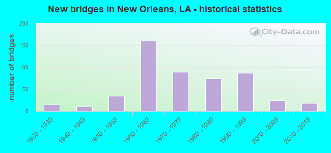
- New bridges - historical statistics
- 11910-1919
- 11920-1929
- 151930-1939
- 101940-1949
- 351950-1959
- 1601960-1969
- 901970-1979
- 741980-1989
- 871990-1999
- 242000-2009
- 192010-2019
- 12020-2022
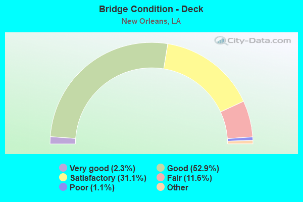
- Bridge Condition - Deck
- 2.3%Very good
- 52.9%Good
- 31.1%Satisfactory
- 11.6%Fair
- 1.1%Poor
- 1.1%Serious
- 0.8%Failed
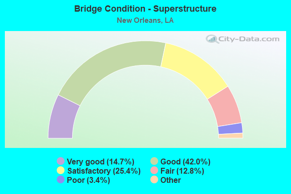
- Bridge Condition - Superstructure
- 14.7%Very good
- 42.0%Good
- 25.4%Satisfactory
- 12.8%Fair
- 3.4%Poor
- 1.7%Serious
- 0.2%Imminent failure
- 0.8%Failed
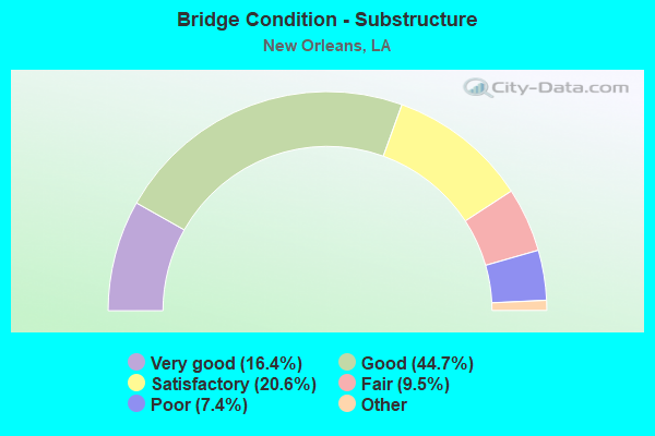
- Bridge Condition - Substructure
- 16.4%Very good
- 44.7%Good
- 20.6%Satisfactory
- 9.5%Fair
- 7.4%Poor
- 1.5%Serious
- 0.2%Imminent failure
- 0.8%Failed
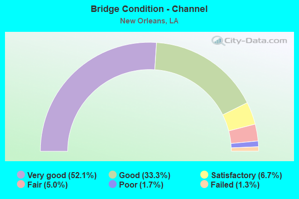
- Bridge Condition - Channel
- 52.1%Very good
- 33.3%Good
- 6.7%Satisfactory
- 5.0%Fair
- 1.7%Poor
- 1.3%Failed
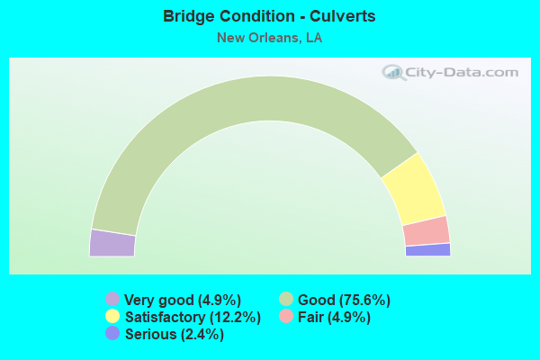
- Bridge Condition - Culverts
- 4.9%Very good
- 75.6%Good
- 12.2%Satisfactory
- 4.9%Fair
- 2.4%Serious
Find on map >> Show street view
Structure Number: 55200000620033, Location: 2.27 Mi. N. of US 90 (Lat: 30.195589, Lng: -89.754800), Route carried "on" structure: State highway 433, Year Built: 2019, Status: Open, Structure Length: 6.10m (20.01ft), Average Daily Traffic: 1,300 (year 2017), Truck Traffic: 15%, Average Future Daily Traffic: 2,736 (year 2036), Design Load: Greater than HL93, Features Intersected: Salt Bayou
Minimum Vertical Clearance: 30+ m (98+ ft), Kilometerpoint: 3.653, Lanes on structure: 2, Owner: State Highway Agency, Approaching Roadway Width: 9.8m (32.2ft), Material/Design: Concrete, Design/Construction: Slab, Number Of Spans In Main Unit: 8, Length of Maximum Span: 7.6m (24.9ft), Curb-To-Curb Width: 9.4m (30.8ft), Out-to-Out Width: 10.9m (35.8ft)
Condition: Deck: Very good, Superstructure: Very good, Substructure: Very good, Channel: Very good, Operating Rating: 97.2 metric tons, Method Used To Determine Operating Rating: Load and Resistance Factor Rating (LRFR) rating reported by rating factor(RF) method using HL-93 loadings, Inventory Rating: 74.5 metric tons, Method Used To Determine Inventory Rating: Load and Resistance Factor Rating (LRFR) rating reported by rating factor(RF) method using HL-93 loadings, Structural Evaluation: Equal to present desirable criteria, Deck Geometry: Somewhat better than minimum adequacy, Waterway Adequacy: Equal to present desirable criteria, Approach Roadway Alignment: Equal to present desirable criteria, Designated Inspection Frequency: Every 24 months, Underwater Inspection Frequency: Every 60 months, Inspection Date: October 2021, Deck Structure Type: Concrete Cast-file-Place
Find on map >> Show street view
Structure Number: 625200000620324, Location: 0.17 MI S OF LA.433 (Lat: 30.185831, Lng: -89.751519), Route carried "on" structure: County highway , Year Built: 1983, Status: Posted for load, Structure Length: 3.47m (11.38ft), Average Daily Traffic: 300 (year 2020), Average Future Daily Traffic: 330 (year 2040), Features Intersected: CANAL, Facility Carried by Structure: MARLIN DRIVE
Minimum Vertical Clearance: 30+ m (98+ ft), Kilometerpoint: 0.282, Lanes on structure: 2, Owner: County Highway Agency, Approaching Roadway Width: 6.7m (22.0ft), Material/Design: Concrete, Design/Construction: Slab, Number Of Spans In Main Unit: 6, Length of Maximum Span: 5.8m (19.0ft), Curb or Sidewalk Widths: Left: 1.2m (3.9ft), Right: 0.0m, Curb-To-Curb Width: 7.7m (25.3ft), Out-to-Out Width: 10.7m (35.1ft)
Condition: Deck: Fair, Superstructure: Fair, Substructure: Fair, Channel: Very good, Operating Rating: 21.7 metric tons, Method Used To Determine Operating Rating: Load and Resistance Factor Rating (LRFR) rating reported by rating factor(RF) method using HL-93 loadings, Inventory Rating: 16.8 metric tons, Method Used To Determine Inventory Rating: Load and Resistance Factor Rating (LRFR) rating reported by rating factor(RF) method using HL-93 loadings, Structural Evaluation: Somewhat better than minimum adequacy, Deck Geometry: Somewhat better than minimum adequacy, Waterway Adequacy: Better than present minimum criteria, Approach Roadway Alignment: Equal to present desirable criteria, Bridge Posting: Required (Relationship of Operating Rating to Maximum Legal Load: 20.0 - 29.9% below), Designated Inspection Frequency: Every 24 months, Inspection Date: Febuary 2021, Deck Structure Type: Concrete Precast Panels, Wearing Surface/Protective System: Wearing Surface: Bituminous
Find on map >> Show street view
Structure Number: 625200000620325, Location: 0.61 MI S OF LA 433 (Lat: 30.182719, Lng: -89.748811), Route carried "on" structure: County highway , Year Built: 1983, Status: Posted for load, Structure Length: 2.90m (9.51ft), Average Daily Traffic: 100 (year 2020), Average Future Daily Traffic: 110 (year 2040), Features Intersected: CANAL, Facility Carried by Structure: MORAY DRIVE
Minimum Vertical Clearance: 30+ m (98+ ft), Kilometerpoint: 0.084, Lanes on structure: 2, Owner: County Highway Agency, Approaching Roadway Width: 6.7m (22.0ft), Material/Design: Concrete, Design/Construction: Slab, Number Of Spans In Main Unit: 5, Length of Maximum Span: 5.8m (19.0ft), Curb or Sidewalk Widths: Left: 1.2m (3.9ft), Right: 0.0m, Curb-To-Curb Width: 7.7m (25.3ft), Out-to-Out Width: 10.7m (35.1ft)
Condition: Deck: Fair, Superstructure: Fair, Substructure: Fair, Channel: Very good, Operating Rating: 21.7 metric tons, Method Used To Determine Operating Rating: Load and Resistance Factor Rating (LRFR) rating reported by rating factor(RF) method using HL-93 loadings, Inventory Rating: 16.8 metric tons, Method Used To Determine Inventory Rating: Load and Resistance Factor Rating (LRFR) rating reported by rating factor(RF) method using HL-93 loadings, Structural Evaluation: Somewhat better than minimum adequacy, Deck Geometry: Equal to present minimum criteria, Waterway Adequacy: Better than present minimum criteria, Approach Roadway Alignment: Equal to present desirable criteria, Bridge Posting: Required (Relationship of Operating Rating to Maximum Legal Load: 20.0 - 29.9% below), Designated Inspection Frequency: Every 24 months, Inspection Date: Febuary 2021, Deck Structure Type: Concrete Precast Panels, Wearing Surface/Protective System: Wearing Surface: Bituminous
Find on map >> Show street view
Structure Number: 22600000020458, Location: 1.9 MI W OF I-610 (Lat: 29.997531, Lng: -90.154319), Route carried "under" structure: Interstate 10, Structure Length: 0. m, Average Daily Traffic: 100,100 (year 2016), Features Intersected: I-10 WB UNDER I-10 WB ON, Facility Carried by Structure: I-1O WB
Minimum Vertical Clearance: 6.01m (19.72ft), Kilometerpoint: 2.943, Lanes on structure: 4, Length of Maximum Span: 0.0m
Find on map >> Show street view
Structure Number: 22600000020458, Location: 0.53 MI S OF I-10 (Lat: 29.997139, Lng: -90.154061), Route carried "under" structure: Interstate 10, Structure Length: 0. m, Average Daily Traffic: 10,010 (year 2016), Features Intersected: I-10 EB ON RAMP UNDER I-
Minimum Vertical Clearance: 5.49m (18.01ft), Kilometerpoint: 0.142, Lanes on structure: 1, Length of Maximum Span: 0.0m
Find on map >> Show street view
Structure Number: 22600000020458, Location: 1.8 MI E OF LA 3152 (Lat: 29.997261, Lng: -90.154169), Route carried "under" structure: Interstate 10, Structure Length: 0. m, Average Daily Traffic: 100,100 (year 2016), Features Intersected: I-10 EB UNDER I-10 WB ON
Minimum Vertical Clearance: 5.85m (19.19ft), Kilometerpoint: 12.117, Lanes on structure: 4, Length of Maximum Span: 0.0m
Find on map >> Show street view
Structure Number: 22600000020458, Location: 0.19 MI W OF I-10 OFF RAM (Lat: 29.997700, Lng: -90.154469), Route carried "under" structure: Ramp Interstate 10, Structure Length: 0. m, Average Daily Traffic: 10,010 (year 2016), Features Intersected: I-10 WB OFF RAMP UNDER I
Minimum Vertical Clearance: 5.49m (18.01ft), Kilometerpoint: 0.370, Lanes on structure: 1, Length of Maximum Span: 0.0m
Find on map >> Show street view
Structure Number: 22600000020458, Location: 0.647 MI W OF I-10 EB RP (Lat: 29.997731, Lng: -90.154519), Route carried "under" structure: Ramp Interstate 10, Structure Length: 0. m, Average Daily Traffic: 10,010 (year 2016), Features Intersected: I-10 WB ON RAMP UNDER I-
Minimum Vertical Clearance: 5.49m (18.01ft), Kilometerpoint: 1.041, Lanes on structure: 1, Length of Maximum Span: 0.0m
Find on map >> Show street view
Structure Number: 22600000020471, Location: 0.245 MI SW OF CAUSEWAY B (Lat: 30.000561, Lng: -90.155611), Route carried "under" structure: Ramp Interstate 10, Structure Length: 0. m, Average Daily Traffic: 10,010 (year 2016), Features Intersected: I-10 ON RAMP TO WB I-10
Minimum Vertical Clearance: 6.74m (22.11ft), Kilometerpoint: 0.394, Lanes on structure: 1, Length of Maximum Span: 0.0m
Find on map >> Show street view
Structure Number: 22600000020471, Location: 0.245 MI SW OF CAUSEWAY B (Lat: 30.000481, Lng: -90.155550), Route carried "under" structure: Ramp Interstate 10, Structure Length: 0. m, Average Daily Traffic: 10,010 (year 2016), Features Intersected: I-10 ON RAMP FROM N CAUS
Minimum Vertical Clearance: 6.74m (22.11ft), Kilometerpoint: 0.006, Lanes on structure: 1, Length of Maximum Span: 0.0m
Find on map >> Show street view
Structure Number: 22600000020472, Location: 0.458 MI E OF I-10 (Lat: 29.998861, Lng: -90.154939), Route carried "under" structure: Interstate 10, Structure Length: 0. m, Average Daily Traffic: 10,010 (year 2016), Features Intersected: I-10 WB ON RAMP UNDER I-
Minimum Vertical Clearance: 9.51m (31.20ft), Kilometerpoint: 0.737, Lanes on structure: 1, Length of Maximum Span: 0.0m
Find on map >> Show street view
Structure Number: 22600000020472, Location: 0.597 MI E OF I-10 (Lat: 29.997911, Lng: -90.154939), Route carried "under" structure: Interstate 10, Structure Length: 0. m, Average Daily Traffic: 10,010 (year 2016), Features Intersected: I-10 WB ON RAMP UNDER I-
Minimum Vertical Clearance: 10.94m (35.89ft), Kilometerpoint: 0.961, Lanes on structure: 1, Length of Maximum Span: 0.0m
Find on map >> Show street view
Structure Number: 22600000020472, Location: 0.165 MI W OF I-10 OFF RP (Lat: 29.997669, Lng: -90.153400), Route carried "under" structure: Interstate 10, Structure Length: 0. m, Average Daily Traffic: 10,010 (year 2016), Features Intersected: I-10 WB OFF RAMP UNDER I
Minimum Vertical Clearance: 10.39m (34.09ft), Kilometerpoint: 0.266, Lanes on structure: 1, Length of Maximum Span: 0.0m
Find on map >> Show street view
Structure Number: 22600000020472, Location: 1.9 MI W OF I-610 (Lat: 29.997431, Lng: -90.152889), Route carried "under" structure: Interstate 10, Structure Length: 0. m, Average Daily Traffic: 100,100 (year 2016), Features Intersected: I-10 WB UNDER I-10 EB ON
Minimum Vertical Clearance: 9.60m (31.50ft), Kilometerpoint: 1.003, Lanes on structure: 5, Length of Maximum Span: 0.0m
Find on map >> Show street view
Structure Number: 22600000020521, Location: 2.0 MI W OF I-610 (Lat: 29.997611, Lng: -90.156619), Route carried "under" structure: Interstate 10, Structure Length: 0. m, Average Daily Traffic: 100,100 (year 2016), Features Intersected: I-10 WB UNDER I-10 EB ON
Minimum Vertical Clearance: 6.13m (20.11ft), Kilometerpoint: 3.166, Lanes on structure: 4, Length of Maximum Span: 0.0m
Find on map >> Show street view
Structure Number: 22600000020521, Location: 0.368 MI W OF I-10 (Lat: 29.997769, Lng: -90.156769), Route carried "under" structure: Ramp Interstate 10, Structure Length: 0. m, Average Daily Traffic: 10,010 (year 2016), Features Intersected: I-10 WB ON RAMP UNDER EB
Minimum Vertical Clearance: 5.55m (18.21ft), Kilometerpoint: 0.594, Lanes on structure: 1, Length of Maximum Span: 0.0m
Find on map >> Show street view
Structure Number: 22600000020521, Location: 1.7 MI E OF LA 3152 (Lat: 29.997381, Lng: -90.155750), Route carried "under" structure: Interstate 10, Structure Length: 0. m, Average Daily Traffic: 100,100 (year 2016), Features Intersected: I-10 EB UNDER I-10 EB ON
Minimum Vertical Clearance: 6.01m (19.72ft), Kilometerpoint: 11.888, Lanes on structure: 4, Length of Maximum Span: 0.0m
Find on map >> Show street view
Structure Number: 22600000020521, Location: 0.58 M W OF N CAUSEWAY BD (Lat: 29.997169, Lng: -90.156350), Route carried "under" structure: Ramp Interstate 10, Structure Length: 0. m, Average Daily Traffic: 10,010 (year 2016), Features Intersected: I-10 WB ON RAMP UNDER I-
Minimum Vertical Clearance: 5.46m (17.91ft), Kilometerpoint: 0.935, Lanes on structure: 1, Length of Maximum Span: 0.0m
Find on map >> Show street view
Structure Number: 22600000020521, Location: 0.369 MI E OF I-10 E (Lat: 29.997300, Lng: -90.156350), Route carried "under" structure: Ramp Interstate 10, Structure Length: 0. m, Average Daily Traffic: 10,010 (year 2016), Features Intersected: I-10 EB OFF RAMP UNDER I
Minimum Vertical Clearance: 5.46m (17.91ft), Kilometerpoint: 0.594, Lanes on structure: 1, Length of Maximum Span: 0.0m
Find on map >> Show street view
Structure Number: 22604290207501, Location: 0.02 MI E OF LA 301 (Lat: 29.765161, Lng: -90.100150), Route carried "under" structure: State highway 45, Structure Length: 0. m, Average Daily Traffic: 240 (year 2015), Features Intersected: LA 45 SB UNDER LA 3134
Minimum Vertical Clearance: 14.05m (46.10ft), Kilometerpoint: 19.592, Lanes on structure: 2, Lanes under structure: 2, Length of Maximum Span: 0.0m
Find on map >> Show street view
Structure Number: 22604290207501, Location: 0.01 MI E OF LA 301 (Lat: 29.765039, Lng: -90.100350), Route carried "under" structure: State highway 45, Structure Length: 0. m, Average Daily Traffic: 240 (year 2015), Features Intersected: LA 45 NB UNDER LA 3134(J
Minimum Vertical Clearance: 14.60m (47.90ft), Kilometerpoint: 1.036, Lanes on structure: 2, Lanes under structure: 2, Length of Maximum Span: 0.0m
Find on map >> Show street view
Structure Number: 22604501503305, Location: 1.09 E OF LA 49 (Lat: 30.008019, Lng: -90.221889), Route carried "under" structure: Interstate 10, Structure Length: 0. m, Average Daily Traffic: 70,600 (year 2016), Features Intersected: I-10 EB UNDER POWER BLVD
Minimum Vertical Clearance: 10.85m (35.60ft), Kilometerpoint: 5.338, Lanes on structure: 1, Lanes under structure: 3, Length of Maximum Span: 0.0m
Find on map >> Show street view
Structure Number: 22604501503305, Location: 2.39 MI W OF LA 3152 (Lat: 30.008300, Lng: -90.221969), Route carried "under" structure: Interstate 10, Structure Length: 0. m, Average Daily Traffic: 70,600 (year 2016), Features Intersected: I-10 WB UNDER POWER BLVD
Minimum Vertical Clearance: 7.59m (24.90ft), Kilometerpoint: 9.716, Lanes on structure: 1, Lanes under structure: 3, Length of Maximum Span: 0.0m
Find on map >> Show street view
Structure Number: 22604501503341, Location: 2.36 MI W OF LA 3152 (Lat: 30.008269, Lng: -90.221469), Route carried "under" structure: Interstate 10, Structure Length: 0. m, Average Daily Traffic: 70,600 (year 2016), Features Intersected: I-10 WB UNDER POWER BLVD
Minimum Vertical Clearance: 5.64m (18.50ft), Kilometerpoint: 9.669, Lanes on structure: 2, Lanes under structure: 3, Length of Maximum Span: 0.0m
Find on map >> Show street view
Structure Number: 22604501503341, Location: 1.12 MI E OF LA 49 (Lat: 30.007989, Lng: -90.221531), Route carried "under" structure: Interstate 10, Structure Length: 0. m, Average Daily Traffic: 70,600 (year 2016), Features Intersected: I-10 EB UNDER POWER BLVD
Minimum Vertical Clearance: 5.64m (18.50ft), Kilometerpoint: 5.372, Lanes on structure: 2, Lanes under structure: 3, Length of Maximum Span: 0.0m
Find on map >> Show street view
Structure Number: 22604501503362, Location: 1.13 MI E OF LA 49 (Lat: 30.007969, Lng: -90.221239), Route carried "under" structure: Interstate 10, Structure Length: 0. m, Average Daily Traffic: 70,600 (year 2016), Features Intersected: I-10 EB UNDER POWER BLVD
Minimum Vertical Clearance: 5.58m (18.31ft), Kilometerpoint: 5.401, Lanes on structure: 2, Lanes under structure: 3, Length of Maximum Span: 0.0m
Find on map >> Show street view
Structure Number: 22604501503362, Location: 2.34 MI W OF LA 3152 (Lat: 30.008261, Lng: -90.221161), Route carried "under" structure: Interstate 10, Structure Length: 0. m, Average Daily Traffic: 70,600 (year 2016), Features Intersected: I-10 WB UNDER POWER BLVD
Minimum Vertical Clearance: 5.55m (18.21ft), Kilometerpoint: 9.638, Lanes on structure: 2, Lanes under structure: 3, Length of Maximum Span: 0.0m
Find on map >> Show street view
Structure Number: 22604501506451, Location: 0.9 MI E OF LA 3152 (Lat: 29.998589, Lng: -90.171939), Route carried "under" structure: ServiceInterstate 10, Structure Length: 0. m, Average Daily Traffic: 10,010 (year 2016), Features Intersected: I-10 N SERVICE RD UNDER
Minimum Vertical Clearance: 6.16m (20.21ft), Kilometerpoint: 1.588, Lanes on structure: 2, Length of Maximum Span: 0.0m
Find on map >> Show street view
Structure Number: 22604501506451, Location: 1.0 MI W OF N CAUSEWAY BL (Lat: 29.998639, Lng: -90.171831), Route carried "under" structure: Interstate 10, Structure Length: 0. m, Average Daily Traffic: 10,010 (year 2016), Features Intersected: I-10 N SERVICE RD UNDER
Minimum Vertical Clearance: 6.16m (20.21ft), Kilometerpoint: 1.506, Lanes on structure: 2, Length of Maximum Span: 0.0m
Find on map >> Show street view
Structure Number: 22604501506451, Location: 0.8 MI E OF LA 3152 (Lat: 29.997889, Lng: -90.171869), Route carried "under" structure: ServiceInterstate 10, Structure Length: 0. m, Average Daily Traffic: 10,010 (year 2016), Features Intersected: I-10 S SERVICE RD UNDER
Minimum Vertical Clearance: 6.10m (20.01ft), Kilometerpoint: 1.323, Lanes on structure: 2, Length of Maximum Span: 0.0m
Find on map >> Show street view
Structure Number: 22604501506451, Location: 1.1 MI W OF N CAUSEWAY BL (Lat: 29.997931, Lng: -90.171750), Route carried "under" structure: ServiceInterstate 10, Structure Length: 0. m, Average Daily Traffic: 10,010 (year 2016), Features Intersected: I-10 S SERVICE RD UNDER
Minimum Vertical Clearance: 6.10m (20.01ft), Kilometerpoint: 1.822, Lanes on structure: 2, Length of Maximum Span: 0.0m
Find on map >> Show street view
Structure Number: 22604501506451, Location: 0.7 MI E OF LA 3152 (Lat: 29.998111, Lng: -90.171889), Route carried "under" structure: Interstate 10, Structure Length: 0. m, Average Daily Traffic: 100,100 (year 2016), Features Intersected: I-10 EB UNDER CLEARY AVE
Minimum Vertical Clearance: 5.06m (16.60ft), Kilometerpoint: 10.404, Lanes on structure: 5, Length of Maximum Span: 0.0m
Find on map >> Show street view
Structure Number: 22604501506451, Location: 3.0 MI W OF I-610 (Lat: 29.998350, Lng: -90.171800), Route carried "under" structure: Interstate 10, Structure Length: 0. m, Average Daily Traffic: 100,100 (year 2016), Features Intersected: I-10 WB UNDER CLEARY AVE
Minimum Vertical Clearance: 5.12m (16.80ft), Kilometerpoint: 4.633, Lanes on structure: 5, Length of Maximum Span: 0.0m
Find on map >> Show street view
Structure Number: 22604501507441, Location: 0.289 MI W OF I-10 (Lat: 29.997719, Lng: -90.155450), Route carried "under" structure: Ramp Interstate 10, Structure Length: 0. m, Average Daily Traffic: 10,010 (year 2016), Features Intersected: I-10 WB ON/OFF RAMP UNDE
Minimum Vertical Clearance: 5.27m (17.29ft), Kilometerpoint: 0.465, Lanes on structure: 2, Length of Maximum Span: 0.0m
Find on map >> Show street view
Structure Number: 22604501507441, Location: 0.623 MI W OF N CAUSEWAY (Lat: 29.997169, Lng: -90.155661), Route carried "under" structure: Ramp Interstate 10, Structure Length: 0. m, Average Daily Traffic: 10,010 (year 2016), Features Intersected: I-10 EB ON/OFF RAMP UNDE
Minimum Vertical Clearance: 5.21m (17.09ft), Kilometerpoint: 1.003, Lanes on structure: 2, Length of Maximum Span: 0.0m
Find on map >> Show street view
Structure Number: 22604501507441, Location: 0.415 MI E OF I-10 EB (Lat: 29.997211, Lng: -90.155639), Route carried "under" structure: Ramp Interstate 10, Structure Length: 0. m, Average Daily Traffic: 10,010 (year 2016), Features Intersected: I-10 EB ON/OFF RAMP UNDE
Minimum Vertical Clearance: 5.21m (17.09ft), Kilometerpoint: 0.668, Lanes on structure: 2, Length of Maximum Span: 0.0m
Find on map >> Show street view
Structure Number: 22604501507441, Location: 1.7 MI E OF LA 3152 (Lat: 29.997369, Lng: -90.155631), Route carried "under" structure: Interstate 10, Structure Length: 0. m, Average Daily Traffic: 100,100 (year 2016), Features Intersected: I-10 EB UNDER N CAUSEWAY
Minimum Vertical Clearance: 5.09m (16.70ft), Kilometerpoint: 11.975, Lanes on structure: 4, Length of Maximum Span: 0.0m
Find on map >> Show street view
Structure Number: 22604501507441, Location: 2.02 MI W OF I-610 (Lat: 29.997581, Lng: -90.155461), Route carried "under" structure: Interstate 10, Structure Length: 0. m, Average Daily Traffic: 100,100 (year 2016), Features Intersected: I-10 WB UNDER N CAUSEWAY
Minimum Vertical Clearance: 5.09m (16.70ft), Kilometerpoint: 3.055, Lanes on structure: 4, Length of Maximum Span: 0.0m
Find on map >> Show street view
Structure Number: 22604501507452, Location: 1.93 MI W OF I-610 (Lat: 29.997561, Lng: -90.155261), Route carried "under" structure: Interstate 10, Structure Length: 0. m, Average Daily Traffic: 10,010 (year 2016), Features Intersected: I-10 WB UNDER N CAUSEWAY
Minimum Vertical Clearance: 5.06m (16.60ft), Kilometerpoint: 3.035, Lanes on structure: 4, Length of Maximum Span: 0.0m
Find on map >> Show street view
Structure Number: 22604501507452, Location: 0.278 MI W OF I-10 (Lat: 29.997711, Lng: -90.155261), Route carried "under" structure: Ramp Interstate 10, Structure Length: 0. m, Average Daily Traffic: 10,010 (year 2016), Features Intersected: I-10 WB ON/OFF RAMP UNDE
Minimum Vertical Clearance: 5.21m (17.09ft), Kilometerpoint: 0.447, Lanes on structure: 2, Length of Maximum Span: 0.0m
Find on map >> Show street view
Structure Number: 22604501507452, Location: 1.71 MI E OF LA 3152 (Lat: 29.997331, Lng: -90.155439), Route carried "under" structure: Interstate 10, Structure Length: 0. m, Average Daily Traffic: 100,100 (year 2016), Features Intersected: I-10 EB UNDER N CAUSEWAY
Minimum Vertical Clearance: 5.21m (17.09ft), Kilometerpoint: 11.994, Lanes on structure: 4, Length of Maximum Span: 0.0m
Find on map >> Show street view
Structure Number: 22604501507452, Location: 0.427 MI E OF I-10 (Lat: 29.997211, Lng: -90.155450), Route carried "under" structure: Ramp Interstate 10, Structure Length: 0. m, Average Daily Traffic: 10,010 (year 2016), Features Intersected: I-10 EB ON/OFF RAMP UNDE
Minimum Vertical Clearance: 5.18m (16.99ft), Kilometerpoint: 0.687, Lanes on structure: 2, Length of Maximum Span: 0.0m
Find on map >> Show street view
Structure Number: 22604501507452, Location: 0.427 MI E OF I-10 (Lat: 29.997169, Lng: -90.155450), Route carried "under" structure: Ramp Interstate 10, Structure Length: 0. m, Average Daily Traffic: 10,010 (year 2016), Features Intersected: I-10 EB ON/OFF RAMP UNDE
Minimum Vertical Clearance: 5.18m (16.99ft), Kilometerpoint: 0.008, Lanes on structure: 2, Length of Maximum Span: 0.0m
Find on map >> Show street view
Structure Number: 23600000020465, Location: LA 39 UNDER I-10 (Lat: 29.972639, Lng: -90.065389), Route carried "under" structure: State highway 39, Structure Length: 0. m, Average Daily Traffic: 22,450 (year 2015), Features Intersected: LA 39 SB UNDER I-10 EB
Minimum Vertical Clearance: 5.52m (18.11ft), Kilometerpoint: 0.010, Lanes on structure: 3, Lanes under structure: 2, Length of Maximum Span: 0.0m
Find on map >> Show street view
Structure Number: 23600000020465, Location: LA 3021 UNDER I-10 (Lat: 29.980131, Lng: -90.058139), Route carried "under" structure: State highway 3021, Structure Length: 0. m, Average Daily Traffic: 12,200 (year 2014), Features Intersected: LA 3021 SB UNDER I-10 EB
Minimum Vertical Clearance: 11.98m (39.30ft), Kilometerpoint: 2.168, Lanes on structure: 3, Lanes under structure: 2, Length of Maximum Span: 0.0m
Find on map >> Show street view
Structure Number: 23600000020465, Location: I-10 EB RAMP (Lat: 29.980089, Lng: -90.057919), Route carried "under" structure: Ramp Interstate 10, Structure Length: 0. m, Average Daily Traffic: 9,420 (year 2014), Features Intersected: I-10 EB OFF RAMP UNDER I
Minimum Vertical Clearance: 6.68m (21.92ft), Kilometerpoint: 0.422, Lanes on structure: 3, Lanes under structure: 1, Length of Maximum Span: 0.0m
Find on map >> Show street view
Structure Number: 23600000020465, Location: I-10 WB RAMP UND I-10 EB (Lat: 29.980381, Lng: -90.057811), Route carried "under" structure: Ramp Interstate 10, Structure Length: 0. m, Average Daily Traffic: 9,420 (year 2014), Features Intersected: i-10 wb off ramp under i
Minimum Vertical Clearance: 11.28m (37.01ft), Kilometerpoint: 0.489, Lanes on structure: 3, Lanes under structure: 1, Length of Maximum Span: 0.0m
Find on map >> Show street view
Structure Number: 23600000020465, Location: LA 3021 UNDER I-10 (Lat: 29.980369, Lng: -90.057600), Route carried "under" structure: State highway 3021, Structure Length: 0. m, Average Daily Traffic: 12,200 (year 2014), Features Intersected: LA 3021 NB UNDER I-10 EB
Minimum Vertical Clearance: 11.61m (38.09ft), Kilometerpoint: 0.800, Lanes on structure: 3, Lanes under structure: 3, Length of Maximum Span: 0.0m
Find on map >> Show street view
Structure Number: 23600000020465, Location: I-610 RAMP UND I-10 (Lat: 29.991369, Lng: -90.049900), Route carried "under" structure: Ramp Interstate 10, Structure Length: 0. m, Average Daily Traffic: 8,060 (year 2015), Features Intersected: I-610 OFF RAMP TO FRANKL
Minimum Vertical Clearance: 6.74m (22.11ft), Kilometerpoint: 0.320, Lanes on structure: 3, Lanes under structure: 1, Length of Maximum Span: 0.0m
Find on map >> Show street view
Structure Number: 23600000020465, Location: I-10 EB ON RAMP UND I-10 (Lat: 29.992981, Lng: -90.048450), Route carried "under" structure: Ramp Interstate 10, Structure Length: 0. m, Average Daily Traffic: 8,060 (year 2015), Features Intersected: I-10 EB ON RAMP FROM FRA
Minimum Vertical Clearance: 4.88m (16.01ft), Kilometerpoint: 0.103, Lanes on structure: 3, Lanes under structure: 1, Length of Maximum Span: 0.0m
Find on map >> Show street view
Structure Number: 23600000020465, Location: LA 39 UNDER I-10 EB (Lat: 29.973089, Lng: -90.065039), Route carried "under" structure: State highway 39, Structure Length: 0. m, Average Daily Traffic: 22,450 (year 2016), Features Intersected: LA 39 NB UNDER I10 EB
Minimum Vertical Clearance: 5.64m (18.50ft), Kilometerpoint: 6.099, Lanes on structure: 3, Lanes under structure: 2, Length of Maximum Span: 0.0m
Find on map >> Show street view
Structure Number: 23600000020481, Location: 0.01 M W of I-610 (Lat: 29.995561, Lng: -90.122839), Route carried "under" structure: ServiceInterstate 10, Structure Length: 0. m, Average Daily Traffic: 20,866 (year 2017), Features Intersected: I-10 Service Rd (Bellair
Minimum Vertical Clearance: 5.24m (17.19ft), Kilometerpoint: 1.621, Lanes on structure: 6, Lanes under structure: 2, Length of Maximum Span: 0.0m
Find on map >> Show street view
Structure Number: 23600000020481, Location: 0.01 M W of I-610 (Lat: 29.995561, Lng: -90.122839), Route carried "under" structure: ServiceInterstate 10, Structure Length: 0. m, Average Daily Traffic: 20,866 (year 2017), Truck Traffic: 25%, Features Intersected: I-10 Service Rd (Bellair
Minimum Vertical Clearance: 5.18m (16.99ft), Kilometerpoint: 0.010, Lanes on structure: 6, Lanes under structure: 2, Length of Maximum Span: 0.0m
Find on map >> Show street view
Structure Number: 23600069001235, Location: 3.0 MI E OF I-610 (Lat: 30.007681, Lng: -90.028881), Route carried "under" structure: Ramp US 90, Structure Length: 0. m, Average Daily Traffic: 3,330 (year 2014), Features Intersected: US 90 EB ON RAMP FROM AL
Minimum Vertical Clearance: 11.46m (37.60ft), Kilometerpoint: 0.097, Lanes on structure: 1, Lanes under structure: 1, Length of Maximum Span: 0.0m
Find on map >> Show street view
Structure Number: 23600070101061, Location: 0.05 MI W OF I-10 (Lat: 29.970450, Lng: -90.110639), Route carried "under" structure: Ramp Interstate 10, Structure Length: 0. m, Average Daily Traffic: 13,520 (year 2017), Features Intersected: I-10 EB OFF-RAMP TO US 6
Minimum Vertical Clearance: 5.15m (16.90ft), Kilometerpoint: 0.175, Lanes on structure: 5, Lanes under structure: 2, Length of Maximum Span: 0.0m
Find on map >> Show street view
Structure Number: 23600070101061, Location: 0.04 MI W OF I-10 (Lat: 29.970250, Lng: -90.109939), Route carried "under" structure: Ramp Interstate 10, Structure Length: 0. m, Average Daily Traffic: 13,520 (year 2017), Features Intersected: I-10 EB OFF-RAMP TO CARR
Minimum Vertical Clearance: 4.82m (15.81ft), Kilometerpoint: 1.003, Lanes on structure: 5, Lanes under structure: 2, Length of Maximum Span: 0.0m
Find on map >> Show street view
Structure Number: 23600070101061, Location: 0.03 MI W OF I-10 (Lat: 29.969969, Lng: -90.109631), Route carried "under" structure: Ramp Interstate 10, Structure Length: 0. m, Average Daily Traffic: 13,520 (year 2017), Features Intersected: I-10 WB OFF-RAMP TO US 6
Minimum Vertical Clearance: 4.48m (14.70ft), Kilometerpoint: 0.943, Lanes on structure: 5, Lanes under structure: 2, Length of Maximum Span: 0.0m
Find on map >> Show street view
Structure Number: 23600070101061, Location: 0.01 MI W OF I-10 (Lat: 29.969919, Lng: -90.109489), Route carried "under" structure: Ramp Interstate 10, Structure Length: 0. m, Average Daily Traffic: 13,520 (year 2017), Features Intersected: S. CARROLLTON AVE ON-RAM
Minimum Vertical Clearance: 5.40m (17.72ft), Kilometerpoint: 0.198, Lanes on structure: 5, Lanes under structure: 1, Length of Maximum Span: 0.0m
Find on map >> Show street view
Structure Number: 23600180105351, Location: I-10 @ US 11 (Lat: 30.151261, Lng: -89.858311), Route carried "under" structure: Interstate 10, Structure Length: 0. m, Average Daily Traffic: 66,100 (year 2015), Features Intersected: I-10 WB UNDER US 11
Minimum Vertical Clearance: 5.46m (17.91ft), Kilometerpoint: 0.383, Lanes on structure: 2, Lanes under structure: 3, Length of Maximum Span: 0.0m
Find on map >> Show street view
Structure Number: 23600180105351, Location: I-10 @ US 11 (Lat: 30.150450, Lng: -89.858600), Route carried "under" structure: Interstate 10, Structure Length: 0. m, Average Daily Traffic: 66,100 (year 2015), Features Intersected: I-10 EB UNDER US 11
Minimum Vertical Clearance: 5.46m (17.91ft), Kilometerpoint: 39.097, Lanes on structure: 2, Lanes under structure: 3, Length of Maximum Span: 0.0m
Find on map >> Show street view
Structure Number: 23602830800411, Location: .25 MI N OF I10 NB (Lat: 29.950681, Lng: -90.085261), Route carried "under" structure: US 90, Structure Length: 0. m, Average Daily Traffic: 15,550 (year 2016), Features Intersected: us 90 sb under us 90b eb
Minimum Vertical Clearance: 4.88m (16.01ft), Kilometerpoint: 8.550, Lanes on structure: 3, Lanes under structure: 2, Length of Maximum Span: 0.0m
Find on map >> Show street view
Structure Number: 23602830800411, Location: .34 MI SW OF US 90 (Lat: 29.951350, Lng: -90.085619), Route carried "under" structure: Ramp US 90, Structure Length: 0. m, Average Daily Traffic: 6,500 (year 2016), Features Intersected: US 90 SB OFF-RAMP UNDER
Minimum Vertical Clearance: 8.08m (26.51ft), Kilometerpoint: 0.164, Lanes on structure: 2, Lanes under structure: 1, Length of Maximum Span: 0.0m
Find on map >> Show street view
Structure Number: 23602830800411, Location: .05 MI NE OF S CLAIBORNE (Lat: 29.950269, Lng: -90.085211), Route carried "under" structure: Ramp US 90, Structure Length: 0. m, Average Daily Traffic: 1,555 (year 2016), Features Intersected: US 90 NB OFF-RAMP UNDER
Minimum Vertical Clearance: 4.66m (15.29ft), Kilometerpoint: 0.066, Lanes on structure: 2, Lanes under structure: 1, Length of Maximum Span: 0.0m
Find on map >> Show street view
Structure Number: 23602830800411, Location: .1 MI N OF LA 3139 (Lat: 29.950450, Lng: -90.085289), Route carried "under" structure: Ramp US 90, Structure Length: 0. m, Average Daily Traffic: 15,550 (year 2016), Features Intersected: US 90 NB UNDER US 90 B E
Minimum Vertical Clearance: 4.57m (14.99ft), Kilometerpoint: 6.183, Lanes on structure: 3, Lanes under structure: 2, Length of Maximum Span: 0.0m
Find on map >> Show street view
Structure Number: 23602830800412, Location: .09 MI N OF LA 3139 (Lat: 29.950550, Lng: -90.085189), Route carried "under" structure: US 90, Structure Length: 0. m, Average Daily Traffic: 15,550 (year 2016), Features Intersected: US 90 NB UNDER US 90B WB
Minimum Vertical Clearance: 4.88m (16.01ft), Kilometerpoint: 6.198, Lanes on structure: 3, Lanes under structure: 2, Length of Maximum Span: 0.0m
Find on map >> Show street view
Structure Number: 23602830800412, Location: .25 MI SW OF I10 WB (Lat: 29.950881, Lng: -90.085139), Route carried "under" structure: US 90, Structure Length: 0. m, Average Daily Traffic: 15,550 (year 2016), Features Intersected: US 90 SB UNDER US 90 WB
Minimum Vertical Clearance: 4.88m (16.01ft), Kilometerpoint: 8.525, Lanes on structure: 3, Lanes under structure: 2, Length of Maximum Span: 0.0m
Find on map >> Show street view
Structure Number: 23602830800412, Location: .1 MI NE OF LA 3139 (Lat: 29.950331, Lng: -90.085069), Route carried "under" structure: Ramp US 90, Structure Length: 0. m, Average Daily Traffic: 1,555 (year 2016), Features Intersected: US 90 NB OFF-RAMP TO I10
Minimum Vertical Clearance: 5.03m (16.50ft), Kilometerpoint: 0.079, Lanes on structure: 3, Lanes under structure: 1, Length of Maximum Span: 0.0m
Find on map >> Show street view
Structure Number: 23602830800412, Location: .23 MI SW OF I10 WB (Lat: 29.951431, Lng: -90.085350), Route carried "under" structure: Ramp US 90, Structure Length: 0. m, Average Daily Traffic: 6,500 (year 2016), Features Intersected: US 90 OFF-RAMP TO US 90
Minimum Vertical Clearance: 6.71m (22.01ft), Kilometerpoint: 0.129, Lanes on structure: 3, Lanes under structure: 1, Length of Maximum Span: 0.0m
Find on map >> Show street view
Structure Number: 23602830800497, Location: .3 MI SE OF I10 EB (Lat: 29.952031, Lng: -90.086931), Route carried "under" structure: Ramp US 90, Structure Length: 0. m, Average Daily Traffic: 1,820 (year 2016), Features Intersected: SUPERDOME OFF-RAMP UNDER
Minimum Vertical Clearance: 4.91m (16.11ft), Kilometerpoint: 0.501, Lanes on structure: 1, Lanes under structure: 1, Length of Maximum Span: 0.0m
Find on map >> Show street view
Structure Number: 23602830800497, Location: .11 MI S OF US 90 SB (Lat: 29.951319, Lng: -90.085789), Route carried "under" structure: Ramp US 90, Structure Length: 0. m, Average Daily Traffic: 6,500 (year 2016), Features Intersected: US 90 SB OFF-RAMP UNDER
Minimum Vertical Clearance: 4.85m (15.91ft), Kilometerpoint: 0.180, Lanes on structure: 1, Lanes under structure: 1, Length of Maximum Span: 0.0m
Find on map >> Show street view
Structure Number: 23602830800497, Location: .42 MI SE OF I10 EB (Lat: 29.950700, Lng: -90.085650), Route carried "under" structure: Ramp US 90, Structure Length: 0. m, Average Daily Traffic: 1,820 (year 2016), Features Intersected: SUPERDOME OFF-RAMP UNDER, Facility Carried by Structure: I-10 OFF RAMP
Minimum Vertical Clearance: 6.07m (19.91ft), Kilometerpoint: 0.698, Length of Maximum Span: 0.0m
Find on map >> Show street view
Structure Number: 23602830800497, Location: .17 MI W OF MAGNOLIA (Lat: 29.950489, Lng: -90.085619), Route carried "under" structure: Ramp US 90, Structure Length: 0. m, Average Daily Traffic: 6,500 (year 2016), Features Intersected: HOWARD AVE. ON-RAMP UNDE
Minimum Vertical Clearance: 6.13m (20.11ft), Kilometerpoint: 0.000, Lanes on structure: 1, Lanes under structure: 2, Length of Maximum Span: 0.0m
Find on map >> Show street view
Structure Number: 23602830800525, Location: 0.06 MI N of W Stadium Dr (Lat: 29.951661, Lng: -90.084689), Route carried "under" structure: Ramp Interstate 10, Structure Length: 0. m, Average Daily Traffic: 1,300 (year 2016), Features Intersected: I-10 WB On-Ramp from Sup
Minimum Vertical Clearance: 4.72m (15.49ft), Kilometerpoint: 0.111, Lanes on structure: 1, Lanes under structure: 1, Length of Maximum Span: 0.0m
Find on map >> Show street view
Structure Number: 23602830800525, Location: 0.17 MI NE of US 90 (Lat: 29.951589, Lng: -90.084861), Route carried "under" structure: Ramp US 90, Structure Length: 0. m, Average Daily Traffic: 4,610 (year 2016), Features Intersected: US 90 NB Off- Ramp to I-
Minimum Vertical Clearance: 5.03m (16.50ft), Kilometerpoint: 0.270, Lanes on structure: 1, Lanes under structure: 1, Length of Maximum Span: 0.0m
Find on map >> Show street view
Structure Number: 23602830800525, Location: 0.58 MI SW of US 90 Tulan (Lat: 29.951461, Lng: -90.086650), Route carried "under" structure: Ramp US 90, Structure Length: 0. m, Average Daily Traffic: 4,610 (year 2016), Features Intersected: Superdome Off-Ramp from
Minimum Vertical Clearance: 4.94m (16.21ft), Kilometerpoint: 0.570, Lanes on structure: 1, Lanes under structure: 1, Toll: Toll bridge, Length of Maximum Span: 0.0m
Find on map >> Show street view
Structure Number: 23602830800525, Location: 0.01 MI SW of US 90B (Lat: 29.952719, Lng: -90.087450), Route carried "under" structure: Ramp US 90, Structure Length: 0. m, Average Daily Traffic: 4,610 (year 2016), Features Intersected: Superdome Off-ramp from
Minimum Vertical Clearance: 6.25m (20.51ft), Kilometerpoint: 0.406, Lanes on structure: 1, Lanes under structure: 1, Length of Maximum Span: 0.0m
Find on map >> Show street view
Structure Number: 23602830800525, Location: 0.03 MI SW of US 90B (Lat: 29.952611, Lng: -90.087661), Route carried "under" structure: Ramp US 90, Structure Length: 0. m, Average Daily Traffic: 4,610 (year 2016), Features Intersected: US 90B EB Off-Ramp to US
Minimum Vertical Clearance: 4.88m (16.01ft), Kilometerpoint: 0.114, Lanes on structure: 1, Lanes under structure: 1, Length of Maximum Span: 0.0m
Find on map >> Show street view
Structure Number: 23602830800648, Location: 0.10 MI SW of US 90 SB (Lat: 29.951700, Lng: -90.085419), Route carried "under" structure: Ramp US 90, Structure Length: 0. m, Average Daily Traffic: 1,300 (year 2016), Features Intersected: US 90 SB Off-Ramp to I-1
Minimum Vertical Clearance: 6.86m (22.51ft), Kilometerpoint: 0.053, Lanes on structure: 1, Lanes under structure: 1, Length of Maximum Span: 0.0m
Find on map >> Show street view
Structure Number: 23602830800648, Location: 0.12 Mi W of Stadium (Lat: 29.952050, Lng: -90.085481), Route carried "under" structure: Ramp US 90, Structure Length: 0. m, Average Daily Traffic: 1,300 (year 2016), Features Intersected: US 90 NB Off-Ramp to I-1
Minimum Vertical Clearance: 10.73m (35.20ft), Kilometerpoint: 0.198, Lanes under structure: 1, Length of Maximum Span: 0.0m
Find on map >> Show street view
Structure Number: 23602830800696, Location: 2.0 MI E OF US 61 (Lat: 29.950389, Lng: -90.085081), Route carried "under" structure: Ramp US 90, Structure Length: 0. m, Average Daily Traffic: 1,820 (year 2016), Features Intersected: SUPERDOME OFF RAMP FROM
Minimum Vertical Clearance: 5.36m (17.59ft), Kilometerpoint: 0.761, Lanes on structure: 1, Lanes under structure: 2, Length of Maximum Span: 0.0m
Find on map >> Show street view
Structure Number: 23602830800758, Location: 0.01 MI W OF SUGAR BOWL (Lat: 29.951261, Lng: -90.084000), Route carried "under" structure: Ramp Interstate 10, Structure Length: 0. m, Average Daily Traffic: 8,760 (year 2016), Features Intersected: I-10 WB ON RAMP FROM SUP
Minimum Vertical Clearance: 5.79m (19.00ft), Kilometerpoint: 0.029, Lanes on structure: 1, Lanes under structure: 1, Length of Maximum Span: 0.0m
Find on map >> Show street view
Structure Number: 23602830800778, Location: .02 miles W of Dave Dixon (Lat: 29.951281, Lng: -90.084111), Route carried "under" structure: Ramp Interstate 10, Structure Length: 0. m, Average Daily Traffic: 1,300 (year 2016), Features Intersected: I10 WB on-ramp under US
Minimum Vertical Clearance: 6.40m (21.00ft), Kilometerpoint: 0.040, Lanes on structure: 1, Lanes under structure: 1, Length of Maximum Span: 0.0m
Find on map >> Show street view
Structure Number: 23602830800778, Location: .5 miles SE of US 90 B (Lat: 29.950239, Lng: -90.084681), Route carried "under" structure: Ramp US 90, Structure Length: 0. m, Average Daily Traffic: 1,752 (year 2016), Features Intersected: Superdome off-ramp to US
Minimum Vertical Clearance: 9.11m (29.89ft), Kilometerpoint: 0.806, Lanes on structure: 1, Lanes under structure: 1, Length of Maximum Span: 0.0m
Find on map >> Show street view
Structure Number: 23602830800778, Location: .5 miles SE of US 90 B (Lat: 29.952050, Lng: -90.085481), Route carried "under" structure: Ramp US 90, Structure Length: 0. m, Average Daily Traffic: 1,752 (year 2016), Features Intersected: Superdome off-ramp from
Minimum Vertical Clearance: 9.08m (29.79ft), Kilometerpoint: 0.019, Lanes on structure: 1, Lanes under structure: 1, Length of Maximum Span: 0.0m
Find on map >> Show street view
Structure Number: 23602830800915, Location: 1.85 Mi E of US 61 (Lat: 29.954031, Lng: -90.085561), Route carried "under" structure: Interstate 10, Structure Length: 0. m, Average Daily Traffic: 85,050 (year 2016), Features Intersected: I-10 Eb Under i10 WB Off
Minimum Vertical Clearance: 6.25m (20.51ft), Kilometerpoint: 6.622, Lanes on structure: 2, Lanes under structure: 2, Length of Maximum Span: 0.0m
Find on map >> Show street view
Structure Number: 23602830800915, Location: 0.21 MI NW of Dave Dixion (Lat: 29.952850, Lng: -90.086661), Route carried "under" structure: Ramp Interstate 10, Structure Length: 0. m, Average Daily Traffic: 6,500 (year 2016), Features Intersected: I10 WB on ramp from US 9
Minimum Vertical Clearance: 17.47m (57.32ft), Kilometerpoint: 0.343, Lanes on structure: 2, Lanes under structure: 2, Length of Maximum Span: 0.0m
Find on map >> Show street view
Structure Number: 23602830800915, Location: 0.08 MI SE of Ponty Expy (Lat: 29.949011, Lng: -90.084711), Route carried "under" structure: Ramp US 90, Structure Length: 0. m, Average Daily Traffic: 8,760 (year 2016), Features Intersected: US 90B EB Off ramp to Ea
Minimum Vertical Clearance: 5.03m (16.50ft), Kilometerpoint: 0.129, Lanes on structure: 1, Lanes under structure: 1, Length of Maximum Span: 0.0m
Find on map >> Show street view
Structure Number: 23602830800915, Location: 0.04 MI N of La 3139 (Lat: 29.949911, Lng: -90.085669), Route carried "under" structure: Ramp US 90, Structure Length: 0. m, Average Daily Traffic: 2,050 (year 2016), Features Intersected: US 90 NB off ramp to I10
Minimum Vertical Clearance: 10.21m (33.50ft), Kilometerpoint: 0.006, Lanes on structure: 1, Lanes under structure: 1, Length of Maximum Span: 0.0m
Find on map >> Show street view
Structure Number: 23602830800915, Location: 0.04 MI N of La 3139 (Lat: 29.949900, Lng: -90.085711), Route carried "under" structure: US 90, Structure Length: 0. m, Average Daily Traffic: 23,050 (year 2016), Features Intersected: US 90 NB under I10 WB of
Minimum Vertical Clearance: 10.06m (33.01ft), Kilometerpoint: 6.116, Lanes on structure: 1, Lanes under structure: 2, Length of Maximum Span: 0.0m
Find on map >> Show street view
Structure Number: 23602830800915, Location: 0.04 Mi S of Pont. Expy (Lat: 29.950111, Lng: -90.085719), Route carried "under" structure: US 90, Structure Length: 0. m, Average Daily Traffic: 23,050 (year 2016), Features Intersected: US 90 SB under I10 WB of
Minimum Vertical Clearance: 10.06m (33.01ft), Kilometerpoint: 8.628, Lanes on structure: 1, Lanes under structure: 2, Length of Maximum Span: 0.0m
Find on map >> Show street view
Structure Number: 23602830800915, Location: 0.75 Mi E of Broad St. (Lat: 29.950150, Lng: -90.085761), Route carried "under" structure: Ramp US 90, Structure Length: 0. m, Average Daily Traffic: 2,305 (year 2016), Features Intersected: US 90 SB on ramp from US
Minimum Vertical Clearance: 10.06m (33.01ft), Kilometerpoint: 0.481, Lanes on structure: 1, Lanes under structure: 2, Length of Maximum Span: 0.0m
Find on map >> Show street view
Structure Number: 23602830800915, Location: 0.34 Mi NW of S Claiborne (Lat: 29.951411, Lng: -90.086631), Route carried "under" structure: Ramp US 90, Structure Length: 0. m, Average Daily Traffic: 6,500 (year 2016), Features Intersected: US 90 SB off ramp to us
Minimum Vertical Clearance: 10.79m (35.40ft), Kilometerpoint: 0.264, Lanes on structure: 2, Lanes under structure: 2, Length of Maximum Span: 0.0m
Find on map >> Show street view
Structure Number: 23602830800915, Location: 0.03 MI S of US 90 EB (Lat: 29.952111, Lng: -90.086950), Route carried "under" structure: Ramp US 90, Structure Length: 0. m, Average Daily Traffic: 2,700 (year 2016), Features Intersected: Superdome off ramp from, Facility Carried by Structure: SuperDome Off Ramp
Minimum Vertical Clearance: 14.57m (47.80ft), Kilometerpoint: 0.491, Lanes on structure: 3, Lanes under structure: 1, Length of Maximum Span: 0.0m
Find on map >> Show street view
Structure Number: 23602830800915, Location: 0.05 S of US 90 EB (Lat: 29.951989, Lng: -90.086950), Route carried "under" structure: Ramp US 90, Structure Length: 0. m, Average Daily Traffic: 1,820 (year 2016), Features Intersected: US 90 SB on ramp from US
Minimum Vertical Clearance: 9.54m (31.30ft), Kilometerpoint: 0.212, Lanes on structure: 2, Lanes under structure: 1, Length of Maximum Span: 0.0m
Find on map >> Show street view
Structure Number: 23602830800915, Location: 0.24 NW of Magnolia (Lat: 29.951039, Lng: -90.086469), Route carried "under" structure: Ramp US 90, Structure Length: 0. m, Average Daily Traffic: 6,500 (year 2016), Features Intersected: US 90B EB on ramp from H
Minimum Vertical Clearance: 10.30m (33.79ft), Kilometerpoint: 0.101, Lanes on structure: 1, Lanes under structure: 1, Length of Maximum Span: 0.0m
Find on map >> Show street view
Structure Number: 23602830800915, Location: 0.35 MI NW of S Claiborre (Lat: 29.952611, Lng: -90.086881), Route carried "under" structure: Ramp US 90, Structure Length: 0. m, Average Daily Traffic: 6,500 (year 2016), Features Intersected: US 90B EB on ramp under
Minimum Vertical Clearance: 7.74m (25.39ft), Kilometerpoint: 0.541, Lanes on structure: 1, Lanes under structure: 1, Length of Maximum Span: 0.0m
Find on map >> Show street view
Structure Number: 23602830800915, Location: 1.06 MI E of Jeff Davis (Lat: 29.952689, Lng: -90.086861), Route carried "under" structure: US 90, Structure Length: 0. m, Average Daily Traffic: 65,000 (year 2016), Features Intersected: US 90B EB under I10 WB o
Minimum Vertical Clearance: 7.38m (24.21ft), Kilometerpoint: 0.847, Lanes on structure: 2, Lanes under structure: 2, Length of Maximum Span: 0.0m
Find on map >> Show street view
Structure Number: 23602830800915, Location: 0.95 MI W of Baronne St. (Lat: 29.952700, Lng: -90.086711), Route carried "under" structure: US 90, Structure Length: 0. m, Average Daily Traffic: 87,600 (year 2016), Features Intersected: Us 90B WB under I10 WB o
Minimum Vertical Clearance: 6.92m (22.70ft), Kilometerpoint: 6.510, Lanes on structure: 2, Lanes under structure: 3, Length of Maximum Span: 0.0m
Find on map >> Show street view
Structure Number: 23602830800915, Location: 0.10 MI NE of I10 EB (Lat: 29.954119, Lng: -90.085311), Route carried "under" structure: Ramp Interstate 10, Structure Length: 0. m, Average Daily Traffic: 10,995 (year 2016), Features Intersected: I10 EB off ramp to Paydr
Minimum Vertical Clearance: 5.67m (18.60ft), Kilometerpoint: 0.172, Lanes on structure: 2, Lanes under structure: 1, Length of Maximum Span: 0.0m
Find on map >> Show street view
Structure Number: 23602830800984, Location: .04 MI W OF LOYOLA (Lat: 29.945281, Lng: -90.078261), Route carried "under" structure: ServiceUS 90, Structure Length: 0. m, Average Daily Traffic: 1,752 (year 2016), Features Intersected: US 90B WB SER. RD. UNDER
Minimum Vertical Clearance: 14.78m (48.49ft), Kilometerpoint: 1.535, Lanes on structure: 2, Lanes under structure: 2, Length of Maximum Span: 0.0m
Find on map >> Show street view
Structure Number: 23602830800984, Location: .17 MI W OF LOYOLA (Lat: 29.946361, Lng: -90.080050), Route carried "under" structure: ServiceUS 90, Structure Length: 0. m, Average Daily Traffic: 8,760 (year 2016), Features Intersected: US 90B WB SER. RD. UNDER
Minimum Vertical Clearance: 7.77m (25.49ft), Kilometerpoint: 1.746, Lanes on structure: 2, Lanes under structure: 2, Length of Maximum Span: 0.0m
Find on map >> Show street view
Structure Number: 23602830800984, Location: .18 MI NW OF BARONNE (Lat: 29.945031, Lng: -90.078100), Route carried "under" structure: Ramp US 90, Structure Length: 0. m, Average Daily Traffic: 6,500 (year 2016), Features Intersected: CALLIOPE ST. ON-RAMP UND
Minimum Vertical Clearance: 7.04m (23.10ft), Kilometerpoint: 0.356, Lanes on structure: 2, Lanes under structure: 1, Length of Maximum Span: 0.0m
Find on map >> Show street view
Structure Number: 23602830800984, Location: .17 MI NW OF BARONNE (Lat: 29.944919, Lng: -90.078019), Route carried "under" structure: US 90, Structure Length: 0. m, Average Daily Traffic: 87,600 (year 2016), Features Intersected: US 90B WB UNDER US 90B H
Minimum Vertical Clearance: 7.04m (23.10ft), Kilometerpoint: 5.272, Lanes on structure: 2, Lanes under structure: 3, Length of Maximum Span: 0.0m
Find on map >> Show street view
Structure Number: 23602830801198, Location: 0.016 MI NW of Earhart (Lat: 29.946019, Lng: -90.079711), Route carried "under" structure: Ramp US 90, Structure Length: 0. m, Average Daily Traffic: 1,300 (year 2016), Features Intersected: US 90B WB On-Ramp from E
Minimum Vertical Clearance: 4.72m (15.49ft), Kilometerpoint: 0.045, Lanes on structure: 1, Lanes under structure: 1, Length of Maximum Span: 0.0m
Find on map >> Show street view
Structure Number: 23602830801222, Location: 0.04 MIW of Carondelet St (Lat: 29.943319, Lng: -90.074931), Route carried "under" structure: ServiceUS 90, Structure Length: 0. m, Average Daily Traffic: 8,760 (year 2016), Features Intersected: US 90B WB Service Rd. Ca
Minimum Vertical Clearance: 5.03m (16.50ft), Kilometerpoint: 1.146, Lanes on structure: 2, Lanes under structure: 2, Length of Maximum Span: 0.0m
Find on map >> Show street view
Structure Number: 23602830801222, Location: 0.05 MI SW of Magizine (Lat: 29.941350, Lng: -90.071219), Route carried "under" structure: Ramp US 90, Structure Length: 0. m, Average Daily Traffic: 8,760 (year 2016), Features Intersected: US 90B EB On-Ramp from C
Minimum Vertical Clearance: 8.23m (27.00ft), Kilometerpoint: 0.188, Lanes on structure: 1, Lanes under structure: 1, Length of Maximum Span: 0.0m
Find on map >> Show street view
Structure Number: 23602830801222, Location: 0.02S of John Church Hill (Lat: 29.940881, Lng: -90.070600), Route carried "under" structure: Ramp US 90, Structure Length: 0. m, Average Daily Traffic: 8,760 (year 2016), Features Intersected: Calliope St EB Off-Ramp
Minimum Vertical Clearance: 9.39m (30.81ft), Kilometerpoint: 0.090, Lanes on structure: 3, Lanes under structure: 1, Length of Maximum Span: 0.0m
Find on map >> Show street view
Structure Number: 23602830801222, Location: 0.01 MI W of Annunciation (Lat: 29.939931, Lng: -90.068381), Route carried "under" structure: Ramp US 90, Structure Length: 0. m, Average Daily Traffic: 8,760 (year 2016), Features Intersected: Annunciation St. On-Ramp
Minimum Vertical Clearance: 6.28m (20.60ft), Kilometerpoint: 0.021, Lanes under structure: 1, Length of Maximum Span: 0.0m
Find on map >> Show street view
Structure Number: 23602830801222, Location: 0.40 MI W of Miss River (Lat: 29.939639, Lng: -90.067539), Route carried "under" structure: Ramp US 90, Structure Length: 0. m, Average Daily Traffic: 8,760 (year 2016), Features Intersected: US 90B WB Off-Ramp to Tc
Minimum Vertical Clearance: 5.21m (17.09ft), Kilometerpoint: 0.507, Lanes on structure: 3, Lanes under structure: 1, Length of Maximum Span: 0.0m
Find on map >> Show street view
Structure Number: 23602830801367, Location: .25 MI E OF LA 3139 (Lat: 29.943661, Lng: -90.076569), Route carried "under" structure: Ramp US 90, Structure Length: 0. m, Average Daily Traffic: 6,500 (year 2016), Features Intersected: US 90B ON-RAMP UNDER US
Minimum Vertical Clearance: 4.57m (14.99ft), Kilometerpoint: 0.002, Lanes on structure: 1, Lanes under structure: 1, Length of Maximum Span: 0.0m