Bridge Statistics for New Orleans, Louisiana (LA)
Condition, Traffic, Stress, Structural Evaluation, Project Costs
- National Bridge Inventory (NBI) Statistics
- 840Number of bridges
- 69,872ft / 21,297mTotal length
- $922,208,000Total costs
- 18,135,528Total average daily traffic
- 2,072,962Total average daily truck traffic
- National Bridge Inventory (NBI) Registered Bridges for New Orleans
- No street view available for this location
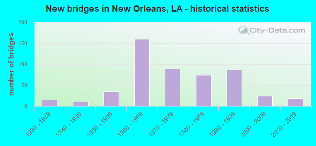
- New bridges - historical statistics
- 11910-1919
- 11920-1929
- 151930-1939
- 101940-1949
- 351950-1959
- 1601960-1969
- 901970-1979
- 741980-1989
- 871990-1999
- 242000-2009
- 192010-2019
- 12020-2022
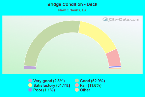
- Bridge Condition - Deck
- 2.3%Very good
- 52.9%Good
- 31.1%Satisfactory
- 11.6%Fair
- 1.1%Poor
- 1.1%Serious
- 0.8%Failed
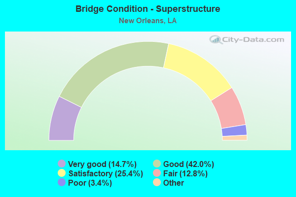
- Bridge Condition - Superstructure
- 14.7%Very good
- 42.0%Good
- 25.4%Satisfactory
- 12.8%Fair
- 3.4%Poor
- 1.7%Serious
- 0.2%Imminent failure
- 0.8%Failed
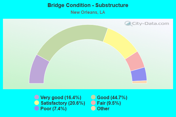
- Bridge Condition - Substructure
- 16.4%Very good
- 44.7%Good
- 20.6%Satisfactory
- 9.5%Fair
- 7.4%Poor
- 1.5%Serious
- 0.2%Imminent failure
- 0.8%Failed
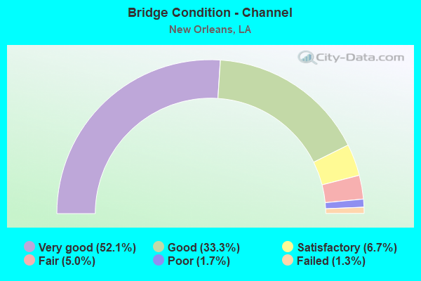
- Bridge Condition - Channel
- 52.1%Very good
- 33.3%Good
- 6.7%Satisfactory
- 5.0%Fair
- 1.7%Poor
- 1.3%Failed
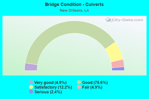
- Bridge Condition - Culverts
- 4.9%Very good
- 75.6%Good
- 12.2%Satisfactory
- 4.9%Fair
- 2.4%Serious
Find on map >> Show street view
Structure Number: 23602830801518, Location: 0.03 MI W OF BARONNE ST. (Lat: 29.944061, Lng: -90.075950), Route carried "under" structure: ServiceUS 90, Structure Length: 0. m, Average Daily Traffic: 8,760 (year 2016), Features Intersected: CALLIOPE ST(WB SERVICE R
Minimum Vertical Clearance: 30+ m (98+ ft), Kilometerpoint: 1.275, Lanes on structure: 1, Lanes under structure: 2, Length of Maximum Span: 0.0m
Find on map >> Show street view
Structure Number: 23602830801651, Location: 1.65 Mi South of I-10 (Lat: 29.941111, Lng: -90.071469), Route carried "under" structure: Ramp US 90, Structure Length: 0. m, Average Daily Traffic: 8,760 (year 2016), Features Intersected: US 90B EB on-ramp from U
Minimum Vertical Clearance: 5.61m (18.41ft), Kilometerpoint: 0.224, Lanes on structure: 2, Lanes under structure: 1, Length of Maximum Span: 0.0m
Find on map >> Show street view
Structure Number: 23602830801651, Location: 0.06 MI E of St Charles (Lat: 29.941461, Lng: -90.072439), Route carried "under" structure: ServiceUS 90, Structure Length: 0. m, Average Daily Traffic: 8,760 (year 2016), Features Intersected: US 90B EB Service Rd (Ca
Minimum Vertical Clearance: 5.49m (18.01ft), Kilometerpoint: 1.308, Lanes on structure: 3, Lanes under structure: 2, Length of Maximum Span: 0.0m
Find on map >> Show street view
Structure Number: 23602830801651, Location: 0.02 MI N of Calliope St (Lat: 29.940500, Lng: -90.070711), Route carried "under" structure: Ramp US 90, Structure Length: 0. m, Average Daily Traffic: 8,760 (year 2016), Features Intersected: US 90B EB Service Rd to
Minimum Vertical Clearance: 8.14m (26.71ft), Kilometerpoint: 0.047, Lanes on structure: 3, Lanes under structure: 1, Length of Maximum Span: 0.0m
Find on map >> Show street view
Structure Number: 23602830801651, Location: 0.40 MI SW of US 90 WB (Lat: 29.939231, Lng: -90.068081), Route carried "under" structure: Ramp US 90, Structure Length: 0. m, Average Daily Traffic: 8,760 (year 2016), Features Intersected: US 90B WB Off-Ramp to Tc
Minimum Vertical Clearance: 6.22m (20.41ft), Kilometerpoint: 0.579, Lanes on structure: 3, Lanes under structure: 1, Length of Maximum Span: 0.0m
Find on map >> Show street view
Structure Number: 23602830801651, Location: 0.2 MI W of C Center Blvd (Lat: 29.938969, Lng: -90.067619), Route carried "under" structure: Ramp US 90, Structure Length: 0. m, Average Daily Traffic: 8,760 (year 2016), Features Intersected: HOV Lane to Convention C
Minimum Vertical Clearance: 5.30m (17.39ft), Kilometerpoint: 0.447, Lanes on structure: 3, Lanes under structure: 1, Length of Maximum Span: 0.0m
Find on map >> Show street view
Structure Number: 23602830801651, Location: 0.03 MI E of Tchoup St (Lat: 29.938069, Lng: -90.066100), Route carried "under" structure: ServiceUS 90, Structure Length: 0. m, Average Daily Traffic: 8,760 (year 2016), Features Intersected: US 90B EB Service rd Cal
Minimum Vertical Clearance: 15.67m (51.41ft), Kilometerpoint: 2.047, Lanes on structure: 3, Lanes under structure: 2, Length of Maximum Span: 0.0m
Find on map >> Show street view
Structure Number: 23602830801651, Location: 0.01 MI S of Conn. Blvd (Lat: 29.937811, Lng: -90.064219), Route carried "under" structure: Ramp US 90, Structure Length: 0. m, Average Daily Traffic: 8,760 (year 2016), Features Intersected: Convention Center blvd o
Minimum Vertical Clearance: 20.45m (67.09ft), Kilometerpoint: 0.045, Lanes on structure: 3, Lanes under structure: 1, Length of Maximum Span: 0.0m
Find on map >> Show street view
Structure Number: 23602830801766, Location: 0.12 MI NE OF CAMP ST. (Lat: 29.940981, Lng: -90.070619), Route carried "under" structure: Ramp US 90, Structure Length: 0. m, Average Daily Traffic: 8,760 (year 2016), Features Intersected: US 90 EB SERVICE RD TO U
Minimum Vertical Clearance: 7.13m (23.39ft), Kilometerpoint: 0.101, Lanes on structure: 1, Lanes under structure: 1, Length of Maximum Span: 0.0m
Find on map >> Show street view
Structure Number: 23602830801767, Location: 0.08 MI S OF MAGIZINE ST (Lat: 29.940881, Lng: -90.071481), Route carried "under" structure: Ramp US 90, Structure Length: 0. m, Average Daily Traffic: 8,760 (year 2016), Features Intersected: US 90B EB ON RAMP FROM U
Minimum Vertical Clearance: 4.97m (16.31ft), Kilometerpoint: 0.249, Lanes on structure: 1, Lanes under structure: 1, Length of Maximum Span: 0.0m
Find on map >> Show street view
Structure Number: 23602830801767, Location: 0.07 MI E OF CAMP ST (Lat: 29.940319, Lng: -90.070889), Route carried "under" structure: Ramp US 90, Structure Length: 0. m, Average Daily Traffic: 8,760 (year 2016), Features Intersected: US 90B EB SERVICE RD. TO
Minimum Vertical Clearance: 9.91m (32.51ft), Kilometerpoint: 0.019, Lanes on structure: 1, Lanes under structure: 1, Length of Maximum Span: 0.0m
Find on map >> Show street view
Structure Number: 23602830801968, Location: 0.05 MI W OF MAGIZINE ST. (Lat: 29.941500, Lng: -90.071111), Route carried "under" structure: ServiceUS 90, Structure Length: 0. m, Average Daily Traffic: 8,760 (year 2016), Features Intersected: US 90B WB SERVICE RD(CAL
Minimum Vertical Clearance: 5.61m (18.41ft), Kilometerpoint: 0.721, Lanes on structure: 2, Lanes under structure: 2, Length of Maximum Span: 0.0m
Find on map >> Show street view
Structure Number: 23602830801968, Location: 0.03 MI W OF MAGAZINE ST (Lat: 29.941381, Lng: -90.070950), Route carried "under" structure: Ramp US 90, Structure Length: 0. m, Average Daily Traffic: 8,760 (year 2016), Features Intersected: US 90B WB SERVICE RD ON
Minimum Vertical Clearance: 7.56m (24.80ft), Kilometerpoint: 0.163, Lanes on structure: 2, Lanes under structure: 1, Length of Maximum Span: 0.0m
Find on map >> Show street view
Structure Number: 23602830801968, Location: 0.12 MI NE OF CAMP ST. (Lat: 29.941089, Lng: -90.070631), Route carried "under" structure: Ramp US 90, Structure Length: 0. m, Average Daily Traffic: 8,760 (year 2016), Features Intersected: US 90B EB RAMP TO US 90B
Minimum Vertical Clearance: 7.62m (25.00ft), Kilometerpoint: 0.113, Lanes on structure: 1, Lanes under structure: 1, Length of Maximum Span: 0.0m
Find on map >> Show street view
Structure Number: 23602830801973, Location: 2.39 MI W OF LA 428 (Lat: 29.939300, Lng: -90.068039), Route carried "under" structure: Ramp US 90, Structure Length: 0. m, Average Daily Traffic: 8,760 (year 2016), Features Intersected: US 90B WB OFF RAMP TO TC
Minimum Vertical Clearance: 5.61m (18.41ft), Kilometerpoint: 0.570, Lanes on structure: 1, Lanes under structure: 1, Length of Maximum Span: 0.0m
Find on map >> Show street view
Structure Number: 23602830801973, Location: 0.28 MI W OF CONV.CENTER (Lat: 29.939031, Lng: -90.067539), Route carried "under" structure: Ramp US 90, Structure Length: 0. m, Average Daily Traffic: 8,760 (year 2016), Features Intersected: HOV LANE OFF RAMP TO CON
Minimum Vertical Clearance: 7.96m (26.12ft), Kilometerpoint: 0.457, Lanes on structure: 1, Lanes under structure: 1, Length of Maximum Span: 0.0m
Find on map >> Show street view
Structure Number: 23602830802075, Location: 0.21 MI W of Conv. Blvd (Lat: 29.938781, Lng: -90.067769), Route carried "under" structure: Ramp US 90, Structure Length: 0. m, Average Daily Traffic: 8,760 (year 2016), Features Intersected: Hou Lane From Covention
Minimum Vertical Clearance: 7.62m (25.00ft), Kilometerpoint: 0.422, Lanes on structure: 1, Lanes under structure: 1, Length of Maximum Span: 0.0m
Find on map >> Show street view
Structure Number: 23602830802075, Location: .047 MI W of Miss. River (Lat: 29.939069, Lng: -90.068139), Route carried "under" structure: Ramp US 90, Structure Length: 0. m, Average Daily Traffic: 8,760 (year 2016), Features Intersected: US 90 WB Off-Ramp to Tch
Minimum Vertical Clearance: 8.47m (27.79ft), Kilometerpoint: 0.599, Lanes on structure: 1, Lanes under structure: 1, Length of Maximum Span: 0.0m
Find on map >> Show street view
Structure Number: 23602830802075, Location: 0.03 MI E of Gaiennie (Lat: 29.940400, Lng: -90.070769), Route carried "under" structure: Ramp US 90, Structure Length: 0. m, Average Daily Traffic: 8,760 (year 2016), Features Intersected: US 90B EB Service Rd Ram
Minimum Vertical Clearance: 4.63m (15.19ft), Kilometerpoint: 0.034, Lanes on structure: 1, Lanes under structure: 1, Length of Maximum Span: 0.0m
Find on map >> Show street view
Structure Number: 23602830802314, Location: .04 miles E of Annun. St. (Lat: 29.938681, Lng: -90.067861), Route carried "under" structure: ServiceUS 90, Structure Length: 0. m, Average Daily Traffic: 8,760 (year 2016), Features Intersected: US 90 Serv. Rd. under HO
Minimum Vertical Clearance: 9.85m (32.32ft), Kilometerpoint: 1.856, Lanes on structure: 2, Lanes under structure: 2, Length of Maximum Span: 0.0m
Find on map >> Show street view
Structure Number: 23602830802314, Location: .56 miles W of Miss. R. (Lat: 29.937919, Lng: -90.067261), Route carried "under" structure: Ramp US 90, Structure Length: 0. m, Average Daily Traffic: 8,760 (year 2016), Features Intersected: 90 WB off-ramp under HOV
Minimum Vertical Clearance: 5.79m (19.00ft), Kilometerpoint: 0.027, Lanes on structure: 2, Lanes under structure: 2, Length of Maximum Span: 0.0m
Find on map >> Show street view
Structure Number: 23602830802318, Location: 0.02 MI E of Annunciation (Lat: 29.938889, Lng: -90.068200), Route carried "under" structure: ServiceUS 90, Structure Length: 0. m, Average Daily Traffic: 8,760 (year 2016), Features Intersected: US 90B EB Service Rd und
Minimum Vertical Clearance: 6.95m (22.80ft), Kilometerpoint: 1.815, Lanes on structure: 1, Lanes under structure: 2, Length of Maximum Span: 0.0m
Find on map >> Show street view
Structure Number: 23602830802318, Location: 0.12 MI W of Tchoup St. (Lat: 29.939631, Lng: -90.067339), Route carried "under" structure: ServiceUS 90, Structure Length: 0. m, Average Daily Traffic: 8,760 (year 2016), Features Intersected: US 90B WB Service Rd und
Minimum Vertical Clearance: 13.26m (43.50ft), Kilometerpoint: 0.299, Lanes on structure: 1, Lanes under structure: 2, Length of Maximum Span: 0.0m
Find on map >> Show street view
Structure Number: 23602830802318, Location: 0.01 W of Tchoup St. (Lat: 29.939150, Lng: -90.065661), Route carried "under" structure: Ramp US 90, Structure Length: 0. m, Average Daily Traffic: 8,760 (year 2016), Features Intersected: US 90B WB Service Rd und
Minimum Vertical Clearance: 23.10m (75.79ft), Kilometerpoint: 0.315, Lanes on structure: 1, Lanes under structure: 2, Length of Maximum Span: 0.0m
Find on map >> Show street view
Structure Number: 23602830802325, Location: 0.08 MI E OF ANNUNCIATION (Lat: 29.938411, Lng: -90.067389), Route carried "under" structure: ServiceUS 90, Structure Length: 0. m, Average Daily Traffic: 8,760 (year 2016), Features Intersected: US 90B EB SERVICE RD UND
Minimum Vertical Clearance: 19.63m (64.40ft), Kilometerpoint: 1.910, Lanes on structure: 1, Lanes under structure: 2, Length of Maximum Span: 0.0m
Find on map >> Show street view
Structure Number: 23602830802325, Location: 2.43 MI W OF LA 428 (Lat: 29.938131, Lng: -90.067761), Route carried "under" structure: Ramp US 90, Structure Length: 0. m, Average Daily Traffic: 8,760 (year 2016), Features Intersected: US 90B WB OFF RAMP TO TC
Minimum Vertical Clearance: 12.89m (42.29ft), Kilometerpoint: 0.713, Lanes on structure: 1, Lanes under structure: 1, Length of Maximum Span: 0.0m
Find on map >> Show street view
Structure Number: 23602830802325, Location: 0.22 MI W OF CONV. CENTER (Lat: 29.938231, Lng: -90.067689), Route carried "under" structure: Ramp US 90, Structure Length: 0. m, Average Daily Traffic: 8,760 (year 2016), Features Intersected: HOV LANE FROM CONVENTION
Minimum Vertical Clearance: 5.85m (19.19ft), Kilometerpoint: 0.357, Lanes on structure: 1, Lanes under structure: 1, Length of Maximum Span: 0.0m
Find on map >> Show street view
Structure Number: 23602830802325, Location: 0.02 MI E OF TCHOUP. ST (Lat: 29.938039, Lng: -90.066331), Route carried "under" structure: ServiceUS 90, Structure Length: 0. m, Average Daily Traffic: 8,760 (year 2016), Features Intersected: US 90B EB SERVICE RD. UN
Minimum Vertical Clearance: 24.78m (81.30ft), Kilometerpoint: 2.023, Lanes on structure: 1, Lanes under structure: 2, Length of Maximum Span: 0.0m
Find on map >> Show street view
Structure Number: 23602830802325, Location: 0.03 MI SW OF CONV CENTER (Lat: 29.937639, Lng: -90.064369), Route carried "under" structure: Ramp US 90, Structure Length: 0. m, Average Daily Traffic: 8,760 (year 2016), Features Intersected: CONVENTION CENTER BLVD S
Minimum Vertical Clearance: 30+ m (98+ ft), Kilometerpoint: 0.021, Lanes on structure: 1, Lanes under structure: 1, Length of Maximum Span: 0.0m
Find on map >> Show street view
Structure Number: 23602830803011, Location: 0.5 MI N OF LA 23 (Lat: 29.937719, Lng: -90.050319), Route carried "under" structure: State highway 428, Structure Length: 0. m, Average Daily Traffic: 3,800 (year 2016), Features Intersected: LA 428 NB UNDER US 90B E
Minimum Vertical Clearance: 28.04m (91.99ft), Kilometerpoint: 0.127, Lanes on structure: 1, Length of Maximum Span: 0.0m
Find on map >> Show street view
Structure Number: 23602830803011, Location: 0.5 MI N OF LA 23 (Lat: 29.937869, Lng: -90.050511), Route carried "under" structure: State highway 428, Structure Length: 0. m, Average Daily Traffic: 3,800 (year 2016), Features Intersected: LA 428 SB UNDER US 90B E
Minimum Vertical Clearance: 29.11m (95.51ft), Kilometerpoint: 0.552, Lanes on structure: 1, Length of Maximum Span: 0.0m
Find on map >> Show street view
Structure Number: 23602830803012, Location: 0.6 MI N OF LA 23 (Lat: 29.938731, Lng: -90.050339), Route carried "under" structure: State highway 428, Structure Length: 0. m, Average Daily Traffic: 3,800 (year 2016), Features Intersected: LA 428 NB UNDER US 90B W
Minimum Vertical Clearance: 30+ m (98+ ft), Kilometerpoint: 0.249, Lanes on structure: 1, Length of Maximum Span: 0.0m
Find on map >> Show street view
Structure Number: 23602830803012, Location: 0.6 MI N OF LA 23 (Lat: 29.939011, Lng: -90.050581), Route carried "under" structure: State highway 428, Structure Length: 0. m, Average Daily Traffic: 3,800 (year 2016), Features Intersected: LA 428 SB UNDER US 90B W
Minimum Vertical Clearance: 30+ m (98+ ft), Kilometerpoint: 0.417, Lanes on structure: 1, Length of Maximum Span: 0.0m
Find on map >> Show street view
Structure Number: 23602830803594, Location: 0.1 MI N OF LA 428@US90 (Lat: 29.931031, Lng: -90.037989), Route carried "under" structure: ServiceUS 90, Structure Length: 0. m, Average Daily Traffic: 8,940 (year 2017), Features Intersected: US 90B HOV OVER ON RAMP
Minimum Vertical Clearance: 5.55m (18.21ft), Kilometerpoint: 0.055, Lanes on structure: 2, Lanes under structure: 1, Length of Maximum Span: 0.0m
Find on map >> Show street view
Structure Number: 23602830803594, Location: 0.7 MI E OF LA 23 (Lat: 29.930550, Lng: -90.037919), Route carried "under" structure: State highway 428, Structure Length: 0. m, Average Daily Traffic: 65,200 (year 2014), Features Intersected: LA 428 WB UNDER US 90B H
Minimum Vertical Clearance: 5.73m (18.80ft), Kilometerpoint: 4.109, Lanes on structure: 2, Length of Maximum Span: 0.0m
Find on map >> Show street view
Structure Number: 23602830803594, Location: 0.7 MI E OF LA 23 (Lat: 29.930439, Lng: -90.038050), Route carried "under" structure: State highway 428, Structure Length: 0. m, Average Daily Traffic: 65,200 (year 2014), Features Intersected: LA 428 EB UNDER US 90B H
Minimum Vertical Clearance: 5.27m (17.29ft), Kilometerpoint: 0.531, Lanes on structure: 2, Length of Maximum Span: 0.0m
Find on map >> Show street view
Structure Number: 23602830804107, Location: LA 428@US90 B INTERCHANGE (Lat: 29.929900, Lng: -90.036581), Route carried "under" structure: Ramp US 90, Structure Length: 0. m, Average Daily Traffic: 8,940 (year 2017), Features Intersected: US 90B EB ON RAMP FROM L
Minimum Vertical Clearance: 6.83m (22.41ft), Kilometerpoint: 0.369, Lanes on structure: 2, Lanes under structure: 1, Length of Maximum Span: 0.0m
Find on map >> Show street view
Structure Number: 23602830804107, Location: LA 428@US90 B INTERCHANGE (Lat: 29.929950, Lng: -90.036350), Route carried "under" structure: ServiceUS 90, Structure Length: 0. m, Average Daily Traffic: 8,940 (year 2017), Features Intersected: MARR AVE UNDER US90B WB
Minimum Vertical Clearance: 5.85m (19.19ft), Kilometerpoint: 0.058, Lanes on structure: 2, Lanes under structure: 1, Length of Maximum Span: 0.0m
Find on map >> Show street view
Structure Number: 23602830804107, Location: LA 428@US90 B INTERCHANGE (Lat: 29.929861, Lng: -90.036269), Route carried "under" structure: ServiceUS 90, Structure Length: 0. m, Average Daily Traffic: 8,940 (year 2017), Features Intersected: US 90B EB SERVICE RD UND
Minimum Vertical Clearance: 5.40m (17.72ft), Kilometerpoint: 0.068, Lanes on structure: 2, Lanes under structure: 2, Length of Maximum Span: 0.0m
Find on map >> Show street view
Structure Number: 23602830804107, Location: LA 428@US90 B INTERCHANGE (Lat: 29.931511, Lng: -90.038889), Route carried "under" structure: Ramp US 90, Structure Length: 0. m, Average Daily Traffic: 8,940 (year 0000), Features Intersected: LA 428 WB ON RAMP TO US
Minimum Vertical Clearance: 10.36m (33.99ft), Kilometerpoint: 0.193, Lanes on structure: 2, Lanes under structure: 1, Length of Maximum Span: 0.0m
Find on map >> Show street view
Structure Number: 23602830804107, Location: LA 428@US90 B INTERCHANGE (Lat: 29.930611, Lng: -90.038839), Route carried "under" structure: Ramp US 90, Structure Length: 0. m, Average Daily Traffic: 8,940 (year 2017), Features Intersected: US90 WB OFF RAMP TO HEND
Minimum Vertical Clearance: 5.76m (18.90ft), Kilometerpoint: 0.101, Lanes on structure: 1, Lanes under structure: 4, Length of Maximum Span: 0.0m
Find on map >> Show street view
Structure Number: 23602830804107, Location: LA 428@US90 B INTERCHANGE (Lat: 29.930350, Lng: -90.038719), Route carried "under" structure: Ramp US 90, Structure Length: 0. m, Average Daily Traffic: 8,940 (year 2017), Features Intersected: TERRY PKWY OFF RAMP FROM
Minimum Vertical Clearance: 6.10m (20.01ft), Kilometerpoint: 0.428, Lanes on structure: 2, Lanes under structure: 2, Length of Maximum Span: 0.0m
Find on map >> Show street view
Structure Number: 23602830804107, Location: LA 428@US90 B INTERCHANGE (Lat: 29.930211, Lng: -90.038639), Route carried "under" structure: Ramp US 90, Structure Length: 0. m, Average Daily Traffic: 8,940 (year 2017), Features Intersected: US90B WB HOV LANE UNDER
Minimum Vertical Clearance: 6.07m (19.91ft), Kilometerpoint: 0.304, Lanes on structure: 2, Lanes under structure: 1, Length of Maximum Span: 0.0m
Find on map >> Show street view
Structure Number: 23602830804107, Location: LA 428@US90 B INTERCHANGE (Lat: 29.929989, Lng: -90.038411), Route carried "under" structure: Business US 90, Structure Length: 0. m, Average Daily Traffic: 89,400 (year 2017), Features Intersected: US990B WB UNDER US90B OF
Minimum Vertical Clearance: 11.92m (39.11ft), Kilometerpoint: 6.862, Lanes on structure: 2, Lanes under structure: 3, Length of Maximum Span: 0.0m
Find on map >> Show street view
Structure Number: 23602830804107, Location: LA 428@US90 B INTERCHANGE (Lat: 29.929719, Lng: -90.038150), Route carried "under" structure: Business US 90, Structure Length: 0. m, Average Daily Traffic: 8,940 (year 2017), Features Intersected: US90B EB HOV LANE ON RAM
Minimum Vertical Clearance: 13.41m (44.00ft), Kilometerpoint: 0.504, Lanes on structure: 2, Lanes under structure: 2, Length of Maximum Span: 0.0m
Find on map >> Show street view
Structure Number: 23602830804107, Location: LA 428@US90 B INTERCHANGE (Lat: 29.929669, Lng: -90.037989), Route carried "under" structure: Ramp US 90, Structure Length: 0. m, Average Daily Traffic: 8,940 (year 2017), Features Intersected: us90b eb of ramp to us90
Minimum Vertical Clearance: 8.93m (29.30ft), Kilometerpoint: 0.026, Lanes on structure: 1, Lanes under structure: 4, Length of Maximum Span: 0.0m
Find on map >> Show street view
Structure Number: 23602830804107, Location: LA 428@US90 B INTERCHANGE (Lat: 29.929631, Lng: -90.037889), Route carried "under" structure: Business US 90, Structure Length: 0. m, Average Daily Traffic: 89,400 (year 2017), Features Intersected: US90B EB UNDER US90B WB
Minimum Vertical Clearance: 8.32m (27.30ft), Kilometerpoint: 0.389, Lanes on structure: 2, Lanes under structure: 3, Length of Maximum Span: 0.0m
Find on map >> Show street view
Structure Number: 23602830804107, Location: LA 428@US90 B INTERCHANGE (Lat: 29.929600, Lng: -90.037661), Route carried "under" structure: Ramp US 90, Structure Length: 0. m, Average Daily Traffic: 8,940 (year 2017), Features Intersected: US 90B EB SERVICE RD ON
Minimum Vertical Clearance: 8.08m (26.51ft), Kilometerpoint: 0.172, Lanes on structure: 2, Lanes under structure: 1, Length of Maximum Span: 0.0m
Find on map >> Show street view
Structure Number: 23602830804107, Location: LA 428@US90 B INTERCHANGE (Lat: 29.929600, Lng: -90.037550), Route carried "under" structure: Ramp US 90, Structure Length: 0. m, Average Daily Traffic: 8,940 (year 2017), Features Intersected: US 90 EB ON RAMP FROM LA
Minimum Vertical Clearance: 8.11m (26.61ft), Kilometerpoint: 0.203, Lanes on structure: 1, Length of Maximum Span: 0.0m
Find on map >> Show street view
Structure Number: 23602830804115, Location: LA 428@US90B INTERCHANGE (Lat: 29.931961, Lng: -90.038281), Route carried "under" structure: Business US 90, Structure Length: 0. m, Average Daily Traffic: 89,400 (year 2017), Features Intersected: US 90B UNDER US 90B HOV
Minimum Vertical Clearance: 6.86m (22.51ft), Kilometerpoint: 6.643, Lanes on structure: 1, Lanes under structure: 3, Length of Maximum Span: 0.0m
Find on map >> Show street view
Structure Number: 23602830804115, Location: LA 428@US 90B INTERCHANGE (Lat: 29.930469, Lng: -90.038650), Route carried "under" structure: State highway 428, Structure Length: 0. m, Average Daily Traffic: 65,200 (year 2014), Features Intersected: LA 428 EB UNDER US 90B H
Minimum Vertical Clearance: 13.17m (43.21ft), Kilometerpoint: 0.473, Lanes on structure: 1, Lanes under structure: 2, Length of Maximum Span: 0.0m
Find on map >> Show street view
Structure Number: 23602830804115, Location: LA 428@US 90B INTERCHANGE (Lat: 29.930581, Lng: -90.038550), Route carried "under" structure: State highway 428, Structure Length: 0. m, Average Daily Traffic: 65,200 (year 2014), Features Intersected: LA 428 WB UNDER US 90B H
Minimum Vertical Clearance: 13.72m (45.01ft), Kilometerpoint: 4.170, Lanes on structure: 2, Length of Maximum Span: 0.0m
Find on map >> Show street view
Structure Number: 23602830804115, Location: LA 428@US 90B INTERCHANGE (Lat: 29.931169, Lng: -90.038550), Route carried "under" structure: Ramp US 90, Structure Length: 0. m, Average Daily Traffic: 8,940 (year 2017), Features Intersected: LA 428 WB ON RAMP TO US
Minimum Vertical Clearance: 7.62m (25.00ft), Kilometerpoint: 0.246, Lanes on structure: 1, Length of Maximum Span: 0.0m
Find on map >> Show street view
Structure Number: 23602830804157, Location: LA 428@US90 B INTERCHANGE (Lat: 29.926389, Lng: -90.039489), Route carried "under" structure: Business US 90, Structure Length: 0. m, Average Daily Traffic: 89,400 (year 2017), Features Intersected: US 90B EB UNDER US90B WB
Minimum Vertical Clearance: 5.55m (18.21ft), Kilometerpoint: 15.667, Lanes on structure: 1, Lanes under structure: 3, Length of Maximum Span: 0.0m
Find on map >> Show street view
Structure Number: 23602830804157, Location: LA 428@US90 B INTERCHANGE (Lat: 29.927039, Lng: -90.039381), Route carried "under" structure: Business US 90, Structure Length: 0. m, Average Daily Traffic: 89,400 (year 2017), Features Intersected: US 90B WB UNDER US 90B W
Minimum Vertical Clearance: 5.73m (18.80ft), Kilometerpoint: 7.205, Lanes on structure: 1, Lanes under structure: 3, Length of Maximum Span: 0.0m
Find on map >> Show street view
Structure Number: 23602830804157, Location: LA 428@US90 B INTERCHANGE (Lat: 29.930481, Lng: -90.038769), Route carried "under" structure: State highway 428, Structure Length: 0. m, Average Daily Traffic: 65,200 (year 2014), Features Intersected: LA 428 EB UNDER US90B WB
Minimum Vertical Clearance: 11.43m (37.50ft), Kilometerpoint: 0.462, Lanes on structure: 2, Length of Maximum Span: 0.0m
Find on map >> Show street view
Structure Number: 23602830804157, Location: LA 428@US90 B INTERCHANGE (Lat: 29.930589, Lng: -90.038650), Route carried "under" structure: State highway 428, Structure Length: 0. m, Average Daily Traffic: 65,200 (year 2014), Features Intersected: LA 428 WB UNDER US90B OF
Minimum Vertical Clearance: 11.34m (37.20ft), Kilometerpoint: 4.179, Lanes on structure: 2, Lanes under structure: 2, Length of Maximum Span: 0.0m
Find on map >> Show street view
Structure Number: 23602830804157, Location: LA 428@US90 B INTERCHANGE (Lat: 29.931389, Lng: -90.038700), Route carried "under" structure: Ramp US 90, Structure Length: 0. m, Average Daily Traffic: 8,940 (year 2017), Features Intersected: LA 428 WB ON RAMP TO US9
Minimum Vertical Clearance: 4.97m (16.31ft), Kilometerpoint: 0.217, Lanes on structure: 2, Lanes under structure: 1, Length of Maximum Span: 0.0m
Find on map >> Show street view
Structure Number: 23602830804157, Location: LA 428@US90 B INTERCHANGE (Lat: 29.926050, Lng: -90.394439), Route carried "under" structure: ServiceUS 90, Structure Length: 0. m, Average Daily Traffic: 8,940 (year 2017), Features Intersected: US 90B EB SERVICE RD. UN
Minimum Vertical Clearance: 13.17m (43.21ft), Kilometerpoint: 4.965, Lanes on structure: 1, Lanes under structure: 3, Length of Maximum Span: 0.0m
Find on map >> Show street view
Structure Number: 23602830804172, Location: LA 428@US90B INTERCHANGE (Lat: 29.930519, Lng: -90.037369), Route carried "under" structure: State highway 428, Structure Length: 0. m, Average Daily Traffic: 65,200 (year 2014), Features Intersected: LA 428 WB UNDER US90B EB
Minimum Vertical Clearance: 5.33m (17.49ft), Kilometerpoint: 4.056, Lanes on structure: 2, Length of Maximum Span: 0.0m
Find on map >> Show street view
Structure Number: 23602830804172, Location: LA 428@US90B INTERCHANGE (Lat: 29.926619, Lng: -90.039250), Route carried "under" structure: Ramp US 90, Structure Length: 0. m, Average Daily Traffic: 8,940 (year 2017), Features Intersected: US 90B HOV ON RAMP FROM
Minimum Vertical Clearance: 6.13m (20.11ft), Kilometerpoint: 0.866, Lanes on structure: 1, Length of Maximum Span: 0.0m
Find on map >> Show street view
Structure Number: 23602830804172, Location: LA 428@US90B INTERCHANGE (Lat: 29.930419, Lng: -90.037750), Route carried "under" structure: State highway 428, Structure Length: 0. m, Average Daily Traffic: 65,200 (year 2014), Features Intersected: LA 428 EB UNDER US90B EB
Minimum Vertical Clearance: 5.64m (18.50ft), Kilometerpoint: 0.560, Lanes on structure: 2, Length of Maximum Span: 0.0m
Find on map >> Show street view
Structure Number: 23602830804201, Location: LA 428 @US90B INTERCHANGE (Lat: 29.930431, Lng: -90.038519), Route carried "under" structure: State highway 428, Structure Length: 0. m, Average Daily Traffic: 65,200 (year 2014), Features Intersected: LA 428 EB UNDER US 90B
Minimum Vertical Clearance: 5.64m (18.50ft), Kilometerpoint: 0.484, Lanes on structure: 3, Lanes under structure: 2, Length of Maximum Span: 0.0m
Find on map >> Show street view
Structure Number: 23602830804201, Location: LA 428 @US90B INTERCHANGE (Lat: 29.930569, Lng: -90.038311), Route carried "under" structure: State highway 428, Structure Length: 0. m, Average Daily Traffic: 65,200 (year 2014), Features Intersected: LA 428 WB UNDER US 90B W
Minimum Vertical Clearance: 5.18m (16.99ft), Kilometerpoint: 4.146, Lanes on structure: 2, Length of Maximum Span: 0.0m
Find on map >> Show street view
Structure Number: 23602830804201, Location: LA 428@US90B INTERCHANGE (Lat: 29.927081, Lng: -90.039250), Route carried "under" structure: Ramp US 90, Structure Length: 0. m, Average Daily Traffic: 8,940 (year 2017), Features Intersected: US 90B HOV LANE OFF RAMP
Minimum Vertical Clearance: 5.67m (18.60ft), Kilometerpoint: 0.068, Lanes on structure: 1, Length of Maximum Span: 0.0m
Find on map >> Show street view
Structure Number: 23602830804278, Location: LA 428@US 90B INTERCHANGE (Lat: 29.930539, Lng: -90.037819), Route carried "under" structure: State highway 428, Structure Length: 0. m, Average Daily Traffic: 65,200 (year 2014), Features Intersected: LA 428 WB UNDER US 90B H
Minimum Vertical Clearance: 6.40m (21.00ft), Kilometerpoint: 4.099, Lanes on structure: 2, Length of Maximum Span: 0.0m
Find on map >> Show street view
Structure Number: 23602830804278, Location: LA 428@US 90B INTERCHANGE (Lat: 29.930419, Lng: -90.037911), Route carried "under" structure: State highway 428, Structure Length: 0. m, Average Daily Traffic: 65,200 (year 2014), Features Intersected: LA 428 EB UNDER US 90B H
Minimum Vertical Clearance: 6.19m (20.31ft), Kilometerpoint: 0.544, Lanes on structure: 2, Length of Maximum Span: 0.0m
Find on map >> Show street view
Structure Number: 23602830804297, Location: LA 428@US90 B INTERCHANGE (Lat: 29.930600, Lng: -90.038789), Route carried "under" structure: State highway 428, Structure Length: 0. m, Average Daily Traffic: 65,200 (year 2014), Features Intersected: LA 428 WB UNDER US 90B O
Minimum Vertical Clearance: 10.61m (34.81ft), Kilometerpoint: 4.192, Lanes on structure: 2, Length of Maximum Span: 0.0m
Find on map >> Show street view
Structure Number: 23602830804297, Location: LA 428@US90 B INTERCHANGE (Lat: 29.930481, Lng: -90.038931), Route carried "under" structure: State highway 428, Structure Length: 0. m, Average Daily Traffic: 65,200 (year 2014), Features Intersected: LA 428 EB UNDER US 90B O
Minimum Vertical Clearance: 10.39m (34.09ft), Kilometerpoint: 0.446, Lanes on structure: 2, Length of Maximum Span: 0.0m
Find on map >> Show street view
Structure Number: 23602830804556, Location: 0.96 MI NE OF LA 23NB (Lat: 29.926769, Lng: -90.039000), Route carried "under" structure: ServiceUS 90, Structure Length: 0. m, Average Daily Traffic: 8,940 (year 2017), Features Intersected: US 90B SERVICE RD UNDER
Minimum Vertical Clearance: 5.76m (18.90ft), Kilometerpoint: 0.523, Lanes on structure: 2, Lanes under structure: 3, Length of Maximum Span: 0.0m
Find on map >> Show street view
Structure Number: 23604503400011, Location: 0.01 Mi East of I-10 (Lat: 29.995381, Lng: -90.120139), Route carried "under" structure: Interstate 10, Structure Length: 0. m, Average Daily Traffic: 219,900 (year 2016), Features Intersected: I-10 WB UNDER I-610 EB
Minimum Vertical Clearance: 5.64m (18.50ft), Kilometerpoint: 38.906, Lanes on structure: 3, Lanes under structure: 3, Length of Maximum Span: 0.0m
Find on map >> Show street view
Structure Number: 23604503400482, Location: 0.07 MI FROM I-610 (Lat: 29.995769, Lng: -90.115850), Route carried "under" structure: Ramp Interstate 610, Structure Length: 0. m, Average Daily Traffic: 9,880 (year 2014), Features Intersected: I-610 WB OFF RAMP UNDER
Minimum Vertical Clearance: 4.97m (16.31ft), Kilometerpoint: 0.116, Lanes on structure: 2, Lanes under structure: 1, Length of Maximum Span: 0.0m
Find on map >> Show street view
Structure Number: 23604503400482, Location: 0.6 MI FROM I-610 (Lat: 29.992069, Lng: -90.116381), Route carried "under" structure: Interstate 10, Structure Length: 0. m, Average Daily Traffic: 77,050 (year 2016), Features Intersected: I-10 EB UNDER PONCHATRAI
Minimum Vertical Clearance: 4.85m (15.91ft), Kilometerpoint: 1.065, Lanes on structure: 2, Lanes under structure: 3, Length of Maximum Span: 0.0m
Find on map >> Show street view
Structure Number: 23604503400482, Location: Pont. Exp. @ I-10 (Lat: 29.992369, Lng: -90.116500), Route carried "under" structure: Interstate 10, Structure Length: 0. m, Average Daily Traffic: 77,050 (year 2016), Features Intersected: I-10 WB UNDER PONCHATRAI
Minimum Vertical Clearance: 6.19m (20.31ft), Kilometerpoint: 38.412, Lanes on structure: 2, Lanes under structure: 3, Length of Maximum Span: 0.0m
Find on map >> Show street view
Structure Number: 23604503400482, Location: 0.2 MI E OF I-10 (Lat: 29.995319, Lng: -90.116061), Route carried "under" structure: Ramp Interstate 610, Structure Length: 0. m, Average Daily Traffic: 9,880 (year 2014), Features Intersected: I-610 EB ON RAMP FROM PO
Minimum Vertical Clearance: 5.12m (16.80ft), Kilometerpoint: 0.198, Lanes on structure: 2, Lanes under structure: 1, Length of Maximum Span: 0.0m
Find on map >> Show street view
Structure Number: 23604503400482, Location: 0.2 MI E OF I-10 (Lat: 29.995369, Lng: -90.116050), Route carried "under" structure: Interstate 610, Structure Length: 0. m, Average Daily Traffic: 9,880 (year 2014), Features Intersected: I-610 EB OFF RAMP UNDER
Minimum Vertical Clearance: 5.00m (16.40ft), Kilometerpoint: 0.414, Lanes on structure: 2, Lanes under structure: 1, Length of Maximum Span: 0.0m
Find on map >> Show street view
Structure Number: 23604503400482, Location: 0.47 MI E OF I-10 (Lat: 29.995500, Lng: -90.116039), Route carried "under" structure: Interstate 610, Structure Length: 0. m, Average Daily Traffic: 98,800 (year 2014), Features Intersected: I-610 EB UNDER PONCHATRA
Minimum Vertical Clearance: 4.85m (15.91ft), Kilometerpoint: 0.761, Lanes on structure: 2, Lanes under structure: 2, Length of Maximum Span: 0.0m
Find on map >> Show street view
Structure Number: 23604503400482, Location: I-610 @ Pontr. Exp (Lat: 29.995700, Lng: -90.115861), Route carried "under" structure: Interstate 10, Structure Length: 0. m, Average Daily Traffic: 98,800 (year 2014), Features Intersected: I-610 WB UNDER PONCHATRA
Minimum Vertical Clearance: 4.88m (16.01ft), Kilometerpoint: 6.573, Lanes on structure: 2, Lanes under structure: 2, Length of Maximum Span: 0.0m
Find on map >> Show street view
Structure Number: 23604503400491, Location: I-610 ON RAMP @ WEST END (Lat: 29.995400, Lng: -90.115719), Route carried "under" structure: Ramp Interstate 610, Structure Length: 0. m, Average Daily Traffic: 9,880 (year 2014), Features Intersected: I-610 EB ON RAMP UNDER W
Minimum Vertical Clearance: 4.97m (16.31ft), Kilometerpoint: 0.010, Lanes on structure: 2, Lanes under structure: 1, Length of Maximum Span: 0.0m
Find on map >> Show street view
Structure Number: 23604503400491, Location: I-610 OFF RAMP @ WEST END (Lat: 29.995781, Lng: -90.115589), Route carried "under" structure: Ramp Interstate 610, Structure Length: 0. m, Average Daily Traffic: 9,880 (year 2014), Features Intersected: I-610 WB OFF RAMP UNDER
Minimum Vertical Clearance: 4.88m (16.01ft), Kilometerpoint: 0.790, Lanes on structure: 2, Lanes under structure: 1, Length of Maximum Span: 0.0m
Find on map >> Show street view
Structure Number: 23604503400491, Location: I-610 @ WEST END (Lat: 29.995719, Lng: -90.115589), Route carried "under" structure: Interstate 610, Structure Length: 0. m, Average Daily Traffic: 98,800 (year 2014), Features Intersected: I-610 WB UNDER WEST END
Minimum Vertical Clearance: 5.00m (16.40ft), Kilometerpoint: 0.790, Lanes on structure: 2, Lanes under structure: 1, Length of Maximum Span: 0.0m
Find on map >> Show street view
Structure Number: 23604503400491, Location: I-610 @ WEST END (Lat: 29.995511, Lng: -90.115719), Route carried "under" structure: Interstate 610, Structure Length: 0. m, Average Daily Traffic: 98,800 (year 2014), Features Intersected: I-610 EB UNDER WEST END
Minimum Vertical Clearance: 4.97m (16.31ft), Kilometerpoint: 0.793, Lanes on structure: 2, Lanes under structure: 1, Length of Maximum Span: 0.0m
Find on map >> Show street view
Structure Number: 23604503400491, Location: I-610 OFF RAMP @ WEST END (Lat: 29.995369, Lng: -90.115719), Route carried "under" structure: Ramp Interstate 610, Structure Length: 0. m, Average Daily Traffic: 9,880 (year 2014), Features Intersected: I-610 EB OFF RAMP UNDER
Minimum Vertical Clearance: 5.03m (16.50ft), Kilometerpoint: 0.010, Lanes on structure: 2, Lanes under structure: 1, Length of Maximum Span: 0.0m
Find on map >> Show street view
Structure Number: 23604503402691, Location: UNDER I-610 (Lat: 29.991950, Lng: -90.049381), Route carried "under" structure: Interstate 10, Structure Length: 0. m, Average Daily Traffic: 50,050 (year 2014), Features Intersected: I-10 EB UNDER I-610
Minimum Vertical Clearance: 5.70m (18.70ft), Kilometerpoint: 3.367, Lanes on structure: 2, Lanes under structure: 3, Length of Maximum Span: 0.0m
Find on map >> Show street view
Structure Number: 23604503402691, Location: UNDER I-610 (Lat: 29.991061, Lng: -90.066889), Route carried "under" structure: US 90, Structure Length: 0. m, Average Daily Traffic: 3,250 (year 2014), Features Intersected: US 90 NEW ORLEANS ST UND
Minimum Vertical Clearance: 4.69m (15.39ft), Kilometerpoint: 2.517, Lanes on structure: 3, Lanes under structure: 2, Length of Maximum Span: 0.0m
Find on map >> Show street view
Structure Number: 23604503402691, Location: UNDER I-610 (Lat: 29.991961, Lng: -90.049600), Route carried "under" structure: Interstate 10, Structure Length: 0. m, Average Daily Traffic: 50,050 (year 2014), Features Intersected: I-10 WB UNDER I-610 EB
Minimum Vertical Clearance: 5.61m (18.41ft), Kilometerpoint: 27.309, Lanes on structure: 2, Lanes under structure: 3, Length of Maximum Span: 0.0m
Find on map >> Show street view
Structure Number: 23604503402691, Location: UNDER I-610 (Lat: 29.991161, Lng: -90.058450), Route carried "under" structure: State highway 3021, Structure Length: 0. m, Average Daily Traffic: 14,950 (year 2014), Features Intersected: LA 3021 ELYSIAN FIELDS N
Minimum Vertical Clearance: 5.12m (16.80ft), Kilometerpoint: 2.002, Lanes on structure: 3, Lanes under structure: 3, Length of Maximum Span: 0.0m
Find on map >> Show street view
Structure Number: 23604503402691, Location: UNDER I-610 (Lat: 29.991300, Lng: -90.058781), Route carried "under" structure: State highway 3021, Structure Length: 0. m, Average Daily Traffic: 14,950 (year 2014), Features Intersected: LA 3021 SB / ELYSIAN FIE
Minimum Vertical Clearance: 5.09m (16.70ft), Kilometerpoint: 0.924, Lanes on structure: 3, Lanes under structure: 4, Length of Maximum Span: 0.0m
Find on map >> Show street view
Structure Number: 23604503402691, Location: UNDER I-610 (Lat: 29.993011, Lng: -90.048161), Route carried "under" structure: Ramp Interstate 10, Structure Length: 0. m, Average Daily Traffic: 21,990 (year 2016), Features Intersected: I-10 EB ON RAMP FROM FRA
Minimum Vertical Clearance: 5.85m (19.19ft), Kilometerpoint: 0.132, Lanes on structure: 2, Lanes under structure: 1, Length of Maximum Span: 0.0m
Find on map >> Show street view
Structure Number: 23604503402691, Location: UNDER I-610 (Lat: 29.990669, Lng: -90.065661), Route carried "under" structure: US 90, Structure Length: 0. m, Average Daily Traffic: 3,250 (year 2014), Features Intersected: US 90 / ALLEN ST UNDER I
Minimum Vertical Clearance: 5.03m (16.50ft), Kilometerpoint: 12.291, Lanes on structure: 3, Lanes under structure: 2, Length of Maximum Span: 0.0m
Find on map >> Show street view
Structure Number: 23604503402691, Location: Under 610/ St. Bernard Av (Lat: 29.992719, Lng: -90.077789), Route carried "under" structure: US 10, Structure Length: 0. m, Average Daily Traffic: 50,050 (year 2014), Features Intersected: I-610 EB off ramp to St.
Minimum Vertical Clearance: 5.61m (18.41ft), Kilometerpoint: 4.479, Lanes on structure: 3, Lanes under structure: 4, Length of Maximum Span: 0.0m
Find on map >> Show street view
Structure Number: 23604503403112, Location: US 90 @ I-610 (Lat: 29.991050, Lng: -90.066869), Route carried "under" structure: US 90, Structure Length: 0. m, Average Daily Traffic: 3,250 (year 2014), Features Intersected: US 90 / NEW ORLEANS STRE
Minimum Vertical Clearance: 4.51m (14.80ft), Kilometerpoint: 2.490, Lanes on structure: 3, Lanes under structure: 2, Length of Maximum Span: 0.0m
Find on map >> Show street view
Structure Number: 23604503403112, Location: LA 3021 @ I-610 (Lat: 29.991389, Lng: -90.058469), Route carried "under" structure: State highway 3021, Structure Length: 0. m, Average Daily Traffic: 14,950 (year 2014), Features Intersected: LA 3021 / ELYSIAN FIELDS
Minimum Vertical Clearance: 5.06m (16.60ft), Kilometerpoint: 2.028, Lanes on structure: 3, Lanes under structure: 4, Length of Maximum Span: 0.0m
Find on map >> Show street view
Structure Number: 23604503403112, Location: LA 3021 @ I-610 (Lat: 29.991519, Lng: -90.058789), Route carried "under" structure: State highway 3021, Structure Length: 0. m, Average Daily Traffic: 14,950 (year 2014), Features Intersected: LA 3021 / ELYSIAN FIELDS
Minimum Vertical Clearance: 5.06m (16.60ft), Kilometerpoint: 2.042, Lanes on structure: 3, Lanes under structure: 4, Length of Maximum Span: 0.0m
Find on map >> Show street view
Structure Number: 23604503403112, Location: US 90 @ I-610 (Lat: 29.991089, Lng: -90.065700), Route carried "under" structure: US 90, Structure Length: 0. m, Average Daily Traffic: 3,250 (year 2014), Features Intersected: US 90 / ALLEN ST UNDER I
Minimum Vertical Clearance: 4.94m (16.21ft), Kilometerpoint: 12.336, Lanes on structure: 3, Lanes under structure: 2, Length of Maximum Span: 0.0m
Find on map >> Show street view
Structure Number: 23604504300241, Location: 0.2 MI. N. OF LA 47 (Lat: 30.017719, Lng: -89.939631), Route carried "under" structure: Interstate 510, Structure Length: 0. m, Average Daily Traffic: 14,600 (year 2014), Features Intersected: I-510 NB UNDER ALMONASTE
Minimum Vertical Clearance: 5.00m (16.40ft), Kilometerpoint: 5.156, Lanes on structure: 2, Lanes under structure: 2, Length of Maximum Span: 0.0m
Find on map >> Show street view
Structure Number: 23604504300241, Location: 0.2 MI. S. OF US 90 (Lat: 30.017611, Lng: -89.939381), Route carried "under" structure: Interstate 510, Structure Length: 0. m, Average Daily Traffic: 14,600 (year 2014), Features Intersected: I-10 NB UNDER ALMONASTER
Minimum Vertical Clearance: 5.06m (16.60ft), Kilometerpoint: 0.356, Lanes on structure: 2, Lanes under structure: 2, Length of Maximum Span: 0.0m
Find on map >> Show street view
Structure Number: 23604504300242, Location: 0.58 MI. S. OF US 90 (Lat: 30.017811, Lng: -89.939381), Route carried "under" structure: Interstate 510, Structure Length: 0. m, Average Daily Traffic: 14,600 (year 2014), Features Intersected: I-510 NB UNDER WB ALOMON
Minimum Vertical Clearance: 5.03m (16.50ft), Kilometerpoint: 0.377, Lanes on structure: 2, Lanes under structure: 2, Length of Maximum Span: 0.0m
Find on map >> Show street view
Structure Number: 23604504300242, Location: 0.21 MI. N. OF LA 47 (Lat: 30.017911, Lng: -89.939631), Route carried "under" structure: Interstate 510, Structure Length: 0. m, Average Daily Traffic: 14,600 (year 2014), Features Intersected: I-510 SB UNDER ALMONASTE
Minimum Vertical Clearance: 5.03m (16.50ft), Kilometerpoint: 5.137, Lanes on structure: 2, Lanes under structure: 2, Length of Maximum Span: 0.0m
Find on map >> Show street view
Structure Number: 23604504300552, Location: 4.5 MI. E. OF I-10 (Lat: 30.026819, Lng: -89.939661), Route carried "under" structure: US 90, Structure Length: 0. m, Average Daily Traffic: 6,200 (year 2014), Features Intersected: US 90 EB UNDER I510 SB
Minimum Vertical Clearance: 5.27m (17.29ft), Kilometerpoint: 10.855, Lanes on structure: 3, Lanes under structure: 2, Length of Maximum Span: 0.0m
Find on map >> Show street view
Structure Number: 23604504300552, Location: 6.0 MI. W. OF US 11 (Lat: 30.027019, Lng: -89.939500), Route carried "under" structure: US 90, Structure Length: 0. m, Average Daily Traffic: 6,200 (year 2014), Features Intersected: US 90 WB UNDER I-510 SB
Minimum Vertical Clearance: 5.12m (16.80ft), Kilometerpoint: 15.635, Lanes on structure: 3, Lanes under structure: 2, Length of Maximum Span: 0.0m
Find on map >> Show street view
Structure Number: 23604504300581, Location: 4.5 MI. E. OF I-10 (Lat: 30.026939, Lng: -89.939331), Route carried "under" structure: US 90, Structure Length: 0. m, Average Daily Traffic: 6,200 (year 2014), Features Intersected: US 90 EB
Minimum Vertical Clearance: 8.20m (26.90ft), Kilometerpoint: 10.890, Lanes on structure: 3, Lanes under structure: 2, Length of Maximum Span: 0.0m
Find on map >> Show street view
Structure Number: 23604504300581, Location: 6.0 MI. W. OF US 11 (Lat: 30.027131, Lng: -89.939161), Route carried "under" structure: US 90, Structure Length: 0. m, Average Daily Traffic: 6,200 (year 2014), Features Intersected: US 90 WB
Minimum Vertical Clearance: 5.15m (16.90ft), Kilometerpoint: 15.601, Lanes on structure: 3, Lanes under structure: 2, Length of Maximum Span: 0.0m
Find on map >> Show street view
Structure Number: 23604504301401, Location: I-510 UNDER DWYER RD (Lat: 30.033611, Lng: -89.939931), Route carried "under" structure: ServiceInterstate 510, Structure Length: 0. m, Average Daily Traffic: 1,960 (year 2016), Features Intersected: I-510 SB UNDER DWYER RD
Minimum Vertical Clearance: 30+ m (98+ ft), Kilometerpoint: 2.775, Lanes on structure: 2, Lanes under structure: 4, Length of Maximum Span: 0.0m
Find on map >> Show street view
Structure Number: 23604504301401, Location: I-510 UNDER DWYER RD (Lat: 30.033869, Lng: -89.939581), Route carried "under" structure: Interstate 510, Structure Length: 0. m, Average Daily Traffic: 19,600 (year 2016), Features Intersected: I-510 UNDER DWYER RD EB
Minimum Vertical Clearance: 5.21m (17.09ft), Kilometerpoint: 3.388, Lanes on structure: 2, Lanes under structure: 3, Length of Maximum Span: 0.0m
Find on map >> Show street view
Structure Number: 23604504301401, Location: I-510 UNDER DWYER RD (Lat: 30.033961, Lng: -89.938950), Route carried "under" structure: ServiceInterstate 510, Structure Length: 0. m, Average Daily Traffic: 1,960 (year 2016), Features Intersected: I-510 SERVICE RD/PARIS R
Minimum Vertical Clearance: 4.97m (16.31ft), Kilometerpoint: 0.961, Lanes on structure: 2, Lanes under structure: 2, Length of Maximum Span: 0.0m
Find on map >> Show street view
Structure Number: 23604504301401, Location: I-510 UNDER DWYRE RD (Lat: 30.036381, Lng: -89.939250), Route carried "under" structure: Interstate 510, Structure Length: 0. m, Average Daily Traffic: 19,600 (year 2016), Features Intersected: I-510 NB UNDER DWYER RD
Minimum Vertical Clearance: 5.27m (17.29ft), Kilometerpoint: 2.160, Lanes on structure: 2, Lanes under structure: 2, Length of Maximum Span: 0.0m
Find on map >> Show street view
Structure Number: 23604504301402, Location: I-510 UND DWYER RD (Lat: 30.034611, Lng: -89.937439), Route carried "under" structure: ServiceInterstate 510, Structure Length: 0. m, Average Daily Traffic: 1,960 (year 2016), Features Intersected: i-510 sb under dwyer rd
Minimum Vertical Clearance: 6.68m (21.92ft), Kilometerpoint: 2.747, Lanes on structure: 2, Lanes under structure: 4, Length of Maximum Span: 0.0m
Find on map >> Show street view
Structure Number: 23604504301402, Location: I-510 UND DWYER RD (Lat: 30.034031, Lng: -89.939561), Route carried "under" structure: Interstate 510, Structure Length: 0. m, Average Daily Traffic: 19,600 (year 2016), Features Intersected: I-510 SB UNDER DWYER RD
Minimum Vertical Clearance: 5.43m (17.81ft), Kilometerpoint: 3.347, Lanes on structure: 2, Lanes under structure: 3, Length of Maximum Span: 0.0m
Find on map >> Show street view
Structure Number: 23604504301402, Location: I-510 UND DWYER RD (Lat: 30.303400, Lng: -89.939961), Route carried "under" structure: Interstate 510, Structure Length: 0. m, Average Daily Traffic: 19,600 (year 2016), Features Intersected: I-510 NB UNDER DWYER RD
Minimum Vertical Clearance: 5.36m (17.59ft), Kilometerpoint: 2.176, Lanes on structure: 2, Lanes under structure: 3, Length of Maximum Span: 0.0m
Find on map >> Show street view
Structure Number: 23604504301402, Location: I-510 UND DWYER RD (Lat: 30.034111, Lng: -89.938950), Route carried "under" structure: ServiceInterstate 510, Structure Length: 0. m, Average Daily Traffic: 1,960 (year 2016), Features Intersected: I-510 NB UND DWYER RD EB
Minimum Vertical Clearance: 4.82m (15.81ft), Kilometerpoint: 0.977, Lanes on structure: 2, Lanes under structure: 2, Length of Maximum Span: 0.0m
Find on map >> Show street view
Structure Number: 23604504305341, Location: 6.45 MI E OF US 90 (Lat: 30.059789, Lng: -89.939289), Route carried "under" structure: Interstate 10, Structure Length: 0. m, Average Daily Traffic: 33,050 (year 2014), Features Intersected: I-10 EB
Minimum Vertical Clearance: 5.03m (16.50ft), Kilometerpoint: 26.361, Lanes on structure: 2, Lanes under structure: 3, Length of Maximum Span: 0.0m
Find on map >> Show street view
Structure Number: 23604504305341, Location: 6.45 MI. E. OF US 90 (Lat: 30.059789, Lng: -89.939289), Route carried "under" structure: Interstate 10, Structure Length: 0. m, Average Daily Traffic: 33,050 (year 2014), Features Intersected: I-10 EB
Minimum Vertical Clearance: 5.03m (16.50ft), Kilometerpoint: 26.361, Lanes on structure: 2, Lanes under structure: 3, Length of Maximum Span: 0.0m
Find on map >> Show street view
Structure Number: 23604504305342, Location: 6.4 MI. E. OF US 90 (Lat: 30.059661, Lng: -89.939519), Route carried "under" structure: Interstate 10, Structure Length: 0. m, Average Daily Traffic: 33,050 (year 2014), Features Intersected: I-10 EB
Minimum Vertical Clearance: 5.12m (16.80ft), Kilometerpoint: 26.335, Lanes on structure: 2, Lanes under structure: 3, Length of Maximum Span: 0.0m
Find on map >> Show street view
Structure Number: 23604504305342, Location: 7.6 MI. W. OF US 11 (Lat: 30.060031, Lng: -89.939389), Route carried "under" structure: Interstate 10, Structure Length: 0. m, Average Daily Traffic: 33,050 (year 2014), Features Intersected: I-10 WB
Minimum Vertical Clearance: 5.12m (16.80ft), Kilometerpoint: 13.195, Lanes on structure: 2, Lanes under structure: 3, Length of Maximum Span: 0.0m
Find on map >> Show street view
Structure Number: 23604509001161, Location: 1.1 mile east of I10 (Lat: 29.982181, Lng: -90.114419), Route carried "under" structure: ServiceInterstate 10, Structure Length: 0. m, Average Daily Traffic: 770 (year 2016), Features Intersected: I10 over eastbound servi
Minimum Vertical Clearance: 4.54m (14.90ft), Kilometerpoint: 1.873, Lanes on structure: 3, Lanes under structure: 2, Length of Maximum Span: 0.0m