Bridge Statistics for New Orleans, Louisiana (LA)
Condition, Traffic, Stress, Structural Evaluation, Project Costs
- National Bridge Inventory (NBI) Statistics
- 840Number of bridges
- 69,872ft / 21,297mTotal length
- $922,208,000Total costs
- 18,135,528Total average daily traffic
- 2,072,962Total average daily truck traffic
- National Bridge Inventory (NBI) Registered Bridges for New Orleans
- No street view available for this location
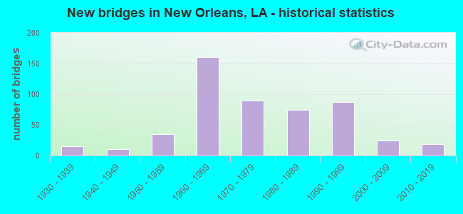
- New bridges - historical statistics
- 11910-1919
- 11920-1929
- 151930-1939
- 101940-1949
- 351950-1959
- 1601960-1969
- 901970-1979
- 741980-1989
- 871990-1999
- 242000-2009
- 192010-2019
- 12020-2022
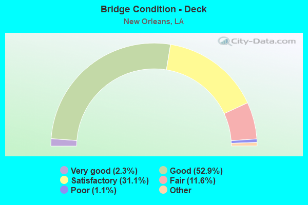
- Bridge Condition - Deck
- 2.3%Very good
- 52.9%Good
- 31.1%Satisfactory
- 11.6%Fair
- 1.1%Poor
- 1.1%Serious
- 0.8%Failed
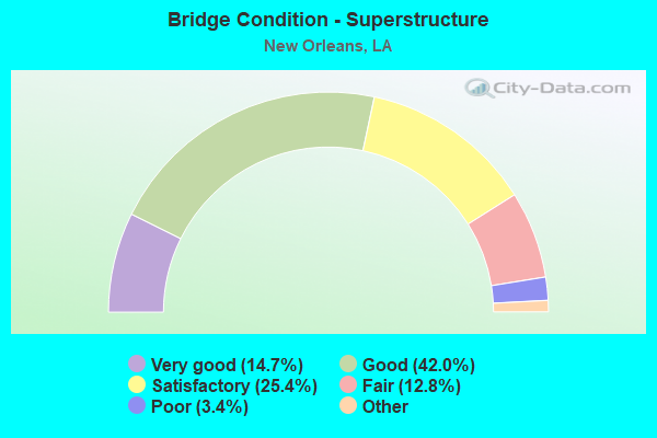
- Bridge Condition - Superstructure
- 14.7%Very good
- 42.0%Good
- 25.4%Satisfactory
- 12.8%Fair
- 3.4%Poor
- 1.7%Serious
- 0.2%Imminent failure
- 0.8%Failed
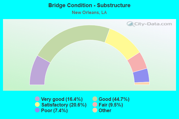
- Bridge Condition - Substructure
- 16.4%Very good
- 44.7%Good
- 20.6%Satisfactory
- 9.5%Fair
- 7.4%Poor
- 1.5%Serious
- 0.2%Imminent failure
- 0.8%Failed
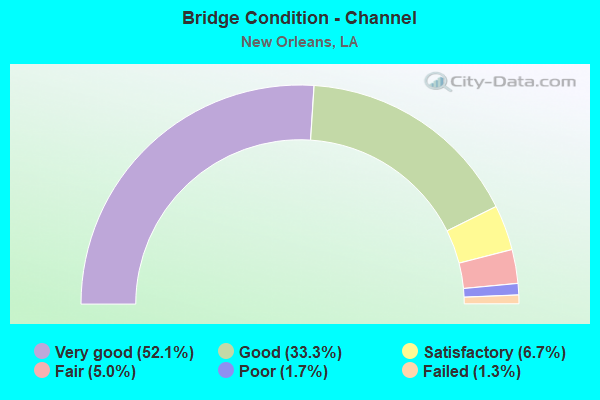
- Bridge Condition - Channel
- 52.1%Very good
- 33.3%Good
- 6.7%Satisfactory
- 5.0%Fair
- 1.7%Poor
- 1.3%Failed
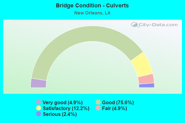
- Bridge Condition - Culverts
- 4.9%Very good
- 75.6%Good
- 12.2%Satisfactory
- 4.9%Fair
- 2.4%Serious
Find on map >> Show street view
Structure Number: 23630019900441, Location: 0.8 MI W OF ELYSIAN F. (Lat: 30.031161, Lng: -90.074519), Route carried "on" structure: City street , Year Built: 2003, Status: Open, Structure Length: 5.18m (16.99ft), Design Load: HS 20, Features Intersected: LONDON AVE. CANAL, Facility Carried by Structure: LAKESHORE DR
Minimum Vertical Clearance: 30+ m (98+ ft), Kilometerpoint: 0.000, Lanes on structure: 4, Owner: Local Agency, Approaching Roadway Width: 7.6m (24.9ft), Skew: 30 degrees, Material/Design: Concrete, Design/Construction: Slab, Number Of Spans In Main Unit: 4, Length of Maximum Span: 11.9m (39.0ft), Curb or Sidewalk Widths: Left: 1.6m (5.2ft), Right: 1.6m (5.2ft), Curb-To-Curb Width: 15.5m (50.9ft), Out-to-Out Width: 18.7m (61.4ft)
Condition: Deck: Good, Superstructure: Good, Substructure: Good, Channel: Good, Operating Rating: 52.8 metric tons, Method Used To Determine Operating Rating: Load and Resistance Factor Rating (LRFR) rating reported by rating factor(RF) method using HL-93 loadings, Inventory Rating: 40.8 metric tons, Method Used To Determine Inventory Rating: Load and Resistance Factor Rating (LRFR) rating reported by rating factor(RF) method using HL-93 loadings, Structural Evaluation: Better than present minimum criteria, Deck Geometry: Meets minimum limits, Waterway Adequacy: Equal to present desirable criteria, Approach Roadway Alignment: Equal to present desirable criteria, Designated Inspection Frequency: Every 24 months, Underwater Inspection Frequency: Every 60 months, Inspection Date: May 2021, Underwater Inspection Date: Febuary 2019, Deck Structure Type: Concrete Cast-file-Place
Find on map >> Show street view
Structure Number: 23630020900021, Location: 1.0 MI.W OF EDWARD S (Lat: 30.032800, Lng: -90.003461), Route carried "on" structure: County highway , Year Built: 1960, Status: Open, Structure Length: 2.90m (9.51ft), Design Load: HS 20, Features Intersected: LAWRENCE CANAL, Facility Carried by Structure: Morrison Rd
Minimum Vertical Clearance: 30+ m (98+ ft), Kilometerpoint: 0.000, Lanes on structure: 2, Owner: City or Municipal Highway Agency, Approaching Roadway Width: 9.8m (32.2ft), Material/Design: Concrete, Design/Construction: Slab, Number Of Spans In Main Unit: 5, Length of Maximum Span: 5.8m (19.0ft), Curb or Sidewalk Widths: Left: 0.0m, Right: 1.7m (5.6ft), Curb-To-Curb Width: 9.9m (32.5ft), Out-to-Out Width: 12.0m (39.4ft)
Condition: Deck: Satisfactory, Superstructure: Satisfactory, Substructure: Satisfactory, Channel: Very good, Operating Rating: 24.9 metric tons, Method Used To Determine Operating Rating: Load and Resistance Factor Rating (LRFR) rating reported by rating factor(RF) method using HL-93 loadings, Inventory Rating: 19.1 metric tons, Method Used To Determine Inventory Rating: Load and Resistance Factor Rating (LRFR) rating reported by rating factor(RF) method using HL-93 loadings, Structural Evaluation: Somewhat better than minimum adequacy, Deck Geometry: Meets minimum limits, Waterway Adequacy: Equal to present desirable criteria, Approach Roadway Alignment: Equal to present desirable criteria, Designated Inspection Frequency: Every 24 months, Inspection Date: Febuary 2021, Deck Structure Type: Concrete Precast Panels, Wearing Surface/Protective System: Wearing Surface: Monolithic Concrete
Find on map >> Show street view
Structure Number: 23630020900161, Location: 1.1 MI E OF PRESS DR (Lat: 30.033139, Lng: -90.028561), Route carried "on" structure: City street , Year Built: 1998, Status: Open, Structure Length: 65.78m (215.81ft), Design Load: HS 20, Features Intersected: CITY STREET, Facility Carried by Structure: CASINO BLVD
Minimum Vertical Clearance: 30+ m (98+ ft), Kilometerpoint: 0.000, Lanes on structure: 2, Lanes under structure: 3, Owner: Local Agency, Approaching Roadway Width: 7.3m (24.0ft), Material/Design: Prestressed concrete, Design/Construction: Stringer/Multi-beam, Number Of Spans In Main Unit: 25, Number Of Approach Spans: 12, Length of Maximum Span: 25.0m (82.0ft), Curb-To-Curb Width: 12.2m (40.0ft), Out-to-Out Width: 13.2m (43.3ft)
Condition: Deck: Good, Superstructure: Very good, Substructure: Good, Operating Rating: 34.7 metric tons, Method Used To Determine Operating Rating: Load and Resistance Factor Rating (LRFR) rating reported by rating factor(RF) method using HL-93 loadings, Inventory Rating: 26.6 metric tons, Method Used To Determine Inventory Rating: Load and Resistance Factor Rating (LRFR) rating reported by rating factor(RF) method using HL-93 loadings, Structural Evaluation: Equal to present minimum criteria, Deck Geometry: Better than present minimum criteria, Underclear: Meets minimum limits, Approach Roadway Alignment: Equal to present desirable criteria, Designated Inspection Frequency: Every 24 months, Inspection Date: May 2021, Deck Structure Type: Other, Wearing Surface/Protective System: Wearing Surface: Monolithic Concrete
Find on map >> Show street view
Structure Number: 23630020900167, Location: 1.2 MI E OF PREES DR (Lat: 30.033789, Lng: -90.025731), Route carried "on" structure: Ramp City street , Year Built: 1998, Status: Open, Structure Length: 38.13m (125.10ft), Design Load: HS 20, Features Intersected: CITY STREET/RAILROAD, Facility Carried by Structure: CASINO BLVD/OFF-RA
Minimum Vertical Clearance: 30+ m (98+ ft), Kilometerpoint: 0.000, Lanes on structure: 1, Lanes under structure: 1, Owner: Local Agency, Approaching Roadway Width: 7.6m (24.9ft), Material/Design: Prestressed concrete, Design/Construction: Stringer/Multi-beam, Number Of Spans In Main Unit: 14, Number Of Approach Spans: 7, Length of Maximum Span: 25.9m (85.0ft), Curb-To-Curb Width: 7.6m (24.9ft), Out-to-Out Width: 8.6m (28.2ft)
Condition: Deck: Good, Superstructure: Very good, Substructure: Good, Operating Rating: 36.0 metric tons, Method Used To Determine Operating Rating: Load and Resistance Factor Rating (LRFR) rating reported by rating factor(RF) method using HL-93 loadings, Inventory Rating: 27.9 metric tons, Method Used To Determine Inventory Rating: Load and Resistance Factor Rating (LRFR) rating reported by rating factor(RF) method using HL-93 loadings, Structural Evaluation: Better than present minimum criteria, Deck Geometry: Better than present minimum criteria, Underclear: Equal to present desirable criteria, Approach Roadway Alignment: Equal to present desirable criteria, Designated Inspection Frequency: Every 24 months, Inspection Date: May 2021, Deck Structure Type: Other, Wearing Surface/Protective System: Wearing Surface: Monolithic Concrete
Find on map >> Show street view
Structure Number: 23630021895981, Location: 0.75 MI SE OF LA 47 (Lat: 30.035561, Lng: -89.996539), Route carried "on" structure: County highway , Year Built: 1975, Status: Posted for load, Structure Length: 1.49m (4.89ft), Design Load: HS 20, Features Intersected: DRAINAGE CANAL, Facility Carried by Structure: Crowder BLVD
Minimum Vertical Clearance: 30+ m (98+ ft), Kilometerpoint: 0.000, Lanes on structure: 2, Owner: City or Municipal Highway Agency, Approaching Roadway Width: 13.4m (44.0ft), Skew: 10 degrees, Material/Design: Concrete, Design/Construction: Slab, Number Of Spans In Main Unit: 3, Length of Maximum Span: 7.3m (24.0ft), Curb or Sidewalk Widths: Left: 0.0m, Right: 1.7m (5.6ft), Curb-To-Curb Width: 13.5m (44.3ft), Out-to-Out Width: 16.0m (52.5ft)
Condition: Deck: Good, Superstructure: Good, Substructure: Fair, Channel: Very good, Operating Rating: 26.2 metric tons, Method Used To Determine Operating Rating: Load and Resistance Factor Rating (LRFR) rating reported by rating factor(RF) method using HL-93 loadings, Inventory Rating: 20.4 metric tons, Method Used To Determine Inventory Rating: Load and Resistance Factor Rating (LRFR) rating reported by rating factor(RF) method using HL-93 loadings, Structural Evaluation: Somewhat better than minimum adequacy, Deck Geometry: Superior to present desirable criteria, Waterway Adequacy: Equal to present desirable criteria, Approach Roadway Alignment: Equal to present desirable criteria, Bridge Posting: Required (Relationship of Operating Rating to Maximum Legal Load: 0.1 - 9.9% below), Designated Inspection Frequency: Every 24 months, Inspection Date: Febuary 2021, Deck Structure Type: Concrete Cast-file-Place, Wearing Surface/Protective System: Wearing Surface: Monolithic Concrete
Find on map >> Show street view
Structure Number: 23630021895982, Location: 0.75 MI SE OF LA 47 (Lat: 30.035600, Lng: -89.996881), Route carried "on" structure: County highway , Year Built: 1975, Status: Posted for load, Structure Length: 1.49m (4.89ft), Design Load: HS 20, Features Intersected: DRAINAGE CANAL, Facility Carried by Structure: Crowder BLVD
Minimum Vertical Clearance: 30+ m (98+ ft), Kilometerpoint: 0.000, Lanes on structure: 2, Owner: City or Municipal Highway Agency, Approaching Roadway Width: 13.4m (44.0ft), Skew: 10 degrees, Material/Design: Concrete, Design/Construction: Slab, Number Of Spans In Main Unit: 3, Length of Maximum Span: 7.3m (24.0ft), Curb or Sidewalk Widths: Left: 1.7m (5.6ft), Right: 0.0m, Curb-To-Curb Width: 13.6m (44.6ft), Out-to-Out Width: 16.0m (52.5ft)
Condition: Deck: Good, Superstructure: Good, Substructure: Fair, Channel: Very good, Operating Rating: 26.2 metric tons, Method Used To Determine Operating Rating: Load and Resistance Factor Rating (LRFR) rating reported by rating factor(RF) method using HL-93 loadings, Inventory Rating: 20.4 metric tons, Method Used To Determine Inventory Rating: Load and Resistance Factor Rating (LRFR) rating reported by rating factor(RF) method using HL-93 loadings, Structural Evaluation: Somewhat better than minimum adequacy, Deck Geometry: Superior to present desirable criteria, Waterway Adequacy: Equal to present desirable criteria, Approach Roadway Alignment: Equal to present desirable criteria, Bridge Posting: Required (Relationship of Operating Rating to Maximum Legal Load: 0.1 - 9.9% below), Designated Inspection Frequency: Every 24 months, Inspection Date: Febuary 2021, Deck Structure Type: Concrete Cast-file-Place, Wearing Surface/Protective System: Wearing Surface: Monolithic Concrete
Find on map >> Show street view
Structure Number: 23630021900061, Location: U3630021900061 (Lat: 30.038950, Lng: -90.008619), Route carried "on" structure: City street , Year Built: 1998, Status: Open, Structure Length: 60.59m (198.79ft), Design Load: HS 20, Features Intersected: CITY STREET/RAILROAD, Facility Carried by Structure: STAR & STRIPES BLV
Minimum Vertical Clearance: 30+ m (98+ ft), Kilometerpoint: 0.000, Lanes on structure: 2, Lanes under structure: 2, Owner: Local Agency, Approaching Roadway Width: 7.3m (24.0ft), Material/Design: Prestressed concrete, Design/Construction: Stringer/Multi-beam, Number Of Spans In Main Unit: 23, Number Of Approach Spans: 6, Length of Maximum Span: 23.2m (76.1ft), Curb-To-Curb Width: 12.2m (40.0ft), Out-to-Out Width: 13.1m (43.0ft)
Condition: Deck: Good, Superstructure: Good, Substructure: Good, Operating Rating: 30.5 metric tons, Method Used To Determine Operating Rating: Load and Resistance Factor Rating (LRFR) rating reported by rating factor(RF) method using HL-93 loadings, Inventory Rating: 23.7 metric tons, Method Used To Determine Inventory Rating: Load and Resistance Factor Rating (LRFR) rating reported by rating factor(RF) method using HL-93 loadings, Structural Evaluation: Equal to present minimum criteria, Deck Geometry: Better than present minimum criteria, Underclear: Equal to present desirable criteria, Approach Roadway Alignment: Equal to present desirable criteria, Designated Inspection Frequency: Every 24 months, Inspection Date: May 2021, Deck Structure Type: Other, Wearing Surface/Protective System: Wearing Surface: Monolithic Concrete
Find on map >> Show street view
Structure Number: 23630022895961, Location: 0.75 MI SE OF LA 47 (Lat: 30.037131, Lng: -89.992631), Route carried "on" structure: County highway , Year Built: 1975, Status: Open, Structure Length: 2.32m (7.61ft), Design Load: HS 20, Features Intersected: DRAINAGE CANAL, Facility Carried by Structure: Morrison Rd
Minimum Vertical Clearance: 30+ m (98+ ft), Kilometerpoint: 0.000, Lanes on structure: 2, Owner: City or Municipal Highway Agency, Approaching Roadway Width: 9.8m (32.2ft), Material/Design: Concrete, Design/Construction: Slab, Number Of Spans In Main Unit: 4, Length of Maximum Span: 5.8m (19.0ft), Curb or Sidewalk Widths: Left: 0.0m, Right: 1.7m (5.6ft), Curb-To-Curb Width: 9.9m (32.5ft), Out-to-Out Width: 12.3m (40.4ft)
Condition: Deck: Satisfactory, Superstructure: Satisfactory, Substructure: Fair, Channel: Very good, Operating Rating: 25.9 metric tons, Method Used To Determine Operating Rating: Load and Resistance Factor Rating (LRFR) rating reported by rating factor(RF) method using HL-93 loadings, Inventory Rating: 20.1 metric tons, Method Used To Determine Inventory Rating: Load and Resistance Factor Rating (LRFR) rating reported by rating factor(RF) method using HL-93 loadings, Structural Evaluation: Somewhat better than minimum adequacy, Deck Geometry: Meets minimum limits, Waterway Adequacy: Equal to present desirable criteria, Approach Roadway Alignment: Equal to present desirable criteria, Designated Inspection Frequency: Every 24 months, Inspection Date: Febuary 2021, Deck Structure Type: Concrete Cast-file-Place, Wearing Surface/Protective System: Wearing Surface: Monolithic Concrete
Find on map >> Show street view
Structure Number: 23630023895471, Location: .2 MI. N. OF HWY. 90 (Lat: 30.037939, Lng: -89.912100), Route carried "on" structure: County highway , Year Built: 1970, Status: Open, Structure Length: 2.90m (9.51ft), Design Load: HS 20, Features Intersected: CANAL, Facility Carried by Structure: Aicee Fortier BLVD
Minimum Vertical Clearance: 30+ m (98+ ft), Kilometerpoint: 0.000, Lanes on structure: 4, Owner: City or Municipal Highway Agency, Approaching Roadway Width: 24.4m (80.1ft), Skew: 10 degrees, Material/Design: Concrete, Design/Construction: Slab, Number Of Spans In Main Unit: 5, Length of Maximum Span: 5.8m (19.0ft), Curb or Sidewalk Widths: Left: 1.2m (3.9ft), Right: 1.2m (3.9ft), Curb-To-Curb Width: 17.3m (56.8ft), Out-to-Out Width: 26.9m (88.3ft)
Condition: Deck: Fair, Superstructure: Fair, Substructure: Satisfactory, Channel: Satisfactory, Operating Rating: 28.5 metric tons, Method Used To Determine Operating Rating: Load and Resistance Factor Rating (LRFR) rating reported by rating factor(RF) method using HL-93 loadings, Inventory Rating: 22.0 metric tons, Method Used To Determine Inventory Rating: Load and Resistance Factor Rating (LRFR) rating reported by rating factor(RF) method using HL-93 loadings, Structural Evaluation: Somewhat better than minimum adequacy, Deck Geometry: Somewhat better than minimum adequacy, Waterway Adequacy: Equal to present desirable criteria, Approach Roadway Alignment: Equal to present desirable criteria, Designated Inspection Frequency: Every 24 months, Inspection Date: Febuary 2021, Deck Structure Type: Concrete Cast-file-Place, Wearing Surface/Protective System: Wearing Surface: Bituminous
Find on map >> Show street view
Structure Number: 23630023895941, Location: 0.6 MI SE OF LA 47 (Lat: 30.039189, Lng: -89.988139), Route carried "on" structure: County highway , Year Built: 1975, Status: Posted for load, Structure Length: 1.49m (4.89ft), Design Load: HS 20, Features Intersected: DRAINAGE CANAL, Facility Carried by Structure: Bundy Rd
Minimum Vertical Clearance: 30+ m (98+ ft), Kilometerpoint: 0.000, Lanes on structure: 2, Owner: City or Municipal Highway Agency, Approaching Roadway Width: 10.1m (33.1ft), Skew: 10 degrees, Material/Design: Concrete, Design/Construction: Slab, Number Of Spans In Main Unit: 3, Length of Maximum Span: 5.8m (19.0ft), Curb or Sidewalk Widths: Left: 0.0m, Right: 1.6m (5.2ft), Curb-To-Curb Width: 9.9m (32.5ft), Out-to-Out Width: 12.4m (40.7ft)
Condition: Deck: Good, Superstructure: Good, Substructure: Satisfactory, Channel: Very good, Operating Rating: 24.6 metric tons, Method Used To Determine Operating Rating: Load and Resistance Factor Rating (LRFR) rating reported by rating factor(RF) method using HL-93 loadings, Inventory Rating: 19.1 metric tons, Method Used To Determine Inventory Rating: Load and Resistance Factor Rating (LRFR) rating reported by rating factor(RF) method using HL-93 loadings, Structural Evaluation: Somewhat better than minimum adequacy, Deck Geometry: Meets minimum limits, Waterway Adequacy: Equal to present desirable criteria, Approach Roadway Alignment: Equal to present desirable criteria, Bridge Posting: Required (Relationship of Operating Rating to Maximum Legal Load: 10.0 - 19.9% below), Designated Inspection Frequency: Every 24 months, Inspection Date: Febuary 2021, Deck Structure Type: Concrete Precast Panels, Wearing Surface/Protective System: Wearing Surface: Monolithic Concrete
Find on map >> Show street view
Structure Number: 23630023895942, Location: 0.65 MI SE OF LA 47 (Lat: 30.039239, Lng: -89.988350), Route carried "on" structure: County highway , Year Built: 1975, Status: Posted for load, Structure Length: 1.49m (4.89ft), Design Load: HS 20, Features Intersected: DRAINAGE CANAL, Facility Carried by Structure: Bundy Rd
Minimum Vertical Clearance: 30+ m (98+ ft), Kilometerpoint: 0.000, Lanes on structure: 2, Owner: City or Municipal Highway Agency, Approaching Roadway Width: 9.8m (32.2ft), Skew: 10 degrees, Material/Design: Concrete, Design/Construction: Slab, Number Of Spans In Main Unit: 3, Length of Maximum Span: 5.8m (19.0ft), Curb or Sidewalk Widths: Left: 1.6m (5.2ft), Right: 0.0m, Curb-To-Curb Width: 9.9m (32.5ft), Out-to-Out Width: 12.3m (40.4ft)
Condition: Deck: Very good, Superstructure: Very good, Substructure: Satisfactory, Channel: Very good, Operating Rating: 24.6 metric tons, Method Used To Determine Operating Rating: Load and Resistance Factor Rating (LRFR) rating reported by rating factor(RF) method using HL-93 loadings, Inventory Rating: 19.1 metric tons, Method Used To Determine Inventory Rating: Load and Resistance Factor Rating (LRFR) rating reported by rating factor(RF) method using HL-93 loadings, Structural Evaluation: Somewhat better than minimum adequacy, Deck Geometry: Meets minimum limits, Waterway Adequacy: Equal to present desirable criteria, Approach Roadway Alignment: Equal to present desirable criteria, Bridge Posting: Required (Relationship of Operating Rating to Maximum Legal Load: 10.0 - 19.9% below), Designated Inspection Frequency: Every 24 months, Inspection Date: Febuary 2021, Deck Structure Type: Concrete Precast Panels, Wearing Surface/Protective System: Wearing Surface: Monolithic Concrete
Find on map >> Show street view
Structure Number: 23630024895531, Location: 0.6MI.W.OF ALCEE FOR (Lat: 30.039519, Lng: -89.921231), Route carried "on" structure: County highway , Year Built: 1960, Status: Open, Structure Length: 2.90m (9.51ft), Design Load: HS 20, Features Intersected: CANAL, Facility Carried by Structure: Dwyer BLVD
Minimum Vertical Clearance: 30+ m (98+ ft), Kilometerpoint: 0.000, Lanes on structure: 4, Owner: City or Municipal Highway Agency, Approaching Roadway Width: 23.8m (78.1ft), Skew: 10 degrees, Material/Design: Concrete, Design/Construction: Slab, Number Of Spans In Main Unit: 5, Length of Maximum Span: 5.8m (19.0ft), Curb or Sidewalk Widths: Left: 1.2m (3.9ft), Right: 1.2m (3.9ft), Curb-To-Curb Width: 17.1m (56.1ft), Out-to-Out Width: 27.3m (89.6ft)
Condition: Deck: Good, Superstructure: Good, Substructure: Good, Channel: Good, Operating Rating: 27.2 metric tons, Method Used To Determine Operating Rating: Load and Resistance Factor Rating (LRFR) rating reported by rating factor(RF) method using HL-93 loadings, Inventory Rating: 21.1 metric tons, Method Used To Determine Inventory Rating: Load and Resistance Factor Rating (LRFR) rating reported by rating factor(RF) method using HL-93 loadings, Structural Evaluation: Equal to present minimum criteria, Deck Geometry: Somewhat better than minimum adequacy, Waterway Adequacy: Equal to present desirable criteria, Approach Roadway Alignment: Equal to present desirable criteria, Designated Inspection Frequency: Every 24 months, Inspection Date: Febuary 2021, Deck Structure Type: Concrete Cast-file-Place, Wearing Surface/Protective System: Wearing Surface: Bituminous
Find on map >> Show street view
Structure Number: 23630024895911, Location: .7 MI SE OF LA 47 (Lat: 30.040700, Lng: -89.984681), Route carried "on" structure: County highway , Year Built: 1975, Status: Open, Structure Length: 2.32m (7.61ft), Design Load: HS 20, Features Intersected: DRAINAGE CANAL, Facility Carried by Structure: Morrison Rd
Minimum Vertical Clearance: 30+ m (98+ ft), Kilometerpoint: 0.000, Lanes on structure: 2, Owner: City or Municipal Highway Agency, Approaching Roadway Width: 9.8m (32.2ft), Skew: 10 degrees, Material/Design: Concrete, Design/Construction: Slab, Number Of Spans In Main Unit: 4, Length of Maximum Span: 5.8m (19.0ft), Curb or Sidewalk Widths: Left: 0.0m, Right: 1.7m (5.6ft), Curb-To-Curb Width: 9.9m (32.5ft), Out-to-Out Width: 15.0m (49.2ft)
Condition: Deck: Satisfactory, Superstructure: Satisfactory, Substructure: Satisfactory, Channel: Very good, Operating Rating: 48.3 metric tons, Method Used To Determine Operating Rating: Load and Resistance Factor Rating (LRFR) rating reported by rating factor(RF) method using HL-93 loadings, Inventory Rating: 37.3 metric tons, Method Used To Determine Inventory Rating: Load and Resistance Factor Rating (LRFR) rating reported by rating factor(RF) method using HL-93 loadings, Structural Evaluation: Equal to present minimum criteria, Deck Geometry: Meets minimum limits, Waterway Adequacy: Equal to present desirable criteria, Approach Roadway Alignment: Equal to present desirable criteria, Designated Inspection Frequency: Every 24 months, Inspection Date: Febuary 2021, Deck Structure Type: Concrete Cast-file-Place, Wearing Surface/Protective System: Wearing Surface: Monolithic Concrete
Find on map >> Show street view
Structure Number: 23630024895912, Location: 0.7 MI SE OF LA 47 (Lat: 30.040981, Lng: -89.984861), Route carried "on" structure: County highway , Year Built: 1979, Status: Open, Structure Length: 2.32m (7.61ft), Design Load: HS 20, Features Intersected: DRAINAGE CANAL, Facility Carried by Structure: Morrison Rd
Minimum Vertical Clearance: 30+ m (98+ ft), Kilometerpoint: 0.000, Lanes on structure: 2, Owner: City or Municipal Highway Agency, Approaching Roadway Width: 9.8m (32.2ft), Skew: 10 degrees, Material/Design: Concrete, Design/Construction: Slab, Number Of Spans In Main Unit: 4, Length of Maximum Span: 5.8m (19.0ft), Curb or Sidewalk Widths: Left: 1.2m (3.9ft), Right: 0.0m, Curb-To-Curb Width: 9.8m (32.2ft), Out-to-Out Width: 12.0m (39.4ft)
Condition: Deck: Good, Superstructure: Good, Substructure: Good, Channel: Very good, Operating Rating: 49.9 metric tons, Method Used To Determine Operating Rating: Load and Resistance Factor Rating (LRFR) rating reported by rating factor(RF) method using HL-93 loadings, Inventory Rating: 38.6 metric tons, Method Used To Determine Inventory Rating: Load and Resistance Factor Rating (LRFR) rating reported by rating factor(RF) method using HL-93 loadings, Structural Evaluation: Better than present minimum criteria, Deck Geometry: Meets minimum limits, Waterway Adequacy: Equal to present desirable criteria, Approach Roadway Alignment: Equal to present desirable criteria, Designated Inspection Frequency: Every 24 months, Inspection Date: Febuary 2021, Deck Structure Type: Concrete Precast Panels, Wearing Surface/Protective System: Wearing Surface: Monolithic Concrete
Find on map >> Show street view
Structure Number: 23630026895861, Location: .8 MI SE OF LA 47 (Lat: 30.044839, Lng: -89.976219), Route carried "on" structure: County highway , Year Built: 1975, Status: Open, Structure Length: 2.32m (7.61ft), Design Load: HS 20, Features Intersected: DRAINAGE CANAL, Facility Carried by Structure: Morrison Rd
Minimum Vertical Clearance: 30+ m (98+ ft), Kilometerpoint: 0.000, Lanes on structure: 2, Owner: City or Municipal Highway Agency, Approaching Roadway Width: 9.8m (32.2ft), Material/Design: Concrete, Design/Construction: Slab, Number Of Spans In Main Unit: 4, Length of Maximum Span: 5.8m (19.0ft), Curb or Sidewalk Widths: Left: 0.0m, Right: 1.7m (5.6ft), Curb-To-Curb Width: 9.9m (32.5ft), Out-to-Out Width: 12.2m (40.0ft)
Condition: Deck: Satisfactory, Superstructure: Satisfactory, Substructure: Fair, Channel: Very good, Operating Rating: 46.3 metric tons, Method Used To Determine Operating Rating: Load and Resistance Factor Rating (LRFR) rating reported by rating factor(RF) method using HL-93 loadings, Inventory Rating: 36.0 metric tons, Method Used To Determine Inventory Rating: Load and Resistance Factor Rating (LRFR) rating reported by rating factor(RF) method using HL-93 loadings, Structural Evaluation: Somewhat better than minimum adequacy, Deck Geometry: Superior to present desirable criteria, Waterway Adequacy: Equal to present desirable criteria, Approach Roadway Alignment: Equal to present desirable criteria, Designated Inspection Frequency: Every 24 months, Inspection Date: Febuary 2021, Deck Structure Type: Concrete Cast-file-Place, Wearing Surface/Protective System: Wearing Surface: Monolithic Concrete
Find on map >> Show street view
Structure Number: 23630026895981, Location: 1.0MI.N.OF I-10 (Lat: 30.043169, Lng: -89.979961), Route carried "on" structure: County highway , Year Built: 1960, Status: Open, Structure Length: 1.49m (4.89ft), Design Load: HS 20, Features Intersected: MORRISON CANAL, Facility Carried by Structure: Read BLVD
Minimum Vertical Clearance: 30+ m (98+ ft), Kilometerpoint: 0.000, Lanes on structure: 2, Owner: City or Municipal Highway Agency, Approaching Roadway Width: 12.2m (40.0ft), Skew: 10 degrees, Material/Design: Concrete, Design/Construction: Slab, Number Of Spans In Main Unit: 3, Length of Maximum Span: 5.8m (19.0ft), Curb or Sidewalk Widths: Left: 0.0m, Right: 1.7m (5.6ft), Curb-To-Curb Width: 12.3m (40.4ft), Out-to-Out Width: 14.4m (47.2ft)
Condition: Deck: Satisfactory, Superstructure: Satisfactory, Substructure: Poor, Channel: Very good, Operating Rating: 25.6 metric tons, Method Used To Determine Operating Rating: Load and Resistance Factor Rating (LRFR) rating reported by rating factor(RF) method using HL-93 loadings, Inventory Rating: 19.8 metric tons, Method Used To Determine Inventory Rating: Load and Resistance Factor Rating (LRFR) rating reported by rating factor(RF) method using HL-93 loadings, Structural Evaluation: Meets minimum limits, Deck Geometry: Better than present minimum criteria, Waterway Adequacy: Equal to present desirable criteria, Approach Roadway Alignment: Equal to present desirable criteria, Designated Inspection Frequency: Every 24 months, Other Special Inspection Frequency: Every 12 months, Inspection Date: Febuary 2021, Other Special Inspection Date: Febuary 2020, Deck Structure Type: Concrete Cast-file-Place
Find on map >> Show street view
Structure Number: 23630026895982, Location: 1.0MI.N.OF I-10 (Lat: 30.043181, Lng: -89.980269), Route carried "on" structure: County highway , Year Built: 1960, Status: Open, Structure Length: 1.49m (4.89ft), Design Load: HS 20, Features Intersected: MORRISON CANAL, Facility Carried by Structure: Read BLVD
Minimum Vertical Clearance: 30+ m (98+ ft), Kilometerpoint: 0.000, Lanes on structure: 2, Owner: City or Municipal Highway Agency, Approaching Roadway Width: 12.2m (40.0ft), Skew: 10 degrees, Material/Design: Concrete, Design/Construction: Slab, Number Of Spans In Main Unit: 3, Length of Maximum Span: 5.8m (19.0ft), Curb or Sidewalk Widths: Left: 0.0m, Right: 1.7m (5.6ft), Curb-To-Curb Width: 12.3m (40.4ft), Out-to-Out Width: 14.4m (47.2ft)
Condition: Deck: Good, Superstructure: Good, Substructure: Poor, Channel: Very good, Operating Rating: 24.9 metric tons, Method Used To Determine Operating Rating: Load and Resistance Factor Rating (LRFR) rating reported by rating factor(RF) method using HL-93 loadings, Inventory Rating: 19.1 metric tons, Method Used To Determine Inventory Rating: Load and Resistance Factor Rating (LRFR) rating reported by rating factor(RF) method using HL-93 loadings, Structural Evaluation: Meets minimum limits, Deck Geometry: Better than present minimum criteria, Waterway Adequacy: Equal to present desirable criteria, Approach Roadway Alignment: Equal to present desirable criteria, Designated Inspection Frequency: Every 24 months, Other Special Inspection Frequency: Every 12 months, Inspection Date: Febuary 2021, Other Special Inspection Date: Febuary 2020, Deck Structure Type: Concrete Cast-file-Place, Wearing Surface/Protective System: Wearing Surface: Monolithic Concrete
Find on map >> Show street view
Structure Number: 23630029895821, Location: 0.2MI.E.OF WRIGHT RD (Lat: 30.036450, Lng: -89.958589), Route carried "on" structure: County highway , Year Built: 1960, Status: Open, Structure Length: 2.32m (7.61ft), Design Load: HS 20, Features Intersected: BERG CANAL, Facility Carried by Structure: Lake Forest BLVD
Minimum Vertical Clearance: 30+ m (98+ ft), Kilometerpoint: 0.000, Lanes on structure: 1, Owner: City or Municipal Highway Agency, Approaching Roadway Width: 6.4m (21.0ft), Skew: 10 degrees, Material/Design: Concrete, Design/Construction: Slab, Number Of Spans In Main Unit: 4, Length of Maximum Span: 5.8m (19.0ft), Curb or Sidewalk Widths: Left: 0.0m, Right: 1.7m (5.6ft), Curb-To-Curb Width: 6.2m (20.3ft), Out-to-Out Width: 11.9m (39.0ft)
Condition: Deck: Good, Superstructure: Good, Substructure: Fair, Channel: Very good, Operating Rating: 48.6 metric tons, Method Used To Determine Operating Rating: Load and Resistance Factor Rating (LRFR) rating reported by rating factor(RF) method using HL-93 loadings, Inventory Rating: 37.6 metric tons, Method Used To Determine Inventory Rating: Load and Resistance Factor Rating (LRFR) rating reported by rating factor(RF) method using HL-93 loadings, Structural Evaluation: Somewhat better than minimum adequacy, Deck Geometry: Somewhat better than minimum adequacy, Waterway Adequacy: Equal to present desirable criteria, Approach Roadway Alignment: Equal to present desirable criteria, Designated Inspection Frequency: Every 24 months, Inspection Date: March 2021, Deck Structure Type: Concrete Cast-file-Place, Wearing Surface/Protective System: Wearing Surface: Monolithic Concrete
Find on map >> Show street view
Structure Number: 23630029895822, Location: 0.2 MI.E.OF WRIGHT.R (Lat: 30.036719, Lng: -89.958519), Route carried "on" structure: County highway , Year Built: 1975, Status: Open, Structure Length: 2.32m (7.61ft), Design Load: HS 20, Features Intersected: BERG CANAL, Facility Carried by Structure: Lake Forest BLVD
Minimum Vertical Clearance: 30+ m (98+ ft), Kilometerpoint: 0.000, Lanes on structure: 1, Owner: City or Municipal Highway Agency, Approaching Roadway Width: 6.4m (21.0ft), Skew: 10 degrees, Material/Design: Concrete, Design/Construction: Slab, Number Of Spans In Main Unit: 4, Length of Maximum Span: 5.8m (19.0ft), Curb or Sidewalk Widths: Left: 1.7m (5.6ft), Right: 0.0m, Curb-To-Curb Width: 6.3m (20.7ft), Out-to-Out Width: 11.9m (39.0ft)
Condition: Deck: Satisfactory, Superstructure: Satisfactory, Substructure: Satisfactory, Channel: Very good, Operating Rating: 48.6 metric tons, Method Used To Determine Operating Rating: Load and Resistance Factor Rating (LRFR) rating reported by rating factor(RF) method using HL-93 loadings, Inventory Rating: 37.6 metric tons, Method Used To Determine Inventory Rating: Load and Resistance Factor Rating (LRFR) rating reported by rating factor(RF) method using HL-93 loadings, Structural Evaluation: Equal to present minimum criteria, Deck Geometry: Somewhat better than minimum adequacy, Waterway Adequacy: Equal to present desirable criteria, Approach Roadway Alignment: Equal to present desirable criteria, Designated Inspection Frequency: Every 24 months, Inspection Date: March 2021, Deck Structure Type: Concrete Cast-file-Place, Wearing Surface/Protective System: Wearing Surface: Monolithic Concrete
Find on map >> Show street view
Structure Number: 23630030895801, Location: 0.3 MI.W.OF BULLARD (Lat: 30.049189, Lng: -89.968239), Route carried "on" structure: County highway , Year Built: 1960, Status: Open, Structure Length: 2.32m (7.61ft), Design Load: HS 20, Features Intersected: CANAL, Facility Carried by Structure: Morrison Rd
Minimum Vertical Clearance: 30+ m (98+ ft), Kilometerpoint: 0.000, Lanes on structure: 2, Owner: City or Municipal Highway Agency, Approaching Roadway Width: 9.8m (32.2ft), Material/Design: Concrete, Design/Construction: Slab, Number Of Spans In Main Unit: 4, Length of Maximum Span: 5.8m (19.0ft), Curb or Sidewalk Widths: Left: 0.0m, Right: 1.7m (5.6ft), Curb-To-Curb Width: 9.9m (32.5ft), Out-to-Out Width: 12.2m (40.0ft)
Condition: Deck: Fair, Superstructure: Fair, Substructure: Satisfactory, Channel: Very good, Operating Rating: 26.2 metric tons, Method Used To Determine Operating Rating: Load and Resistance Factor Rating (LRFR) rating reported by rating factor(RF) method using HL-93 loadings, Inventory Rating: 20.1 metric tons, Method Used To Determine Inventory Rating: Load and Resistance Factor Rating (LRFR) rating reported by rating factor(RF) method using HL-93 loadings, Structural Evaluation: Somewhat better than minimum adequacy, Deck Geometry: Superior to present desirable criteria, Waterway Adequacy: Equal to present desirable criteria, Approach Roadway Alignment: Equal to present desirable criteria, Designated Inspection Frequency: Every 24 months, Inspection Date: Febuary 2021, Deck Structure Type: Concrete Cast-file-Place, Wearing Surface/Protective System: Wearing Surface: Monolithic Concrete
Find on map >> Show street view
Structure Number: 23630031895791, Location: .65 MI SE OF LA 47 (Lat: 30.051281, Lng: -89.965169), Route carried "on" structure: County highway , Year Built: 1975, Status: Open, Structure Length: 1.74m (5.71ft), Design Load: HS 20, Features Intersected: DRAINAGE CANAL, Facility Carried by Structure: Bullard Ave
Minimum Vertical Clearance: 30+ m (98+ ft), Kilometerpoint: 0.000, Lanes on structure: 2, Owner: City or Municipal Highway Agency, Approaching Roadway Width: 13.4m (44.0ft), Skew: 10 degrees, Material/Design: Concrete, Design/Construction: Slab, Number Of Spans In Main Unit: 3, Length of Maximum Span: 5.8m (19.0ft), Curb or Sidewalk Widths: Left: 0.0m, Right: 1.7m (5.6ft), Curb-To-Curb Width: 13.6m (44.6ft), Out-to-Out Width: 15.9m (52.2ft)
Condition: Deck: Good, Superstructure: Good, Substructure: Satisfactory, Channel: Very good, Operating Rating: 50.9 metric tons, Method Used To Determine Operating Rating: Load and Resistance Factor Rating (LRFR) rating reported by rating factor(RF) method using HL-93 loadings, Inventory Rating: 39.2 metric tons, Method Used To Determine Inventory Rating: Load and Resistance Factor Rating (LRFR) rating reported by rating factor(RF) method using HL-93 loadings, Structural Evaluation: Equal to present minimum criteria, Deck Geometry: Superior to present desirable criteria, Waterway Adequacy: Equal to present desirable criteria, Approach Roadway Alignment: Equal to present desirable criteria, Designated Inspection Frequency: Every 24 months, Inspection Date: Febuary 2021, Deck Structure Type: Concrete Cast-file-Place, Wearing Surface/Protective System: Wearing Surface: Monolithic Concrete
Find on map >> Show street view
Structure Number: 23630031895792, Location: 0.7 MI SE OF LA 57 (Lat: 30.051261, Lng: -89.965511), Route carried "on" structure: County highway , Year Built: 1975, Status: Open, Structure Length: 1.74m (5.71ft), Design Load: HS 20, Features Intersected: DRAINAGE CANAL, Facility Carried by Structure: Bullard Ave
Minimum Vertical Clearance: 30+ m (98+ ft), Kilometerpoint: 0.000, Lanes on structure: 2, Owner: City or Municipal Highway Agency, Approaching Roadway Width: 13.4m (44.0ft), Skew: 10 degrees, Material/Design: Concrete, Design/Construction: Slab, Number Of Spans In Main Unit: 3, Length of Maximum Span: 5.8m (19.0ft), Curb or Sidewalk Widths: Left: 1.6m (5.2ft), Right: 0.0m, Curb-To-Curb Width: 13.6m (44.6ft), Out-to-Out Width: 15.9m (52.2ft)
Condition: Deck: Good, Superstructure: Good, Substructure: Satisfactory, Channel: Very good, Operating Rating: 50.9 metric tons, Method Used To Determine Operating Rating: Load and Resistance Factor Rating (LRFR) rating reported by rating factor(RF) method using HL-93 loadings, Inventory Rating: 39.2 metric tons, Method Used To Determine Inventory Rating: Load and Resistance Factor Rating (LRFR) rating reported by rating factor(RF) method using HL-93 loadings, Structural Evaluation: Equal to present minimum criteria, Deck Geometry: Superior to present desirable criteria, Waterway Adequacy: Equal to present desirable criteria, Approach Roadway Alignment: Equal to present desirable criteria, Designated Inspection Frequency: Every 24 months, Inspection Date: Febuary 2021, Deck Structure Type: Concrete Cast-file-Place, Wearing Surface/Protective System: Wearing Surface: Monolithic Concrete
Find on map >> Show street view
Structure Number: 23630034895741, Location: U3630034895741 (Lat: 30.053231, Lng: -89.961889), Route carried "on" structure: County highway , Year Built: 1995, Status: Open, Structure Length: 2.90m (9.51ft), Design Load: HS 20, Features Intersected: MORRISON RD BRIDGE, Facility Carried by Structure: Morrison Rd
Minimum Vertical Clearance: 30+ m (98+ ft), Kilometerpoint: 0.000, Lanes on structure: 2, Owner: City or Municipal Highway Agency, Approaching Roadway Width: 8.5m (27.9ft), Material/Design: Concrete, Design/Construction: Slab, Number Of Spans In Main Unit: 5, Length of Maximum Span: 5.8m (19.0ft), Curb-To-Curb Width: 8.5m (27.9ft), Out-to-Out Width: 9.8m (32.2ft)
Condition: Deck: Good, Superstructure: Good, Substructure: Very good, Channel: Very good, Operating Rating: 56.7 metric tons, Method Used To Determine Operating Rating: Load and Resistance Factor Rating (LRFR) rating reported by rating factor(RF) method using HL-93 loadings, Inventory Rating: 43.7 metric tons, Method Used To Determine Inventory Rating: Load and Resistance Factor Rating (LRFR) rating reported by rating factor(RF) method using HL-93 loadings, Structural Evaluation: Better than present minimum criteria, Deck Geometry: Better than present minimum criteria, Waterway Adequacy: Equal to present desirable criteria, Approach Roadway Alignment: Equal to present desirable criteria, Designated Inspection Frequency: Every 24 months, Inspection Date: Febuary 2021, Deck Structure Type: Concrete Precast Panels, Wearing Surface/Protective System: Wearing Surface: Monolithic Concrete
Find on map >> Show street view
Structure Number: 23630034895742, Location: 0.2M EAST OF BULLARD RD (Lat: 30.053550, Lng: -89.962031), Route carried "on" structure: City street , Year Built: 1993, Status: Open, Structure Length: 5.79m (19.00ft), Average Daily Traffic: 1,000 (year 1992), Average Future Daily Traffic: 1,700 (year 2036), Design Load: HS 20, Features Intersected: JAHNCKE CANAL, Facility Carried by Structure: MORRISON BLVD
Minimum Vertical Clearance: 30+ m (98+ ft), Kilometerpoint: 0.000, Lanes on structure: 2, Owner: City or Municipal Highway Agency, Approaching Roadway Width: 8.5m (27.9ft), Material/Design: Concrete, Design/Construction: Slab, Number Of Spans In Main Unit: 10, Length of Maximum Span: 5.8m (19.0ft), Curb or Sidewalk Widths: Left: 1.3m (4.3ft), Right: 0.0m, Curb-To-Curb Width: 8.5m (27.9ft), Out-to-Out Width: 9.8m (32.2ft)
Condition: Deck: Good, Superstructure: Good, Substructure: Very good, Channel: Very good, Operating Rating: 51.5 metric tons, Method Used To Determine Operating Rating: Load and Resistance Factor Rating (LRFR) rating reported by rating factor(RF) method using HL-93 loadings, Inventory Rating: 39.9 metric tons, Method Used To Determine Inventory Rating: Load and Resistance Factor Rating (LRFR) rating reported by rating factor(RF) method using HL-93 loadings, Structural Evaluation: Better than present minimum criteria, Deck Geometry: High priority of corrective action, Waterway Adequacy: Equal to present desirable criteria, Approach Roadway Alignment: Equal to present desirable criteria, Length Of Structure Improvement: 6.71m (22.01ft), Designated Inspection Frequency: Every 24 months, Inspection Date: Febuary 2021, Bridge Improvement Cost: $400,000, Total Project Cost: $600,000 ( Estimate for 2016), Deck Structure Type: Concrete Cast-file-Place
Find on map >> Show street view
Structure Number: 23800620200061, Location: 02380620200061 (Lat: 29.877650, Lng: -90.016500), Route carried "on" structure: State highway 23, Year Built: 1968, Status: Open, Structure Length: 6.10m (20.01ft), Average Daily Traffic: 16,550 (year 2016), Truck Traffic: 10%, Average Future Daily Traffic: 33,762 (year 2036), Design Load: HS 20, Features Intersected: ALGIERS OUTFALL CANAL
Minimum Vertical Clearance: 30+ m (98+ ft), Kilometerpoint: 0.151, Lanes on structure: 2, Base Highway Network: Yes (Inventory Route: 62-02-1, Subroute: 10), Owner: State Highway Agency, Approaching Roadway Width: 11.3m (37.1ft), Skew: 1 degrees, Material/Design: Concrete, Design/Construction: Slab, Number Of Spans In Main Unit: 10, Length of Maximum Span: 6.1m (20.0ft), Curb-To-Curb Width: 8.7m (28.5ft), Out-to-Out Width: 10.2m (33.5ft)
Condition: Deck: Satisfactory, Superstructure: Satisfactory, Substructure: Satisfactory, Channel: Satisfactory, Operating Rating: 29.5 metric tons, Method Used To Determine Operating Rating: Load and Resistance Factor Rating (LRFR) rating reported by rating factor(RF) method using HL-93 loadings, Inventory Rating: 22.7 metric tons, Method Used To Determine Inventory Rating: Load and Resistance Factor Rating (LRFR) rating reported by rating factor(RF) method using HL-93 loadings, Structural Evaluation: Somewhat better than minimum adequacy, Deck Geometry: High priority of corrective action, Waterway Adequacy: Equal to present desirable criteria, Approach Roadway Alignment: Better than present minimum criteria, Length Of Structure Improvement: 7.01m (23.00ft), Designated Inspection Frequency: Every 24 months, Underwater Inspection Frequency: Every 60 months, Inspection Date: October 2021, Underwater Inspection Date: Febuary 2019, Bridge Improvement Cost: $598,000, Total Project Cost: $897,000 ( Estimate for 2016), Deck Structure Type: Concrete Cast-file-Place
Find on map >> Show street view
Structure Number: 23800620200062, Location: 02380620200062 (Lat: 29.877389, Lng: -90.016000), Route carried "on" structure: State highway 23, Year Built: 1968, Status: Open, Structure Length: 6.10m (20.01ft), Average Daily Traffic: 16,550 (year 2016), Truck Traffic: 10%, Average Future Daily Traffic: 33,762 (year 2036), Design Load: HS 20, Features Intersected: ALGIERS OUTFALL C
Minimum Vertical Clearance: 30+ m (98+ ft), Kilometerpoint: 32.105, Lanes on structure: 2, Base Highway Network: Yes (Inventory Route: 62-02-2, Subroute: 10), Owner: State Highway Agency, Approaching Roadway Width: 11.3m (37.1ft), Skew: 1 degrees, Material/Design: Concrete, Design/Construction: Slab, Number Of Spans In Main Unit: 10, Length of Maximum Span: 6.1m (20.0ft), Curb-To-Curb Width: 8.7m (28.5ft), Out-to-Out Width: 10.2m (33.5ft)
Condition: Deck: Satisfactory, Superstructure: Fair, Substructure: Satisfactory, Channel: Satisfactory, Operating Rating: 71.7 metric tons, Method Used To Determine Operating Rating: Load Factor (LF), Inventory Rating: 43.5 metric tons, Method Used To Determine Inventory Rating: Load Factor (LF), Structural Evaluation: Somewhat better than minimum adequacy, Deck Geometry: High priority of corrective action, Waterway Adequacy: Better than present minimum criteria, Approach Roadway Alignment: Equal to present desirable criteria, Designated Inspection Frequency: Every 24 months, Underwater Inspection Frequency: Every 60 months, Inspection Date: October 2021, Underwater Inspection Date: Febuary 2019, Deck Structure Type: Concrete Cast-file-Place
Find on map >> Show street view
Structure Number: 23800620200432, Location: .2 MI SOUTH OF LA 3017 (Lat: 29.869500, Lng: -90.005800), Route carried "on" structure: State highway 23, Year Built: 1968, Status: Open, Structure Length: 77.97m (255.81ft), Average Daily Traffic: 16,550 (year 2016), Truck Traffic: 10%, Average Future Daily Traffic: 33,762 (year 2036), Design Load: HS 20, Features Intersected: I C WATERWAY
Minimum Vertical Clearance: 5.24m (17.19ft), Kilometerpoint: 30.784, Lanes on structure: 2, Base Highway Network: Yes (Inventory Route: 62-02-2, Subroute: 10), Owner: State Highway Agency, Approaching Roadway Width: 11.9m (39.0ft), Skew: 10 degrees, Navigation Control: Yes ( Vertical Clearance: 30.2m (99.1ft), Horizontal Clearance: 38.1m (125.0ft)), Material/Design: Steel, Design/Construction: Movable - Lift, Number Of Spans In Main Unit: 1, Number Of Approach Spans: 49, Length of Maximum Span: 45.7m (149.9ft), Curb or Sidewalk Widths: Left: 1.5m (4.9ft), Right: 1.5m (4.9ft), Curb-To-Curb Width: 8.6m (28.2ft), Out-to-Out Width: 10.3m (33.8ft)
Condition: Deck: Satisfactory, Superstructure: Fair, Substructure: Satisfactory, Channel: Good, Operating Rating: 61.7 metric tons, Method Used To Determine Operating Rating: Load Factor (LF), Inventory Rating: 36.3 metric tons, Method Used To Determine Inventory Rating: Load Factor (LF), Structural Evaluation: Somewhat better than minimum adequacy, Deck Geometry: High priority of corrective action, Waterway Adequacy: Equal to present desirable criteria, Approach Roadway Alignment: Equal to present desirable criteria, Length Of Structure Improvement: 77.97m (255.81ft), Designated Inspection Frequency: Every 24 months, Critical Feature Inspection Frequency: Every 24 months, Underwater Inspection Frequency: Every 60 months, Inspection Date: November 2021, Critical Feature Inspection Date: November 2021, Underwater Inspection Date: March 2019, Bridge Improvement Cost: $6,650,000, Total Project Cost: $9,975,000 ( Estimate for 2016), Deck Structure Type: Open Grating
Find on map >> Show street view
Structure Number: 23800620201141, Location: .3 MI SOUTH OF LA 428 (Lat: 29.867661, Lng: -90.003300), Route carried "on" structure: State highway 23, Year Built: 1968, Status: Open, Structure Length: 2.74m (8.99ft), Average Daily Traffic: 16,550 (year 2016), Truck Traffic: 10%, Average Future Daily Traffic: 33,762 (year 2036), Design Load: HS 20, Features Intersected: BAYOU BARRIERE
Minimum Vertical Clearance: 30+ m (98+ ft), Kilometerpoint: 1.857, Lanes on structure: 2, Base Highway Network: Yes (Inventory Route: 62-02-1, Subroute: 10), Owner: State Highway Agency, Approaching Roadway Width: 10.7m (35.1ft), Skew: 20 degrees, Material/Design: Concrete, Design/Construction: Slab, Number Of Spans In Main Unit: 3, Length of Maximum Span: 9.1m (29.9ft), Curb-To-Curb Width: 8.5m (27.9ft), Out-to-Out Width: 10.2m (33.5ft)
Condition: Deck: Satisfactory, Superstructure: Satisfactory, Substructure: Satisfactory, Channel: Satisfactory, Operating Rating: 69.8 metric tons, Method Used To Determine Operating Rating: Load Factor (LF), Inventory Rating: 41.7 metric tons, Method Used To Determine Inventory Rating: Load Factor (LF), Structural Evaluation: Equal to present minimum criteria, Deck Geometry: High priority of corrective action, Waterway Adequacy: Better than present minimum criteria, Approach Roadway Alignment: Better than present minimum criteria, Designated Inspection Frequency: Every 24 months, Underwater Inspection Frequency: Every 60 months, Inspection Date: April 2021, Underwater Inspection Date: Febuary 2019, Deck Structure Type: Concrete Cast-file-Place, Wearing Surface/Protective System: Wearing Surface: Bituminous
Find on map >> Show street view
Structure Number: 23800620201142, Location: .3 MI SOUTH OF LA 428 (Lat: 29.867561, Lng: -90.003000), Route carried "on" structure: State highway 23, Year Built: 1955, Status: Open, Structure Length: 2.74m (8.99ft), Average Daily Traffic: 16,550 (year 2016), Truck Traffic: 10%, Average Future Daily Traffic: 33,762 (year 2036), Design Load: HS 20, Features Intersected: BAYOU BARRIERE
Minimum Vertical Clearance: 30+ m (98+ ft), Kilometerpoint: 30.441, Lanes on structure: 2, Base Highway Network: Yes (Inventory Route: 62-02-2, Subroute: 10), Owner: State Highway Agency, Approaching Roadway Width: 10.7m (35.1ft), Skew: 20 degrees, Material/Design: Steel, Design/Construction: Stringer/Multi-beam, Number Of Spans In Main Unit: 3, Length of Maximum Span: 9.1m (29.9ft), Curb-To-Curb Width: 8.7m (28.5ft), Out-to-Out Width: 10.2m (33.5ft)
Condition: Deck: Satisfactory, Superstructure: Satisfactory, Substructure: Fair, Channel: Satisfactory, Operating Rating: 66.2 metric tons, Method Used To Determine Operating Rating: Load Factor (LF), Inventory Rating: 39.9 metric tons, Method Used To Determine Inventory Rating: Load Factor (LF), Structural Evaluation: Somewhat better than minimum adequacy, Deck Geometry: High priority of corrective action, Waterway Adequacy: Better than present minimum criteria, Approach Roadway Alignment: Equal to present desirable criteria, Length Of Structure Improvement: 3.57m (11.71ft), Designated Inspection Frequency: Every 24 months, Underwater Inspection Frequency: Every 60 months, Inspection Date: April 2021, Underwater Inspection Date: Febuary 2019, Bridge Improvement Cost: $304,000, Total Project Cost: $456,000 ( Estimate for 2016), Deck Structure Type: Concrete Cast-file-Place, Wearing Surface/Protective System: Wearing Surface: Bituminous
Find on map >> Show street view
Structure Number: 23808380301711, Location: 1.71 MI NORTH OF LA 23 (Lat: 29.885181, Lng: -89.994600), Route carried "on" structure: State highway 406, Year Built: 1977, Status: Open, Structure Length: 2.44m (8.01ft), Average Daily Traffic: 10,700 (year 2016), Truck Traffic: 11%, Average Future Daily Traffic: 18,020 (year 2036), Design Load: HS 20, Features Intersected: PLANTER'S CANAL
Minimum Vertical Clearance: 30+ m (98+ ft), Kilometerpoint: 2.544, Lanes on structure: 2, Owner: State Highway Agency, Approaching Roadway Width: 12.2m (40.0ft), Skew: 6 degrees, Material/Design: Concrete, Design/Construction: Slab, Number Of Spans In Main Unit: 4, Length of Maximum Span: 6.1m (20.0ft), Curb-To-Curb Width: 12.2m (40.0ft), Out-to-Out Width: 12.9m (42.3ft)
Condition: Deck: Good, Superstructure: Good, Substructure: Good, Channel: Good, Operating Rating: 68.0 metric tons, Method Used To Determine Operating Rating: Load Factor (LF), Inventory Rating: 40.8 metric tons, Method Used To Determine Inventory Rating: Load Factor (LF), Structural Evaluation: Better than present minimum criteria, Deck Geometry: Somewhat better than minimum adequacy, Waterway Adequacy: Better than present minimum criteria, Approach Roadway Alignment: Equal to present desirable criteria, Designated Inspection Frequency: Every 24 months, Underwater Inspection Frequency: Every 60 months, Inspection Date: September 2021, Underwater Inspection Date: September 2020, Deck Structure Type: Concrete Cast-file-Place
Find on map >> Show street view
Structure Number: 24400463200201, Location: LA 39 AT RR CANAL (Lat: 29.961381, Lng: -90.000500), Route carried "on" structure: State highway 39, Year Built: 1991, Status: Open, Structure Length: 0.85m (2.79ft), Average Daily Traffic: 26,200 (year 2016), Truck Traffic: 10%, Average Future Daily Traffic: 40,800 (year 2036), Design Load: HS 20, Features Intersected: LA 39 OVER RR CANAL
Minimum Vertical Clearance: 30+ m (98+ ft), Kilometerpoint: 0.373, Lanes on structure: 4, Base Highway Network: Yes (Inventory Route: 46-32-1, Subroute: 10), Owner: State Highway Agency, Approaching Roadway Width: 9.8m (32.2ft), Skew: 30 degrees, Material/Design: Steel, Design/Construction: Culvert, Number Of Spans In Main Unit: 1, Length of Maximum Span: 8.5m (27.9ft), Curb-To-Curb Width: 19.7m (64.6ft), Out-to-Out Width: 43.0m (141.1ft)
Condition: Channel: Satisfactory, Culverts: Serious, Operating Rating: 97.2 metric tons, Method Used To Determine Operating Rating: Load and Resistance Factor Rating (LRFR) rating reported by rating factor(RF) method using HL-93 loadings, Inventory Rating: 74.5 metric tons, Method Used To Determine Inventory Rating: Load and Resistance Factor Rating (LRFR) rating reported by rating factor(RF) method using HL-93 loadings, Structural Evaluation: High priority of corrective action, Deck Geometry: Better than present minimum criteria, Waterway Adequacy: Better than present minimum criteria, Approach Roadway Alignment: Equal to present desirable criteria, Designated Inspection Frequency: Every 12 months, Inspection Date: May 2021
Find on map >> Show street view
Structure Number: 24400463200501, Location: .5 MI NORTH OF LA 36 (Lat: 29.960331, Lng: -89.996300), Route carried "on" structure: State highway 39, Year Built: 2001, Status: Open, Structure Length: 0.79m (2.59ft), Average Daily Traffic: 26,200 (year 2016), Truck Traffic: 10%, Average Future Daily Traffic: 40,800 (year 2036), Design Load: HS 20, Features Intersected: EICKES CANAL
Minimum Vertical Clearance: 30+ m (98+ ft), Kilometerpoint: 0.792, Lanes on structure: 4, Base Highway Network: Yes (Inventory Route: 46-32-1, Subroute: 10), Owner: State Highway Agency, Approaching Roadway Width: 10.7m (35.1ft), Skew: 30 degrees, Material/Design: Concrete, Design/Construction: Slab, Number Of Spans In Main Unit: 1, Length of Maximum Span: 7.0m (23.0ft), Curb or Sidewalk Widths: Left: 1.7m (5.6ft), Right: 1.8m (5.9ft), Curb-To-Curb Width: 25.0m (82.0ft), Out-to-Out Width: 32.3m (106.0ft)
Condition: Deck: Good, Superstructure: Good, Substructure: Very good, Channel: Good, Operating Rating: 35.6 metric tons, Method Used To Determine Operating Rating: Load and Resistance Factor Rating (LRFR) rating reported by rating factor(RF) method using HL-93 loadings, Inventory Rating: 27.5 metric tons, Method Used To Determine Inventory Rating: Load and Resistance Factor Rating (LRFR) rating reported by rating factor(RF) method using HL-93 loadings, Structural Evaluation: Equal to present minimum criteria, Deck Geometry: Superior to present desirable criteria, Waterway Adequacy: Better than present minimum criteria, Approach Roadway Alignment: Equal to present desirable criteria, Designated Inspection Frequency: Every 24 months, Inspection Date: May 2020, Deck Structure Type: Other
Find on map >> Show street view
Structure Number: 24400463200901, Location: .9 MI NORTH OF LA 36 (Lat: 29.957789, Lng: -89.990100), Route carried "on" structure: State highway 39, Year Built: 2001, Status: Open, Structure Length: 1.49m (4.89ft), Average Daily Traffic: 26,100 (year 2016), Truck Traffic: 10%, Average Future Daily Traffic: 44,370 (year 2036), Design Load: HS 20, Features Intersected: GUERENGER CANAL
Minimum Vertical Clearance: 30+ m (98+ ft), Kilometerpoint: 1.456, Lanes on structure: 4, Base Highway Network: Yes (Inventory Route: 46-32-1, Subroute: 10), Owner: State Highway Agency, Approaching Roadway Width: 8.2m (26.9ft), Skew: 30 degrees, Material/Design: Concrete, Design/Construction: Slab, Number Of Spans In Main Unit: 2, Length of Maximum Span: 7.3m (24.0ft), Curb or Sidewalk Widths: Left: 1.8m (5.9ft), Right: 1.9m (6.2ft), Curb-To-Curb Width: 18.9m (62.0ft), Out-to-Out Width: 31.2m (102.4ft)
Condition: Deck: Good, Superstructure: Good, Substructure: Very good, Channel: Very good, Operating Rating: 38.6 metric tons, Method Used To Determine Operating Rating: Load and Resistance Factor Rating (LRFR) rating reported by rating factor(RF) method using HL-93 loadings, Inventory Rating: 29.8 metric tons, Method Used To Determine Inventory Rating: Load and Resistance Factor Rating (LRFR) rating reported by rating factor(RF) method using HL-93 loadings, Structural Evaluation: Better than present minimum criteria, Deck Geometry: Equal to present minimum criteria, Waterway Adequacy: Equal to present desirable criteria, Approach Roadway Alignment: Equal to present desirable criteria, Designated Inspection Frequency: Every 24 months, Inspection Date: May 2020, Deck Structure Type: Other
Find on map >> Show street view
Structure Number: 24400463201901, Location: 1.9 MI NORTH OF LA 36 (Lat: 29.951681, Lng: -89.975100), Route carried "on" structure: State highway 39, Year Built: 2001, Status: Open, Structure Length: 1.49m (4.89ft), Average Daily Traffic: 13,050 (year 2016), Truck Traffic: 10%, Average Future Daily Traffic: 44,370 (year 2036), Design Load: HS 20, Features Intersected: CHALMETTE VISTA
Minimum Vertical Clearance: 30+ m (98+ ft), Kilometerpoint: 3.055, Lanes on structure: 2, Base Highway Network: Yes (Inventory Route: 46-32-1, Subroute: 10), Owner: State Highway Agency, Approaching Roadway Width: 14.0m (45.9ft), Material/Design: Concrete, Design/Construction: Slab, Number Of Spans In Main Unit: 2, Length of Maximum Span: 7.0m (23.0ft), Curb or Sidewalk Widths: Left: 0.0m, Right: 1.8m (5.9ft), Curb-To-Curb Width: 13.9m (45.6ft), Out-to-Out Width: 20.8m (68.2ft)
Condition: Deck: Good, Superstructure: Good, Substructure: Good, Channel: Very good, Operating Rating: 38.2 metric tons, Method Used To Determine Operating Rating: Load and Resistance Factor Rating (LRFR) rating reported by rating factor(RF) method using HL-93 loadings, Inventory Rating: 29.5 metric tons, Method Used To Determine Inventory Rating: Load and Resistance Factor Rating (LRFR) rating reported by rating factor(RF) method using HL-93 loadings, Structural Evaluation: Better than present minimum criteria, Deck Geometry: Superior to present desirable criteria, Waterway Adequacy: Equal to present desirable criteria, Approach Roadway Alignment: Equal to present desirable criteria, Designated Inspection Frequency: Every 24 months, Inspection Date: May 2020, Deck Structure Type: Other
Find on map >> Show street view
Structure Number: 24400463201902, Location: 1.9 MI NORTH OF LA 36 (Lat: 29.951881, Lng: -89.974900), Route carried "on" structure: State highway 39, Year Built: 2001, Status: Open, Structure Length: 1.49m (4.89ft), Average Daily Traffic: 13,050 (year 2016), Truck Traffic: 10%, Average Future Daily Traffic: 26,622 (year 2036), Design Load: HS 20, Features Intersected: CHALMETTE VISTA
Minimum Vertical Clearance: 30+ m (98+ ft), Kilometerpoint: 17.436, Lanes on structure: 2, Base Highway Network: Yes (Inventory Route: 46-32-2, Subroute: 10), Owner: State Highway Agency, Approaching Roadway Width: 14.0m (45.9ft), Material/Design: Concrete, Design/Construction: Slab, Number Of Spans In Main Unit: 2, Length of Maximum Span: 7.3m (24.0ft), Curb or Sidewalk Widths: Left: 2.0m (6.6ft), Right: 0.0m, Curb-To-Curb Width: 14.2m (46.6ft), Out-to-Out Width: 18.3m (60.0ft)
Condition: Deck: Very good, Superstructure: Very good, Substructure: Very good, Channel: Very good, Operating Rating: 38.2 metric tons, Method Used To Determine Operating Rating: Load and Resistance Factor Rating (LRFR) rating reported by rating factor(RF) method using HL-93 loadings, Inventory Rating: 29.5 metric tons, Method Used To Determine Inventory Rating: Load and Resistance Factor Rating (LRFR) rating reported by rating factor(RF) method using HL-93 loadings, Structural Evaluation: Better than present minimum criteria, Deck Geometry: Superior to present desirable criteria, Waterway Adequacy: Equal to present desirable criteria, Approach Roadway Alignment: Equal to present desirable criteria, Designated Inspection Frequency: Every 24 months, Inspection Date: May 2020, Deck Structure Type: Other
Find on map >> Show street view
Structure Number: 24400463202371, Location: 2.37 MI NORTH OF LA 36 (Lat: 29.946219, Lng: -89.971800), Route carried "on" structure: State highway 39, Year Built: 1967, Status: Open, Structure Length: 0.85m (2.79ft), Average Daily Traffic: 26,100 (year 2016), Truck Traffic: 10%, Average Future Daily Traffic: 44,370 (year 2036), Design Load: HS 20, Features Intersected: DRAIN CANAL
Minimum Vertical Clearance: 30+ m (98+ ft), Kilometerpoint: 3.819, Lanes on structure: 4, Base Highway Network: Yes (Inventory Route: 46-32-1, Subroute: 10), Owner: State Highway Agency, Approaching Roadway Width: 28.3m (92.8ft), Skew: 14 degrees, Material/Design: Concrete, Design/Construction: Culvert, Number Of Spans In Main Unit: 3, Length of Maximum Span: 1.8m (5.9ft), Curb-To-Curb Width: 14.6m (47.9ft), Out-to-Out Width: 25.0m (82.0ft)
Condition: Channel: Fair, Culverts: Fair, Operating Rating: 42.1 metric tons, Method Used To Determine Operating Rating: Load and Resistance Factor Rating (LRFR) rating reported by rating factor(RF) method using HL-93 loadings, Inventory Rating: 32.4 metric tons, Method Used To Determine Inventory Rating: Load and Resistance Factor Rating (LRFR) rating reported by rating factor(RF) method using HL-93 loadings, Structural Evaluation: Somewhat better than minimum adequacy, Deck Geometry: High priority of replacement, Waterway Adequacy: Equal to present minimum criteria, Approach Roadway Alignment: Equal to present minimum criteria, Length Of Structure Improvement: 1.46m (4.79ft), Designated Inspection Frequency: Every 24 months, Underwater Inspection Frequency: Every 60 months, Inspection Date: Febuary 2021, Underwater Inspection Date: October 2020, Bridge Improvement Cost: $149,000, Total Project Cost: $223,000 ( Estimate for 2016), Deck Structure Type: Concrete Cast-file-Place
Find on map >> Show street view
Structure Number: 24400463208671, Location: 2.2 MI NORTH OF LA 1249 (Lat: 29.904131, Lng: -89.893200), Route carried "on" structure: State highway 39, Year Built: 1981, Status: Open, Structure Length: 73.76m (241.99ft), Average Daily Traffic: 4,500 (year 2016), Truck Traffic: 10%, Average Future Daily Traffic: 7,820 (year 2036), Design Load: HS 20, Features Intersected: LAKE BORGNE CANAL
Minimum Vertical Clearance: 30+ m (98+ ft), Kilometerpoint: 13.433, Lanes on structure: 4, Base Highway Network: Yes (Inventory Route: 46-32-1, Subroute: 10), Owner: State Highway Agency, Approaching Roadway Width: 21.9m (71.9ft), Skew: 31 degrees, Material/Design: Steel, Design/Construction: Stringer/Multi-beam, Number Of Spans In Main Unit: 1, Number Of Approach Spans: 30, Length of Maximum Span: 51.8m (169.9ft), Curb-To-Curb Width: 21.3m (69.9ft), Out-to-Out Width: 22.2m (72.8ft)
Condition: Deck: Good, Superstructure: Good, Substructure: Good, Channel: Very good, Operating Rating: 66.2 metric tons, Method Used To Determine Operating Rating: Load Factor (LF), Inventory Rating: 39.0 metric tons, Method Used To Determine Inventory Rating: Load Factor (LF), Structural Evaluation: Better than present minimum criteria, Deck Geometry: Superior to present desirable criteria, Waterway Adequacy: Equal to present desirable criteria, Approach Roadway Alignment: Equal to present desirable criteria, Designated Inspection Frequency: Every 24 months, Inspection Date: September 2020, Deck Structure Type: Concrete Cast-file-Place
Find on map >> Show street view
Structure Number: 2450000002039, Location: 1 MILE NORTH OF HWY 90 (Lat: 29.913119, Lng: -90.380300), Route carried "on" structure: State highway 52, Year Built: 1999, Status: Open, Structure Length: 1.95m (6.40ft), Average Daily Traffic: 7,000 (year 2016), Truck Traffic: 13%, Average Future Daily Traffic: 13,090 (year 2036), Design Load: HS 20, Features Intersected: BOUTTE CANAL
Minimum Vertical Clearance: 30+ m (98+ ft), Kilometerpoint: 1.590, Lanes on structure: 2, Owner: State Highway Agency, Approaching Roadway Width: 6.7m (22.0ft), Skew: 30 degrees, Material/Design: Steel, Design/Construction: Culvert, Number Of Spans In Main Unit: 1, Length of Maximum Span: 19.5m (64.0ft), Curb-To-Curb Width: 0.7m (2.3ft), Out-to-Out Width: 12.8m (42.0ft)
Condition: Channel: Good, Culverts: Good, Operating Rating: 59.9 metric tons, Method Used To Determine Operating Rating: Load and Resistance Factor Rating (LRFR) rating reported by rating factor(RF) method using HL-93 loadings, Inventory Rating: 46.0 metric tons, Method Used To Determine Inventory Rating: Load and Resistance Factor Rating (LRFR) rating reported by rating factor(RF) method using HL-93 loadings, Structural Evaluation: Better than present minimum criteria, Deck Geometry: High priority of replacement, Waterway Adequacy: Better than present minimum criteria, Approach Roadway Alignment: Equal to present desirable criteria, Length Of Structure Improvement: 2.68m (8.79ft), Designated Inspection Frequency: Every 24 months, Inspection Date: March 2021, Bridge Improvement Cost: $228,000, Total Project Cost: $342,000 ( Estimate for 2016)
Find on map >> Show street view
Structure Number: 24500050805821, Location: 1.0 MI EAST OF LA 306 (Lat: 29.881331, Lng: -90.428800), Route carried "on" structure: US 90, Year Built: 1965, Status: Open, Structure Length: 0.98m (3.22ft), Average Daily Traffic: 30,000 (year 2016), Truck Traffic: 10%, Average Future Daily Traffic: 51,340 (year 2036), Design Load: HS 20, Features Intersected: B CROCODILE
Minimum Vertical Clearance: 30+ m (98+ ft), Kilometerpoint: 9.292, Lanes on structure: 4, Base Highway Network: Yes (Inventory Route: 5-08-1, Subroute: 10), Owner: State Highway Agency, Approaching Roadway Width: 23.2m (76.1ft), Skew: 17 degrees, Material/Design: Concrete, Design/Construction: Culvert, Number Of Spans In Main Unit: 3, Length of Maximum Span: 3.0m (9.8ft), Curb-To-Curb Width: 2.3m (7.5ft), Out-to-Out Width: 33.5m (109.9ft)
Condition: Channel: Fair, Culverts: Good, Operating Rating: 35.0 metric tons, Method Used To Determine Operating Rating: Load and Resistance Factor Rating (LRFR) rating reported by rating factor(RF) method using HL-93 loadings, Inventory Rating: 26.9 metric tons, Method Used To Determine Inventory Rating: Load and Resistance Factor Rating (LRFR) rating reported by rating factor(RF) method using HL-93 loadings, Structural Evaluation: Equal to present minimum criteria, Deck Geometry: High priority of replacement, Waterway Adequacy: Equal to present desirable criteria, Approach Roadway Alignment: Equal to present desirable criteria, Length Of Structure Improvement: 1.62m (5.31ft), Designated Inspection Frequency: Every 24 months, Underwater Inspection Frequency: Every 60 months, Inspection Date: April 2020, Underwater Inspection Date: January 2019, Bridge Improvement Cost: $137,000, Total Project Cost: $205,000 ( Estimate for 2016), Deck Structure Type: Concrete Cast-file-Place